![]()
Prev Page--Stratigraphy, Leonardian || Next Page--Mineralogy
Stratigraphy, continued
Guadalupian? Series
Formations Not Assigned to a Group
Whitehorse Sandstone
The Whitehorse sandstone consists of about 270 feet of red friable sandstone, siltstone, and shale, and minor quantities of white to buff sandstone and dolomite. Calcareous "sand balls" are common. Exposures are in Barber, Kiowa, Comanche, and Clark Counties. The formation overlies the Dog Creek shale with seeming conformity in Kansas, and underlies the Day Creek dolomite.
The Whitehorse was named by Gould (1905, p. 55) from exposures in the vicinity of Whitehorse Springs, Woods County, Oklahoma. This name replaced the preoccupied term "Red Bluff sandstone" of Cragin (1896).
In Kansas the formation is subdivided into four members (Norton, 1939, p. 1803), which are, from bottom to top, the Marlow sandstone member, the Relay Creek (?) dolomite and sandstone member, an unnamed even-bedded member, and an unnamed upper shale member.
The Marlow sandstone member was named by Sawyer (1924) for exposures at Marlow, Stephens County, Oklahoma. It has since been redefined to include beds between the Dog Creek shale and Relay Creek (?) member. In Kansas the Marlow is about 110 feet thick and consists predominantly of red, friable, massive, very fine-grained sandstone which is cross-bedded locally and contains numerous sand balls and large irregular areas of white to buff sandstone.
The Relay Creek (?) dolomite and sandstone member is supposedly a correlative of the Relay Creek dolomite of northwestern Oklahoma, named by Evans (1931) from exposures north and south of Relay Creek in T. 15 N., R. 12 W., Blaine County. The member in Kansas consists of two beds of dolomite, each less than 1 foot thick, separated by about 21 feet of white and red fine-grained sandstone. At many localities only one of the dolomite beds is present, and in the northern exposures, neither can be identified.
Norton's even-bedded member consists of about 100 feet of well-bedded, red, fine-grained sandstones and siltstones with occasional reddish-brown (maroon) shales. Sand balls are present, and some of the sandstones are cross-bedded. The upper shale member, which comprises the topmost 38 feet of the Whitehorse sandstone, consists of reddish-brown (maroon) clay shale with a few beds of silty shale, siltstone, and very fine-grained sandstone. Thin drusy dolomite beds occur in the basal part, and the top consists of greenish-gray argillaceous sandstone. The member is overlain by the Day Creek dolomite.
The soft, unconsolidated Marlow sandstone member is not generally well exposed. The basal 12 feet crops out at the type locality of the Dog Creek shale in sec. 9, T. 32 S., R. 14 W., Barber County (Pl. 12B). At this locality the basal Marlow consists of light-red (2.5YR6/6), friable, cross-bedded, noncalcareous, fairly well-sorted, fine-grained, slightly argillaceous sandstone. The particle size distribution in much of the sandstone is seemingly bimodal; well-rounded highly spherical quartz grains having an average diameter of about 0.5 mm (observed maximum 0.8 mm) are sparsely scattered throughout very fine-grained, otherwise well-sorted sand. Irregularly distributed through the light-red sandstone are large areas or splotches of white (10YR8/2) sandstone with longest diameter as much as 1.5 to 2 feet and greatest elongation in the vertical direction. There are also some lentils, about 2 inches thick and as much as 18 inches long, of pink (5YR7/4) very calcareous (more than 50 percent acid-soluble) well-sorted fine-grained sandstone or sandy limestone. Some calcareous lenses consist of masses of small sand balls, described in detail by Norton (1939, p. 1808).
Almost entirely unconsolidated lower Marlow sandstone is exposed in a road cut in the S. line sec. 26, T. 34 S., R. 17 W., Comanche County. Thick massive rather poorly sorted red (2.5YR5/7) fine-grained sandstone alternates with thin, soft, silty micaceous red sandstone in a section about 18 feet thick. The sand grains are nearly free from clay, are rather well rounded for their small size, and have an orange, polished appearance. The sandstone is obscurely cross-bedded.
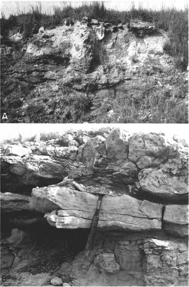
In Kansas the Relay Creek (?) dolomite and sandstone member is well developed only near the Oklahoma line, although sections exposing both the upper and lower dolomites are rare. In the NW sec. 18, T. 33 S., R. 16 W., and in the SE sec. 12, T. 33 S., R. 17 W., Comanche County, the upper dolomite and underlying sandstones are exposed in a shallow draw (Pl. 13A).
| Relay Creek (?) dolomite and sandstone member, Whitehorse sandstone, exposed in the NW sec. 18, T. 33 S., R. 16 W., and the SE sec. 12, T. 33 S., R. 17 W., Commanche County | Thickness, feet |
||
|---|---|---|---|
| Permian--Guadalupian (?) | |||
| Whitehorse sandstone--Relay Creek (?) dolomite | |||
| 7. Limestone, dolomitic, dense, gray (N6/0) to white to moderate orange-pink (5YR8/4); contains numerous areas of more coarsely crystalline calcite. Pink specimens contain brownish-red clay galls. Locally ripple-marked at top | 0.2-0.3 | ||
| 6. Sandstone, fine-grained, well-sorted, cross-bedded, very calcareous, white. Light-red (2.5YR6/6) 50 feet to south. Scattered flat calcite-sand concretions (1-2 cm diameter) at top | 0.5 | ||
| 5. Sandstone, fine-grained, well-sorted, cross-bedded, nearly unconsolidated, white (some red): grades downward into red sandstone | 3.4 | ||
| 4. Siltstone, calcareous, white to buff; one thin (<1 cm) bed contains salt casts up to 3 mm diameter | 0.2 | ||
| 3. Siltstone, argillaceous, dolomitic, light-gray mottled red | 2.7 | ||
| 2. Sandstone, fine-grained, fairly well-sorted, calcareous, red (2.5YR5/6) | 3.1 | ||
| 1. Siltstone, slightly argillaceous, thick-bedded, noncalcarcous, red (2.5YR5,/6) | 5+ | ||
| Total | 15.1 | ||
To my knowledge the dolomite is not present north of T. 33 S. White sandstones in the mid-Whitehorse farther north have been attributed to the Relay Creek (?) horizon, but their positive correlation is not clear. One such sandstone is along a road cut in the S. line SE~4 sec. 4, T. 33 S., R. 19 W., Comanche County, where the section is as follows.
| Whitehorse sandstone exposed in a road cut on the S. Iine SE sec. 4, T. 33 S., R. 19 W., Comanche County | Thickness, feet |
||
|---|---|---|---|
| Permian--Guadalupian? | |||
| Whitehorse sandstone | |||
| 6. Siltstone, slightly slabby, pale-yellow; contains many resistant calcareous veins trending in various directions | 4+ | ||
| 5. Siltstone, massive, bulging, pale-yellow (5Y8/3) | 5.0 | ||
| 4. Siltstone, coarse, noncalcareous, red (2.5YR5/6) | 3.1 | ||
| 3. Siltstone, pale-yellow; irregular base and top | 0.6±O.3 | ||
| 2. Siltstone, sandy, red; contains thin layers of small hard calcareous siltstone concretions. Color gradational at base | 1.8 | ||
| 1. Sandstone, fine-grained, friable, pale-yellow (5Y8/4); contains scattered large rounded grains in some areas; coarser at bottom; contains innumerable pockets and streaks of sand balls (not in horizontal beds) (Pl. 7D) | 6+ | ||
| Total | 20.5 | ||
The sand balls in the above section are best developed at the surface of the sandstone. They are somewhat friable, and some of them are hollow. The calcite cement is fine grained rather than a large, optically continuous crystal. The origin of these sand balls is obviously quite different from that of the sand balls studied by Norton (1939), and they are not a depositional feature.
Another possible correlative of the Relay Creek (?) member consists of 1.4 feet of white medium-grained sandstone (with sand balls) below red argillaceous siltstone in the SE sec. 7, T. 32 S., R. 21 W., Clark County.
Cragin's (1896, p. 43) type locality for the Red Bluff sandstones (Whitehorse) is on Bluff Creek west of Protection. Exposures in this area are in the lower part of Norton's even-bedded member of the Whitehorse formation. In the SW SE sec. 33, T. 32 S., R. 20 W., Comanche County, within a few feet of the stream, 25 feet of this member is exposed. The section is very similar to that illustrated by Hay (1890, p. 39).
| Whitehorse sandstone exposed along Bluff Creek in the SW SE sec. 33, T. 32 S., R. 20 W., Comanche County | Thickness, feet |
||
|---|---|---|---|
| Permian--Guadalupian? | |||
| Whitehorse sandstone--Even-bedded member | |||
| 13. Soil | |||
| 12. Siltstone, argillaceous, red | 1.9 | ||
| 11. Sandstone, very fine-grained, silty, somewhat resistant, red | 0.7 | ||
| 10. Siltstone, argillaceous, red | 2.4 | ||
| 9. Sandstone, very fine-grained, silty, somewhat resistant, red with poorly defined darker red streaks | 0.6 | ||
| 8. Siltstone, slightly argillaceous, seemingly massive, some- what calcareous, red (2.5YR5/7) | 2.4 | ||
| 7. Sandstone, very fine-grained, massive, red (2.5YR5/8); bulging appearance at crop; softer and coarser at top | 2.0 | ||
| 6. Siltstone, argillaceous, red; indistinctly thin-bedded | 4.0 | ||
| 5. Sandstone, very fine-grained, massive, resistant, red | 1.9 | ||
| 4. Siltstone, red | 2.3 | ||
| 3. Sandstone, very fine-grained, red; moderately soft with angularly fluted weathered surface | 4.6 | ||
| 2. Siltstone, sandy, greenish-gray; top and base irregular | 0.1 | ||
| 1. Shale, silty, dark-red | 2.5 | ||
| Total | 25.4 | ||
Series of alternating very fine-grained sandstones and siltstones, nearly all of which are red, are rather common in certain parts of the redbed section. They may perhaps be formed by migration of channels across a flood plain, as illustrated by Krynine (1949, p. 63).
The topmost 49 feet of the even-bedded member is exposed along Kiger Creek just north of U. S. Highway 160, in the SE SW sec. 3, T. 33 S., R. 24 W., Clark County.
| Even-bedded member, Whitehorse sandstone, exposed along Kiger Creek in the SE SW sec. 3, T. 33 S., R. 24 W., Clark County | Thickness, feet |
||
|---|---|---|---|
| Permian--Guadalupian? | |||
| Whitehorse sandstone--Even-bedded member | |||
| 15. Siltstone and very fine-grained sandstone; massive resistant, red; in indistinct beds | 4.0 | ||
| 14. Siltstone, argillaceous, red | 4.6 | ||
| 13. Sandstone, very fine-grained, resistant, red | 2.1 | ||
| 12. Clay shale, silty, red | 0.6 | ||
| 11. Siltstone, resistant, red with small greenish-gray spots | 2.8 | ||
| 10. Clay shale, silty, slightly dolomitic, red (2.5YR5/6) with two thin green streaks; contains a few rounded fine sand grains and small flakes of white mica | 3.0 | ||
| 9. Siltstone, resistant, red | 3.5 | ||
| 8. Clay shale, silty, red | 3.0 | ||
| 7. Siltstone, sandy, massive, resistant, red | 4.4 | ||
| 6. Clay shale, silty, red; 0.2-foot "bleached" zone in middle | 2.0 | ||
| 5. Sandstone, fine-grained, massive, resistant, red; some siltstone in lower part | 7.8 | ||
| 4. Clay shale, silty, red with 0.1 foot greenish-gray streak near center | 1.9 | ||
| 3. Sandstone, very fine-grained, silty, massive, friable, red (2.5YR5/7); contains uniformly scattered minute (0.1 to 0.3 mm) specks of a white flaky mineral, grown around some sand grains | 6.4 | ||
| 2. Clay shale, silty, greenish-gray | 0.2 | ||
| 1. Clay shale, silty, red (2.5YR4/6); contains a few greenish-gray (5GY7/1) irregular siltier areas | 3+ | ||
| Total | 49.3 | ||
In the NW sec. 29, T. 32 S., R. 21 W., Clark County, are exposures of a shalier part of the even-bedded member. The section in that locality is in the upper half of the member.
| Even-bedded member, Whitehorse sandstone, exposed in the NW sec. 29, T. 32 S., R. 21 W., Clark County | Thickness, feet |
||
|---|---|---|---|
| 8. Soil | |||
| Permian--Guadalupian? | |||
| Whitehorse sandstone--Even-bedded member | |||
| 7. Sandstone, very fine-grained, red (bleached white with red remnants in middle); massive, becoming thin-bedded at top; contains 5-mm sand balls | 3.9 | ||
| grades into | |||
| 6. Clay shale, slightly flaky, dark-red | 3.0 | ||
| 5. Clay shale, silty, red (with irregular light greenish-gray areas); upper part sandy and contains sand balls | 0.3 | ||
| 4. Clay shale and silty clay shale, red (2.5YR4/6); irregular fracture and curved slickensided surfaces, some with black film | 9.0 | ||
| 3. Sandstone, silty, massive, white (5Y8/1) with scattered irregular-shaped red areas in lower part | 3.4 | ||
| grades into | |||
| 2. Clay shale, silty, red with some greenish-gray spots | 5.6 | ||
| 1. Clay shale, slightly silty, red (2.5YR4/6); irregular fracture and curved slickensided surfaces, some with black film; scattered minute (<0.5 mm) dolomite crystals; breadcrust outcrop-surface suggesting presence of montmorillonite | 0.4+ | ||
| Total | 25.6 | ||
Another exposure in the upper part of the even-bedded member is in a road cut along the E. line SE sec. 26, T. 33 S., R. 23 W., Clark County.
| Even-bedded member, Whitehorse sandstone, exposed in road cut along E. line SE sec. 26, T. 33 S., R. 23 W., Clark County | Thickness, feet |
||
|---|---|---|---|
| Permian--Guadalupian? | |||
| 9. Soil (colluvium) | |||
| Whitehorse sandstone--Even-bedded member | |||
| 8. Sandstone, very fine-grained, red; contains nearly vertical thin veins of calcite with small sand balls up to 2 mm diameter; bulging outcrop surface | 4+ | ||
| 7. Claystone, silty, very calcareous, reddish-yellow (5YR6/6); mud cracks at top, up to 3 mm deep and 12 mm diameter; curvature concave up | 2.5 | ||
| 6. Sandstone, fine-grained, massive, friable, bulging, red; contains diagonal white joints (former calcite veins?) | 5.4 | ||
| 5. Sandstone, very fine-grained, glistening (calcareous), red | 2.7 | ||
| 4. Siltstone, calcareous, red (lens) | 0.05 | ||
| 3. Siltstone, argillaceous, red | 2.0 | ||
| 2. Sandstone, very fine-grained, massive, bulging, red; contains diagonal calcite-sand ball veins | 5.3 | ||
| 1. Siltstone, massive, red | 3+ | ||
| Total | 25+ | ||
The sand balls in this locality are dense, and the calcite is coarsely crystalline. However, their occurrence in diagonal veins does not suggest primary deposition.
Another type of sand ball in the even-bedded member may be found in a 6-foot bed of red and white very fine-grained sandstone overlying red argillaceous siltstone in a small box canyon in the SW sec. 4, T. 33 S., R. 24 W., Clark County, near U. S. Highway 160. The sand balls here are calcareous and football-shaped, and are uniformly smaller than 7 mm in diameter. They are dense enough to weather out from the softer sandstone. Many of them display smaller knobs on their surfaces. Some of them are intergrown with their long axes normal to each other. These are obviously not worn to that shape.
The upper shale member is described by Norton seemingly principally from the exposures in some prominent buttes about 10 miles north of Freedom, Oklahoma, about 6 miles south of the Kansas line. Norton (1939, p. 1806) describes this section as including, from base to top, a two- or three-member dolomitic horizon (the dolomites each about one-half foot thick) in maroon clay shale containing interlocking calcite crystals; brick-red sandy clays; a calcareous sandy lentil; a thin hard red sandstone; more soft red sandstones; a thin maroon shale; and 4 to 7 feet of graygreen sandy shale.
The basal dolomites were not recognized by me in the Kansas exposures of this member; the base of the unit in Kansas is not clearly defined. All thick clay shale beds within 40 feet of the base of the Day Creek dolomite and not associated with sand-ballbearing sandstones are assumed to be within the upper shale member.
The basal dolomitic horizon in the exposures 10 miles north of Freedom has a total thickness of about 6 feet. The dolomite (and the more abundant calcite, as shown by x-ray diffraction) are coarsely saccharoidal in texture and contain numerous clay galls of greenish-gray (5GY6/1) montmorillonitic clay up to 1 cm in diameter. Removal of the clay by weathering gives the dolomite-calcite a cellular character. The soft red sandstone 6 to 20 feet above the dolomite is very fine-grained and highly calcareous, but the associated white sandstones are essentially noncalcareous and more argillaceous. Norton's thin maroon shale must be classed here as a red (2.5YR5/6) slightly calcareous very argillaceous siltstone; the clay fraction seemingly is montmorillonitic. The topmost bed, the gray-green sandy shale, is similar to that in some Kansas exposures. The upper part (1 foot) is a pale yellow (2.5Y8/4) argillaceous, silty, very fine-grained sandstone with scattered specks of a white flaky mineral.
The top bed of the upper shale member (3 feet) at the Kiger Creek locality (SE SW sec. 3, T. 33 S., R. 24 W., Clark County) is almost entirely a white (2.5Y8/2) friable dolomitic very fine-grained sandstone, grading downward into red very fine-grained sandstone. It is marked by scattered sand-size (60 to 100 microns) flakes of a chlorite mineral.
More than 60 feet of the Whitehorse formation, including all the upper shale member and part of the even-bedded member, is exposed along a stream in the NE sec. 27, T. 31 S., R. 22 W., Clark County.
| Upper part of Whitehorse sandstone exposed along a stream in the NE sec. 27, T. 31 S., R. 22 W., Clark County | Thickness, feet |
||
|---|---|---|---|
| Permian--Guadalupian? | |||
| Day Creek dolomite | 2+ | ||
| Whitehorse sandstone | |||
| 15. Sandstone, argillaceous, very fine-grained, white; red in lower part | 3.0 | ||
| 14. Clay shale, silty, red | 1.9 | ||
| 13. Siltstone, sandy, red | 1.1 | ||
| 12. Clay shale, silty, red | 1.5 | ||
| 11. Siltstone, resistant, massive, red | 2.2 | ||
| 10. Clay shale, silty, red | 4.7 | ||
| 9. Siltstone, shaly, fairly resistant, red | 9.0 | ||
| 8. Clay shale, highly calcareous, hard, reddish-brown (5YR5/4); silty in upper part | 11.5 | ||
| 7. Siltstone, argillaceous, greenish-gray; some irregular red areas (base of upper shale member?) | 1.2 | ||
| 6. Clay shale, silty, and argillaceous siltstone; red; partly covered | 10.8 | ||
| 5. Siltstone, resistant, massive, red | 0.9 | ||
| 4. Shale, silty, red with greenish-gray irregular spots | 3.7 | ||
| 3. Shale, silty, soft, red; contains a few thin (0.3 foot) red siltstone beds | 5.0 | ||
| 2. Siltstone, argillaceous, red | 3.2 | ||
| 1. Sandstone, very fine-grained, red; bulging outcrop surface | 1+ | ||
| Total | 62.7 | ||
Plate 13--A, Thin dolomite and white sandstone at top of Relay Creek? member, Whitehorse formation; sec. 12, T. 33 S., R. 17 W., Comanche County. B, Day Creek dolomite and underlying cross-bedded sand; SW sec. 3, T. 33 S., R. 24 W., Clark County.
The base of the upper shale member is arbitrarily placed at the top of the 10.8-foot red silty clay shale.
The topmost beds of the upper shale member are exposed in the Cen. sec. 14, T. 32 S., R. 23 W., Clark County, where the greenish-gray clay shale is well developed. At this locality 1 foot of greenish-gray shale underlies and grades into the fine-grained yellowish-gray sandstone beneath the Day Creek dolomite.
Day Creek Dolomite
Exposures of the Day Creek dolomite in Kansas are restricted to Clark County north of Cimarron River. In Oklahoma, however, a dolomite formation correlated with the Day Creek of Kansas crops out for about 60 miles in a southeast-trending belt in Harper and Woodward Counties (Norton, 1939, pp. 1760-1761). The formation was named by Cragin (1896, p. 44) from exposures at the head of Day Creek in Clark County, Kansas, a few miles east of Ashland.
The Day Creek in Kansas consists of a single bed of pale-gray to pink dense fine-grained dolomite ranging in thickness from 2 to 3 feet. At some localities the formation contains chert nodules and disseminated chert. The origin of the chert is reported to be post-Permian and is related to the Cenozoic deposits (Norton, 1939, p. 1811). Weathered surfaces of the dolomite are characterized by intricately wavy ridges (Pl. 14A), and this character has led to its tentative correlation with the "crinkly limestones" of northeastern Colorado, the Forelle limestone of Wyoming, and the Minnekahta limestone of the Black Hills (Norton, 1939, p. 1812).
Plate 14--A, Weathered and fresh surfaces of chip of Day Creek dolomite; sec. 33, T. 32 S., R. 22 W., Clark County. x0.8 B, Casts of halite crystals in argillaceous siltstone from Dog Creek shale. x0.9. [Note: web versions are enlarged to show more detail.]
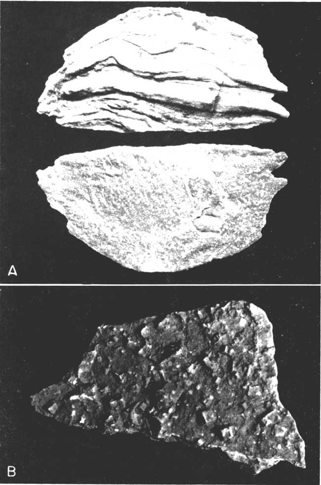
The dolomite in the type area (sec. 33, T. 32 S., R. 22 W.) is approximately 2 feet thick. Outcrops are poor and the rock is found chiefly as rubble on slopes. The wavy structure is well developed on the float blocks, and small chert nodules (generally less than 2 mm diameter) and stringers are common; they are particularly obvious in parts of the dolomite which are weathered. Calcite-lined vugs and nodules of red very calcareous siltstone are also present. This rock is of complex origin and deserves detailed study. Up to 30 percent of the dolomite in the type area is acid-insoluble and consists in part of globular drusy chert. Future petrographic study may indicate whether or not any of this chert is primary in origin.
Better exposures of the Day Creek dolomite may be seen at the Kiger Creek locality in the SW SW sec. 3, T. 33 S., R. 24 W., Clark County (Pl. 13B). The dolomite here is 2.2 feet thick. The upper 1.1 foot is cherty and extremely vuggy; the middle 0.6 foot is light-gray and dense, but in places slightly geodal. The lower 0.5 foot is similar to the middle, but also has yellow and purple streaks. This part is gradational downward into hard, well-cemented, dolomitic, well-sorted very fine-grained sandstone.
The Day Creek dolomite is well exposed along the section road on the E. line sec. 19, T. 31 S., R. 22 W., Clark County. The total thickness at this locality is 2.3 feet; the upper two-thirds is white, and the remainder is faintly pink and purple and sandy. The upper surface of some of the dolomite in this general area has a siliceous crust, even where it underlies the basal greenish-gray montmorillonitic shales of the lower Taloga formation. This suggests that perhaps the Cenozoic deposits were not the only source of the silica. If the lower Taloga shale is bentonitic, silica may have been leached from volcanic ash and deposited at the top of the Day Creek dolomite.
In the Cen. sec. 14, T. 32 S., R. 23 W., the Day Creek dolomite is approximately 2.1 feet thick. The color is predominantly white.
The Day Creek 10 miles north of Freedom, Oklahoma, is 3 feet thick, light-gray to white, rather coarsely crystalline to very fine-grained, and highly calcareous.
Taloga Formation
The Taloga formation includes all Kansas Permian deposits which are stratigraphically higher than the Day Creek dolomite. The outcrop area is restricted to western Clark County and southeastern Meade County, and according to Moore and others (1951) its maximum thickness is about 45 feet. The formation consists primarily of montmorillonitic shale, silty shale, siltstones, and some very fine-grained sandstones. The color is predominantly red, except for the lowermost few feet, which is greenish-gray clay shale. The units, except for the lower clay shales, are rather thin beds, generally thinner than 3 feet.
The lower Taloga is well exposed near the Cen. sec. 14, T. 32 S., R. 23 W., Clark County.
| Lower part of Taloga formation, exposed near the Cen. sec. 14, T. 32 S., R. 23 W., Clark County | Thickness, feet |
||
|---|---|---|---|
| Permian--Guadalupian? | |||
| Taloga formation | |||
| 4. Clay shale, somewhat silty, hard, dolomitic, thin-bedded, reddish-brown (2.5YR4/4); breaks into small irregular fragments; contains a few thin (<1 cm) white coarsely crystalline calcite layers which have red streaks | 4+ | ||
| 3. Siltstone, resistant, red (mottled white); coarsely crystalline dolomitic and calcite cement; parts contain small (<5 mm diameter) brownish-red clay galls | 3.1 | ||
| 2. Clay shale, silty, or argillaceous siltstone; red (2.5YR4/8); hackly fracture | 14.8 | ||
| 1. Clay shale, montmorillonitic, grayish yellow-green (5GY7/2); looks bentonitic; breadcrust surface | 3.1 | ||
| Day Creek dolomite | |||
| Total | 25.0 | ||
The lower part of the Taloga formation is poorly exposed in the SE SW sec. 19, T. 31 S., R. 22 W., Clark County. The lowermost grayish yellow-green clay, here only 2 feet thick, has a peculiar granular appearance caused by an abundance of minute dolomite rhombs (less than 0.5 mm diameter). The overlying red silty clay shale is nearly 20 feet thick but includes a few thin mottled red and white silty argillaceous very finegrained dolomites and a white dolomitic siltstone. One of these beds contains red clay galls similar to those in the preceding section. It also contains grayish-green clay galls having minute dolomite rhombs.
Beds higher within the Taloga, but at an unknown distance above the base, are exposed in a few stream valleys in southeastern Meade County. In the SE sec. 3, T. 24 S., R. 26 W., is a small exposure immediately above the bed of a tributary to Fivemile Creek.
| Taloga formation exposed in stream bank in the SE sec. 3, T. 24 S., R. 26 W., Meade County | Thickness, feet |
||
|---|---|---|---|
| Permian--Guadalupian? | |||
| Taloga formation | |||
| 9. Siltstone, argillaceous, soft, red; mostly covered | 6.2 | ||
| 8. Siltstone, sandy, argillaceous, soft (but ledge-forming), massive, red (2.5YR5/8); contains scattered large rounded sand grains; micaceous (unoriented flakes) | 1.3 | ||
| 7. Siltstone, very soft, slightly slabby, argillaceous, red (2.5YR5/8) | 0.7 | ||
| 6. Siltstone, very argillaceous, resistant, red (2.5YR5/8) | 2.6 | ||
| 5. Clay shale, silty, red (2.5YR4/6) | 1.8 | ||
| 4. Sandstone, silty, hard, light-red (2.5YR6/6) and some light-gray; calcite and dolomite cement; contains scattered large rounded sand grains | 0.1 | ||
| 3. Clay shale, silty, red (2.5YR4/6); somewhat micaceous; montmorillonitic | 2.0 | ||
| 2. Siltstone, sandy, micaceous, indistinctly thin-bedded, red (2.5YR5/8); contains white flaky mineral in clumps around silt grains | 3.2 | ||
| 1. Sandstone, very fine-grained, silty, rather resistant, slabby, red (2.5YR5/8); contains mica as in overlying bed | 1+ | ||
| Total | 18.9 | ||
Summary of Subsurface Stratigraphy
The following review of Leonardian and Guadalupian? subsurface stratigraphy in Kansas and adjacent areas is based on published descriptions and cross sections by Norton (1939), Maher (1946, 1947, 1948), Edson (1947, 1947a), Collins (1947), Lee (1949, 1953), and Maher and Collins (1952). The published information is based almost entirely on examination of rotary cuttings, because the redbeds are not cored. The deposits are characteristically irregular and lenticular, with facies changes common in relatively short distances, so that the placing of formation and group boundaries depends to a large degree upon the interpretation of the individual geologist.
Wellington Formation
The Wellington formation, which is said (Moore and others, 1951) to be about 700 feet thick at its outcrop, seemingly attains its greatest thickness (in Kansas) in southern Barber County, where Lee (1949) reports 980 feet of Wellington in his No. 2 well. The formation thins toward the northwest, and is only about 200 feet thick in western Wallace County near the Colorado line.
Norton (1939, p. 1758) and Lee (1949) describe the subsurface Wellington as including an upper gray shale member, a middle salt member, and a lower anhydrite member, with a few thin dolomite beds in the lower part. The thickest salt is penetrated in wells in Kingman, Barber, Ford, and Gray Counties; it is interstratified with gypsum or anhydrite. In some wells the salt member is 400 to 500 feet thick. The base of the salt grades downward into dolomite (Lee, 1953, p. 7). The thick evaporites wedge out toward the north and west, although thin salt beds are reported higher in the Wellington in the southwestern part of the State (Edson, 1947). Near the Colorado line evaporites are represented only by thin beds of dolomite and anhydrite, and most of the shale is maroon rather than gray. Fine-grained red sandstone is reported (Maher, 1947, 1948) in the Wellington of eastern Colorado and western Kansas.
Normal lower Wellington rocks grade into "granite wash" in the western part of the Oklahoma panhandle and the northwest corner of the Texas panhandle, acording to the cross section by Edson (1947a). Granite wash is described by Ward (1952) as a term used to designate deposits of granite conglomerate, arkose, and a conglomeration of decomposed and disintegrated acidic and basic igneous rock.
The top of the Wellington is difficult to identify in well cuttings, because the color change from gray to red is neither abrupt nor complete (Collins, 1947, p. 3). According to Maher (1948) an important unconformity at the top of the Wellington is indicated in Kansas and Nebraska, although this feature is difficult to identify in well cuttings and is not apparent in surface exposures. The Milan limestone does not seem to be prominent in subsurface samples. Wellington shale grades to red in Oklahoma,
Ninnescah Shale
The Ninnescah is predominantly a silty shale throughout Kansas. Its thickness at the outcrops averages about 300 feet, but its maximum outcrop thickness is reported to be about 450 feet (Moore and others, 1951, p. 40). In the subsurface the formation thins northward; near the Nebraska line it is only 50 feet thick.
Near the area of outcrop the subsurface Ninnescah is predominantly red or maroon shale with a very few (two to four) discontinuous dolomite beds in the lower part (Lee, 1949). Toward the west and north the lithology becomes more diverse. Edson (1947) portrays salt beds in the upper part of the formation in Ford, Hodgeman, and Finney counties, and several beds of dolomite and anhydrite throughout. Maher (1946) describes the Ninnescah of west-central Kansas as consisting chiefly of red and brown shale and thin beds of sandstone, dolomite, and fibrous gypsum. He also notes that the formation becomes sandier west of the Kansas-Colorado line. It also is sandier in the Oklahoma panhandle (Cimarron County) and there also includes thin salt beds (Edson, 1947a).
Maher (1947) depicts anhydrite, dolomite, salt, thick maroon shales, and thin sandstones in the Ninnescah of southwestern Kansas (Scott, Kearny, and Hamilton Counties). He does not discuss the significance of the facies changes from anhydrite in these counties to fibrous gypsum a few miles to the north.
Westward gradation to fine-grained red sandstone is well shown in Collins' (1947) cross section through Trego, Gove, Logan, and Wallace counties in northwestern Kansas.
The top of the Ninnescah shale is marked by a few feet of fine-grained Runnymede sandstone which immediately underlies the Stone Corral dolomite-anhydrite. Norton (1939, p. 1774) reports that the Runnymede has been identified in well cuttings from central and northwest Kansas in Pratt, Stafford, Ellis, Rooks, Osborne, Russell, and Ellsworth counties. Some more recent workers, however, do not stress its value as a horizon marker. Lee (1949) reports no sandstone at the top of the Ninnescah, even though the wells he studied (in Barber and Kingman counties) are fairly near the outcrop area. Maher (1946) shows thin red shaly sandstone at the top of the Ninnescah in wells in Ness, Lane, and Scott counties, but not in wells directly to the west (except in southeastern Colorado, where the Ninnescah in general is sandier). Sand is not consistently present at the top of the Ninnescah in the tier of counties from Wallace to Trego (Collins, 1947).
Stone Corral Dolomite
The base of the Stone Corral dolomite is regarded generally to be conformable on the underlying Ninnescah shale (Maher, 1946, 1947; Collins, 1947; Lee, 1949).
The Stone Corral, although a porous dolomite at the outcrop, is primarily anhydrite in the subsurface, where it commonly is known as the Cimarron anhydrite in Kansas. This formation, which disappears south of Reno County at the outcrop, is not reported in the near-by subsurface in Kingman, Harper, and eastern Barber counties (Lee, 1949). To the west, however, the Stone Corral is a good marker bed and consists chiefly of white to buff crystalline anhydrite with associated thin beds of maroon shale, grayish-yellow dolomite, pink finely crystalline limestone, and salt (Maher, 1946, 1947). It attains a maximum thickness of 100 feet in Scott County (Norton, 1939, p. 1781). It thins to the northwest, and is not readily identified in eastern Colorado.
A possible minor unconformity at the top of the Stone Corral is reported (Maher, 1946, 1947, 1948; Collins, 1947).
Nippewalla Group
The Nippewalla group includes the Harper sandstone, Salt Plain formation, Cedar Hills sandstone, Flowerpot shale, and Blaine-Dog Creek formations. The Harper, Salt Plain, and Cedar Hills formations are so similar in well cuttings that they are not commonly differentiated. For this reason the following paragraph describes the general characteristics of the three formations as a unit.
The Harper formation in the subsurface of eastern Barber and Kingman counties is described by Lee (1949, p. 2) as "entirely similar" to the Ninnescah shale. Farther west, however, the Harper, Salt Plain, and Cedar Hills are represented by thick red sandy shales and fine silty sand containing lenses of salt, anhydrite, and dolomite (Maher, 1946, 1947). Maher (1946, 1947) reports the presence of salt in the Salt Plain (?) in Kearny and Scott counties. He also mentions orange polished round sand grains in the Cedar Hills sandstone, but does not consider them unique, because similar sandstones are present in other parts of the Permian System in eastern Colorado (Maher, 1947, p. 4).
The Harper, Salt Plain, and Cedar Hills formations, which have an average thickness of 665 feet at their outcrop (Moore and others, 1951, p. 39), are thickest in the subsurface in the southwestern part of Kansas (Hugoton embayment), where in western Stevens County they total 690 feet (Edson, 1947a). That this is in the direction of the center of a local depositional basin is suggested by the presence of much salt in the section in Dallam County, extreme northwest corner of Texas (Edson, 1947a). The section thins and becomes sandier toward the northwest in Colorado (Maher, 1947).
The Flowerpot shale, 170 to 190 feet thick at the outcrop in Barber County, is fairly easily identified in well cuttings except in the westernmost part of the State. It is described (Maher, 1946, 1947) as a soft gypsiferous maroon shale. Its greatest thickness in Kansas is seemingly in the area of the outcrop. There is no obvious unconformity at the top of the Flowerpot in Kansas.
Blaine Formation and Dog Creek Shale
The Blaine formation at its outcrop in south-central Kansas near the Oklahoma line consists of four or fewer named gypsum members (Medicine Lodge, Nescatunga, Shimer, and Haskew) separated by dolomite and red shale, and is overlain by the maroon silty shales, dolomites, and dolomitic siltstones of the Dog Creek formation. The total thickness of the two formations at their surface exposures is about 64 to 103 feet. In the subsurface these formations cannot everywhere be differentiated, but they thicken tremendously toward the west. The greatest thickness is in the area of northwestern Kearny County, where about 235 feet of red shale and anhydrite were penetrated by a drill hole. In general, the Blaine-Dog Creek of the subsurface consists chiefly of red shale in the upper part and pink to white crystalline anhydrite in the lower part. The anhydrite is interbedded locally with red or maroon shale, and in places the upper red shale is missing. Collins (1947, pp. 2-3) reports that the lower half of the Blaine in a well in Gove County consists of red oolicastic anhydritic dolomite. According to Maher (1946, 1947) there is some salt in the lower part of the Blaine in Hamilton, Kearny, and Scott counties.
The evaporites thin markedly in Colorado, and in some places to the north and west they are also more dolomitic. Lee (1953) reports that the Blaine-Dog Creek is dominantly dolomite near the margin of the basin in Rush and Edwards counties. Maher (1947, p. 3) writes that the Blaine probably is equivalent to part of the lower Lykins formation of the Purgatoire River Valley.
According to Maher (1946, p. 3) the presence of an unconformity at the top of the Dog Creek cannot be proved or disproved by his investigations.
Whitehorse Sandstone
At its surface exposures in Kansas the Whitehorse sandstone is about 270 feet thick and consists predominantly of very fine grained red sandstones and siltstones with a few beds of shale and occasional dolomites. In the subsurface it also includes thin stringers of dolomite and anhydrite (Maher, 1946). In Kansas it attains its maximum thickness in Kearny County, where it is more than 300 feet thick (Maher, 1947). It thickens even more in eastern Colorado, and then thins toward the west (Maher and Collins, 1952).
Day Creek Dolomite
The Day Creek dolomite, a uniform thin bed at its surface exposures, shows much variation in the subsurface. In some wells it is entirely anhydrite; in some it consists of two brown or pink dolomite beds separated by red shale or anhydrite; in some it is represented by thin-bedded anhydrite and red shale (Maher, 1947, p. 3). It attains its greatest thickness (120 feet) in northeastern Morton County (Maher and Collins, 1952, sheet 3), where it is predominantly anhydrite.
Taloga Formation
The upper limit of the Taloga formation is at the erosional unconformity at the top of the Permian System, and its former thickness is not known. In the subsurface it consists of red sandy shale, fine red silty sandstone, and thin beds of anhydrite and dolomite (Maher, 1947). It is thickest in northeastern Morton County, where Maher (1947) reports a thickness of about 225 feet. The area of its greatest original thickness of course is not known.
In general, nearly all the lower Permian (and Pennsylvanian) rocks grade into arkose toward the Front Range, and thin toward the Sierra Grande uplift. Part of the Kansas Permian (Wolfcampian) is an equivalent of the Fountain arkose (Maher, 1953) which is described by Krynine (1949) as a true tectonic arkose. However, in post-Wolfcampian time when the Front Range was low and the post-Fountain deposits became quartzose, feldspathic material was being contributed to the Kansas part of the Permian basin.
Prev Page--Stratigraphy, Leonardian || Next Page--Mineralogy
Kansas Geological Survey, Geology
Placed on web Aug. 25, 2006; originally published May. 1955.
Comments to webadmin@kgs.ku.edu
The URL for this page is http://www.kgs.ku.edu/Publications/Bulletins/111/03_strat2.html