![]()
Prev Page--Introduction || Next Page--Stratigraphy, Guadalupian?
Stratigraphy
The exposures of Permian rocks in Kansas range in age from lower Wolfcampian to upper Leonardian and possibly Guadalupian. The Wolfcampian rocks, which have a total outcrop thickness of about 785 feet, are predominantly thin, persistent, evenly bedded limestones and shales, most of which were deposited under normal marine conditions (Elias, 1937). At least two of the limestone formations and several other beds are dolomitic, and several of them contain abundant chert. The thickest limestone formation, the Barneston, is about 80 to 90 feet thick. The interbedded shale units are green, gray, and red in color, and some of them contain marine fossils.
The lithologic difference between Wolfcampian and Leonardian rocks is pronounced. Computation of the number of feet of the various lithologies, based on Moore and others (1951) indicates that Wolfcampian rocks include 290 feet of limestones, 375 feet of gray shales, 95 feet of red shales, 25 feet of sandstones, 1 foot of coal, and less than 1 foot of gypsum. The post-Wolfcampian rocks, on the other hand, are predominantly red and reddish-brown siltstones, shales, and sandstones, with significant quantities of evaporites.
The major redbeds of the Permian System in Kansas are thus post-Wolfcampian in age (Leonardian Series and younger (?)). According to the classification of the State Geological Survey of Kansas (Moore and others, 1951, pp. 37-38), the topmost 290 feet of Permian rocks is within the Guadalupian Series. A graphic column of Kansas rocks published later (Moore and others, 1952) indicates an indefinite upper boundary for the Leonardian Series, and, no series designation for the deposits formerly referred to the Guadalupian. In this report the 1951 classification will be used, simply in order to provide a label for the younger deposits.
The problem of correlation of nonfossiliferous red clastics in Kansas with a type marine section in west Texas seems almost insurmountable, and it is not the concern of this study.
Above a few hundred feet of lithologically transitional gray, green, and red shales, thin discontinuous limestones and dolomites, gypsum, anhydrite, and thick salt in the basal part of the Leonardian section, the redbeds proper were deposited. Exposures are in general irregularly bedded, demonstrating pronounced facies changes (especially obvious in the subsurface); they consist predominantly of silty shales, feldspathic siltstones, and very fine-grained feldspathic sandstones and a few thin dolomite beds and one extensive gypsum formation (and in the subsurface anyhdrite and salt). The transitional beds have a total thickness of about 700 feet, and the overlying redbed formations at their outcrops have a combined thickness of about 1,500 feet. They thicken toward the southwest in the subsurface.
The redbed section (exclusive of the lower transitional part) is thought to consist of about 87 percent red rocks. The evaporites are not red, and a few thin beds of sandstone, siltstone, and silty shale are light buff to grayish green, but the predominant color is brownish red in the lower part (and in the red shales) and brilliant orange red in the upper sandstones and siltstones. Many of the exposures of units which actually are not red are commonly obscured by a red wash so that in general appearance the outcrops are remarkably uniform in color.
Mud cracks, ripple marks, salt casts, and a few rain prints are present at several horizons in the Leonardian and Guadalupian? rocks. Fossils are extremely scarce, and are limited to a few insects, problematical worm borings, pelecypods and brachiopods, and Cyzicus (Moore, Lalicker, and Fischer, 1952, p. 545), a brine shrimp, in the lowermost part of the section. Vertebrates of a type unknown to me have also been reported from the lower Leonardian rocks (Norton, 1939) but no reptilian tracks are known in Kansas.
The absence of fossils and the seeming lithologic similarity of the various redbeds in the section have made their subdivision into formations and members somewhat arbitrary. Many formational and member boundaries are marked only by a "bleached" zone or an evaporite unit, although formational units are more or less characterized by finer or coarser particle size, blocky or flaky appearance, slight differences in color, or some other common lithologic feature.
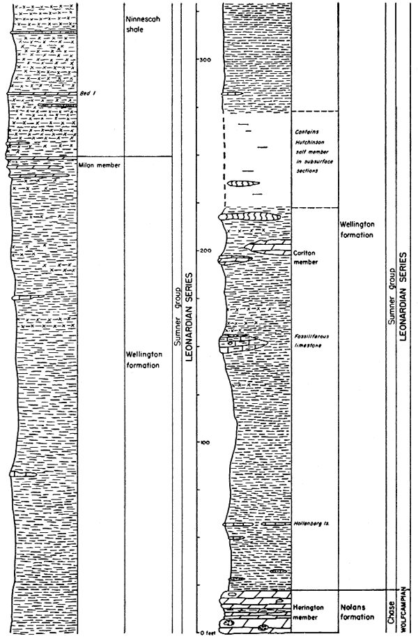
The classification of formations in the Leonardian and Guadalupian? Series used by the State Geological Survey of Kansas is shown in Table 1. This table also includes the average thickness and a brief lithologic description of each formation adapted in part from Moore and others (1951, pp. 37-41). A generalized rock column is shown in Figures 2 through 5.
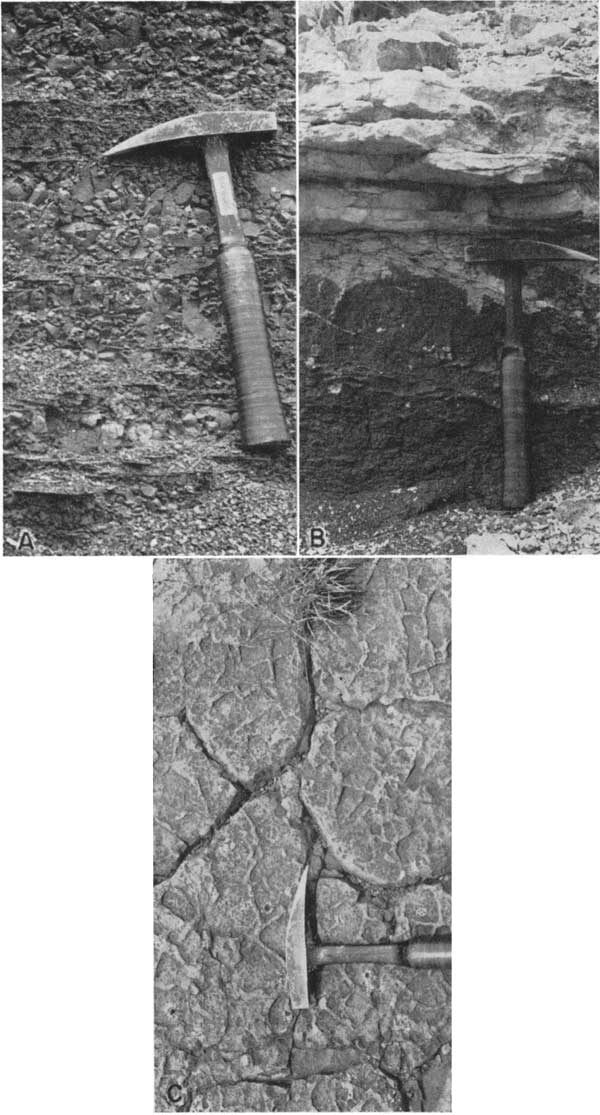
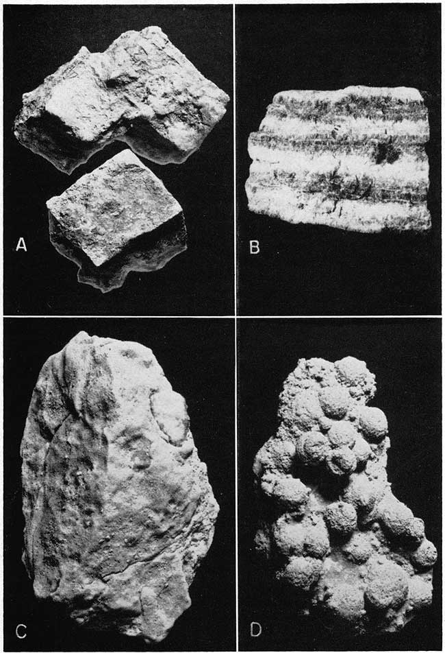
A brief description of the uppermost limestone member of the Wolfcampian Series is included here as a basis for comparison with the younger rocks. The Herington member of the Nolans limestone in southern Kansas is primarily a soft to dense, light yellowish-tan dolomite. It is characterized by siliceous and calcareous geodes and cauliflower-like concretions of rusy chalcedony. Mollusks are abundant in some localities. The member ranges in thickness from 7 to 30 feet. A geodal part of the Herington in a quarry face is shown in Plate 3A.
Table 1--Generalized section of the outcropping Leonardian and Guadalupian? formations of south-central Kansas.
| Series | Group | Formation | Member | Thickness, feet |
Character |
|---|---|---|---|---|---|
| ? | No group assignation |
Taloga fm. | 45+ | Shale, silty shale, siltstone, very fine sandstone, feldspathic, chiefly red, in thin beds. Lower 25 ft. silty shale. Bottom few feet greenish gray. In Meade and Clark Counties. | |
| Day Creek dolomite |
2 | Dolomite, dense, massive; gray, buff, and lavender. Clark County. | |||
| Whitehorse sandstone |
Sandstone, siltstone, feldspathic; shale, orange-red and (shale) brownish-red; and a few thin dolomites and limestones. Cross-bedding present, especially in lower part. Concretionary friable calcareous "sand balls" common. Meade, Clark, Kiowa, Comanche, and Barber Counties. | ||||
| (Upper shale) | 38 | Upper shale member consists of clay shale, siltstone, and thin fine-grained sandstone, red, locally with dolomite zone at base and gray-green silty shale in upper part. | |||
| (Even-bedded) | 100 | Even-bedded member: alternating red very fine sandstones and clayey siltstones, moderately thin-bedded, with occasional reddish-brown silty shales. | |||
| Relay Creek? dolomite and sandstone |
22 | Relay Creek dolomite and sandstone member consists of two thin beds (locally) of dolomitic limestone each less than 1 ft. thick separated by white and red locally cross-bedded fine feldspathic sandstone. | |||
| Marlow | 110 | Marlow member is predominantly red sandstone, feldspathic, generally soft, massive; locally clayey, silty, cross-bedded. | |||
| Dog Creek shale |
14 to 53 | Silty shale, brownish-red; siltstone, very fine sandstone, red. Also thin (<1 ft.) dolomites, dolomitic siltstones, and gypsum. Kiowa, Comanche, Barber Counties. | |||
| Blaine fm. | Gypsum beds, massive, locally with thin dolomites at base, separated by red shales. Kiowa, Comanche, and Barber Counties. | ||||
| Leonardian | Nippewalla | Haskew gypsum (red shale) |
<1 to 5 |
Gypsum, massive; present only locally; underlain by 5 ft. of red shale. | |
| Shimer gypsum |
14 to 24 | Gypsum, massive, overlying 0.5 to 1.5 feet of dolomite. | |||
| (red shale) |
4 to 9 | Shale, red. | |||
| Nescatunga gypsum |
2 to 8 | Gypsum, massive. | |||
| (red shale) | <9 | Shale, red, with selenite crystals. | |||
| Medicine Lodge gypsum |
20 (av.) to 30 |
Gypsum, massive, with anhydrite layer near middle; overlying 0.5 to 1 foot dolomite, oolitic. Forms rim rock at top of Flowerpot shale. | |||
| Flowerpot shale |
170 to 190 |
Shale, silty, brownish-red, with occasional thin gypsiferous and dolomitic sandstones, grayish-green; and thin grayish-green silty shales. Formation is characterized by numerous intersecting veins of satin spar and selenite crystals. Essentially restricted to Barber County. | |||
| Cedar Hills sandstone |
180 | Alternating thin (2 to 15 ft.) beds of very fine massive sandstone, red, friable; and clayey siltstones and silty shales, red. Sandstone, white, about 1 to 2 ft., with gypsum "snow balls" at top of formation. White sandstone, grading upward into red, at base. Barber County. | |||
| Salt Plain fm. |
265? | Silty shale, red (some with small spherical green spots), flaky; siltstone, and some sandstone. Two silty sand beds near top, locally cross-bedded. Underlies nearly featureless plain in Harper, Barber, and Kingman counties. | |||
| Harper sandstone |
Shaly siltstone, reddish-brown, and numerous thin sandy sittstones and a few very fine sandstones, reddish- brown with small, spherical gray-green spots. Harper, Kingman, Reno, and Rice Counties. | ||||
| Kingman sandstone |
80 | Shaly siltstone and very fine sandstone, reddish-brown. Silty sandstone white, 3 ft. thick, marks base. | |||
| Chikaskia | 100 to 160 |
Flaky siltstone, sandy siltstone, and silty shale, mostly red, but some greenish-gray. Some sandy dolomite lenses in upper part. | |||
| Stone Corral dolomite |
6 (max.) | Dolomite, light-buff to yellowish-gray (locally with red streaks), cellular (from loss of anhydrite or gypsum) and containing calcite-filled vugs. Ripple marks characteristic. Dolomite pinches out toward the south, where the formation consists chiefly of shale with scattered dolomite rhombs. Rice and Reno Counties. | |||
| Sumner | Ninnescah shale |
300 (av.) to 450 (max.) |
Predominantly silty shale, mostly dolomitic or calcareous, mostly brownish-red, blocky, with gray-green spots. contains several beds of dolomitic and calcareous siltstone, and associated gray-green, silty shale. Cyzicus present in lower part. The Runnymede sandy siltstone, 7 to 8 ft. thick and containing copper carbonate, forms the top of the formation. Harper, Sumner, Kingman, Sedgwick, Reno, Rice, and McPherson Counties. | ||
| Wellington fm. |
Ca 700 (including salt in subsurface) |
At outcrop chiefly shale and silty sha e, in part calcareous, mostly gray and green with some red especially in lower part. Contains lenticular beds of gypsum and soft fine-grained silty limestone and dolomite beds, some of which are named. The thin Milan dolomite at the top contains green copper carbonate. Formation contains Cyzicus. Sumner, Cowley, Sedgwick, Butler, Reno, Harvey, McPherson, and Marion Counties. | |||
| Wolfcampian | Chase | Nolans limestone |
Herington limestone |
7 to 30 | Dolomite, yellowish-tan, soft to dense, geodal; locally containing mollusks. |
Plate 3--A, Geodes in Herrington limestone, NE sec. 10, T. 27 S., R. 3 E., Butler County. B, Milan dolomite at type locality; SE sec. 30, T. 32 S., R. 3 W., Sumner County. C, Bed 1, Ninnescah shale; C W2 sec. 9, T. 28 S., R. 3 W., Sedgwick County.
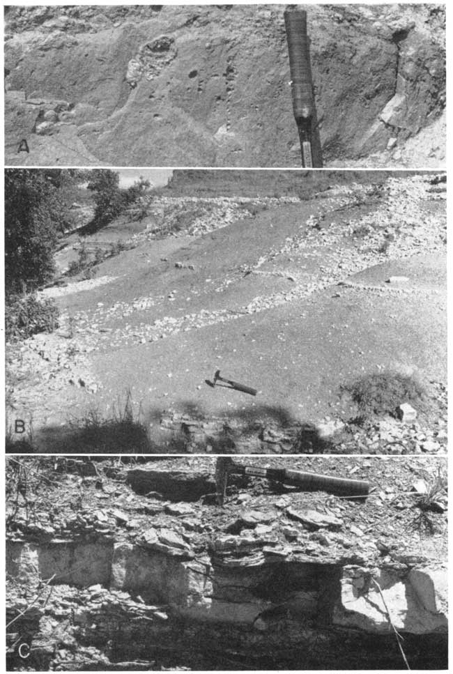
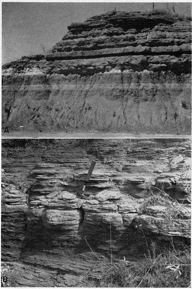
Figure 2--Generalized stratigraphic section, outcropping Permian rocks of post-Wolfcampian age in Kansas. Adapted in part from Moore and others (1951, 1952).
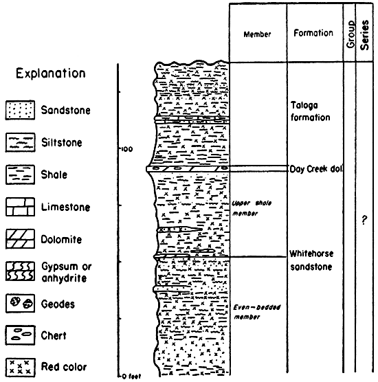
Figure 3--Generalized stratigraphic section, outcropping Permian rocks of post-Wolfcampian age in Kansas. Adapted in part from Moore and others (1951, 1952). See Figure 2 for explanation.
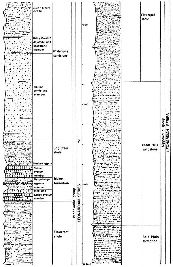
Figure 4--Generalized stratigraphic section, outcropping Permian rocks of post-Wolfcampian age in Kansas. Adapted in part from Moore and others (1951, 1952). See Figure 2 for explanation.
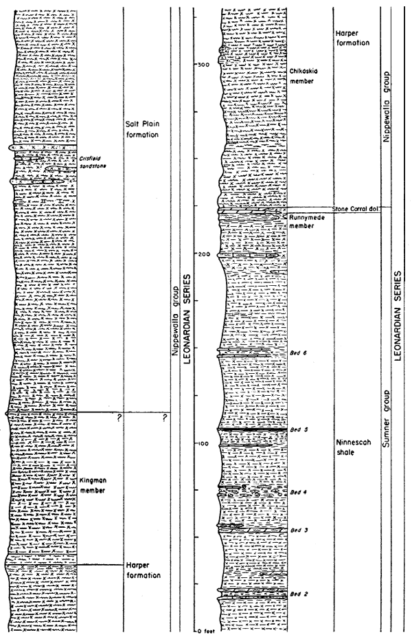
Figure 5--Generalized stratigraphic section, outcropping Permian rocks of post-Wolfcampian age in Kansas. Adapted in part from Moore and others (1951, 1952). See Figure 2 for explanation.
Leonardian Series
The lower Leonardian rocks in Kansas include most of the transition from the normal marine interstratified fossiliferous limestones and shales of the lower Permian (Wolfcampian) to the typical redbeds of the upper part of the Permian section. The topmost formation of Wolfcampian age, the Herington limestone, differs chiefly from most of the underlying limestones in its dolomitic character, but is not otherwise unusual.
The advent of Wellington deposition in Kansas represents a marked change in conditions. Instead of marine limestones and shales, a thick sequence of fine elastics and evaporites was laid down. Succeeding formations in the Permian sequence are characterized by evaporites and chiefly red clastics, somewhat coarser than those of the Wellington. In general, the younger rocks are the coarsest and the most feldspathic, although nowhere in the surface outcrops of Permian rocks in Kansas is the average particle size coarser than that of fine sand.
Sumner Group
The Sumner group, according to Moore and others (1951, p. 40) consists of about 1,000 feet (at the outcrop) of gray, red, and green shale, thin siltstones, and deposits of dolomite, limestone, gypsum, and anhydrite. [Note: In the stratigraphic sections which follow, the siltstones and sandstones are not labeled "feldspathic, even though all samples examined in the laboratory are found to contain from 10 to 30 percent feldspar. The reason for this is that the estimation of feldspar in field studies of these very fine-grained, deeply stained rocks is not feasible. To name only the paler, relatively coarse sandstones feldspathic would introduce a false connotation.] Thick beds of salt occur in the subsurface. The group includes the Wellington formation, Ninnescah shale, and Stone Corral dolomite.
Wellington Formation
Rocks of the Wellington formation are poorly exposed in a broad north-south-trending strip which extends entirely across the State of Kansas from Sumner and Cowley Counties at the Oklahoma line to Washington and Marshall Counties at the northern boundary. The formation was originally named and described by Cragin (1885, 1896) for exposures at the City of Wellington in Sumner County, Kansas. As now defined by the Kansas Geological Survey, it includes all beds above the Herington limestone (topmost Wolfcampian) and below the Ninnescah shale (base of the "redbeds" proper).
The surface exposures of the Wellington consist primarily of gray to greenish-gray somewhat silty shales having subconchoidal fracture. There are some beds of brownish-red, maroon, and purple shales, particularly in the upper part of the formation, and many of the shale units are somewhat calcareous. Numerous thin lenticular silty limestones (less than 15 feet thick) and dolomites occur throughout the section, and a few discontinuous beds of gypsum are also exposed. The thick section of salt, which is exploited in the subsurface, is of course destroyed in surface exposures, but a brief description of the salt seen in the Carey mine at Hutchinson is included in this report. Solution of this salt and gypsum at or near the surface has produced rather steeply dipping small-scale structures at many localities.
The basal beds of the Wellington formation are fairly well exposed in a stream bank in the SE NE sec. 21, T. 34 S., R. 3 E., Cowley County, a short distance southeast of Geuda Springs. This exposure, although poor, was considered by Bass (1929) as one of the best in Cowley County, and consists primarily of gray-green clay shales, in part calcareous. The rocks exposed are as follows.
| Lower part of Wellington formation, exposed in stream bank in the SE NE sec. 21, T. 34 S., R. 3 E., Cowley County | Thickness, feet |
||
|---|---|---|---|
| Permian--Leonardian | |||
| Wellington formation | |||
| 11. Limestone, hard, vesicular, light yellowish-brown to gray, weathered, badly slumped. Hollenberg? | 5 + | ||
| 10. Shale, yellowish gray-green, seemingly structureless | 6.9 | ||
| 9. Marl, thin-bedded, light-gray; contains calcite veins | 1.5 | ||
| 8. Shale, calcareous, medium light-gray | 1.7 | ||
| 7. Marl and horizontal calcite streaks | 0.9 | ||
| 6. Shale, calcareous, medium light-gray | 6.0 | ||
| 5. Calcite veins (horizontal) in shale | 0.1 | ||
| 4. Shale, calcareous, medium light-gray (Munsell N6), has subconchoidal fracture; contains a few thin dark-maroon beds | 2.8 | ||
| 3. Marl, light-gray | 0.6 | ||
| 2. Covered | 10.3 | ||
| 1. Shale, medium light-gray, partly covered | 15.0 | ||
| Permian--Wolfcampian | |||
| Nolans limestone--Herington limestone member (in stream bed) | |||
| Total | 50.8 | ||
The limestone exposed at the top of this section may be a correlative of a bed that was later named the Hollenberg limestone by Condra and Upp (1931, pp. 63-66) from exposures along Little Blue River 3.5 miles southeast of Hollenberg, Washington County, Kansas. This bed is dolomitic and is seemingly one of the very few wide-spread thin limestone units in the Wellington formation.
A few local limestones lithologically similar to the Hollenberg are found slightly higher in the section. One of these, Ver Wiebe's (1937) Udall limestone lentil, is exposed in the road ditch along the S. line SW SW sec. 21, T. 30 S., R. 3 E., where it consists of 1.5 feet of gray to brown, very dense, hard, coarsely vesicular limestone and coarsely crystalline calcite in the usual section of gray-green shale. Like the Hollenberg, it probably once contained anhydrite crystals.
A higher lenticular limestone of Herington aspect (although chiefly calcareous rather than dolomitic) is exposed in an abandoned quarry in the NW sec. 36, T. 31 S., R. 2 E., Sumner County, on a high bluff overlooking Arkansas River. This is the bed noted by Norton (1939, p. 1757) and said by him to be about 125 feet above the Herington limestone. More than 10 feet of impure somewhat clayey cream-colored limestone is exposed in this quarry. The upper part weathers to slabby, soft material, but some of it is hard and massive where fresh. The upper part is geodal, as is the Herington. The middle third is very fossiliferous, with numerous large brachiopods (Derbyia) and occasional cup corals and gastropods.
The upper part of the lower Wellington shales is exposed in a stream bank in the NW sec. 29, T. 18 S., R. 2 E., Marion County. The beds here are stratigraphically a few feet below the horizon of the Carlton limestone. The section here contains, from top to bottom, about 10 feet of gray and brownish-gray shales with intercalated thin calcareous layers and thin-bedded siltstones showing minute "cut-and-fill" micro-bedding. Below this is 0.6 foot of light-gray calcareous shale and then 0.8 foot brownish-gray silty shale. At the base is 3+ feet of light-gray dense impure limestone. Many joints in the upper shales and limestones are filled with pink to orange crystalline material composed of dolomite and celestite.
The Carlton dolomitic limestone member, which is reported to occur a short distance below the Hutchinson salt (Moore and others, 1951, p. 41) consists of about 60 feet (Ver Wiebe, 1937, p. 5) of gray-green (and some maroon) shales containing numerous discontinuous lenses of white earthy limestones. A Carlton dolomite lens is well exposed in a quarry in the NE sec. 30, T. 19 S., R. 2 E., Marion County. The bed has a minimum exposed thickness of 5 feet, and consists primarily of cream-colored thinbedded (<0.5 foot), dense earthy dolomite. Its upper surface is bulging or undulatory, and mud cracks (some at intervals of 10 inches) are common. One bed having a thickness of about 3 inches is composed of large oolites up to 0.5 mm in diameter and flat angular fragments of dense dolomite as large as one-half inch thick and 4 inches long.
Another Carlton area which also shows some of the adjacent shales is along the N. and W. lines NW sec. 32, T. 34 S., R. 1 E. The section there follows.
| Part of Wellington formation, including Carlton member, along N. and W. lines NW sec. 32, T. 34 S., R. 1 E., Sumner County | Thickness, feet |
||
|---|---|---|---|
| Permian--Leonardian | |||
| Wellington formation | |||
| 15. Limestone, slabby, cream-colored | 0.1 | ||
| 14. Clay shale, brownish-gray | 4.3 | ||
| 13. Clay shale, greenish-gray | 3.1 | ||
| 12. Limestone, argillaceous, pale-gray | 0.1 | ||
| 11. Clay shale, smooth, weak-red and green | 0.7 | ||
| 10. Limestone, slabby, cream-colored | 0.3 | ||
| 9. Clay shale, gray | 2.8 | ||
| 8. Shale, smooth, slickensided, noncalcareous, weak-red (Munsell 2.5YR4/2); weathers into very small splinters | 3.5 | ||
| 7. Clay shale, dark-gray; weathers slightly bluish | 7.0 | ||
| 6. Limestone, slabby, cream-colored | 0.2 | ||
| 5. Clay shale, gray and weak-red | 0.8 | ||
| 4. Limestone, slabby, cream-colored; contains small (<2 inch diameter) mud cracks | 0.5 | ||
| 3. Covered, probably gray shale | 3.0 | ||
| 2. Limestone, slabby, argillaceous, light-gray; interbedded with thin (<0.4 foot) calcareous shales. Main benchformer | 5.5 | ||
| 1. Clay shale, dark-gray | 1+ | ||
| Total | 32.9 | ||
In the early summer of 1951, beds a short distance above the horizon of the Carlton member were exposed in an old pit in the W. line NW sec. 33, T. 19 S., R. 1 E., Marion County. The abandoned pit exposed a small domelike or noselike structure. The section was not measurable, but consisted of green and dark-gray noncalcareous blocky clay shales, some brownish-red shale, and thin beds (<0.5 foot) of light-gray calcareous shale or argillaceous limestone. Some of the gray shale immediately below a calcareous layer breaks along the bedding planes and shows small depressions in the upper side, with corresponding bumps on the lower side. The depressions range from very minute to 3 mm in diameter and are shallower than wide. They have almost no raised rims, but are presumably rain-drop impressions or gas pits. There are approximately 20 to the square inch. Mud cracks are well developed in some of the light-gray calcareous material. Their depth is not great, and they are about 2 inches apart. The fill is 1 to 4 mm wide and consists of darker, not very calcareous brownish-gray material. By October 1951 this exposure had been destroyed.
The middle part of the Wellington formation is chiefly comprised by the Hutchinson salt member, and is very poorly exposed at the surface. A small section in the Hutchinson salt may be seen in the workings of the Carey salt mine at Hutchinson. There the working face shows a rather regular alternation of clear, white, coarsely crystalline halite, in beds several inches thick, with thin laminae of gray silty shale, gypsum, and anhydrite. Wallace Lee (oral communication) has indicated that these thin crinkly shaly interbeds with selenite or anhydrite crystals are diagnostic of salt zones in rotary cuttings.
Beds of middle Wellington gypsum are exposed in the vicinity of Wichita in Sedgwick County. There is some indication that the Hutchinson salt grades into gypsum toward the south and east (Bass, 1929, p. 101), that the original margin of the salt basin passed through Sumner County (Bass, 1926, p. 94), and that the vicinity of Wichita was not far from the margin. A remnant of a thin bed of gypsum is exposed in a stream bank in the NE NE sec. 3, T. 27 S., R. 1 E., Sedgwick County. The gypsum cropping out here is less than 4 feet thick, is partly removed by solution, and is associated with red and gray shales.
Thinly laminated green and gray shales and calcareous shales of the middle Wellington formation crop out in a stream bank on the N. line NW NW sec. 15, T. 24 S., R. 1 E., Harvey County. This is one of the lowermost sections in which Cyzicus (formerly Estheria), or brine-shrimp, is found. This fossil continues well up into the Ninnescah shale.
Another easily accessible minor exposure of middle Wellington shales occurs in the road ditch along U. S. Highway 160, at the Cen. N. line, sec. 16, T. 32 S., R. 1 E., Sumner County. About 30 feet of rocks here is poorly exposed. They are essentially gray-green soft clay shales containing at least three very thin slightly more resistant beds which are lighter in color and calcareous and which occur at intervals of about 10 feet. One of these includes a layer pock-marked with minute rectangular depressions having random orientation. These depressions, which may be salt casts, occur with a density of about 20 per square cm, and average about 1.5 mm in diameter. The uppermost resistant bed exposed at this locality is 0.1 foot of grayish-brown, calcareous, oolitic intraformational conglomerate having small rounded limestone and limonite fragments (<3 mm) and flat angular clay galls as large as 1 cm in long diameter.
A small exposure of clay shale somewhat above the middle of the Wellington formation occurs in a road ditch in the NE cor. sec. 28, T. 32 S., R. 1 W., Sumner County, and shows some of the color variation which is rather common in the upper part of the formation. The section follows.
| Wellington formation, exposed in road ditch in the NE cor. sec. 28, T. 32 S., R. 1 W., Summner County | Thickness, feet |
||
|---|---|---|---|
| Permian--Leonardian | |||
| Wellington formation | |||
| 7. Limestone, thin-bedded, slabby, argillaceous, white (10YR8/1) | 1.1 | ||
| 6. Clay shale, blocky, calcareous, medium-gray (N5/0) to greenish-gray (5GY6/1); weathers to orchid, gray, gray-green, and blue-green | 4.7 | ||
| 5. Clay shale, blocky, greenish-gray | 0.3 | ||
| 4. Clay shale, blocky, very slightly calcareous, pale-red (10R6/2); gradational color change at top and bottom | 0.8 | ||
| 3. Clay shale, blocky, grayish-green | 1.2 | ||
| 2. Clay shale, calcareous, light grayish-green (bench former) | 0.4 | ||
| 1. Clay shale, blocky, grayish-green | 3.2 | ||
| Total | 11.7 | ||
Multicolored shales are even more notable in a section somewhat higher in the formation, exposed near a stream in the NE SE sec. 17, T. 33 S., R. 2 W., Sumner County.
| Wellington formation, exposed near a stream in the NE SE sec. 17, T. 33 S., R. 2 W., Sumner County | Thickness, feet |
||
|---|---|---|---|
| Soil | |||
| Permian--Leonardian | |||
| Wellington formation | |||
| 17. Shale, red and green, poorly exposed | 0.9 | ||
| 16. Shale, silty, blocky, noncalcareous, reddish-brown (Munsell 2.5YR5/4) | 1.0 | ||
| 15. Marl, vuggy, white (10YR8/1) with red to nearly black hematite stains and brown limonite stain, contains scattered coarsely crystalline calcite and a pink fibrous very finely crystalline mineral (celestite?) | 0.2 | ||
| 14. Clay shale, blocky, slightly calcareous, grayish-red (5R4/1) | 1.3 | ||
| 13. Clay shale, greenish-gray | 0.1 | ||
| 12. Clay shale, calcareous, white (10YR8/1) | 0.8 | ||
| 11. Clay shale, noncalcareous, greenish-gray (5GY6/1) | 0.4 | ||
| 10. Clay shale, soft, noncalcareous, reddish-brown; yellow at top and bottom; curved slickensided surfaces | 2.8 | ||
| 9. Clay shale, blocky, calcareous, greenish-gray (5GY6/1) with discontinuous red streaks | 0.6 | ||
| 8. Clay shale, green and brown with red streak at top | 3.5 | ||
| 7. Clay shale, noncaleareous, reddish-brown (5YR4/3) mottled green; brownish at top | 3.3 | ||
| grades downward into | |||
| 6. Clay shale, noncaleareous, dark greenish-gray (5GY5/1) | 1.7 | ||
| 5. Clay shale, light brownish-gray (2.5Y6/2) with red and greenish-gray mottling; some mottling in concentric bands | 2.0 | ||
| 4. Clay shale, blocky, reddish-brown (2.5YR4/4); calcareous in pin-point spots; some slickensided surfaces | 3.8 | ||
| 3. Clay shale, blocky, noncalcareous, dark greenish-gray (5GY4/1) to greenish-gray (5GY6,/l); weathers to yellowish-green | 0.4 | ||
| 2. Limestone, blocky, argillaceous, or very calcareous shale; gray (various shades); faintly laminated with discontinuous wavy laminae; contains tiny faults | 0.5 | ||
| 1. Clay shale, greenish-gray | 1+ | ||
| Total | 24.3 | ||
Many of these colors may be recent features caused by difterential weathering stages of the ferrous iron.
The uppermost part of the Wellington section is characterized by numerous thin beds of earthy argillaceous limestone and dolomite. Some of these are exposed in the Cen. W. side sec. 9, T. 28 S., R. 3 W., Sedgwick County. At this locality are two limestones, each about 0.5 foot thick, separated by about 7 feet of gray calcareous shale containing 2 feet of maroon shale in the middle.
The top of the Wellington formation, at which the principal change in color from gray to red takes place in southern Kansas, is marked by the Milan limestone member. According to Norton (1939, p. 1758), this member includes three thin limestones (one or more of which may be missing) in the topmost 8 feet of the Wellington formation. The three limestones, which are dolomitic and baritic in at least some localities, are less than a foot thick, and characteristically contain malachite in small spots, said to be weathered from chalcopyrite. The section in the type locality, SE SE sec. 30, T. 32 S., R. 3 W., 2 miles south of Milan, Sumner County (Pl. 3B), is given below.
| Section at type locality of Milan Iimestone, SE SE sec. 30, T. 32 S., R. 3 W., Sumner County | Thickness, feet |
||
|---|---|---|---|
| Permian--Leonardian | |||
| Ninnescah shale | |||
| 12. Clay shale, blocky, noncalcareous, dark reddish-brown (2.5YR3/4) | 0.5+ | ||
| 11. Limestone, dolomitic, argillaceous, light-gray | 0.7 | ||
| 10. Clay shale, calcareous, blocky, light greenish-gray | 0.4 | ||
| 9. Clay shale, blocky, dark reddish-brown | 3.3 | ||
| 8. Clay shale, blocky, maroon | 1.4 | ||
| 7. Clay shale, dark-gray and dark-maroon | 1.6 | ||
| 6. Limestone, very argillaceous, gray | 0.3 | ||
| 5. Clay shale, blocky, dark-maroon | 1.1 | ||
| 4. Clay shale, blocky, dark-green and some maroon | 0.7 | ||
| Wellington formation--Milan limestone member | |||
| 3. Limestone, dolomitic, white or yellowish-gray (5Y8/1); contains malachite, pink celestite, and barite | 0.9 | ||
| 2. Clay shale, grayish-green | 0.4 | ||
| 1. Covered to stream | 10 | ||
| Total | 21.3 | ||
The Milan limestone and the color change from gray and maroon in the Wellington formation to brownish-red in the Ninnescah shale are well exposed in the Cen. S. side sec. 9, T. 28 S., R. 3 W., Sedgwick County. At this locality there is a marked color contrast between the purplish red below and reddish brown above.
Ninnescah Shale
Exposures of the Ninnescah shale in Kansas extend from the Kansas-Oklahoma line to northern McPherson County and southeastern Ellsworth County where they are covered by Cretaceous rocks. The outcrop belt is about 110 miles long in a north-south direction and is approximately 22 miles wide at its broadest point near Oklahoma. Like the Wellington, the Ninnescah forms a low, rather featureless plain with only local areas of outcrops. The formation has an average outcrop thickness of 300 feet (Moore and others, 1951, p. 40); it thickens to about 450 feet toward the Oklahoma line, and thins to 50 feet in the subsurface near the Nebraska line. It consists primarily of brownish-red, calcareous and dolomitic, blocky, silty clay shales, commonly with scattered greenish-gray spots; plus occasional thin silty dolomites or dolomitic siltstones and rarely silty limestones or calcareous siltstones. Norton (1939) has noted seven principal scarp-forming beds in the Ninnescah which according to him can be traced for some distance along their strike. The Ninnescah is capped by the Runnymede member, a grayish-green, copper-bearing, sandy siltstone about 8 feet thick.
The formation was named by Norton (1939, p. 1767) from its exposures on both forks of Ninnescah River in south-central Reno County and north-central Kingman County. It includes all beds from the top of the Milan limestone to the top of the Runnymede member or the base of the Stone Corral dolomite.
The seven principal scarp-forming beds described by Norton are summarized below.
Bed 1 is dove-gray, dense, platy limestone, normally less than 1 foot thick; it breaks into small rectangular blocks stained with copper carbonate and is mud-cracked, pocked, pitted, and locally oblitic. This bed lies between green shales each half a foot thick, and 5 feet above a calcareous bed; in some places it is red, in some places contains salt casts, and commonly is veined with coarsely crystalline calcium carbonate 30 to 35 feet above the base of the Ninnescah. This bed contains Cyzicus, and maintains its limestone character for 40 miles, extending into Oklahoma.
Bed 2 is gray calcareous sandstone (siltstone?) in a ripple-marked double bed with 2 feet of red shale between the sandstone units. Thickness is 1 to 5 feet. Traceable for 60 miles, it increases in thickness and becomes cross-bedded near the Oklahoma line. Bed 2, which contains many Cyzicus shell impressions, lies about 100 feet above the base of the Ninnescah. Slightly more than 35 feet below Bed 2 is a thin, calcareous, fissile, ripple-marked sandstone (siltstone?) forming a low bench. Immediately above this bench, near Caldwell, Norton found some bone fragments and two teeth, but did not describe the type of animal they represented.
Bed 3 is sandy (silty?) limestone, 1 to 2 feet thick, and 10 to 40 feet above Bed 2. Bed 3 becomes double to the north, the two sandstones (siltstones) being separated by thin red shale. The upper surface of the bed is ripple-marked and pocked as with worm borings. The bed becomes sandier toward the Oklahoma line, as do the underlying shales.
Bed 4 consists of three thin dense gray limestones separated by largely green (but some red) shales, totaling 5 feet in thickness, and 15 to 20 feet above Bed 3. According to Norton (1939, p. 1771) Bed 4 can be traced for 25 miles or more and is characterized by rosette-shaped calcareous concretions on weathered surfaces. The deposits between beds 3 and 4 consist of red and gray shales with a thin geodal middle limestone.
Bed 5 is sandy limestone which is gray, thin-bedded, rather fissile, 1 foot thick (locally several feet thick), and about 30 feet above Bed 4. The upper surface is ripple-marked and mudcracked, and Cyzicus and salt casts are present. A calcareous concretionary shale layer 6 inches thick occurs 1 foot above, and a black geodal dolomitic limestone 8 feet below; exposed near Castleton in Reno County.
Bed 6 comprises two limestones separated by 1 to 3 feet of red and gray shale, about 40 feet above Bed 5, and underlain by a thin bed of brick-red sandstone. The limestones contain salt casts, and the topmost part is locally shaly and ripple-marked. Bed 6 is a scarp former and is exposed near Castleton. Toward the south the limestones grade into thick green calcareous shales separated by thin red shale. Between Beds 5 and 6 are red shales containing many thin green calcareous shale bands with calcareous nodules.
Bed 7 is a calcareous sandstone, gray, 1 to 2 feet thick in central Kingman County, 60 feet above Bed 6. Cyzicus is common, and is not found stratigraphically higher than this in Kansas. Toward the Oklahoma line, Bed 7 becomes cross-bedded, and there is also more gray-green calcareous shale in the underlying beds toward the south. Above Bed 7 are red and gray shales, the top part becoming sandy toward the north and containing more limestone toward the south.
The topmost bed of the Ninnescah shale is known as the Runnymede member. It consists of about 8 feet of greenish-gray clayey sandy siltstone. The member was named by Norton (1939, pp. 1773-1774) from the town of Runnymede in northeastern Harper County.
Beds in the lowermost part of the Ninnescah shale are well exposed at the type locality of the Milan limestone in sec. 30, T. 32 S., R. 3 W., Sumner County, and there show transitional features between the Milan and Norton's Bed 1 (see measured section and Pl. 3B). Bed 1 is exposed near the Cen. S. line sec. 30 at the top of a small pit in typical brownish-red clay shale. Less than 1 foot of gray-green clay shale underlies the limestone, which is a light-gray, dense, earthy, and pitted dolomitic rock having a thickness of about 8 inches.
Bed 1 is better exposed in a road cut in the Cen. W. line sec. 9, T. 28 S., R. 3 W., Sedgwick County. The limestone here is 0.9 foot thick and contains a pink mineral (celestite?). It lies between two 6-inch beds of gray-green clay shale. The adjacent shales contain many thin veins of calcite having columnar structure. The exposure is shown in Plate 3C.
One hundred feet of Ninnescah shale, including the strata between Beds 1 and 3, is exposed on both sides of U. S. Highway 81 south of Caldwell in secs. 12, 13, and 14, T. 35 S., R. 3 W., Sumner County. At this locality many lateral variations take place within a few hundred yards, and few beds can be traced with certainty from one hillside to the next without showing some differences in lithology.
One section measured south of Caldwell follows. The section starts near Bluff Creek on the east side of the railroad bridge, sec. 12, and continues to the top of the hill in sec. 13, T. 35 S., R. 3 W.
| Ninnescah shale near Bluff Creek in secs. 12 and 13, T. 35 S., R. 3 W., Sumner County | Thickness, feet |
||
|---|---|---|---|
| Permian--Leonardian | |||
| Ninnescah shale | |||
| 42. Dolomite, silty, or dolomitic sandy siltstone; dense, light-gray to brown to pale-red (2.5YR6/2); contains Cyzicus. Norton's Bed 2? To the west one-fourth mile this is a reddish-brown (5YR5/4) cross-bedded dolomitic sandy siltstone; scale of cross-bedding ca. 1 cm | 5.0 | ||
| 41. Covered | 1.1 | ||
| 40. Limestone, silty, or dolomitic siltstone; slabby, gray | 0.7 | ||
| 39. Clay shale, blocky, red-brown; contains thin gray resistant silty shale beds | 15.0 | ||
| 38. Siltstone, calcareous, white (10YR8/1); mud-cracked, ripple-marked | 1.2 | ||
| 37. Clay shale, blocky, greenish-gray | 1.0 | ||
| 36. Clay shale, blocky, reddish-brown with green spots | 2.0 | ||
| 35. Siltstone, resistant, light-gray | 0.2 | ||
| 34. Clay shale, blocky, reddish-brown with green spots, especially near top | 5.8 | ||
| 33. Limestone, silty, light-gray; slightly geodal | 1.3 | ||
| 32. Clay shale, gray | 0.4 | ||
| 31. Clay shale, blocky, reddish-brown; contains two thin light-gray resistant silty shale beds | 12.0 | ||
| 30. Dolomite, silty, light-brown (5YR6/4); cross-bedded (1 cm thick); vertical "worm borings" 1 mm diameter, lined with calcite | 0.7 | ||
| 29. Clay shale, gray-green (irregular base) | 0.8 | ||
| 28. Clay shale, blocky, reddish-brown | 8.1 | ||
| 27. Siltstone, fine-grained, noncaleareous, white (10YR8/2); contains scattered dwarf Cyzicus and holes which may be minute gas pits | 0.3 | ||
| 26. Clay shale, blocky, reddish-brown | 3.0 | ||
| 25. Siltstone, argillaceous, blocky, resistant, pale-red; 0.3 foot white streak in center (30 yards away, another white streak present in lower part) | 1.3 | ||
| 24. Clay shale, blocky, reddish-brown | 4.1 | ||
| 23. Siltstone, argillaceous, resistant, calcareous, white | 0.1 | ||
| 22. Clay shale, blocky, reddish-brown | 0.9 | ||
| 21. Geodes, calcareous, white; bench-forming; a thin vesicular bed with trace of associated greenish-gray shale | 0.1 | ||
| 20. Clay shale, blocky, reddish-brown | 5.3 | ||
| 19. Shale, dolomitic, calcareous, slabby, light greenish-gray (5GY7/1); bench-forming; grades downward to red shale; contains thin beds (<1 cm) of dolomitic siltstone | 0.8 | ||
| 18. Clay shale, blocky, brownish-red with green-gray streaks at top and bottom | 1.0 | ||
| 17. Shales, interbedded thin red and gray; mostly red at base | 0.8 | ||
| 16. Clay shale, light grayish-green | 0.1 | ||
| 15. Clay shale, red and greenish-gray mottled; upper surface slightly wavy with 1.0 cm "chicken scratches" | 4.0 | ||
| 14. Clay shale, blocky, brownish-red | 6.3 | ||
| 13. Clay shale, crumbly, gray-green | 0.1 | ||
| 12. Shale, silty, hard, calcareous, light greenish-gray (5GY7/1); bench-forming; mud cracks one-half to 1 cm diameter; contains trace copper carbonate and some coarsely crystalline calcite (Norton's Bed 1?) | 0.4 | ||
| 11. Clay, very slightly calcareous, soft, crumbling, light olive-gray (5Y6/2) | 0.4 | ||
| 10. Clay shale, silty, crumbly, somewhat calcareous, reddish-brown (2.5YR4/4) with widely scattered small greenish-gray spots (<3 mm diameter) | 2.2 | ||
| 9. Shale, silty, calcareous, pale-red (10R6/2) (gray to pink-streaked); conchoidal fracture; forms bench | 0.8 | ||
| 8. Clay shale, blocky, reddish-brown | 0.9 | ||
| 7. Clay shale, greenish-gray | 0.1 | ||
| 6. Clay shale, crumbly, reddish-brown | 0.1 | ||
| 5. Clay shale, blocky, reddish-brown (2.5YR4/4); contains scattered greenish-gray spots and curved black slickensides having metallic luster; in part a very calcareous microbreccia or intraformational conglomerate | 3.0 | ||
| 4. Shale, silty, hard, calcareous, gray-green; forms bench | 0.1 | ||
| 3. Clay shale, crumbly, reddish-brown | 5.2 | ||
| 2. Clay shale, slightly silty, hard, very calcareous, grayish yellow-green grading to red at base and top | 0.3 | ||
| 1. Clay shale, blocky, reddish-brown (2.5YR5/4); contains a few greenish-gray horizontal streaks 1 to 30 mm in diameter | 8+ | ||
| Total | 105.0 | ||
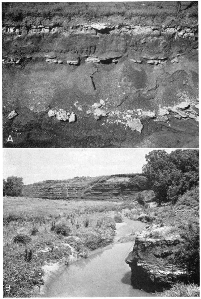
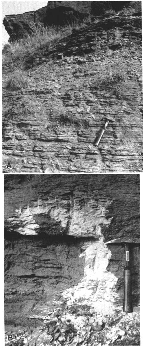
Some features of the Caldwell exposures are shown in Plate 4. Plate 4A shows the spotted blocky brownish-red shale with calcite veins which is typical of the entire Ninnescah section. Plate 4B is a detail of the "bleached" area below a dolomite. Plate 4C shows three orders of mud cracks in a pale red argillaceous siltstone in the middle part of the section.
Plate 4--Exposured in Ninnescah shale; sec. 14, T. 35 S., R. 3 W, Sumner County. A, Brownish-red blocky silty shale with calcite veins typical of Ninnescah formation. B, Detail of bleached area below a silty dolomite. C, Three orders of mud cracks in pale-red argillaceous siltstone.
Bed 2 as described by Norton is exposed in a hillside and road ditch along the N. line NE sec. 4, T. 27 S., R. 4 W., Sedgwick County. The upper bed is a light greenish-gray (5GY8/1) dolomitic siltstone 1.3 feet thick which has a ripple-marked upper surface. The ripples are essentially symmetrical in cross section, with an average amplitude of about 1 mm, wave length of 100 to 150 mm, and a N 150° W strike. The lower part of this bed contains horizontal calcite veins. The middle reddish-brown (2.5YR4/5) calcareous silty shale is 3 feet thick and has scattered greenish-gray spots up to 3 mm diameter. The lower bed is yellowish-gray (5Y8/1) poorly sorted unconsolidated clastic limestone with calcite crystals (2 mm diameter) in the lower part. The calcite fragments are sand size, and the superficial appearance is that of a fine-grained quartz sandstone.
Norton's Bed 3, a silty dolomite, is exposed in the northwest bank of Sand Creek in the NW sec. 27, T. 29 S., R. 4 W., Sedgwick County. The section at this locality is given below.
| Ninnescah shale exposed in northwest bank of Sand Creek in the NW sec. 27, T. 29 S., R. 4 W., Sedgwick County | Thickness, feet |
||
|---|---|---|---|
| Permian--Leonardian | |||
| Ninnescah shale | |||
| 3. Dolomite, silty, light greenish-gray (5GY8/1); contains vertical (3 mm diameter) worm borings in upper part | 1.2 | ||
| grades into | |||
| 2. Clay shale, gray-green | 0.8 | ||
| 1. Clay shale, blocky, reddish-brown; contains calcite veins and a few zones with spherical green spots | 15+ | ||
| Total | 17.0 | ||
A similar silty dolomitic limestone, possibly also Bed 3, has been quarried in the NE sec. 14, T. 34 S., R. 4 W., Sumner County. The rock is a light-gray silty dolomite, 1.5 feet thick, with ripple marks, mud cracks, and green shale partings. It overlies several feet of normal reddish-brown blocky clay shale.
Worm borings are not everywhere present in Bed 3, nor are they restricted to this bed. Borings were noted in an unnumbered silty dolomite at a lower horizon (between Beds 1 and 2) in the hills south of Caldwell.
The three layers of Bed 4 may be seen clearly in road ditches along the N. line sec. 5, T. 26 S., R. 4 W., and the S. line sec. 32, T. 25 S., R. 4 W., Reno County (Pl. 5A). The section at this locality follows.
Plate 5--A, Geodal facies of Ninnescah Bed 4; SE sec. 32, T. 25 S., R. 4 W., Reno County. B, Runnymede siltstone (foreground) and Chikaskia soltstone (background) at type locality; SE SE sec. 10, T. 31 S., R. 6 W., Harper County.
| Ninnescah shale exposed in road ditches along the N. line sec. 5, T. 26 S., R. 4 W. and the S. line sec. 32, T. 25 S., R. 4 W., Reno County | Thickness, feet |
||
|---|---|---|---|
| Permian--Leonardian | |||
| Ninnescah shale | |||
| 9. Limestone, pale-green; variable thickness, about | 0.2 | ||
| 8. Clay shale, silty, very slightly calcareous, light greenish-gray (5GY8/1) | 0.6 | ||
| 7. Clay shale, blocky, brownish-red | 2.5 | ||
| 6. Calcite rosettes (geodes) and surrounding green shale | 0.4 | ||
| 5. Clay shale, blocky, brownish-red | 1.5 | ||
| 4. Calcite band or vein | <0.1 | ||
| 3. Clay shale, blocky, brownish-red | 2.5 | ||
| 2. Calcite rosettes (geodes), small (<10 cm diameter), and surrounding light greenish-gray calcareous shale | 0.4 | ||
| 1. Clay shale, blocky, gray-green | 0.6+ | ||
| Total | 8.8 | ||
The geodes consist of coarsely crystalline calcite, and the inside is coated with a bright-yellow material which turns buffcolored on exposure to air. Microchemical analysis indicates only CaCO3 in this material (R. T. Runnels, personal communication).
At the Cen. W. line sec. 31, T. 25 S., R. 4 W., the bottom "limestone," although thin, is not geodal, and the interval between the two lower beds is thinner. A section measured at this locality follows.
| Bed 4, Ninnescah shale, exposed along road at the Cen. W. line sec. 31, T. 25 S., R. 4 W., Reno County | Thickness, feet |
||
|---|---|---|---|
| Permian--Leonardian | |||
| Ninnescah shale | |||
| 6. Limestone, dull, white; contains groups of coarse calcite crystals; surface knobby; more resistant parts weather into relief | 0.2 | ||
| 5. Clay shale, blocky, gray-green | 0.4 | ||
| 4. Clay shale, blocky, brownish-red | 2.7 | ||
| 3. Limestone, argillaceous, geodal, light-gray; consists of masses of coarse calcite crystals, in part stained red, with a few scattered fragments of greenish-gray shale | 0.3 | ||
| 2. Clay shale, fine-grained, blocky, brownish-red | 1.9 | ||
| 1. Limestone, dolomitic, light greenish-gray; closely jointed, as in mud cracks | 0.2 | ||
| Total | 5.7 | ||
Norton's Beds 5 and 6 seemingly are no longer well exposed in the vicinity of Castleton, from which locality he originally described them. The area is rather flat, and very little shale is visible. A poor exposure of gray geodal dolomite less than 1 foot thick occurs in a road ditch along Kansas Highway 17 in the NW sec. 36, T. 25 S., R. 6 W. A light-gray thin hard silty limestone overlies red and green blocky clay shales in the SW sec. 27, T. 25 S., R. 6 W. About 0.8 foot of gray crumbly limestone, weathering white, occurs in the SW sec. 21, T. 25 S., R. 6 W. A dense hard gray limestone is poorly exposed in the SW sec. 13, T. 25 S., R. 6 W.
At Norton's locality for Bed 7 (SE NE sec. 2, T. 28 S., R. 6 W., Kingman County) is a poorly exposed 1-foot bed of white calcareous siltstone overlying brownish-red blocky clay shale. One-half mile to the south is a slightly thinner calcareous siltstone which contains calcite crystals, scarce ripple marks, and mud cracks.
Beds in the upper part of the Ninnescah are exposed in the NW sec. 30 and the SW sec. 19, T. 34 S., R. 5 W., Harper County. At this locality near the Oklahoma line, as pointed out by Norton (1939, p. 1772), the section includes more greenish-gray clay shales. The section follows.
| Upper Ninnescah shale in the NW sec. 30 and the SW sec. 19, T. 34 S., R. 5 W., Harper County | Thickness, feet |
||
|---|---|---|---|
| Permian--Leonardian | |||
| Ninnescah shale | |||
| 8. Siltstone, calcareous, gray; forms bench; contains thin finely drusy calcite veins | 0.6 | ||
| 7. Clay shale, silty, blocky, brownish-red; contains 0.2-foot red resistant clay shale in middle | 1.4 | ||
| 6. Siltstone, massive, calcareous, gray | 2.9 | ||
| 5. Clay shale, silty, blocky, reddish-brown | 1.1 | ||
| 4. Clay shales, silty, alternating thin gray and red-streaked | 0.8 | ||
| 3. Siltstone, massive, light-gray | 3.5 | ||
| 2. Clay shale, blocky, grayish-green | 0.5 | ||
| 1. Clay shale, hard, blocky, brownish-red | 1+ | ||
| Total | 11.8 | ||
The upper 30 feet of the Ninnescah shale is excellently exposed in bluffs in the SE NW sec. 8, T. 28 S., R. 6 W., Kingman County. The top of the bluffs is underlain by an orange-red friable calcareous siltstone containing many coarse calcite geodes. This lithology is similar to that of the basal Chikaskia. Underlying it is 5 feet of gray-green siltstone: the Runnymede facies. Below the siltstone is 28 feet of brownish-red blocky clay shale with numerous diagonal calcite veins, bands of thin gray siltstone, and a few layers of gray-green clay shale and calcite geodes.
The Runnymede member was examined at Norton's type area in the NE SE sec. 10, T. 31 S., R. 6 W., Harper County (Pl. 5B). According to Norton (1939, p. 1773) the beds are in a gradational facies at this locality, the Runnymede facies extending up into the Chikaskia member of the Harper formation. The section is as follows.
| Chikaskia-Ninnescah contact and transitional beds at type locality of Chikaskia member, in the NE SE sec. 10, T. 31 S., R. 6 W., Harper County | Thickness, feet |
||
|---|---|---|---|
| Permian--Leonardian | |||
| Harper formation--Chikaskia member | |||
| 14. Siltstone and silty shale, thin-bedded, brownish-red | 3+ | ||
| 13. Dolomite, silty, hard, mud-cracked, greenish-gray (5GY7/1) stained red; contains columnar calcite veins and thin angular fragments of green shale | 0.1 | ||
| 12. Siltstone, argillaceous, sandy, reddish-brown, and interbedded reddish-brown blocky clay shale | 4.0 | ||
| 11. Clay, silty, reddish-brown; contains argillaceous siltstone interbeds and hard calcareous concretions 1 to 3 inches in diameter; also coarsely crystalline calcite in veins associated with greenish-gray shale | 4.9 | ||
| 10. Clay shale, soft, blocky, reddish-brown (2.5YR4/5) | 1.7 | ||
| Transitional beds? | |||
| 9. Clay shale, calcareous, greenish-gray; contains dolomite rhombs (&ly;1 mm diameter) in vugs and clusters | 0.2 | ||
| 8. Clay shale, silty, soft, blocky, slightly calcareous, reddish-brown (2.5YR4/5); contains greenish-gray dolomite rhomb streak near base | 3.8 | ||
| 7. Siltstone, dolomitic, massive, hard, red (2.5YR4/6); contains slot-shaped holes (<1/8 inch) which possibly are salt casts, and minute (<0.5 mm) dolomite rhombs disseminated and in veins | 1.1 | ||
| 6. Clay shale, minutely blocky, brownish-red | 3.1 | ||
| Ninnescah shale? | |||
| 5. Siltstone, dolomitic, thin-bedded, Runnymede-type, greenish-gray (5GY6/1); in part with minute wavy streaks of dark-gray calcareous silty shale (thinner than 0.5 mm) and small areas of green copper carbonate | 0.8 | ||
| 4. Clay shale, silty, blocky, gray | 0.5 | ||
| grades into | |||
| 3. Siltstone, argillaceous, calcareous, blocky, reddish-brown (5YR5/4) | 3.5 | ||
| 2. Siltstone, calcareous, blocky, light greenish-gray (5GY7/1) | 2.4 | ||
| grades into | |||
| 1. Clay shale, silty, blocky, reddish-brown | 3.2 | ||
| Total | 32.3 | ||
As the Stone Corral dolomite is absent in Harper County, the beds of dolomite rhombs and shale presumably take its place. The greenish-gray Runnymede siltstone is abnormally thin here. According to Norton, it is commonly 8 feet thick. Four feet is exposed at the top of the Ninnescah in sec. 8, T. 28 S., R. 6 W., Kingman County.
Stone Corral Dolomtite
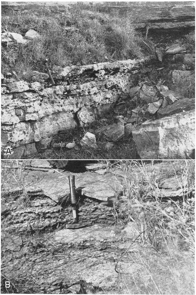
The Stone Corral dolomite was named by Norton (1939, p. 1775) from exposures in and near sec. 11, T. 20 S., R. 6 W., Rice County. Chiefly anhydrite in the subsurface, it is a key marker bed. In the outcrop area it loses its dolomitic character south of northern Reno County, and the horizon of the Stone Corral cannot be traced with certainty in the clay shales.
A small abandoned quarry (Pl. 6A) in the type area, NW cor. sec. 11, T. 20 S., R. 6 W., exposes the entire 6-foot thickness of the Stone Corral. The dolomite is dense to cellular, and grayish buff in color. It contains many vugs partly or completely filled with coarsely crystalline calcite or gypsum. The basal one-third is in part oolitic, with individual oolites up to one-half mm in diameter. Large oolites (1 mm diameter) also occur 2 feet below the top. The top 2 inches, also locally oolitic, is in part pink. The material of the oolites is more soluble, under ordinary conditions of weathering, than that of the matrix.
The top 3 feet of the Stone Corral is quarried for road material in the SE SE sec. 15, T. 20 S., R. 6 W. The rock is similar to that of the type locality, except that oolites are less abundant and the upper surface is locally ripple-marked. The weathered areas show well-defined beds with thicknesses up to 1 foot, and some surfaces are speckled with a dark material (possibly manganese dioxide).
Plate 6--Stone Corral dolomite. A, Exposure in old quarry face at type locality, NW cor. sec. 11, T. 20 S., R. 6 W., Rice County. B, Thin-bedded granular facies; S. line SE sec. 9, T. 22 S., R. 6 W., Reno County. Hammer head on red shale break.
The grayish-green silty shales underlying the Stone Corral in the type area are exposed in a road cut along the N. line sec. 22, T. 20 S., R. 6 W. According to Norton (1939, p. 1779), the underlying shales to the south in Reno County are maroon.
In northeastern Reno County, 13 miles south of the type locality, the Stone Corral is 4 feet thick where it crops out in the S. line SE sec. 9 and the W. line NW NW sec. 15, T. 22 S., R. 6 W. The rock here is grayish-buff in color and has a coarse sugary texture. It is porous but does not contain large vugs except on weathered surfaces. It weathers into thin beds (Pl. 6B) and includes a 2-inch brownish-red shale break about 0.8 foot below the top of the dolomite. The dolomite also contains short discontinuous red and gray shaly streaks abut 2 to 4 mm thick and clay galls 4 or 5 mm in long diameter.
In northern Kingman County the Stone Corral is exposed along the W. line NE sec. 22, T. 25 S., R. 7 W. The dolomite here has the same coarse sugary texture but is only 0.4 foot thick. It overlies 0.3 foot grayish-green shale, which is above at least 6 feet of brownish-red blocky clay shale with diagonal calcite veins. Farther south in Harper County the Stone Corral is represented only by scattered dolomite rhombs in silty shale.
Nippewalla Group
The Nippewalla group is described by Moore and others (1951, p. 38) as consisting mostly of redbeds that form a plain. The sediments of this group are primarily siltstones and very fine-grained sandstones, with minor quantities of silty shale and gypsum. The formations included in the Nippewalla are the Harper siltstone, Salt Plain formation, Cedar Hills sandstone, Flowerpot shale, Blaine formation, and Dog Creek shale.
Harper Formation
The Harper sandstones were named by Cragin (1896, pp. 18-19) from exposures in Harper County and particularly because of the low ledges of sandstones which were quarried near the City of Harper. Norton (1939, p. 1782) removed the Ninnescah and Stone Corral formations from Cragin's Harper sandstones and restricted the unit to the beds above the Stone Corral dolomite and below the flaky silty shales of the Salt Plain formation.
The Harper consists of 180 to 220 feet of brownish-red, spotted argillaceous siltstones and silty shales plus a few thin silty sandstones. It has been subdivided by Norton (1939, p. 1782) into the Chikaskia member, below, and the Kingman member, above.
Chikaskia member--The type locality of the Chikaskia member (named from Chikaskia River) is in sec. 10, T. 31 S., R. 6 W., Harper County, where the basal beds overlie the type Runnymede siltstone (Pl. 5B). The member consists primarily of brownish-red sandy siltstone to silty shale and ranges in thickness from 100 feet at the northernmost exposures in Kingman County to 160 feet near the Oklahoma line.
According to Norton (1939, pp. 1782-1783) the Chikaskia has three general divisions; from base to top:
1. At the base, is a highly variable sand and shale section, the soft red sandstones containing grotesque concretions and salt casts, the more resistant red sandstones, several feet thick, weathering at the ordinary exposure to an exfoliated, bulgy or pot-bellied appearance, each of these ledges being capped by gray, fissile, fine-grained, ripple-marked and in places crossbedded sandstone, the lower contact of which is very irregular so that the thickness varies abruptly from 1 or 2 feet to twice that thickness but everywhere levels off at the top. 2. Next is a series of bench-forming, well cemented, even-bedded, hard, red sandstones, weathering to a rough jagged surface, whose bcds are locally quarried for dimension stone. These beds. together with those above, far better than those underlying, represent the rock character ordinarily associated with the name "Harper sandstones." 3. The uppermost third of the Chikaskia is more variable in thickness than the beds above or below, and there is also considerable variation in the composition of the surata. There are numerous white sandstones of fair strength which serve to break up the redbed section but the most distinguishing characteristic of this part of the member, outside of its contact with the next higher member of the Harper, is the sugary-dolomite lentils and concretions in the red shales, characteristically polka-dotted with small green spots.
The basal Chikaskia at the type locality is described in the section on the Runnymede sandstone. In the absence of Stone Corral dolomite, definite placing of the base of the Harper formation is not feasible. Another section similar to that at Runnymede is poorly exposed in sec. 2, T. 28 S., R. 6 W., Kingman County, where massive red siltstones 1 to 2 feet thick are interbedded with soft red silty shales. The sandy siltstone overlying the Runnymede in the SE NW sec. 8, T. 28 S., R. 6 W., Kingman County is orange-red, friable, and contains many coarse calcite geodes.
The lower Chikaskia is well exposed in the SW SW sec. 5, T. 28 S., R. 6 W., Kingman County, in a road ditch along the west line and also along the south line. At this locality are large crystal casts of red siltstone and calcite having the shape of curved rhombs (presumably dolomite rhombs, Pl. 7A). The section follows.
| Lower part of Chikaskia member, Harper formation, exposed in road ditches in the SW SW sec. 5, T. 28 S., R. 6 W., Kingman County | Thickness, feet |
||
|---|---|---|---|
| Permian--Leonardian | |||
| Harper formation--Chikaskia member | |||
| 13. Siltstone, argillaceous, calcareous, thinly laminated, red (2.5YR5/6); upper one-third contains bands of columnar calcite and gray siltier laminae | 7.5 | ||
| 12. Siltstone, slabby, red with scattered tiny green spots | 6.7 | ||
| 11. Shale, silty, red; contains thin calcite seams | 0.8 | ||
| 10. Siltstone, slabby, red | 4.8 | ||
| 9. Siltstone, very calcareous, friable, slabby, red (2.5YR4/6), contains sand-size calcite crystals and red silt-filled casts, curved rhomb-shaped (up to 80 mm diameter) | 1.0 | ||
| 8. Siltstone, knobby, red | 3.6 | ||
| 7. Siltstone, calcareous. white niottled reddish-yellow (5YR6/6) | 0.9 | ||
| grades into | |||
| 6. Siltstone, knobby, red | 2.6 | ||
| 5. Siltstone, very calcareous, drusy, geodal, white (5Y8/2) in part mottled red | 0.6 | ||
| 4. Clay shale, silty, brownish-red coarsely mottled with gray; middle third uniformly red, slabby; poorly exposed | 5.2 | ||
| 3. Siltstone, argillaceous, hard, light-gray | 0.7 | ||
| 2. Clay, silty, brownish-red coarsely mottled with gray | 4.1 | ||
| 1. Shale, silty, and shaly siltstone, gray-green | 1 | ||
| Total | |||
Plate 7--Sedimentary structures in Chikaskia siltstone, Dog Creek shale, and Whitehorse sandstone. A, Red calcareous siltstone casts of dolomite rhombs from Chikaskia siltstone, SW SW sec. 5, T. 28 S., R. 6 W., Kingman County. x0.5. B, Red- and white-banded gypsum from top of Dog Creek shale; SW sec. 28, T. 34 S., R. 17 W., Comanche County. x0.4. C, Gypsiferous feldspathic sandstone containing large gypsum crystals; upper Dog Creek shale; sec. 28, T. 34 S., R. 17 W., Comanche County x 0.6. D, Detail of sand balls, Whitehorse sandstone; SE sec. 4, T. 33 S., R. 19 W., Comanche County. x 0.7. [Note: web verseion presented at twice published size to show more detail.]
Siltstones of the upper Chikaskia member are poorly exposed in road ditches in the NE NE sec. 27 and NW NW sec. 28, T. 25 S., R. 8 W., Reno County. At this locality the deposits consist of alternating 0.8 to 1.0-foot beds of brownish-red fine-grained argillaceous siltstone and coarse-grained sandy siltstone. One bed consists of interlaminated light-gray and some red siltstone.
The top of the Chikaskia is well exposed at the type locality of the Kingman member on U. S. Highway 54, three-fourths mile east of Kingman (Pl. 8A). The following section (in the SE NE sec. 33, T. 27 S., R. 7 W.) starts at road level.
| Upper part of Chikaskia memner and the lower part of Kingman member, Harper formation, at Kingman type locality in the SE NE sec. 33, T. 27 S., R. 7 W., Kingman County | Thickness, feet |
|||
|---|---|---|---|---|
| Permian--Leonardian | ||||
| Harper formation | ||||
| Kingman member | ||||
| 11. Siltstones, thin, alternating hard and soft, very calcareous, slightly argillaceous, red (2.5YR5/6), green-spotted | 5.O | |||
| 10. Siltstone, friable, red | 0.8 | |||
| 9. Siltstone, argillaceous, moderately soft, red (2.5YR5/6) | 2.8 | |||
| 8. Siltstone, dolomitic, massive, resistant, red | 1.5 | |||
| 7. Clay shale, very silty, soft, red | 0.8 | |||
| 6. Siltstone, dolomitic, calcareous, massive, light greenish-gray (5GY7/1); contains discontinuous thin shale partings. Grades to pale-red in upper part, which has a few calcite-lined vugs. Somewhat micaceous | 31.6 | |||
| Chikaskia member | ||||
| 5. Shale, silty, calcareous (or dolomitic), blocky, reddish-brown (2.5YR4/4) with widely scattered small green spots | 2.7 | |||
| 4. Siltstone, friable, white | 0.3 | |||
| 3. Siltstone, friable, pale-red; contains numerous flat calcareous concretions, some with one-fourth inch calcite crystals (geodes) | 0.8 | |||
| 2. Shale, silty, calcareous, massive, slightly resistant, reddish-brown (5YR5/4) and some argillaceous siltstone with small green spots; pronounced conchoidal fracture; scattered calcareous concretions | 3.2 | |||
| 1. Siltstone, massive, friable, red (2.5YR4/6) with scattered green spots; common calcareous siltstone concretions, 2 to 8 inches diameter, flat, oval, consisting of coarse calcite crystals (up to 0.8 mm diameter) scattered thickly in red siltstone | 2.6 | |||
| Total | 24.1 | |||
Plate 8--Siltstones of the Harper formation. A, Chikaskia-Kingman contact at tyoe locality of Kingman member; NE sec. 33, T. 27 S., R. 7 W., Kingman County. B, Red siltstone in Kingman member; N. line NE sec. 25, T. 32 S., R. 7 W., Harper County.
Kingman member--The Kingman member is composed of approximately 80 feet of brownish-red, thin, slabby siltstones with occasional beds of brownish-red silty shale and light-gray to white siltstones and sandy siltstones. The base of the member is marked by a prominent white sandy siltstone about 3 feet thick. The top of the member is not clearly defined, but is placed arbitrarily at a bed of reddish-brown (maroon) shale (Norton, 1939, p. 1785). Much of the Kingman member is lithologically nearly identical with the overlying Salt Plain formation although the Kingman is slightly more resistant to erosion and the silt is in general somewhat coarser. The member was named by Norton (1939, p. 1785) from exposures in and around Kingman, and throughout Kingman County north and south of that city.
The basal Kingman section at the type locality east of Kingman (SE NE sec. 33, T. 27 S., R. 7 W.) (Pl. 8A) is given above.
The lower Kingman is poorly exposed in a long shallow road ditch in the Cen. N2 sec. 14, T. 35 S., R. 7 W., Harper County, Kansas, about 1 mile north of Manchester, Oklahoma. The basal "white" bed is similar to that of the type locality, and is said (Norton, 1939, p. 1784) to continue far into Oklahoma. The section of the basal Kingman at this locality follows.
| Lower part of Kingman member, Harper formation, exposed in road ditch in the Cen. N2 sec. 14, T. 35 S., R. 7 W., Harper County | Thickness, feet |
|||
|---|---|---|---|---|
| Permian--Leonardian | ||||
| Harper formation | ||||
| Kingman member | ||||
| 4. Siltstone, very calcareous, micaceous, red (3YR5/6) with small green spots | 2.2 | |||
| 3. Shale, silty, calcareous, micaceous, reddish-brown (2.5YR4/4) | 0.7 | |||
| 2. Siltstone, argillaceous, slabby, reddish-brown with small green spots | 3.0 | |||
| 1. Siltstone, sandy, argillaceous, calcareous, light greenish-gray (5G8/1) (base) | 3.1 | |||
| Chikaskia member | ||||
| Total | 9.0 | |||
The section higher is about 45 feet of poorly exposed green-spotted, red, slabby siltstones with a few light greenish-gray siltstones and reddish-browm shales. The upper and lower boundaries of most of the light-gray siltstones are gradational in color to the more predominant red and reddish-brown.
Siltstones in the middle Kingman are poorly exposed along the E. line NE sec. 4, T. 26 S., R. 8 W., Reno County, about 5 miles south of Arlington. By digging into the roadside ditch one can see seemingly uniform slabby, micaceous, slightly calcareous, reddish-brown siltstone, with some slabs only slightly harder than others. The Munsell designation for the color of this rock is approximately 2.5YR5/6 (reddish-brown). The bedding surfaces are not plane but slightly undulatory, and the mica (and chlorite?) concentrated thereon is about half white and half green.
Better exposures of this typical Kingman siltstone occur in road ditches in the NE sec. 25, T. 32 S., R. 7 W., Harper County. Plate 8B shows the slabby character of the soft, easily eroded, micaceous red siltstone. The more massive beds consist of slightly coarser siltstone, and some of them weather into peculiar polygonal masses resembling giant worn mud cracks. Obscure ripple marks are also present at this locality.
Salt Plain Formation
The Salt Plain formation was named by Cragin (1896, p. 22) from the Great Salt Plain of Cimarron River in northern Oklahoma. The salt plains of the Cimarron are located in northern Woodward County, Oklahoma (Gould, 1901a, p. 182) and the deposits there must be stratigraphically higher than the Salt Plain formation in Kansas. That Cragin did not refer to the Salt Plain of the Salt Fork in northern Woods County as the type locality is definitely shown by his statement (1896, p. 23) that the salt springs of that area are only "provisionally referred to the Salt Plain measures." Therefore, "Salt Plain" is a misnomer, and the formation has no type locality. The Salt Plain includes the reddish-brown flaky siltstones, thin sandy siltstones, and very fine-grained sandstones between the top of the Harper formation and the base of the Cedar Hills sandstone, and comprises a total thickness of about 265 feet (Moore and others, 1951, p. 39). In Kansas the formation crops out in central and western Harper County, eastern Barber County, and southern Kingman County. Because of the soft, friable character of the siltstones and solution of salt, exposures are few and poor; most of the area of outcrop is a plain of low relief. The lithologic similarity of the Salt Plain formation to the underlying Kingman member of the Harper formation and the absence of any unconformity or distinctive marker bed at the contact make this boundary an artificial and unmappable one which should be revised or eliminated by stratigraphers.
Fifty feet of typical middle Salt Plain deposits is well exposed in the Sl/2 sec. 3, T. 32 S., R. 9 W., Harper County, in the drainage of Cottonwood Creek. The section follows.
| Middle part of Salt Plain formation in the S2 sec. 3, T. 32 S., R. 9 W., Harper County | Thickness, feet |
||
|---|---|---|---|
| Permian--Leonardian | |||
| Salt Plain formation | |||
| 16. Sandstone, very fine-grained, silty, calcareous, massive, resistant, knobby, brownish-red with unevenly distributed small greenish-gray spots; contains vugs (<1 cm diameter) lined with calcite crystals | 4.0 | ||
| 15. Siltstones, sandy, thin (<one-half inch), and soft micaceous silty shales (average thickness 0.5 foot); brownish-red (Pl. 9A) | 10.8 | ||
| 14. Siltstone, slightly argillaceous, calcareous, resistant, knobby, micaceous, red (2.5YR4/6); forms bench | 0.3 | ||
| 13. Clay, silty, soft, brownish-red | 2.8 | ||
| 12. Sandstone, silty, knobby, brownish-red (green-spotted) | 1.1 | ||
| 11. Clay shale, micaceous, reddish-brown | 0.4 | ||
| 10. Siltstone, calcareous, slabby, micaceous, white- (5Y8/1) and red-mottled | 1.0 | ||
| 9. Shale, silty, calcareous, blocky to flaky, reddish-brown | 1.5 | ||
| 8. Clay shale, silty, brownish-red | 0.2 | ||
| 7. Shale, silty, calcareous, blocky to flaky, reddish-brown (2.5YR4/5) | 4.8 | ||
| 6. Siltstone, calcareous, ripple-marked, gray to brownish-red; current ripples, wave-length 1 3/8 inches; current direction from N 45° E | 2.5 | ||
| 5. Shale, calcareous, thin-bedded, flaky, micaceous, yellowish-red (5YR4/6); contains a few thin (<one-half inch) interbeds of siltstone; trace of gypsum coating on some surfaces | 5.3 | ||
| 4. Siltstone and silty shale, calcareous, slabby, micaceous, light-brown (2.5YR5/6) | 0.7 | ||
| 3. Clay shale, very silty, calcareous, blocky, reddish-brown (5YR5/4) | 2.2 | ||
| 2. Covered | 10.0 | ||
| 1. Siltstone, coarse, soft, slabby, calcareous, micaceous, yellowish-red (5YR5/6) with greenish-gray spots; well-sorted | 2.3+ | ||
| Total | 49.9 | ||
True sandstone is extremely rare in the Salt Plain, and it is possible that the top sandstone bed at this locality may be at approximately the same horizon as the "Gerlane" sandstone, which is said (Norton, 1939, p. 1787) to be 42 feet below the base of the Cedar Hills sandstone.
Another area in which true sandstones can be seen in the Salt Plain formation comprises the NW sec. 17 and the SE sec. 18, T. 33 S., R. 9 W., Harper County. This locality is near the settlement of Crisfield and the deposits are probably Norton's (1939, p. 1788) "Crisfield" sandstone. The sandstone is said to be 29 feet thick and 115 feet below the base of the Cedar Hills sandstone. However, about 20 feet of redbeds are exposed here, and not more than 6 feet of them is true sandstone; the remainder is siltstones and sandy siltstones. The sandstone is lithologically similar to that in the drainage of Cottonwood Creek; it is slightly coarser grained, some grains being as large as 0.15 mm. The section also includes gypsum "snowballs" (not in place) and common white gvpsiferous coatings on part of the rocks.
The top of the Salt Plain and its contact with the Cedar Hills sandstone are exposed 2 miles north of Sharon in the NW NW sec. 9, T. 32 S., R. 10 W., Barber County. The section here is given below.
| Upper part of the Salt Plain formation and the lower part of the Cedar Hills sandstone in the NW NW sec. 9, T. 32 S., R. 10 W., Barber County | Thickness, feet |
||
|---|---|---|---|
| Permian--Leonardian | |||
| Cedar Hills sandstone | |||
| 19. Siltstone, argillaceous, slightly calcareous, thin-bedded, red (2.5YR5/6) | 3.0 | ||
| 18. Sandstone, very fine-grained, very calcareous, red (2.5YR5/6) (white spots up to 3 mm diameter) | 8.1 | ||
| 17. Sandstone, very fine-grained, argillaceous, red | 3.9 | ||
| 16. Sandstone, fine-grained, friable, white | 0.2 | ||
| 15. Sandstone, very fine-grained, silty, very calcareous, somewhat resistant, red (white spots) | 3.0 | ||
| 14. Sandstone, very fine-grained, silty, slightly calcareous, red (white spots) | 0.8 | ||
| 13. Siltstone, argillaceous, hard, slightly calcareous or dolomitic, red (white spots) | 1.2 | ||
| 12. Covered, probably red and white soft silty sandstone | 1.4 | ||
| 11. Siltstone, coarse-grained, sandy, massive, red (white spots) | 6.6 | ||
| 10. Sandstone, very fine-grained, silty, calcareous, red (white spots up to 0.6 mm diameter), argillaceous in upper part; red oblate spheroidal calcareous sandstone concretions (some hollow with calcite crystals) in lower part (average 2 inches in diameter). Some darker red micro-galls of shale | 3.0 | ||
| 9. Sandstone, fine-grained, friable, calcareous, thinly laminated, white grading upward to light-pink (5YR7/6); with small-scale cross-bedding (Pl. 9B) | 0.8 | ||
| 8. Sandstone, fine-grained, massive, essentially unconsolidated, slightly calcareous, well-sorted, white (2.5Y8,/2) spotted red (Pl. 9B); sharp contact with locally bleached Salt Plain below | 1.2 | ||
| Salt Plain formation | |||
| 7. Siltstone, argillaceous, calcareous, micaceous, reddish- brown (5YR4/4) (green spotted) | 5.0 | ||
| 6. Covered | 9.8 | ||
| 5. Siltstone, sandy, fairly resistant, slabby, calcareous, yelowish-red (5YR5/6) (large green-gray spots); bimodal size distribution, some rounded sand grains >0.3 mm diameter. Also large calcite crystals | 0.8 | ||
| 4. Covered, probably red, green-spotted calcareous argillaceous siltstone | 9.0 | ||
| 3. Siltstone, calcareous, thin-bedded, slabby, micaceous, reddish-brown (2.5YR5/4) and white (5Y8/1) banded; white is coarser grained, more calcareous, than reddish-brown | 2.1 | ||
| 2. Shale, silty, slabby, micaceous, calcareous, reddish-brown (5YR5/4) | 1.0 | ||
| 1. Shale, silty, calcareous, micaceous, yellowish-red (5YR5/6) with greenish-gray spots | 7.4 | ||
| Total | 68.3 | ||
Plate 9--A, Brownish-red micaceous siltstones and calcareous sandstone, Salt Plain formation; SE sec. 3, T. 32 S., R. 9 W., Harper County. B, Basal bed of white sandstone, Cedar Hills formation; NW sec. 9, T. 32 S., R. 10 W., Barber County.
The sandy siltstone 15 feet below the top of the Salt Plain formation at this locality is the lowermost bed known to me in which scattered large rounded sand grains occur. These grains are much more common in the younger rocks.
Cedar Hills Sandstone
The Cedar Hills sandstone comprises about 180 feet of redbeds between the Salt Plain formation and the Flowerpot shale. The formation, which crops out in Barber County, was named by Cragin (1896, p. 24) from the Cedar Hills a few miles northwest of Hazelton in T. 33 S., Rs. 10 and 11 W. It consists of brownish-red, massive, very fine-grained sandstones and sandy siltstones separated by beds of argillaceous siltstone and silty shale. The base and top are marked by beds of white fine-grained sandstone. The top sandstone contains many white to pink "snowballs" of granular gypsum.
The individual beds of the Cedar Hills sandstone seem to be traceable for long distances. Detailed stratigraphic study might, make correlations within the formation possible.
The section of the basal Cedar Hills in the NW NW sec. 9, T. 32 S., R. 10 W., Barber County, is given above.
Most of the Cedar Hills section is exposed in the canyons of the type locality northwest of Hazelton. The most prominent features of the deposits exposed here are two massive friable silty sandstones, 10 to 20 feet thick, separated by even less resistant sandy siltstones and argillaceous siltstones. Box canyons have developed in the thick sandstones, and waterfalls in ephemeral streams have eroded large potholes.
A small section in the lower Cedar Hills sandstone in a road cut in the SW sec. 28, T. 31 S., R. 11 W., Barber County, is typical of the formation almost throughout.
| Lower part of Cedar Hills sandstone in road cut in the SW sec. 28, T. 31 S., R. 11 W., Barber County | Thickness, feet |
||
|---|---|---|---|
| Permian--Leonardian | |||
| Cedar Hills sandstone | |||
| 5. Sandstone, very fine-grained, resistant, calcareous, red (2.5YR5/6) (white spots) | 0.5 | ||
| 4. Sandstone, very fine-grained, silty, soft, friable, slightly calcareous, red (white spots) | 3.5 | ||
| 3. Sandstone, very fine-grained, resistant, calcareous, red (white spots) | 0.4 | ||
| 2. Sandstone, very fine-grained, silty, soft, friable, slightly calcareous, red (white spots) | 0.8 | ||
| 1. Shale, silty, somewhat blocky, hard, slightly calcareous, red (2.5YR4/6) | 2.1 | ||
| Total | 7.3 | ||
The top 30 feet of Cedar Hills sandstone is exposed in the NW NE sec. 20, T. 32 S., R. 12 W., Barber County (see section below).
| Upper part of Cedar Hills sandstone exposed in the NW NE sec. 20, T. 32 S., R. 12 W., Barber County | Thickness, feet |
||
|---|---|---|---|
| Permian--Leonardian | |||
| Cedar Hills sandstone | |||
| 6. Sandstone, very fine-grained, silty, calcareous, friable, white (5Y8/1); contains white to pink granular gypsum "snowball" concretions in top part, average 6 inches diameter. Bottom contact gradational | 1.1 | ||
| 5. Sandstone, fine-grained, calcareous, fairly resistant, red (white spots); forms base of top ledge | 0.9 | ||
| 4. Siltstone, coarse, sandy, very friable, calcareous, red (white spots) | 4.4 | ||
| 3. Sandstone, very fine-grained, silty, very friable, slightly calcareous, red; contains scattered gypsum nodules | 5.3 | ||
| 2. Sandstone, very fine-grained, very friable, calcareous, red (white spots) | 4.7 | ||
| 1. Sandstones; silty, and sandy siltstones; very fine-grained, thin (0.6 foot or thinner), interbedded, red (white spots). Siltstones contain white flat gypsum nodules up to 4 cm in long diameter; some of the sandstones are hard, cemented with coarsely crystalline dolomite (and gypsum) | 10.0 | ||
| Total | 26.4 | ||
The top few feet of the Cedar Hills sandstone is slightly diff erent as exposed in a canyon in sec. 19, T. 32 S., R. 12 W., Barber County. In this canyon is 25 feet of almost entirely unconsolidated red silty very fine-grained sandstone with many criss-cross gypsum veins, overlain by 12 feet of more resistant red massive calcareous very fine-grained silty sandstone. Landslides are common, and most of the section below is covered.
Parts of the formation which have been rapidly eroded or undercut and form steep cliffs do not show much detail in the bedding. The appearance of such exposures is characteristically massive, although weathering would reveal alternating finer and coarser beds.
In general, silty shales are more common in the lower part of the Cedar Hills than in the upper part. Micaceous silty shales are interbedded with sandy siltstones and silty sandstones near the base of the formation in the NE sec. 30, T. 34 S., R. 11 W., Barber County. The shales here break with sharp, right-angled fractures and are the usual uniform red color with light-gray spots. The mica flakes are primarily white rather than green.
Large areas of white sandstone several inches in diameter are common in the middle part of the formation in sec. 7, T. 32 S., R. 11 W., Barber County.
Gypsum "snowballs" are not restricted to the top of the formation. A snowball horizon in the lower part crops out locally in a road cut on U. S. Highway 160 in the NW SW sec. 8, T. 32 S., R. 12 W., Barber County. This bed is about 0.2 foot thick and occurs in a 0.6-foot red argillaceous siltstone zone. Some of the gypsum concretions are 3 inches or more in long diameter.
Flowerpot Shale
The Flowerpot shale consists of about 180 feet of reddish-brown gypsiferous shale and silty shale with a few thin beds of sandstone and siltstone. Eroded slopes are characteristically covered with many-hued fragments of selenite and satin spar (Pl. 10B). It overlies the white, "snowball"-bearing top sandstone of the Cedar Hills sandstone and underlies the Blaine gypsum. Outcrops in Kansas are restricted to Barber County and the eastern part of Comanche County. The formation was named by Cragin (1896, p. 24) from Flower-pot Mound, a prominent butte in sec. 26, T. 32 S., R. 13 W., Barber County (Pl. 1B).
Plate 10--Flowerpot shale, Barber County. A, Road cut in upper part of Flowerpot formation; SW sec. 1, T. 32 S., R. 14 W. B, Selenite in shale; sec. 25, T. 32 S., R. 13 W.
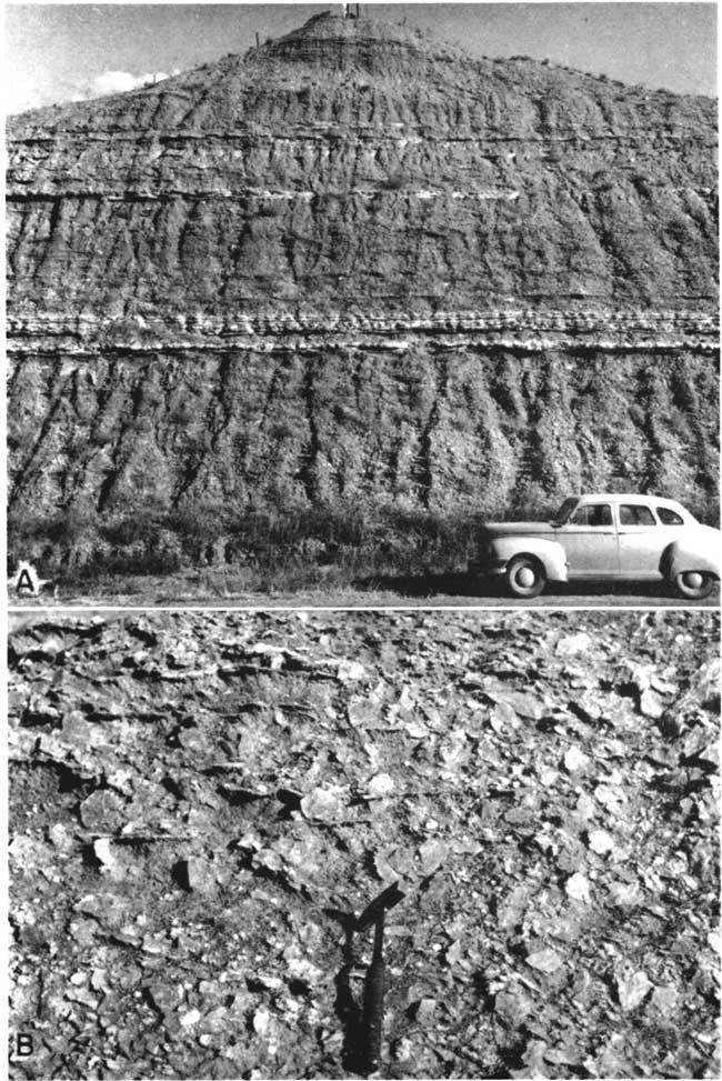
One of the most accessible and best-exposed Flowerpot sections is a U. S. Highway 160 road cut in the SE SE sec. 1, T. 32 S., R. 14 W., Barber County. The section, which is in the upper half of the formation, starts at road level; it ends 15 feet below the base of the Blaine gypsum (Pl. 10A).
| Flowerpot shale exposed along U. S. Highway 160 in the SE SE sec. 1, T. 32 S., R. 14 W., Barber County | Thickness, feet |
||
|---|---|---|---|
| Permian--Leonardian | |||
| Flowerpot shale | |||
| 10. Sandstone, very fine-grained, silty, friable, gypsiferous, pink (7.5YR7/4); forms slight ledge | 4.0 | ||
| 9. Shale, slightly silty, gypsiferous, thin-bedded, reddish- brown | 15.4 | ||
| 8. Sandstones, gypsiferous, thin (<0.5 foot), pink, interbedded with reddish-brown silty shales | 4.5 | ||
| 7. Siltstone, sandy, dolomitic, gypsiferous, white (2.5Y8/0) to pink | 0.4 | ||
| 6. Shale, gypsiferous, weak-red (2.5YR5/2) mottled gray (7.5YR6/0) | 7.3 | ||
| 5. Siltstone, sandy, light reddish-brown (5YR6/4), and intergrown gypsum (selenite and satin spar) | 0.9 | ||
| 4. Clay shale, blocky, reddish-brown (2.5YR4/4); contains numerous gypsum veins | 13.5 | ||
| 3. Siltstone, argillaceous, sandy, light greenish-gray (5G7/1); contains a few thin streaks of clay shale and clear colorless gypsum veins. Very slightly calcareous | 0.3 | ||
| 2. Sandstone, very fine, and sandy siltstone; white (5YR8/1) mottled reddish-brown; cemented with gypsum. Coarser grained at top | 5.0 | ||
| 1. Clay shale, silty, blocky to splintery, reddish-brown (2.5YR4/4); contains numerous gypsum veins | 15+ | ||
| Total | 66.3+ | ||
Although the Flowerpot consists primarily of reddish-brown gypsiferous clay, several sandy or silty zones make prominent benches. One of these benches, about 40 feet above the base of the formation, is well developed southwest of Medicine Lodge in sec. 20, T. 32 S., R. 12 W. It consists of about 1 foot of light reddish-brown gypsiferous very fine sandstone, mottled greenish-gray. Other prominent sandstone benches within 40 feet of the top of the formation crop out in canyons in sec. 19, T. 32 S., R. 12 W., Barber County. Some of the gypsiferous sandstones in the Flowerpot (e.g., a 1-foot bed 75 feet below the Blaine in the SW sec. 5, T. 32 S., R. 13 W., Barber County) are cemented with coarsely crystalline gypsum and contain numerous large crystals of clear gypsum without included sand grains.
The topmost few feet of the Flowerpot is well exposed in a road cut in the SE sec. 11, T. 31 S., R. 15 W., south of Sun City, Barber County. Although immediately below the Blaine formation, this section is notable for its small quantity of secondary gypsum.
| Upper part of Flowerpot sltale exposed in road cut in the SE sec. 11, T. 31 S., R. 15 W., Barber County | Thickness, feet |
||
|---|---|---|---|
| Permian--Leonardian | |||
| Blaine formation | |||
| 10. Gypsum, massive, white | 1+ | ||
| 9. Dolomite, hard, dense, gray | 0.2 | ||
| Flowerpot shale | |||
| 8. Clay shale, hard, noncalcareous, greenish-gray | 0.3 | ||
| 7. Clay shale, silty, reddish-brown (5YR5/4); calcareous in small pin-point areas | 0.7 | ||
| 6. Clay shale, greenish-gray | 0.2 | ||
| 5. Clay shale, noncalcareous, reddish-brown | 1.5 | ||
| 4. Clay shale, greenish-gray | 0.3 | ||
| 3. Clay shale, reddish-brown | 0.4 | ||
| 2. Covered | 2.6 | ||
| 1. Sandstone, very fine-grained, poorly sorted, light-gray (mottled reddish-brown); cemented with coarsely crystalline gypsum | 2+ | ||
| Total | 9.2+ | ||
Blaine Formation
The Blaine formation consists of about 50 feet of massive gypsum, thin dolomite, and brownish-red shale. The formation, which is divided by Norton (1939) into four members, crops out in Barber, Comanche, and Kiowa Counties. It was named by Gould (1902) from Blaine County, Oklahoma, and the type locality is in Salt Creek Canyon in northern Blaine County. It is one of the most extensive and easily traced formations of the Permian redbeds, reaching from Kansas across western Oklahoma and into the Texas Panhandle and central northern Texas.
The topmost member of the formation, the Haskew gypsum, was named by Evans (1931) from exposures near an old store in sec. 2, T. 25 N., R. 19 W., Woodward County, Oklahoma. The member consists of 1 foot or less of gypsum underlain by about 5 feet of brownish-red shale. The gypsum has been removed by solution in many places, particularly north of the Kansas-Oklahoma line, and it was not in evidence at any of the localities seen by me.
The Shimer gypsum member underlies the Haskew. This member was named by Cragin (1896, p. 27) from exposures in Shimer Township, Comanche County, Kansas, and consists of a 13- to 23-foot bed of massive gypsum overlying 0.5 to 1.5 feet of dolomite. Much of the gypsum has been removed by solution.
Underlying the Shimer is the Nescatunga gypsum member, named by Norton (1939, p. 1794) from exposures along the lower reaches of Nescatunga Creek in southeastern Comanche County. The member includes 8 feet or less of red shale overlying 2 to 8 feet of gypsum, and 8 feet or less of red shale underlying the gypsum. The Nescatunga and Shimer gypsum beds pinch out in Comanche County and are not present as far east as Barber County.
The lowermost member of the Blaine formation is the Medicine Lodge sypsum member, named by Cragin (1896) for Medicine Lodge River and the City of Medicine Lodge in Barber County. This is, in Kansas, the thickest bed of gypsum, attaining a maximum thickness of 30 feet or more. The member also includes a foot of dolomite at the base of the gypsum and grades into it. Included within the gypsum (about 10 feet above the base) are resistant lentils of massive anhydrite 10 to 12 inches in thickness.
The stratigraphy of the Medicine Lodge member in the Sun City area has been carefully summarized by McGregor (1948), and it is not discussed further here. An exposure of the Medicine Ledge gypsum and anhydrite is illustrated in Plate 11B.
Plate 11--Blaine formation. A, Upper Medicine Lodge (at stream level), Nescatunga, and lower Shimer gypsum members; sec. 32, T. 34 S., R. 16 W., Comanche County. B, Medicine Lodge gypsum member at Natural Bridge, Barber County. Note anhydrite lentil.
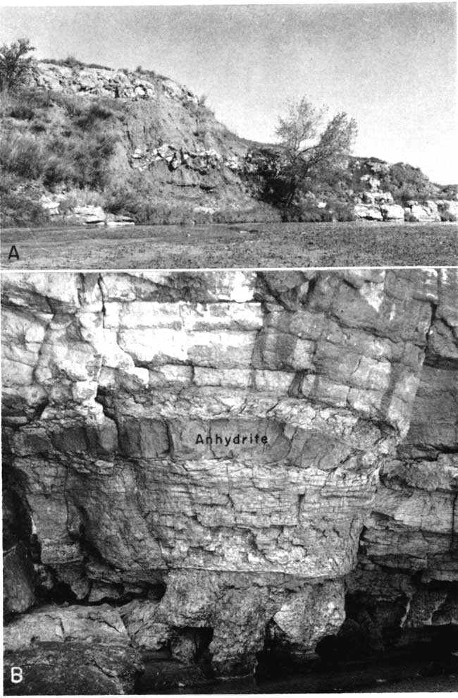
The Nescatunga and lower Shimer members are fairly well exposed in a stream bank in the NE sec. 32, T. 34 S., R. 16 W., Comanche County, along Red Ford Creek (Pl. 11A). At this locality the upper 3 feet of the Medicine Lodge gypsum is exposed just above stream level, and the interval below the Nescatunga gypsum consists of 8 feet of soft brownish-red shale with scattered crystals of impure gypsum. The gypsum of the Nescatunga member is partly dissolved and slumped, but it has a maximum thickness of 4.5 feet at this locality. Above the gypsum is 8 feet of crumbly brownish-red silty shale with occasional thin (less than 0.3 foot) streaks of brownish-red and greenish-gray mottled silty shale.
At least 15 feet of Shimer gypsum is exposed at this locality. At the base is 1.3 feet of dolomite, much of which is oolitic, the oolites consisting predominantly of dolomite and the matrix (cement) of gypsum. The upper part of the dolomite is gradational into the massive gypsum and contains many stringers or veins of clear, colorless selenite or satin spar. Part of the dolomite shows small-scale cross bedding (Pl. 12B).
The oolitic dolomite is interpreted to have been produced by agitation of shallow-water sediments by wave action in calcium-magnesium carbonate- and sulfate-saturated water. A recently published paper (Illing, 1954) describes such a locus of sedimentation in the Bahamas. Oolites in the Blaine gypsum are seemingly wide spread, for they are reported from well cuttings at several localities. An algal origin is also possible. Moore (personal communication, July 1954) notes that algal growth is favored by hypersaline conditions (for example, Great Salt Lake and Pennsylvanian and Permian regressive parts of cycles) in which dolomite may be formed.
Plate 12--A, Upper Dog Creek shale and basal Whitehorse sandstone at type locality of Dog Creek shale, Barber County. B, Cross-bedded gypsiferous oolitic dolomite at base of Shimer gypsum; sec. 32, T. 34 S., R. 16 W., Comanche County.
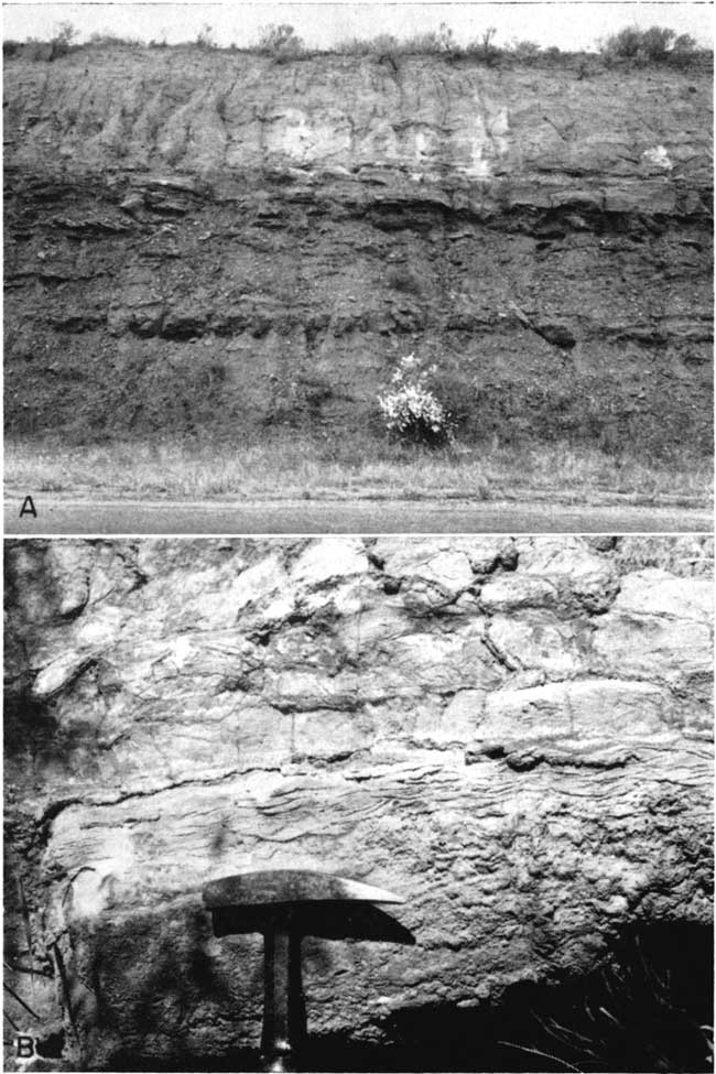
Dog Creek Shale
The Dog Creek shale is commonly grouped with the Blaine formation, for it includes all the deposits between the uppermost gypsum of the Blaine and the base of the Whitehorse sandstone. Where the three upper gypsums are missing, the Dog Creek includes the shales overlying the Medicine Lodge member. Thus the thickness is variable and is reported to range from 14 to 53 feet. The formation consists of thin beds of dark-red silty shale, brownish-red and greenish-gray siltstone, and very fine-grained sandstone, dolomite, dolomitic and gypsiferous sandstone, and gypsum. It was named by Cragin (1896, p. 40) from exposures on Dog Creek south of Lake City, Barber County (probably S. line sec. 4, T. 32 S., R. 14 W.) (Pl. 12A).
Although the Dog Creek has been classified tentatively as the topmost formation of the Leonardian Series, there is no indisputable evidence in Kansas of an unconformity separating it from the overlying Whitehorse sandstone.
The Dog Creek shale at the type locality overlies the Medicine Lodge gypsum member of the Blaine formation and is approximately 75 percent shale or silty shale. The section is given below.
| Dog Creek shale near type locality in the S2 sec. 4, T. 32 S., R. 14 W., Barber County | Thickness, feet |
||
|---|---|---|---|
| Permian--Guadalupian? | |||
| Whitehorse sandstone | |||
| 30. Sandstone, very fine-grained, friable, cross-bedded, red with large irregular white spots; contains a few thin (5 cm) calcareous sandstone lentils | 15+ | ||
| 29. Sandstone, hard, calcareous, red; contains sand balls as much as 2.5 mm diameter | 3.5 | ||
| 28. Siltstone, dolomitic and calcareous, white to red; lenticular | 0.2± | ||
| 27. Clay shale, silty, dolomitic, blocky, brownish-red | 1.8 | ||
| 26. Siltstone, dolomitic, white (5Y8/1) with discontinuous red streaks; microscope shows large chlorite flakes | 0.3 | ||
| 25. Clay shale, silty, brownish-red | 1.3 | ||
| 24. Siltstone, argillaceous, calcareous, thin-bedded, red mottled light-gray; an 11-mm layer near base contains salt casts up to 9 mm in diameter on lower side | 1.0 | ||
| 23. Clay shale, silty, blocky, dark-red | 1.4 | ||
| 22. Siltstone, hard, calcareous, light-red with white and brownish-red spots (<2 mm diameter) | 3.5 | ||
| 21. SiItstone, slabby, white; contains thin greenish-gray silty shale seams | 1.0 | ||
| 20. Clay shale, massive, reddish-brown | 4.1 | ||
| 19. Siltstone, greenish-gray mottled light-brown | 0.4 | ||
| 18. Clay shale, blocky, reddish-brown (2.5YR5/4) | 6.5 | ||
| 17. Limestone, vesicular, hard, sugary, white to red; contains many specks of black to dark-brown organic matter | 0.2 | ||
| 16. Clay shale, blocky, brownish-red | 2.4 | ||
| 15. Siltstone, massive, white, mottled light-brown | 2.2 | ||
| 14. Partly covered; chiefly brownish-red blocky silty clay shale with a few thin gray streaks | 7.8 | ||
| 13. Siltstone, slightly argillaceous, slabby, white | 0.2 | ||
| 12. Clay shale, blocky, brownish-red | 0.8 | ||
| 11. Siltstone, doIomitic, hard, uneven, light-gray | 0.1 | ||
| 10. Clay shale, silty, blocky, brownish-red | 1.9 | ||
| 9. Siltstone, calcareous, white with minute spots (<1 mm) stained brown to black by organic matter | 0.2 | ||
| 8. Clay shale, blocky, dark-red | 0.6 | ||
| 7. Siltstone, very calcareous, white (10YR8/1) with minute spots (<1 mm); stained dark-brown by organic matter | 0.8 | ||
| 6. Clqy shale, blocky, brownish-red slightly mottled light-red | 0.9 | ||
| 5. Clay shale, greenish-gray; surfaces uneven | 0.3 | ||
| 4. Clay shale, blocky, dark-red | 2.4 | ||
| 3. Clay shale, greenish-gray mottled | 0.2 | ||
| 2. Clay shale, silty, blocky, dark-red | 0.8 | ||
| 1. Covered | 5.3 | ||
| Blain formation--Medicine Lodge gypsum member | |||
| Total | 67.1 | ||
Forty-one feet of Dog Creek shale is exposed above the Medicine Lodge gypsum in the NW sec. 13, T. 30 S., R. 16 W., southeastern Kiowa County, where a section has been measured by Latta (1948, p. 120). This exposure is less than 15 miles from the type area, but individual beds in the two sections seemingly cannot be correlated. The argillaceous calcareous silty sandstone of Latta's bed 8 is a coarser grained clastic than any in the Dog Creek of the type locality, but on the other hand siltstone beds are more common in the shales of the type area.
The lower few feet of the Dog Creek is exposed in an abandoned gypsum quarry in sec. 19, T. 30 S., R. 15 W., northwestern Barber County, about 9 miles from the type area.
| Lower Dog Creek shale in abandoned gypsum quarry in sec. 19, T. 30 S., R. 15 W., Barber County | Thickness, feet |
||
|---|---|---|---|
| Permian--Leonardian | |||
| Dog Creek shale | |||
| 6. Sandstone, fine-grained, friable, calcareous, red (2.5YR5/6) with small white spots; bleached white at top | 3.5 | ||
| 5. Sandstone, silty, very fine-grained, friable, red with small white spots | 1.2 | ||
| 4. Clay shale, silty, brownish-red | 4.0 | ||
| 3. Dolomite, calcareous, argillaceous, highly vesicular, sugary, light greenish-gray (5G8/1) with brownish-red stain; in thin beds | 1.8 | ||
| 2. Clay shale, silty, brownish-red; contains thin resistant dolomitic sillstones, bleached zones, and thin (<3 inches) porous dolomite beds | 8.0 | ||
| 1. Covered | 5.2 | ||
| Blain formation--Medicine Lodge gypsum member | (4+) | ||
| Total | 23.7 | ||
Near the Oklahoma line larger quantities of sandstone occur in the upper part of the Dog Creek shale, and red- and white-banded gypsum locally marks the top of the formation. This gypsum and the underlying sandstones are exposed in a road ditch along the S. line sec. 28, T. 34 S., R. 17 W., Comanche County. The gypsum is 1.8 feet thick and is coarsely crystalline. It consists of alternating red and white bands of uniform thickness (about 0.8 to 1.3 cm) with the white bands perhaps slightly thicker than the red (Pl. 7B). The crystals of red gypsum are somewhat coarser than those of the white gypsum, and the red layers are multiple. Underlying the gypsum is at least a foot of light reddishbrown (5YR6/4) very fine-grained, luster-mottled gypsiferous sandstone with large (0.3 mm diameter) crystals of gypsum. Below the red sandstone is about 1 foot of light greenish-gray (5GY8/1) poorly sorted gypsiferous sandstone containing pink gypsum crystals as large as 22 mm in long diameter (Pl. 7C). The sandstone is predominantly fine-grained, but it also contains greenish-gray clay galls and scattered large well-rounded quartz grains 1 mm in diameter or smaller. Some of the large grains are somewhat concentrated in streaks and pockets of 3 or 4 square cm in area. This may be the "conglomeratic sandstone" of Norton (1939, p. 1800).
Prev Page--Introduction || Next Page--Stratigraphy, Guadalupian?
Kansas Geological Survey, Geology
Placed on web Aug. 25, 2006; originally published May. 1955.
Comments to webadmin@kgs.ku.edu
The URL for this page is http://www.kgs.ku.edu/Publications/Bulletins/111/03_strat.html