A LARGE-SCALE APPLICATION: The Dakota Study and the Pseudo-Seismic Approach
As near-surface ground water sources become more scarce, the Cretaceous Dakota a
quifer is becoming an important potential source of ground water for western Kan
sas. A study of the Dakota aquifer is underway in order to develop a better ass
essment of water-resource potential and planning needs of the aquifer
(Macfarlane & Sawin [4]).
The Dakota aquifer is composed of irregularly distributed sandstones of the Dako
ta and Kiowa formations and Cheyenne Sandstone. An understanding of the aquifer
's lateral extent, vertical thickness, and overall capacity across western Kansa
s is important for developing well-spacing requirements and sound resource manag
ement.
The Dakota aquifer study mainly involves using existing well log information to
achieve these goals. Because the study encompasses a large area (approx. 125,0
00 km2) and a large number of wells, alternative methods of macro-scale well lo
g analysis were examined and a method designated pseudo-seismic profiling was de
veloped (Carr, et al. [5]).
Pseudo-Seismic Profiling
Stratigraphic interpretation from wireline logs is typically drawn from multiple log traces or from crossplots of log data. Both techniques can readily depict vertical changes in lithology or reservoir quality, but lateral relationships are not easily visualized.
Significant improvement in the geologic interpretation of wireline log data can be achieved through color image transformation and treatment of the transformed data as "seismic" traces for the purposed of processing, interpretation and display (Collins & Doveton, [6]).
Such transforms can combine data from porosity, gamma and density tools generating a color coded "crossplot log" for each well.
A well-designed color transformation of wireline log data from multiple wells maximizes both spatial and compositional information content, and provides a readily interpretable image of the subsurface geology. The transformed image, in either 2-D or 3-D, can be treated as "seismic" data easing the data-handling burdens through the use of computerized techniques designed for interpretation of seismic data.
The pseudo-seismic approach to stratigraphic interpretation is based on the observation that wireline well logs resemble seismic traces in many respects. Both seismic data and wireline log data are simple x-y series, one in the amplitude-time domain and the other in the amplitude-depth domain.
Wireline well logging tools record various rock properties and output these data as a depth series. Ultimately, the goal of seismic processing is to approach on a trace-by-trace basis the resolution of geophysical well logs.
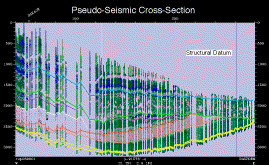
Figure 9
Structurally-datumed pseudo-seismic profile of gamma-ray logs detailing the Dakota aquifer. This profile was constructed using gamma-ray logs from over 200 wells.
A pseudo-seismic profile provides a simple representation of Permian through Cretaceous rocks of western Kansas based solely on gamma-ray logs (Figure 9). More than 200 wells were converted to SEGY format and loaded into the workstation as seismic traces.
Trace spacing was selected to be approximately 1.6 km, and wells were assigned to the nearest trace. Areas of sparse well control are represented by blank traces.
The section can be interpreted and displayed using all the tools available within the workstation environment. Using just rudimentary workstation tools results in a startling increase in interpretation speed.
Using the zoom, datum, and manual and auto-picking tools, the profile was interpreted in a few hours. Interpretations were subject to continuous verification by examination of the data set as a whole.
The display capabilities of workstation-based interpretational software increases the power of the visualization as compared to traditional computer-assisted wireline log cross-sections.
Features such as truncation of individual beds within the Permian by the Cretaceous unconformity, the effect of the dissolution of Permian salt on localizing deposition of overlying Cheyenne-Dakota fluvial sands, and normal faulting on the western margin of the Central Kansas Uplift are readily apparent (Figure 9).
The zoom and datum capabilities of the workstation can be used to map truncation, onlap, and downlap of individual "beds" within specific stratigraphic units. In terms of vertical resolution pseudo-seismic data can surpass seismic data, as vertical resolution is limited only by the resolution of the logging tool and of the digital data.


