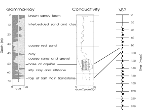
The vertical seismic profile trace from well P in relation to gamma-ray and conductivity logs is shown in Figure 4.
All of the 2-D and 3-D seismic data were collected using a downhole 30.06 rifle as a source. The end of the rifle barrel was placed approximately 0.6 m beneath the ground surface and a bullet was fired into the ground. Two common shot records were gathered and stacked at each shot location before digital archiving. Receivers consisted of three 40-Hz vertical geophones placed in an array, with receiver take-out spacings of 1.2 m. The data were recorded using a Bison 9048 seismograph with a 0.5 msec sample rate. Data processing for the seismic reflection data was performed with the SierraSEIS processing package and consisted of standard trace editing, first arrival muting, air-wave and ground roll muting, bandpass filtering, f-k filtering, velocity analysis, NMO-corrections, and stacking. The seismic reflection data were trace-balanced and loaded into the computer workstation for interpretation after stacking.
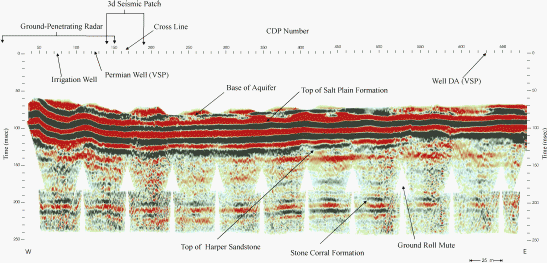
The VSP data were collected using an accelerated weight drop source. The receiver consisted of a 3-component downhole geophone. The data were recorded using a Bison 9024 seismograph with a 0.25 msec sample rate. Five common shot records were gathered and stacked at each receiver depth location before digital archiving. Data processing for the VSP data consisted of trace sorting, trace editing, wave-field separation, coherency filtering, deconvolution, static correcting, and stacking. The resulting traces were used to depth-tie the seismic reflection data at the two ground-water monitoring wells. Reflections from the base of the aquifer (51 m), and tops of the Salt Plain (69 m), Harper (104 m), and Stone Corral (195 m) formations are seen on Seismic Line One (Figure 5). All depths refer to the depths of reflectors at well P as determine by the VSP.
Seismic reflection imaging of the subsurface reveals previously unknown subsurface structure at the Siefkes Study Site. The area between wells P and DA appears to be a Permian structural low in the subsurface. In addition, the reflection from the contact between the base of the Salt Plain Formation and the top of the Harper Sandstone Formation disappears on the eastern portion of Seismic Line One. This is interpreted as destructive interference between the second peak of the Salt Plain reflection doublet and the first peak of the Harper Sandstone doublet as a result of stratigraphic thinning of the interval between the two units. The well data was insufficient to image the structural and stratigraphic variations at the Siefkes site. Such subsurface heterogeneities may be hydrologically significant in influencing the movement and concentration of Permian salt-rich brines at the site.
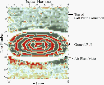
The single-fold near-surface 3-D seismic reflection data were collected in an attempt to determine the feasibility of small-scale 3-D seismic methods in near-surface studies. The 3-D seismic reflection data have a bin size of 0.6 m x 1.2 m. Although the data are only single fold and encompass a relatively small area, useful information was obtained once the data were loaded into the computer workstation and interpreted. Interpretation of the 3-D seismic reflection data was greatly enhanced by the data imaging capabilities of the workstation. Vertical and horizontal data slices were taken of the data (Figure 6 & Figure7).
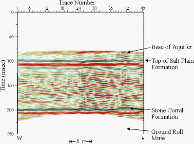
Figure 6
Vertical data slice from the northern face of the 3-D seismic reflection data volume.
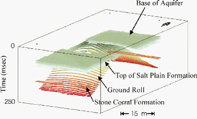
Horizon tops were selected using these data slices. The resulting horizon picks were displayed as a 3-D volume for visualization purposes (Figure 8). The reflections from the base of the aquifer, the top of the Salt Plain Formation, and the Stone Corral Formation are visible on vertical slices. The reflection from the top of the Harper Sandstone is very faint, and is visible on only a few vertical slices. The time-slice through the Salt Plain Formation reflection shows the reflection has a slight dip to the south-east, suggesting that the Salt Plain Formation may dip slightly to the south-east in the Siefkes area.
The experimental 3-D patch could be significantly improved with higher fold. The higher fold would provide greater velocity control and more reflection continuity for the 3-D data.