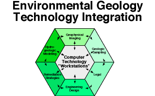
Computer workstation-based interpretational software provides the tools to handle mass quantities of data for improved site characterization. Changes in computer technologies have allowed integration of once discrete professional skills and technologies. Major computer technologies including near super computing capabilities on interactive desktop workstations, complex networking, high capacity mass storage devices, 3-D visualization software, and large digital databases. Engineers, geologists, geophysicists and other environmental professionals will more likely meet at a computer terminal than at a conference table, and communicate over the network than in formal meetings. Workstations can radically change the approach to environmental geology by integrating technology across disciplines (Figure 10). Teams will become more common-place. No longer can each discipline work on its piece of the problem use a colored pencil to put the results on a piece of paper or map, pass the results along to the next discipline, and be done with it. Large volumes of data should be accessible to and used by all the members of a team permitting reiteration in the constant process of site characterization, sample design, remediation, and policy development.
As illustrated above, near-surface geophysical methods are capable of imaging the shallow subsurface and determining the geometries of subsurface structures that affect direction and rate contaminant flow. Various two-dimensional profiles and three-dimensional volumes of environmental-oriented geophysical data along with geologic point data from wells can be brought together for an integrated interpretation within the computer workstation environment. The color display and post-stack processing capabilities of the workstation greatly enhance data interpretation, allowing small-scale to large-scale lateral near-surface heterogeneities of the alluvium and deeper bedrock structures to be successfully imaged and interpreted.