 |
|
Kansas Geological Survey Open-file Report 2003-66 |
Isopachs
|
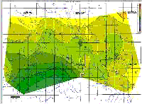
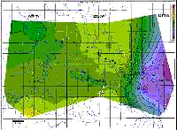
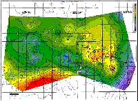
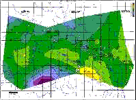
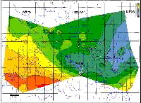
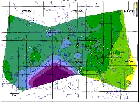
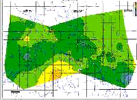
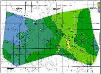
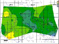
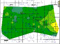
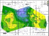
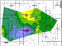
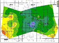
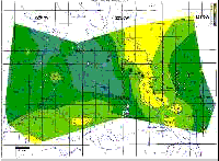
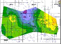
Isopach maps were created for 12 stratigraphic intervals lying between a series of Permian marker beds (Figure 4). The smaller isopach intervals represent successions of thin beds of shale, gypsum, carbonate, and halite based on core and outcrop data. Ideally, isolation of sedimentary packages such as time-distinct depositional sequences could have been used to map temporal stratigraphic changes to infer sedimentary and structural processes that caused them. However, long cores from this interval were not available to establish the depositional sequences. Thus nearly equi-spaced stratigraphic intervals between log markers were chosen for the mapping and interpretation. The salt isopachs (S3/M7-S4, S2/M6-S3/M7, and S1/M5-S2/M6) and the M4-S1/M5 isopach are discussed in detail in Watney et al. (2003). In summary, the S3/M7-S4 isopach (Figure 4A) shows only minor changes in thickness throughout the study area. There is an apparent subtle overall thinning towards the south and west, possibly due to variations in salt and shale deposition. The S2/M6-S3/M7 isopach (Figure 4B) shows little variation in thickness over most of the study area, but abrupt eastward thinning along a 1-mile-wide north-northeast trending wedge in central Hutchinson. Salt dissolution is suggested as the cause of this abrupt thinning. This dissolution edge parallels and lies approximately 5 miles west of the main dissolution front of the Hutchinson Salt. The main salt dissolution front closely corresponds to the crest of the Voshell Anticline east of Hutchinson. The north-northeast trend of the main dissolution front extends southward until the front reaches the Arkansas River, where it abruptly turns southeast following the Arkansas River to near Wichita, a distance of approximately 40 miles (Watney et al., 2003). In the area of abrupt thinning of the S2-S3 interval, the overlying S1/M5-S2/M6 isopach (Figure 4C) thickens by up to 8 ft, suggesting that the accommodation space for the upper salt bed may have been formed by early, interformational dissolution of the underlying layer prior to deposition of the S1-S2 interval. The S1/M5-S2/M6 isopach also shows abrupt eastward thinning in the eastern part of the study area, approximately 0.7 mi east of the thinning in the underlying halite interval as well as a broad, but distinctive, zone of thinning along the Arkansas River to the south and west of Hutchinson, minor thinning parallel and to the north of the Yaggy-Hutchinson anticline, and a minor north-northeast trending thin at the western edge of Hutchinson. The north-northeast trend at the western edge of Hutchinson corresponds with the edge of a tributary valley reflected in the map of the base of Equus Beds configuration (Figure 3N). These areas of northwesterly and north-northeasterly trending thinning of a halite-dominated interval are ascribed to salt dissolution, and possibly depositional thinning along the eastern edge of the study area. Depositional thinning is suggested by a concordant change in log expression suggesting an apparent facies change in the interval, e.g. from halite to gypsum to carbonate (Figure 6B). Intervening dissolution, desiccation, and minor erosion occurring between halite cycles are suggested in nearby cores and underground mines, including the mine at Hutchinson where lower portions of the Hutchinson Salt are mined. These apparent intraformational subaerial exposure events probably reflect corresponding episodic falls in sea level, exposing at least this landward edge of the evaporate basin. The marine sabkha model also predicts the landward facies change from halite to gypsum to carbonate to shale as suggested by log cross sections extending east of Hutchinson (Watney et al., 2003). An isolated thick in the S1/M5-S2/M6 isopach forms a distinctive rhombic-shaped area, centered on Hutchinson, bordered on the east by a northeasterly trending thinning due to dissolution that again parallels the Voshell Anticline, on the south by northwesterly trending thinning due to dissolution that closely follows the course of the Arkansas River, and on the west by a less distinctive zone of thinning between Hutchinson and Yaggy. The isolated thick may represent greater preservation of evaporites bounded by areas of dissolution. The M4-S1/M5 interval (Figure 4D) shows an area of thickening (approximately 6 ft) corresponding to the area of thinning (approximately 16 ft) in the S1/M5-S2/M6 isopach situated beneath the Arkansas River south and west of Hutchinson. This local elongated thickening suggests that some of the S1/M5-S2/M6 salt dissolution was early, and that the resulting accommodation space developed on the land surface was filled by deposition of M4-S1/M5. The remaining 10 ft of thinning in the S1/M5-S2/M6 isopach is interpreted to have occurred at a later time, most likely post-Permian (Watney et al., 2003). Between M4 and L2, Watney et al. (2003) display isopachs for intervals between significant markers only. These isopachs are shown in Figure 5, and can be compared with the isopachs of their subdivisions shown in Figure 4. The M1A-M4 isopach (Figure 5A) is significantly thinner in the center of the study area than to the west and southeast. Most of this variation is contained in the M3-M4 isopach (Figure 4E), particularly the thickening at the west side of the study area. A localized, circular thin, about one mile in diameter, centered on T23S R6W Sec. 10, is seen on the M2-M3 isopach (Figure 4F), but with less magnitude than for the M1A-M4 isopach, indicating that there is also subtle thinning at this location in the M3-M4 and M1A-M2 (Figure 4G) isopachs. The subdivided isopachs also reveal trends that are not observed on the composite isopach suggesting that changes are sporadic and are rapidly compensated for in superjacent strata. Thus, isopach intervals can be sufficiently large to preclude resolution of these important stratigraphic events. For instance, the M1A-M2 isopach shows a subtle band of northwest-southeast trending thinning running through the center of the study area. Within this trend, there is additional thinning in T23S R6W Sec. 3, corresponding to the location of DDV #64. It is possible that this localized thinning at DDV #64, at the center of a local structural high, is linked in some way to sudden venting of gas from DDV #64 in July 2001, six months after the initial explosions. Such localized thinning may be associated with focused dissolution of evaporites, collapse, and natural fracturing, with sufficient disruption of the stratigraphic column to carry pressured gas from one dolomite rich interval to another. The M1-M1A isopach (Figure 4H) shows a broad, subtle L-shaped thick, which runs north-south through central Hutchinson to the north of the Arkansas River, and then bends to the southeast to parallel the Arkansas River. This thick also dominates the composite Top 3-finger-M1A isopach (Figure 5B). The Top 3-finger-M1 isopach (Figure 4I) shows a subtle thin with apparently similar shape, which is located to the west of the thick in the M1-M1A isopach. The thickest part of the Top 3-finger-M1 isopach is at the western side of the study area, although there is not enough well control to uniquely define the shape of this thick. The sharp bend in the isopach trend for these intervals indicates possible structural control on sedimentation along intersecting north-south and northwest-southeast lineaments. Both the north-south, and northwesterly trends have already been identified in the S2/M6-S3/M7, S1/M5-S2/M6, and M4-S1/M5 isopach maps, with evaporite dissolution being invoked as a possible explanation for these trends of thinning. The Base Equus configuration map, depicting erosional topography of an incised valley system, shows similar north-northeasterly and northwesterly trends that may be associated with underlying structural controls, i.e., fracture/joint trends in Permian bedrock, the focus of this current study. Watney et al. (2003) relate these possible structural trends to two regional structures: the Voshell Anticline (north-south to northeast-southwest) and the Arkansas River Lineament (northwest-southeast). Fractures, subtle uplift or subsidence, and local dissolution of evaporites probably combined to create the observed patterns in these isopach maps. Episodic movement along structures may have resulted in increased fracture density, continuity, or aperture size and accordingly may have allowed undersaturated waters to come in contact with evaporites leading to locations of preferred dissolution. The L2-Top 3-finger isopach (Figure 5C) is dominated by variations in the L2-D1 isopach (Figure 4K). In contrast, the D1-Top 3-finger isopach (Figure 4J) is very uniform in thickness throughout most of the study area, except for local thickening along the eastern side of the study area. The north-northwest trending thin through the center of the study area in the L2-D1 isopach (Figure 4K) appears to have been an area of locally reduced sedimentation. The isopach map of the G2-L2 interval overlying L2-D1 shows a corresponding thickening in the same area, suggesting infilling of the previous area of thinning (Figure 4L). |
|
e-mail : webadmin@kgs.ku.edu
Last updated January 2004
http://www.kgs.ku.edu/PRS/publication/2003/ofr2003-66/isopach.html