 |
|
Kansas Geological Survey Open-file Report 2003-66 |
Detailed mapping of the Upper Hutchinson Salt and Overlying Permian strata beneath Hutchinson, Kansas
Susan E. Nissen and W. Lynn Watney
Kansas Geological Survey
Introduction
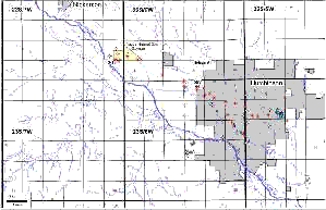 In
response to the January 2001 natural gas explosions and geysers in Hutchinson,
KS, 57 vent wells and five observation wells were drilled in the city of
Hutchinson and westward towards the Yaggy natural gas storage facility (Fig.
1), which had experienced a leak in a well, S-1, two days prior to the
explosions. At Yaggy, natural gas is stored at depths in excess of 600 ft
in solution-mined caverns in the Hutchinson Salt Mber of the Lower Permian
Wellington Formation of the Sumner Group. An estimated 143 million cubic
feet of gas escaped from a casing leak above the storage cavern, at a depth
of approximately 600 ft. Vent wells were drilled to intercept the gas and,
in all but one of the productive wells, the gas was confined to an interval
approximately 170 ft above the Hutchinson Salt, informally called the 3-finger
dolomite. The zone was named from the pattern formed by the close succession
of three low natural gamma ray intervals as seen on correlation logs, corresponding
to three thin dolomite beds as observed in core. The 3-finger dolomite is
believed to be equivalent to the Milan Limestone Member, at the top of the
Wellington Formation. DDV #64, in T23S R6W Sec. 3, is unique in that, on
July 7, 2001, it suddenly vented large amounts of gas at high pressure over
several days. This gas originated from another zone 70 ft below the 3-finger
dolomite as interpreted from gas shows and log response. This lower zone
has a series of low gamma ray beds similar to the log response of the 3-finger
dolomite.
In
response to the January 2001 natural gas explosions and geysers in Hutchinson,
KS, 57 vent wells and five observation wells were drilled in the city of
Hutchinson and westward towards the Yaggy natural gas storage facility (Fig.
1), which had experienced a leak in a well, S-1, two days prior to the
explosions. At Yaggy, natural gas is stored at depths in excess of 600 ft
in solution-mined caverns in the Hutchinson Salt Mber of the Lower Permian
Wellington Formation of the Sumner Group. An estimated 143 million cubic
feet of gas escaped from a casing leak above the storage cavern, at a depth
of approximately 600 ft. Vent wells were drilled to intercept the gas and,
in all but one of the productive wells, the gas was confined to an interval
approximately 170 ft above the Hutchinson Salt, informally called the 3-finger
dolomite. The zone was named from the pattern formed by the close succession
of three low natural gamma ray intervals as seen on correlation logs, corresponding
to three thin dolomite beds as observed in core. The 3-finger dolomite is
believed to be equivalent to the Milan Limestone Member, at the top of the
Wellington Formation. DDV #64, in T23S R6W Sec. 3, is unique in that, on
July 7, 2001, it suddenly vented large amounts of gas at high pressure over
several days. This gas originated from another zone 70 ft below the 3-finger
dolomite as interpreted from gas shows and log response. This lower zone
has a series of low gamma ray beds similar to the log response of the 3-finger
dolomite.
Most of the vent wells penetrated into the Hutchinson Salt, providing a substantial amount of new data on the distribution of the upper Hutchinson Salt and overlying layers at a high degree of spatial resolution. Natural gamma-ray logs from these wells and 59 nearby oil wells and gas-storage wells were used to conduct high-resolution stratigraphic correlation and mapping of 15 closely-spaced marker beds within the Permian strata for a 150-mi2 area encompassing Hutchinson and Yaggy. Preliminary mapping conducted as relief wells were drilled suggested patterns in structure and deposition that appeared to have influenced the migration of subsurface gas in the Hutchinson area. The work reported in this paper was undertaken later to extend the area mapped and increase the well control in order to refine the structural and stratigraphic distribution of a more finely resolved succession of stratigraphic units. The objective was to improve the understanding of the geologic history just prior to, during, and subsequent to the deposition of the 3-finger dolomite.
Ten marker beds were defined and correlated within the Ninnescah Shale and upper Wellington Formation (Fig. 2), including the top and base of the 3-finger dolomite and the M1A marker, which corresponds to the lower gas zone in DDV #64. Also, the top of the Hutchinson Salt Member (S1) and four marker beds within the upper Hutchinson Salt Member were correlated within the study area. The S2 marker is equivalent to the regional CM5 marker, and the S4 marker is equivalent to the regional CM4 marker of Watney et al. (1988). At the eastern edge of the study area, the S1, S2, and S3 salt markers correlate with thinner beds exhibiting higher natural gamma ray intensity (M5, M6, and M7, respectively), suggesting that the uppermost salt in this area may have undergone a lateral facies change associated with the depositional edge of the salt basin (Fig. 6).
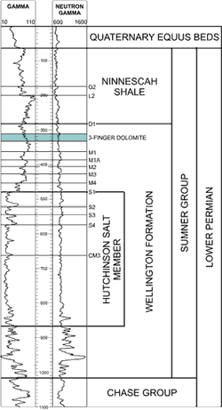 |
Figure 2. Natural gamma-ray and unscaled neutron-porosity logs from the Nelson #1 well in Sec. 34, T. 22 S., R. 6 W., showing distinctive log response of stratal members significant to study, including Lower Permian Leonardian-age Sumner Group containing the Hutchinson Salt Member of the Wellington Formation and the Ninnescah Shale, unconformably overlain by the Quaternary-age Equus Beds. Closely spaced marker beds G2 to S4 mapped in this study are shown as short horizontal lines. The regional CM3 marker bed mapped in Watney et al. (1988), which divides the upper and lower Hutchinson Salt Member, is also indicated |
| Click on poster image (below) to bring up a full size PDF format image of all maps in this report. Adobe Acrobat reader is required (24.8mb) |
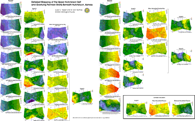 |
NotesAll maps were constructed in Petra using triangulation and a least squares gridding algorithm. When viewing figures, a seperate webpage will need to be opened. If you have a pop-up stopper program on your computer, please turn it off. Print of this report - Adobe Acrobat reader is required to view and/or print Oklahoma Geological Survey Circular 109, 2003 Evaluation of the Role of Evaporite Karst in the Hutchinson, Kansas Gas Explosions, January 17 and 18, 2001 by W. Lynn Watney, Susan E. Nissen, Saibal Bhattacharya and David Young, Kansas Geological Survey, Lawrence Kansas Click here to download a comma-delimited ASCII file containing the marker bed data used to construct structure and isopach maps. In this file, marker depths are referenced to the ELEV_KB datum. |
e-mail : webadmin@kgs.ku.edu
Last updated January 2004
http://www.kgs.ku.edu/PRS/publication/2003/ofr2003-66/index.html