Ground-Water Quality
The major objectives of the Upper Arkansas River Corridor Study were to document the fate and effects of contaminated Arkansas River flows on the aquifers in the river valley and to clearly determine the links among decreased flow in the Arkansas River, increased levels of water contamination in the aquifers, and lowered ground-water tables. In order to achieve these objectives, an understanding of the chemical characteristics and distribution of salinity in the aquifers was necessary. The information would allow determination of where and how saline waters of the Arkansas River have moved into the alluvial and High Plains aquifers in the river corridor. The data were also needed as input for conceptual and numerical models of saline water migration in the corridor. The design of the study included assessment of existing information and collection of new data on the ground-water quality of the aquifers and comparison to the chemical characteristics and variations of Arkansas River water.
Examination of existing information revealed that little was known of the vertical distribution of salinity in the unconsolidated aquifers. Therefore, the study included the selection of three locations for the installation of multi-level observation wells along the river corridor. Additional data needed in conjunction with the salinity distribution included lithology, water-levels, and aquifer tests. This would allow a comprehensive understanding of the salinity distribution and the hydrogeologic factors controlling it.
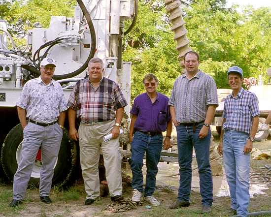
The locations of all three sites of multi-level wells are within the area in which ground waters of the alluvial aquifer or both the alluvial and High Plains aquifers have been impacted by infiltration of saline Arkansas River water. Each of the sites represents different conditions along the river corridor. The sites are located in Deerfield in eastern Kearny County, in Garden City in Finney County, and just to the west of Dodge City in Ford County. A photograph taken during the drilling of one of the wells at the Garden City site includes staff who were in the Kansas Water Office, Division of Water Resources, and KGS at the time of the picture.
Photograph taken in July 1997 during drilling of observation well no. 5 at the Garden City multi-level well site. From left to right are Glen Kirk, Al LeDoux (Director), and Gerald Hargadine (now retired) of the Kansas Water Office, Jeff Lanterman of the Division of Water Resources (now in the Kansas Department of Health and Environment), and Don Whittemore (principal investigator of the Upper Arkansas River Corridor Study).
The water samples collected and analyzed and the field measurements and tests at the sites provided data that greatly increased the understanding of the fate of saline Arkansas River water in the valley. The report Multi-Level Observation Well Sites of the Upper Arkansas River Corridor Study describes the multi-level well sites and observations, including well construction information, lithologic and geophysical logs, water levels, and water-quality data.
Another report, "Performance and Analysis of June 1998 and October 1998 Slug Tests in Kearny, Finney, and Ford Counties" by J. J. Butler, Jr. and J. M. Healey, presents the detailed results of hydraulic tests performed on the multi-level wells. The report is available from the KGS as Open-File Report No. 99-8. Information on the quality of ground waters in the Dakota aquifer in bedrock underlying the alluvial and High Plains aquifers in the river corridor can be found in the Dakota Aquifer Program pages of the KGS web site.
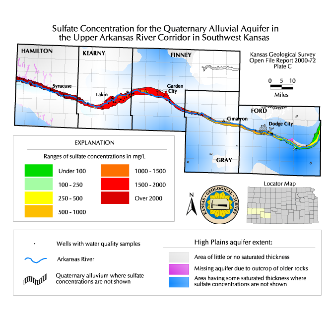
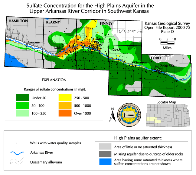
The Kansas Geological Survey analyzed samples from many irrigation and municipal wells in the Arkansas River corridor for the study. Data from the ground-water-quality network of Groundwater Management District No. 3, the database of public supply wells and the ambient network of the Kansas Department of Health and Environment, the database of the U.S. Geological Survey, and selected data from the Southwest Kansas Local Environmental Planning Group were evaluated along with the KGS water analyses for the supply wells and the multi-level observation wells to determine the current distribution of sulfate concentration in the alluvial and High Plains aquifers.
These data were also compared with earlier analyses of ground water to assess the changes in ground-water quality. In general, both the alluvial and High Plains aquifers contained much fresher water near the beginning than at the end of the 20th century. Ground water in the High Plains aquifer underlying the alluvial aquifer appears to have been fresh along the entire length of the river valley before the start of appreciable well pumping. Although some local areas of the High Plains aquifer began to be affected locally by saline river water that penetrated deeper at the cones of depression of wells, large scale infiltration of saline water into the deeper aquifer did not start until the 1970's when substantial water-level declines occurred across the corridor occurred. The saline ground water underlying the river valley and ditch irrigated areas is now migrating within the High Plains aquifer and affecting municipal supplies. The comprehensive report Ground-Water Quality of the Arkansas River Corridor in Southwest Kansas describes the water-quality changes, as well as the chemical characteristics of the ground-water and the distributions of sulfate and dissolved solids concentrations in the aquifers, and lists the analyses collected during the study and selected analyses from other agencies. Maps for the distribution of sulfate concentration in the ground waters of the corridor are available for the alluvial aquifer and the High Plains aquifer (see links below). More detail can be seen in the large maps.
- Sulfate concentration for the Quaternary Alluvial Aquifer in the Upper Arkansas River Corridor in southwest Kansas
- Small version
- Large version, Acrobat PDF file, 53 MB
- Sulfate concentration for the High Plains Aquifer in the Upper Arkansas River Corridor in southwest Kansas
- Small version
- Large version, Acrobat PDF file, 15 MB
Information from the Upper Arkansas River Corridor Study was used to assess, analyze, and interpret recharge to the High Plains aquifer in the corridor area as part of the Ogallala Aquifer Support Study for the Kansas Water Office and the Kansas Department of Agriculture. A supplementary report was written for the Ogallala study "Ground-Water Recharge in the Upper Arkansas River Corridor in Southwest Kansas."