Kansas Geological Survey, Open-file Report 2019-17
Part of the Kansas River Index Well Network project
KGS Open-file Report 2019-17
U.S. Geological Survey-Grant G17AC00170
07/01/2017 to 06/30/2019
The National Ground-water Monitoring Network (NGWMN) is an effort led by the U.S. Geological Survey (USGS) to establish a network of selected monitoring wells across the country to facilitate the planning and management of groundwater resources. The NGWMN serves as a single data portal that retrieves, in real time, construction, lithology, depth-to-water measurements, and water-quality data that are maintained and served to the portal from a variety of participating local, state, and federal sources. The NGWMN can be accessed at the following URL: http://cida.usgs.gov/ngwmn/.
In 2016, the USGS provided funding support through Cooperative Agreement G16AC00017 to the Kansas Geological Survey (KGS) to become a data provider to the NGWMN. The project period started January 1, 2016, and ended December 31, 2016. Under this agreement, the KGS evaluated monitoring sites for inclusion in the NGWMN, worked with USGS staff to populate the data portal with monitoring well sites that met a set of minimum data standards, and then developed a series of web services that allowed the NGWMN real-time data access to the state's well construction, lithology, and depth-to-water measurements records.
In 2017, the USGS provided funding support to the KGS through Cooperative Agreement G16AC00363 to maintain persistent data services to the NGWMN. This includes preserving existing web services and applying routine updates to existing network sites, which includes removing well sites that are no longer viable and uploading replacement and new well site locations. The project period started October 10, 2016, and ended September 30, 2017.
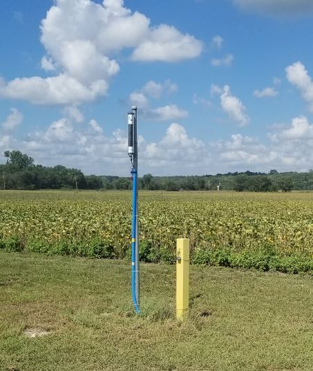
In 2018, the KGS was awarded funding from the USGS under Cooperative Agreement G17AC00170 to update the Kansas portion of the well registry, maintain the persistent data services to the NGWMN, and install a network of trend wells in the Kansas River alluvial aquifer, a stream valley in Kansas with major population growth and economic activity that lacks an active water-level observation network at the state level. This two-year project started July 1, 2017, and was completed June 4, 2019. This report serves as the final technical report for the project.
Read the PDF version (8.5 MB)
Kansas Geological Survey, Geohydrology
Placed online June 19, 2019
Comments to webadmin@kgs.ku.edu
The URL for this page is http://www.kgs.ku.edu/Geophysics/OFR/2019/OFR19_17/index.html