Kansas Geological Survey, Open-file Report 2005-34
by
P. A. Macfarlane, M. A. Townsend, and G. C. Ohlmacher
KGS Open File Report 2005-50
December 2005
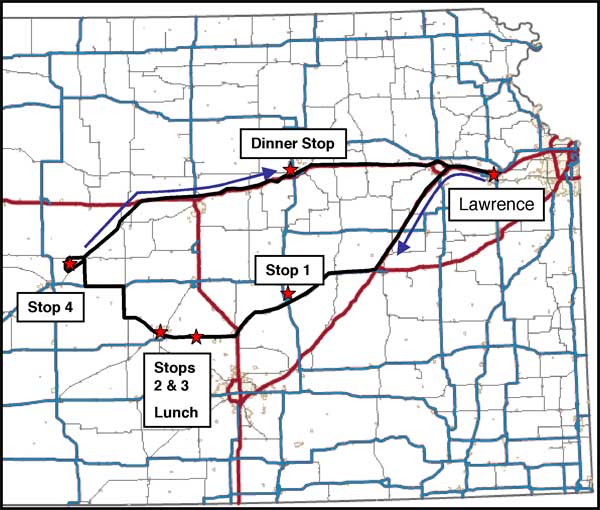
These notes pertain to a day long fieldtrip from the Kansas Geological Survey into the Flint Hills region and central Kansas with stops planned at Florence, the Hutchinson area, and Cheyenne Bottoms, just outside Great Bend (Figure 1). Lunch and dinner stops are planned at Hutchinson and the Brookville Hotel in Abilene, respectively. Should you have special needs or concerns please do hesitate to discuss them with the field-trip leaders.
Figure 1. The field trip route from the West Lawrence entrance onto Interstate 70 (the Kansas Turnpike) and return by way of the dinner stop at Abilene on Interstate 70. Stop 1 is at Crystal spring near Florence, Kansas; Stop 2 is at the IMC subsidence in Hutchinson; Stop 3 is at the US-50 and Victory Road subsidence east of Hutchinson; and Stop 4 is at Cheyenne Bottoms near Great Bend.
OFR2005_50.pdf (5 MB)
To read this file, you will need the Acrobat PDF Reader, available free from Adobe.
Kansas Geological Survey, Geohydrology
Placed online Dec. 22, 2005
Comments to webadmin@kgs.ku.edu
The URL for this page is http://www.kgs.ku.edu/Hydro/Publications/2005/OFR05_50/index.html