Kansas Geological Survey, Open-file Report 2001-05
by
Donald O. Whittemore, John M. Healey, and David P. Young
Upper Arkansas River Subbasin Water Resources Management Program
Division of Water Resources
Kansas Department of Agriculture
Agency Contract No. 1437
January 2001
KGS Open-file Report 2001-05
The contract for this investigation was funded by the Kansas Water Plan through the Subbasin Water Resources Management Program, Division of Water Resources, Kansas Department of Agriculture. Eric Hargett and Kari Eck of the Upper Arkansas River Subbasin Program of the Division of Water Resources assisted in selected of the logistics of site selection, landowner agreements, and site preparation before well installation, and measured water levels in the wells after the initial measurements. The summer students Allysa Lanier and Steve Sellwood assisted in the conductivity logging and installation of the Tate observation wells. Lawrence Hathaway and Michael Magnuson in the analytical services group of the Geohydrology Section analyzed the water samples collected from the wells. The review of Eric Hargett is appreciated and was used to edit the report.
The Division of Water Resources, Kansas Department of Agriculture (DWR) needed data on the characteristics of the alluvial and High Plains aquifers in and near the Arkansas River valley and the nature of the stream-aquifer interaction to properly manage the water resources of the Upper Arkansas River. The DWR requested that the Kansas Geological Survey (KGS) construct and log three observation wells in Kearny County, Kansas, and determine if there is a substantial hydraulic connection between the local alluvial aquifer and the Arkansas River, and between the shallow High Plains aquifer and the top part of the main High Plains (Ogallala) aquifer. Staff of the DWR (Eric Hargett) assisted in locating the sites and obtaining permission from the landowners.
Two observation wells were needed in the alluvial aquifer south of the Arkansas River in the northern half of T. 25 S., R. 38 W. The two wells were to be located so as to provide information on the water levels of the aquifer near (within a half-mile of) the Arkansas River and about one mile to the south of the river. The KGS and the DWR were to determine from the observations made during and after construction of these wells the hydraulic connection between the alluvial aquifer and the Arkansas River. Installation of these wells was to address gaps in the current network for monitoring ground-water levels. The information obtained from these two wells will be used to determine the saturated thickness and the nature of the hydraulic gradient from the river to the south. One observation well was to be located within approximately one mile of the eastern perimeter of Lake McKinney, located in the northwest corner of T. 24 S., R. 35 W. The KGS and the DWR were to determine from the observations made during and after construction of this well the hydraulic connection between the shallow aquifer and upper portion of the main Hich Plains aquifer.
The DWR assisted the KGS in locating suitable sites for the wells by contacting landowners to find parties agreeable to the installation and monitoring of the wells on their property. The KGS worked with the landowners to prepare and sign a lease agreement between the KGS and the landowners for the installation and monitoring of the wells.
Well Construction and Logs
The Kansas Geological Survey (KGS) attempted to construct two shallow wells in the Arkansas river corridor south of the Arkansas River in Sections 11 and 14, T. 25 S., R. 38 W. The objective was to provide information on the water levels of the alluvial aquifer south of the Arkansas River. Observations made during and after construction of these wells will be used to determine the hydraulic connection between the alluvial aquifer and the Arkansas River.
The KGS subcontracted with Clarke Well & Equipment to drill the wells. The drilling occurred on November 29, 1999. Bedrock was encountered at depths shallower than expected. No sianificant ground water was intercepted. Thus, the boreholes were plugoed.
A new location for the two wells was selected in the same section as for the first well drilled. The location was to the northeast in the floodplain of the Arkansas River (Sec. 11, T. 25 S., R. 38 W.). The KGS installed the wells using auger equipment on a Geoprobe. The electrical conductivity probe of the Geoprobe was first used to log the lithology of the site to determine the most appropriate depth for installation of the observation wells.
The first well in the alluvial aquifer was constructed on August 2, 2000 in the SE SE NE NE of Sec. 11, R. 35 S., T. 38 W. The location is about 0.2 mile south of the Arkansas River and 0.55 mile north of the "south river road." The electrical conductivity probe (dipole configuration) on the direct-push equipment (Geoprobe) indicated that there are several feet of clay underlain by coarse sand and fine gavel of the alluvial aquifer (Appendix A). The transition from the fine-gained sediment at the surface to the sand and gavel is sharp. The conductivity log indicated that about a foot of soft clay is present under the sand and gavel and above the competent bedrock, which was encountered at a depth of 45 ft. The well was installed to a depth of 30 ft below land surface. The casing was of 2-in PVC (10-ft sections with threaded connection) with 5 ft of screen at the bottom. The casing and screen were placed inside the hollow-stem auger flights and then the flights were removed. The top 10 ft of annular space in the well was sealed with bentonite; grout was used for most of this interval and bentonite chips were used to complete the seal to land surface. The top of the casing is 2.0 ft above land surface. A steel well protector with a lock was placed over the well. The well log and construction data form is in Appendix A.
The second well in the alluvial aquifer was constructed August 2, 2000 in the SE NE NE SE of Sec. 11, R. 35 S., T. 38 W. The location is approximately 0.4 mile south of the first well, 0.6 mile south of the Arkansas River, and 0.15 mile south of north of the "south river road." The elevation is a few feet higher than the location of the first well. The electrical conductivity probe of the Geoprobe indicated that there are several feet of clay underlain by coarse sand and fine gavel of the alluvial aquifer (Appendix A). The transition from the finegained sediment at the surface to coarse sand is sharp just as it is at the first well location. The direct-push probe hit bedrock at 50.5 ft below land surface. The well was installed to a depth of 3 3 ft below land surface. The casing was of 2-in PVC (10-ft sections with threaded connection) with 5 ft of screen at the bottom. The well was installed in a similar manner as the first well, including a steel well protector with a lock. The top of the PVC casing is 2.0 ft above land surface. The well log and construction data form is in Appendix A.
The first and second wells are desianated as Tate #1 and Tate #2. Water was pumped from Tate #1 on August 2, 2000 for 42 minutes to first develop and then sample the well. The well developed quickly (pumped at a relatively high rate for the well and the water cleared of sediment within a few minutes) due to the coarse nature of the sediments within the interval of the well screen. The pumping rate was approximately 9.4 gpm. Tate well #2 was developed on the morning of August 3, 2000. The well was first pumped for 25 minutes. After stopping for several minutes, the well was pumped for 32 minutes. The well developed quickly as did the first well. The pumping rate was about 8.6 gpm.
The thickness of the coarse portion (high hydraulic conductivity) of the aquifer was approximately the same at the two locations. The thickness was 40 ft at Tate #1 and 41.5 ft at Tate #2. The main difference in lithology between the two locations is the greater thickness of the silty clay to clay layer overlying the coarse sediments of the aquifer. The shallow bedrock along the floodplain margin one mile to the west suggests that the Quaternary alluvial aquifer is a well-defined layer of coarse sediment about 0.8-0.9 mile wide in this area.
Water-Level and Chemical Data
Water levels were measured on the morning of August 3, 2000, in both Tate #1 and Tate #2 wells. The water level in Tate #1 was 4.99 ft at the top of the casing (TOC) and in Tate #2 was 8.90 ft TOC. The difference in the water levels (3.91 ft) is approximately the same as the difference in elevation between the sites. Thus, the water-level surface is close to horizontal between the well locations. A survey of the TOC of the wells to an accuracy of at least 0.1 ft will be necessary to determine differences in the ground-water ieveis relative to the Arkansas River level. A GPS survey of the wells and of a convenient permanent marker at the Arkansas River would allow determination of flow directions in the alluvial aquifer either to or from the river. The headgates of the Amazon canal are a few hundred yards downstream of the nearest location of the wells to the river. The headgate structure could be a potential location for a point of reference to the river-water stage.
The coarse character of the sediments in the aquifer at both well locations indicates a high hydraulic conductivity for the aquifer at this location. The elevation of the bedrock surface underlying the aquifer is similar at the two well locations. The thickness of the coarse portion (high hydraulic conductivity) of the aquifer is approximately the same (40-41.5 ft) at the two sites. The main difference in lithology between the two locations is the greater thickness of the silty clay to clay layer overlying the coarse sediments of the aquifer. The shallow bedrock along the floodplain margin one mile to the west suggests that the Quaternary alluvial aquifer is a well-defined layer of coarse sediment about 0.8-0.9 mile wide in this area. The approximately 40-ft thickness of the sand and gravel zone of the aquifer and the coarse nature of the sediments in the river channel north of Tate #1 suggest that the ground-water levels should respond fairly rapidly to changes in river stage across the floodplain portion of the valley, i.e., there should be very good interaction between the river and ground water.
During the initial attempt to install wells to the southwest of the completed wells Tate #1 and #2, the KGS collected a water sample from the windmill stock well to the north of the first plugged hole location and across the "south river road." The well yields water derived from the Dakota aquifer. The results for the water analysis are in Table 1. The chemistry of the stock well water is very fresh (total dissolved solids concentration of 264 mg/L) with a sulfate content of 57 mg/L in comparison with an average of about 1,900 mg/L for sulfate in the Arkansas River during the last decade. The water quality indicates that saline water in the alluvial aquifer of the Arkansas River valley has not been able to penetrate to the interval (120-200 ft below land surface) from which water is withdrawn from the Dakota aquifer.
Table 1--Kansas Geological Survey analyses of water samples collected from the Tate observation and windmill wells.
| KGS lab number | 990341 | 000197 | 000198 |
| Project | DWR well contract | DWR well contract | DWR well contract |
| Project sample no. | UARK-411 | UARK-445 | UARK-446 |
| Collecting agency | KGS | KGS | KGS |
| Collector name | Don Whittemore | Don Whittemore | Don Whittemore |
| Sample source | Ground water | Ground water | Ground water |
| County | KE | KE | KE |
| Site name | Tate windmill well | Tate #1 observation well | Tate #2 observation well |
| Legal location | 25S-38W-11CBBD | 25S-38W-11AADD | 25S-38W-11DAAD |
| Location notes | On west side of section fence | On west side of section fence |
|
| Well depth, ft | 200 | 30 | 33 |
| Casing depth, ft | 0-120 | 0-25 | 0-28 |
| Screened interval, ft | 25-30 | 10-28 | |
| Gravel pack interval, ft | 10-30 | 10-33 | |
| Sealed interval, ft | 0-10 | 0-10 | |
| Aquifer | Dakota aquifer | Quaternary alluvial aqifer | Quaternary alluvial aquifer |
| Sample date | 11/29/99 | 8/2/2000 | 8/3/2000 |
| Sample time | 14:00 | 14:44 | 9:56 |
| Sample notes | Collected from pipe from well to stock tank | 41 min after start of pumping for development | 57 min after start of pumping for development |
| Field Sp.C., μS/cm | 450 | 3700 | 3790 |
| Lab Sp.C., μS/cm | 433 | 3610 | 3700 |
| Lab pH | 7.20 | 7.05 | 7.15 |
| SiO2, mg/L | 10.9 | 21.0 | 16.4 |
| Ca, mg/L | 53.0 | 369 | 291 |
| Mg, mg/L | 13.9 | 122 | 157 |
| Na, mg/L | 19.1 | 419 | 453 |
| K, mg/L | 2.8 | 10.0 | 9.9 |
| Sr, mg/L | 0.60 | 3.98 | 5.16 |
| HCO3, mg/L | 203 | 322 | 308 |
| SO4, mg/L | 56.7 | 1750 | 1820 |
| Cl, mg/L | 5.4 | 144 | 117 |
| F, mg/L | 0.64 | 0.61 | 0.79 |
| NO3-N, mg/L | <0. 1 | 1.3 | 1.0 |
| B, mg/L | 0.058 | 0.53 | 0.70 |
| TDS sum, mg/L | 264 | 3007 | 3026 |
The specific conductance of the well waters was monitored during pumping. The conductance remained essentially constant throughout the monitoring period for water from both Tate #1 and Tate #2 wells. The water conductance was 3,680 μS/cm after 10 minutes of pumping and remained at 3,700 μS/cm for measurements from 15 to 31 minutes of pumping at Tate #1. A water sample was collected from Tate #1 at 41 minutes after the start of pumping. The water conductance remained within the range 3,780-3,790 μS/cm for measurements during 2-19 minutes of pumping during the second pumping period for Tate #2. A water sample was collected from Tate #2 at 32 minutes after the start of the second pumping interval. The samples from both wells were filtered through a cartridge with a 0.45-μm membrane that was placed on a small flow line off the main pumping tube. The samples were collected in plastic bottles. Two bottles were collected for each sample; one was unacidified and the other was acidified with hydrochloric acid. The samples were refrigerated after collection and during transport to the laboratory. The samples were analyzed at the laboratories of the KGS.
The waters from the Tate observation wells are both saline and contain total dissolved solids (TDS) concentrations within 1% of each other (3,007 and 3,026 mg/L for Tate #1 and Tate 92, respectively, Table 1). The water from Tate #2 has a slightly greater sulfate content (1,820 mg/L) than that from Tate #1 (1,750 mg/L). In general, the chemistry of the waters from both wells is similar to that of Arkansas River water that has a TDS of about the same concentration as that of the well waters. The TDS level of the ground water is slightly less than that of the average river water during the last decade. This could reflect both the seepage of lower than average salinity water during high flows of the river into the alluvium and a small amount of dilution from recharge by meteoric precipitation.
Well Construction and Logs
The KGS installed one observation well located north of the Arkansas River within one mile of the eastern perimeter of Lake McKinney in eastern Kearny County. The purpose of the well is to determine from the observations the hydraulic connection between the shallow aquifer and upper portion of the main High Plains (Ogallala) aquifer. The well is in the SW NE SW of Sec. 8, T. 24 S., R. 35 W. (24S-35W-8CAC). The KGS subcontracted with Clarke Well & Equipment to construct the well. The borehole was drilled through 159 ft of predominantly clay and silty clay before encountering a substantial zone of sand and gravel. After drilling to a depth of 180 ft, a 20-ft screen was installed at 148-168 ft below land surface. The annular space between the casing and the borehole was sealed from a depth of 140 ft to the surface. Additional information on the well is listed in the well log in Appendix B. The observation well is identified as Bentrup #1.
After well installation, the KGS used geophysical logging equipment to produce natural gamma and electrical conductivity logs for the Bentrup observation well. The electrical conductivity log represents the lithology of the site better than the gamma log (see Appendix B). The zones with the most permeable sediment are the sand and gravel layer at 159-166 ft and the clay with gravel streaks at 144-159 ft based on the drillers log. The next most permeable zone is the clay with sand streaks at 128-144 ft. These two zones correlate well with the two intervals of the conductivity log with low values. The conductivity log displays a general decrease in values with depth. Although a small amount of this could be related to decreasing salinity of the pore waters with depth, most of the cause is probably the increase in the amount of sand and gravel lenses. The gamma log does not show as pronounced lower readings for the coarser sediments as the conductivity log. In addition, the gamma log has very high readings for a zone of lower conductivity between 60 and 70 ft. It is possible that the gamma log responded to the presence of particularly radioactive clays in the 60-70 ft zone and to radioactive feldspars in the intervals with gravel.
The Bentrup well developed into an exceptionally prolific producer of water for a 2.5-inch diameter well with a 20 ft screened interval. The pumping rate during development and sampling was approximately 35 gpm. The gravel zones intercepted by the well screen must be highly permeable. The development of the well, by air lifting, continued for two hours.
Water-Level and Chemical Data
The water level was measured on December 2, 1999 as 26.77 ft from TOC or 24.77 ft below land surface. Based on an estimated land-surface elevation of 2,987 ft at the Bentrup #1 site, the water-level elevation soon after construction was approximately 2,962 ft. That placed the ground-water level a little over 10 ft above the surface of the Arkansas River, which has an estimated elevation of 2,950 ft a little over one mile directly to the south. The water level of 17.96 ft in the well on January 25, 2001, indicates that the ground-water surface is even higher above the river than soon after the well was installed. Water in the drainage from Lake McKinney passes within a couple hundred feet west of the Bentrup observation well. The elevation of the drainage water is about 2,975 ft at a location directly to the west of the well. Thus, the water level in the well was below the surface of the drainage water at both measurement times.
The specific conductance was monitored during well development and increased only slightly (field values of 2,590 to 2,670 μS/cm) during the monitoring period of 40 min after the start of development to the end. The laboratory conductances for samples collected in the middle and at the end of the development period were essentially the same (Table 2). The temperature remained constant (15.0 deg. C) during the period. Two samples were collected from the Bentrup well. Two bottles were collected for each sample; one was unacidified and the other was acidified with hydrochloric acid. The samples were refrigerated after collection and during transport to the laboratory. The samples were analyzed at the laboratories of the KGS.
Table 2--Kansas Geological Survey analyses of water samples collected from the Bentrup observation and domestic wells.
| KGS lab number | 990343 | 990344 | 990052 |
| Project | DWR well contract | DWR well contract | NAWQA study |
| Project sample no. | UARK-413 | UARK-414 | USGS COS-1155 |
| Collecting agency | KGS | KGS | USGS |
| Collector name | Don Whittemore | Don Whittemore | NAWQA staff |
| Sample source | Ground water | Ground water | Ground water |
| County | KE | KE | KE |
| Site name | Bentrup #1 observation well | Bentrup #1 observation well | Carl Bentrup domestic well |
| Legal location | 24S-35W-8CAC | 24S-35W-8CAC | 24-35W-8CDC |
| Location notes | Center of last quarter | Center of last quarter | 8CCC on well log |
| Well depth, ft | 175 | 175 | 355 |
| Casing depth, ft | 0-148, 168-173 | 0-148, 168-173 | |
| Screened interval, ft | 148-168 | 148-168 | 315-355 |
| Gravel pack interval, ft | 140-175 | 140-175 | 20-210, 220-355 |
| Sealed interval, ft | 0-140 | 0-140 | 0-20, 210-220 |
| Aquifer | High Plains aquifer | High Plains aquifer | High Plains aquifer |
| Sample date | 12/2/99 | 12/2/99 | 4/6/99 |
| Sample time | 9:05 | 9:57 | |
| Sample notes | 65 min after start of pumping for development | 117 min after start of pumping for development | |
| Field Sp.C., μS/cm | 2630 | 2670 | |
| Lab Sp.C., μS/cm | 2500 | 2530 | 1180 |
| Lab pH | 7.80 | 7.3 | |
| SiO2, mg/L | 26.6 | 24.4 | |
| Ca, mg/L | 268 | 107 | |
| Mg, mg/L | 146 | 58.2 | |
| Na, mg/L | 152 | 67.9 | |
| K, mg/L | 10.0 | 7.11 | |
| Sr, mg/L | 7.98 | 2.99 | |
| HCO3, mg/L | 226 | 196 | |
| SO4, mg/L | 1087 | 1130 | 415 |
| Cl, mg/L | 145 | 145 | 38.7 |
| F, mg/L | 0.66 | 0.97 | |
| NO3-N, mg/L | 2.9 | 2.9 | 1.8 |
| B, mg/L | 238 | 254 | |
| TDS sum, mg/L | 2011 | 828 |
The water from the Bentrup well is saline and contains total dissolved solids and sulfate concentrations of 2,010 and 1,130 mg/L, respectively (Table 2). In Ceneral, the chemistry is similar to that of Arkansas River water that has a TDS of about the same concentration as that of the well water. However, the sodium concentration is somewhat smaller and the calcium and magnesium contents greater than for river water with similar TDS and sulfate values. The change can be explained by cation exchange of sodium for calcium and magnesium on the clays as the saline water infiltrated into the aquifer from the nearby ditches and Lake McKinney seepage at the surface. The sulfate/chloride ratio is also lower than for river water, which could reflect the infiltration of saline water affected by gypsum precipitation.
Water from the drainage west of the well location, which seeps from Lake McKinney, and in the pond downstream of the drainage had specific conductances of 5,090 and 5,110 μS/cm, respectively. This is a higher conductance than observed by the KGS in any Arkansas River water samples during 1993-2000. The higher conductance represents water that has under-one concentration of dissolved salts by evapotranspiration consumption of water. Extrapolation of the conductance-sulfate curve for Arkansas River water in southwest Kansas (Whittemore, 2000) to a conductance of 5,100 μS/cm would give an estimated sulfate concentration of 2,700 mg/L. This high a sulfate concentration would not be expected to be able to exist at equilibrium with respect to gypsum but result in some gypsum precipitation. This would lower the sulfate/chloride ratio. The resultant water would be expected to contain a larger chloride concentration than but a similar sulfate content to the most saline waters observed in the river during 1993-2000. Water concentrated by the evapotranspiration and mineral precipitation process, with a substantially lower sulfate/chloride ratio than for river water, probably has been seeping slowly to the subsurface in the area of the Bentrup #1 well for decades. The water would have mixed with fresher water in the underlying High Plains aquifer to give the ground-water composition observed in 1999.
The KGS earlier analyzed a sample of water from the Bentrup domestic well that is located about 0.3 mile to the south of the observation well. The domestic well is screened in the bottom of the aquifer and has a grout seal at 210-220 ft (Table 2) that prevents movement of ground water from shallower depths down the annular space of the borehole to the well screen. The U.S. Geological Survey (USGS) collected the sample from the domestic well as a part of their NAWQA program for characterizing the regional water quality of the High Plains aquifer in the U.S. As a part of the High Plains Aquifer Evaluation Study (a Kansas Water Plan project) for the Kansas Water Office, the KGS is cooperating with the USGS on the NAWQA project. The domestic well water is fresh but shows evidence of infiltration of river water diverted to the area. Water historically obtained ftom the lower part of the High Plains aquifer at the town of Deerfield about 3 miles to the east contained a sulfate concentration of 100-120 mg/L ftom the beginning of monitoring in 1949 up to the mid-1970's. The Bentrup domestic well water contains a sulfate content of 415 mg/L, which is within the sulfate concentration range for water now produced from the two public supply wells (wells #3 and #4) most frequently operated in Deerfield.
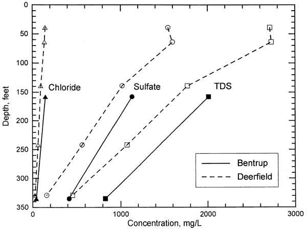
The close locations of the Bentrup observation and domestic wells allow some similar uses as for the multi-level observation wells in Deerfield installed as a part of the Upper Arkansas River Corridor Study (Whittemore et al., 2000). The depth to bedrock at the Bentrup domestic well (357 ft) is nearly the same as that at the Deerfield site (345 ft). Figure 1 displays changes in chloride, sulfate, and TDS concentrations with depths at both the Bentrup and Deerfield well locations. Both sites include predominantly clay sediments in the upper part of the High Plains aquifer and more permeable material in the lower aquifer zone. The rates of concentration increase with depth for the two dissolved constituents and TDS are very similar for the same depth intervals. The main difference is a larger concentration of chloride, sulfate, and TDS at equivalent depths in the aquifer at the Bentrup location than for Deerfield.
Figure 1--Chloride, sulfate, and total dissolved solids concentrations for the Bentrup observation and domestic wells in 24S-35W-8C and for the Deerfield multi-level observation wells in 24S-35W-11CBB. The depths to bedrock are 347 ft (Bentrup domestic well) and 345 ft (Deerfield site).
Whittemore, D.O., 2000, Water quality of the Arkansas River in southwest Kansas: Kansas Geological Survey, Open-file Report 2000-44, 85 p., for Kansas Water Office.
Whittemore, D.O., Young, D.P., and Healey, J.M., 2000, Multi-level obsernation well sites of the Upper Arkansas River Corridor Study: Kansas Geological Survey, Open-file Report 2000-42, 59 p., prepared for Kansas Water Office.
Construction and lithologic information and Geoprobe electrical conductivity logs for Tate #1 and #2 observation wells.
WWC5 and logs saved as a single Acrobat PDF file (250 kB)
Construction and lithologic information and gamma and electrical conductivity logs for Bentrup #1 observation well.
WWC5 and logs saved as a single Acrobat PDF file (250 kB)
Kansas Geological Survey, Geohydrology
Placed online Sept. 19, 2007, original report dated Jan. 2001
Comments to webadmin@kgs.ku.edu
The URL for this page is http://www.kgs.ku.edu/Hydro/Publications/2001/OFR01_05/index.html