
Updated 12-May-2004 |
THE PROJECT --- |
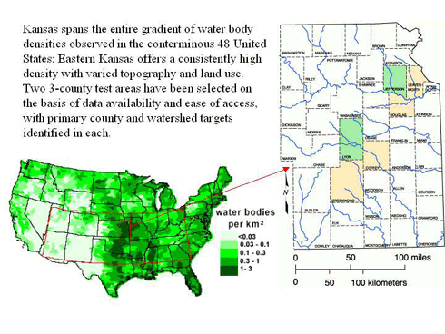
|
Kansas provides an ideal mesocosm in which to explore issues of pond detection, inventory, histories, and hydrologic and biogeochemical effects at the landscape scale. A multi-institutional interdisciplinary project is applying a combination of remote sensing, field characterization, and modeling studies to calibrate satellite observations (Landsat TM and ASTER) with multispectral and conventional aerial photography, and to evaluate the potential application of results to a wide range of water resource and environmental studies. Case study efforts focus on Jefferson and Lyon counties, with detailed investigation of the Midland and Allen SE quadrangles. Objectives of the Kansas NASA EPSCoR project are to answer the following questions:
Click to see Methods. Results confirm the under-reporting of ponds in available data sources and show similarly high densities in both the Midland (9.3/mi2; 3.5/km2) and Allen SE (8.6/mi2; 3.2/km2) quads, but historical air photos dating back to the 1940s indicate very different temporal patterns of development in the two case study areas. Spectral analysis of satellite and camera images indicates that the tools are capable of identifying a wide range of pond water quality and ecological conditions, and initial watershed spatial model analyses are being used to test and refine earlier, more general results or assumptions about the effects of ponds on the net evaporation budget, filtration effectiveness for sediment retention, and relationships between pond numbers and types and land use. In short, the project is confirming the hypothesis that small water bodies are a neglected but very important feature of the landscape, and can be both inventoried and understood in terms of their function through remote sensing and associated analyses.
|