J. A. Schloss, B. B. Wilson, R. W. Buddemeier
Boldface links are to other atlas sections; italic items are linked to glossary definitions
Definition: For long-term sustainable use of a groundwater resource, average withdrawal must be no greater than average recharge (see discussion in Recharge section for distinction between safe yield and sustainable yield). Maximum authorized use represents the amount of groundwater that could legally be pumped from a given area. Reported use tends to be less than authorized use, as shown in the section on Percent of Authorized Quantity Used. If actual use is equal to actual recharge then the resource use will be at 'safe yield.' The difference between estimated recharge and authorized use is therefore the maximum amount of change required to bring the use to, or close to, long-term sustainability. The difference between estimated recharge and actual use is a more realistic estimate of the change required to approach sustainability.
Relevance to understanding water resources: The Estimated Usable Lifetime represents the future loss of benefit that will result from continued overexploitation of the resource; reduction in current authorized (or actual) use represents the forfeiture of present benefit required to ensure more extended or permanent use of the resource at some level. Enforcing changes in authorized quantities associated with water rights is the most certain but also the most disruptive way to achieve long-term sustainability. Use of education, incentives, and agreements to achieve further reductions of actual use within the framework of existing authorizations is a slower and less certain approach, but one that is likely to be more economically, socially, and politically acceptable.
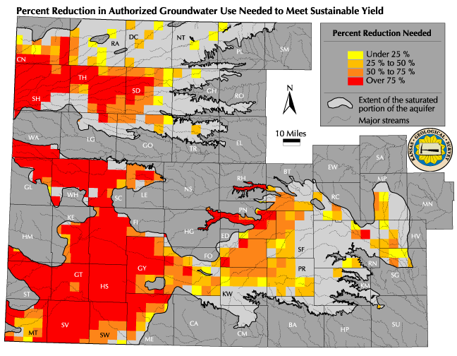
![]() Map of Percent Reduction in Authorized Use Needed
Map of Percent Reduction in Authorized Use Needed ![]() Map of Percent Reduction in Reported Use Needed
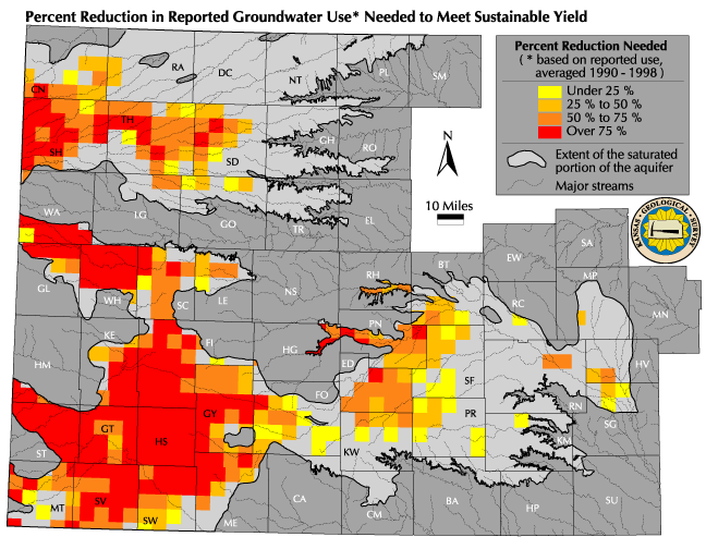
Map of Percent Reduction in Reported Use Needed
Discussion: The maps of change required for sustainability mirror to some extent the map of Current Maximum Authorized Use. Because large-scale recharge changes gradually across the region, and because actual pumping is related to authorized pumping, nonsustainability tends to track the amount and density of water rights. Because some recharge is assumed to occur everywhere, some level of sustainable use is possible throughout the aquifer system. The fraction, or percentage of use reduction required for sustainability is therefore lower in areas of low or moderate use than it is in regions with high densities of water rights. It is important to note that the apparent changes required in the 'safe yield' districts of the eastern High Plains are the result of using the natural recharge map as a basis rather than the administrative recharge map. If the recharge values defined by regulation were used, there would be very few areas of apparent overappropriation in Groundwater Management Districts 2 and 5.
The most striking feature of the two maps is the very high percentage of reduction in authorized use required to match recharge. Overall, a lower percentage reduction in actual use is required. The difference is most noticeable in northwest Kansas and in regions close to the boundary of the saturated portion of the aquifer. Although reductions in actual use of a third to a half at the township level would bring extraction to the approximate magnitude of the recharge in some areas, the core irrigation regions in southwestern and western Kansas are pumping 3-4 times the estimated long-term recharge value. The differences in the authorized and reported use patterns shows the importance of scale in considering water resource problems -- because of the natural time constants and variability of groundwater systems (see technical appendices on aquifer types and terminology and groundwater storage and flow), the aquifer, basin, or district level is too large for assessing and managing the resource, and the legal section level is too small. Townships are awkward because they are political rather than natural hydrologic units, but their size is appropriate for addressing the nature of the resource and our knowledge of its characteristics.
Sources and methods: The maximum authorized use (acre-feet per township for the current year), the average reported use for the period 1990-1998, and the maximum value of recharge (inches per year) from the natural potential recharge map intervals were converted to the same units and calculated for each township. Recharge was subtracted from use so that a positive number represents the amount of over-use (or over-appropriation). This number was then divided by the actual use (or the authorized use) to express the reduction needed as a percentage of the total actual or authorized use. As with the other maps in this atlas, values were grouped into classes to indicate the approximate range of reductions required; because of uncertainties in the details of local recharge and in the way the authorized use was calculated at the township level, this provides a reasonable overview without spurious precision.
Qualifications: Recharge values are one of the more uncertain hydrologic parameters. Use of the maximum value from each recharge class interval provides an estimated reduction that probably represents the lower end of the required reductions. However, given the uncertainties and the large and variable difference between authorized and actual use, it provides a useful estimate. The values presented here are estimates intended to provide general information on the scale of the problem and possible solutions. Although the authorized use values can be accurately determined, the reported use values are a reasonable approximation of actual use, and the recharge values are broad regional estimates that require refinement in order to establish actual local values of sustainable use. The values presented here are not specific recommendations, nor do they have any official standing in terms of policy or regulation.
See also: Current Maximum Authorized
Use, Estimated Annual Groundwater Recharge,
Estimated
Usable Lifetime
Back to Directory
Funded (in part) by the Kansas Water Plan Fund