R. W. Buddemeier, P. A. Macfarlane, G. Misgna
Boldface items are linked to other sections; italic items are linked to glossary definitions
Groundwater terminology can be confusing, in part because there are often many different terms describing the same phenomenon, and the same term can be used with different meanings. This section provides a brief summary of the general issues and an indication of the way the terms are used in this atlas, with sections on terminology, internal structure, and aquifer type.
What is an aquifer? The word literally means 'water bearer' and refers to a layer of rock or sediment that contains enough accessible water (see appendix on groundwater storage and flow) to be of interest to humans. Water in an aquifer is stored between the grains of rock. Aquifers can be either consolidated rock (such as sandstone) or unconsolidated (such as the sands and gravels that make up the High Plains aquifer. The variety of reasons for human interest create some of the differences in definition: a person seeking a municipal or irrigation well that can pump a thousand gallons per minute has a different perspective from a domestic well user who can be content with ten gallons per minute, and both have a very different perspective than a scientist interested in the migration of fluids over geologic time. Yet, all can and do call the objects of their attention 'aquifers.' In keeping with the major uses of the Kansas High Plains aquifer, we use the term to mean a body that can supply pumped groundwater at rates at least adequate for domestic water supplies, and that contains primarily potable water.
And what is not an aquifer? Two other common terms used are aquitard (which retards groundwater flow) and aquiclude (which excludes groundwater flow). These terms are also relative for the same reasons used as examples in the case of 'aquifer.' A number of similar or synonymous terms exist for these features; aquicludes are also known as confining or impermeable layers, and aquitards as semi-confining or leaky impermeable layers.
Aquifer names: Aquifers are often named for the geologic formation in which they occur -- Kansas examples include the Ogallala and the Dakota aquifers. However, the geologic formation may not be uniformly water-bearing -- the Dakota is a good example, having a greater volume of relatively impermeable units than of actual aquifer units (see http://www.kgs.ku.edu/Dakota). Aquifers (especially smaller units) are often identified by the way they were formed (e.g., alluvial aquifers are water-deposited, and glacial drift aquifers are deposited by glacial action). Because aquifer function is defined by continuity and characteristics rather than by the origin of the materials, large aquifer systems may be composed of several geologic formations. The High Plains aquifer is such a composite; in western Kansas it consists of the Ogallala formation, which in eastern Ford County grades into the more recent but very similar deposits of the Great Bend Prairie and Equus Beds aquifers. The alluvial stream and river channel deposits on the surface of the High Plains units (which are also alluvial in origin) are usually also considered part of the High Plains aquifer system when there is a good hydraulic connection between them. See also aquifer type below.
Alluvial material is deposited from water (usually flowing water) -- rapidly moving water transports and deposits coarse material (gravel and sand), which turns into permeable aquifer deposits when buried, while flood plains and lake bottoms may have thick layers of relatively impermeable silts and clays. The dimensions of alluvial features may range from a few feet to many miles in lateral extent, and from vanishingly thin to hundreds of feet in thickness. This accounts for the spatial variability of properties within an alluvial aquifer unit, and for the common complaint that "we do not have enough data." When the zone of influence of a single well is on the order of a mile (see appendix on drawdown and pumping) and the aquifer properties can vary significantly at both smaller and larger scales, precise and accurate prediction of behavior is not possible without intensive -- and expensive -- field studies.
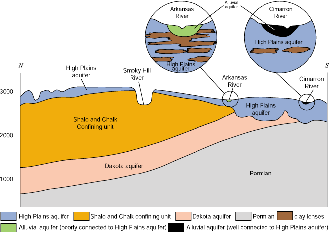
The aquifer cross-section figure illustrates some of the features common in alluvial deposits. Laterally extensive clay layers can lead to 'confined aquifer' or 'perched aquifer' characteristics.
One of the ways to deal with the problem of spatial variability is being pursued by the High Plains Aquifer Evaluation Project -- this is to use intensively studied or well characterized areas as case study sites to see how detailed information can be related to or predicted from the more general information usually available. Understanding these relationships does not provide the same level of knowledge as real measurements would, but it does improve the odds of making a valid estimate when faced with questions where the data base is sparse.
The High Plains, like most Kansas aquifers, is an unconsolidated, unconfined aquifer. Other terms similar to 'unconfined' are 'water table,' or 'phreatic,' aquifer. Some deeper water bearing units like the Dakota aquifer contain consolidated (e.g., sandstone) layers, and may be separated from the surface by confining layers impermeable enough so that the deep water can be under pressure. Breaches in the confining layer may result in a spring or artesian well flowing at the surface.
The cross section figure illustrates the occurrence of a rather extensive clay layer within the the water table aquifer below the Arkansas River. If such layers are large enough and impermeable enough, the water beneath them is said to be 'locally confined' or 'semi-confined,' and the water on top of them is said to be 'perched.' Effectively, the layer divides the aquifer into two unconnected regions which are not in flow or pressure equilibrium. Such regions occur in the High Plains; for example, areas in south-central Kansas (southwestern GMD5 and northwestern GMD2) and along the Upper Arkansas River Corridor (see Kansas aquifer section) display confined behavior. In such areas the usual relationships between water table elevation and change and the underlying water resource are not valid, so it is important to recognize the differences for effective management and monitoring.
Back to Directory
Funded (in part) by the Kansas Water Plan Fund