Last revision: 11/21/2000
- js
Back to Directory
Groundwater Storage and Flow
R. W. Buddemeier, J. A. Schloss
Boldface items are linked to other sections; italic
items are linked to glossary definitions
Groundwater Storage, Porosity, and Specific Yield: Groundwater
occupies the cracks and pore spaces between rocks and mineral grains below
the land surface. In the saturated zone, essentially all of the pores are
filled with water. If a volume of saturated aquifer material is completely
dried, the water volume removed reflects the total porosity
of the material, or the fraction of pore space within the total volume
of solids plus open spaces. This number can be surprisingly large; some
minerals and rock formations can have total porosities in excess of 50%.
In the unsaturated, or vadose, zone there can be significant amounts of
water present, but the voids are not completely filled (see appendix on
saturated
thickness).
However, some of the pore spaces may be too small or too poorly connected
to permit the water they contain to flow out easily. The effective porosity
can be thought of as the volume of pore space that will drain in a reasonable
period of time under the influence of gravity. Effective porosity is always
less than total porosity, sometimes (as in the case of clays) much less.
"Good aquifers" tend to have values of effective porosity in the range
of 10-30%, although examples of higher and lower values can be found. Figure
1 illustrates the relationship among the types of porosity and the volume
of water in storage.
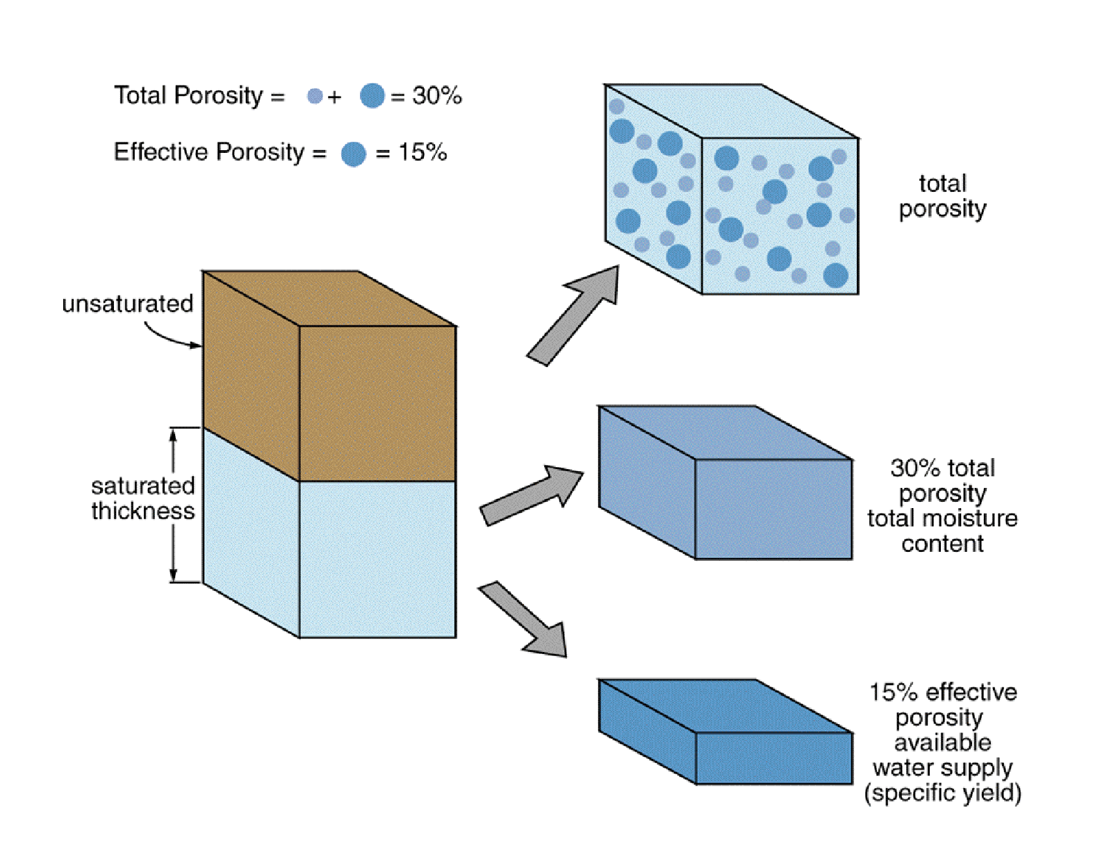
Figure 1: A schematic illustration of an aquifer in which
the total porosity in the saturated zone is 30%, half of which is tightly
held in small pores or mineral associations, and half of which is in large
pores that drain relatively easily. The latter fraction can be pumped out,
and is the effective porosity or specific yield. Illustration not to scale.
A characteristic closely related to effective porosity is the specific
yield of the aquifer, which is the volume of water per unit
volume of aquifer that can be extracted by pumping. Although there are
some technical distinctions, effective porosity and specific yield can
be thought of as equivalent for most non-technical purposes.
Specific yield (SY) is clearly an important factor in water availability,
and is the factor that is used to convert saturated thickness (ST) to the
actual volume of groundwater available;
Volume = Area x ST x SY
Figure 1 compares the water available for extraction with the total water
and aquifer volumes.
At any given location, the porosity of the formation remains essentially
constant, but the volume of water in storage, the average local porosity,
and the specific yield all vary with changes in saturated thickness (water
table elevation). Some of this variation can be explained (and quantitatively
predicted) on the basis of straightforward physical principles, but some
of it is due to local variations in the aquifer structure. This hydrogeologic
variability is difficult to predict or measure with detailed accuracy.
The US Geological Survey has prepared maps and electronic coverages
showing estimates of the distribution of Specific
Yield for the High Plains aquifer, which have been adapted for use
in this project.
Groundwater Flow and Hydraulic Conductivity: Groundwater flow
is very slow compared to surface water movement. A rough average number
often used for natural flow in the High Plains aquifer is a foot per day.
This is thousands of times slower than river flow (typically measured in
feet per second), and means that a 'parcel' of groundwater takes over a
decade to move a mile, and about a century to cross a township. This natural
time scale underscores the importance of long-term planning and management,
and helps explain why resource depletion or contamination cannot be quickly
or easily rectified.
Groundwater, like surface water, flows 'downhill' in the direction determined
by the slope of the water table. Its rate of flow is determined by
the steepness of the slope and an aquifer characteristic called hydraulic
conductivity. In a porous medium, flow is described by Darcy's
Law, an equation that relates the rate of flow to the slope (or gradient)
of the water table and the characteristics of the aquifer. This law is
illustrated in figure 2, and is written as:
Q = A x K x G,
where Q is the volume flow of water (for example, in cubic feet per day
-- also called flux), A is the vertical
area of the aquifer through which the horizontal flow is occurring, G is
the gradient or slope of the water table in the direction of flow (difference
in elevation divided by horizontal distance), and K is the hydraulic conductivity
-- a constant of proportionality that describes how easily water flows
through the medium. The term permeability
is closely related to hydraulic conductivity; in strict scientific usage
they have slightly different definitions, but for water in unconfined aquifers
they are essentially the same.
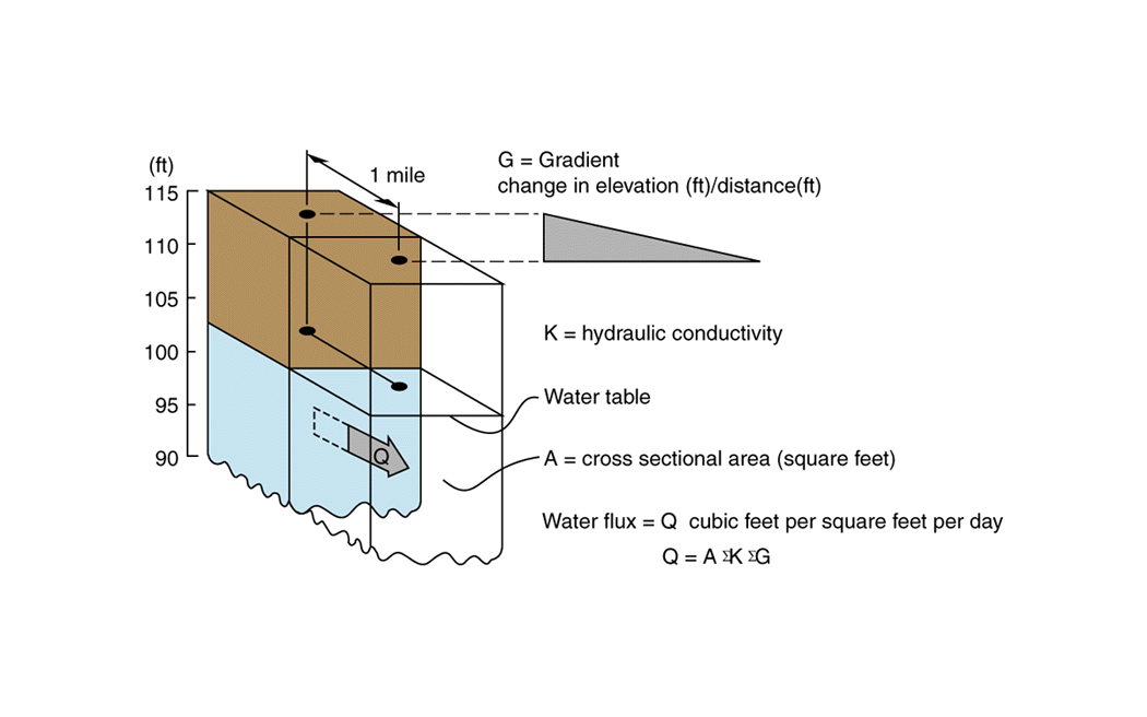
Figure 2: Illustration of the factors governing flow
in groundwater systems -- the head gradient, or slope of the water table,
the hydraulic conductivity of the aquifer, and the area through which flow
can occur.
Like specific yield, the hydraulic conductivity is related to but not
solely determined by the porosity of the aquifer. All of these characteristics
may show considerable variation over a variety of spatial scales. Because
both specific yield and hydraulic conductivity are typically measured from
tests on individual wells, their determination is relatively expensive
and applies to the scale of the zone of influence of the well -- which
is much larger than local variations in the aquifer, but very small compared
to the whole aquifer, basin, etc.
The US Geological Survey maps and electronic coverages showing estimates
of the distribution of Hydraulic
Conductivity for the High Plains aquifer have been adapted for use
in this project.
Qualifications: The USGS maps are a valuable source of aquifer
information, and represent the only consistently prepared whole-aquifer
assessment of these properties. As with all such descriptions, they suffer
from scarcity of data; measurements must be extrapolated much more broadly
than would be ideal. In addition, the analyses necessarily treat the aquifer
as a single homogeneous layer, while we know that in some areas there is
vertical stratification caused by semi-confining layers (see appendix on
aquifer
types and terminology). Unless the location is close to one of
the measurement sites, use of these coverages to describe the aquifer at
individual locations could be quite misleading. However, when considering
averages at the spatial scale of townships and larger, the data probably
represent a significant improvement over "best guess" values.
Back to Directory
If you wish to submit comments, please
include the name of the web page on which you are commenting in
your
email message.
Funded (in part) by the Kansas Water Plan Fund