J. A. Schloss, R. W. Buddemeier
Definition: Saturated thickness is the vertical thickness of the hydrogeologically defined aquifer in which the pore spaces of the rock forming the aquifer are filled (saturated) with water. The most current value is the best available estimate of the saturated thickness that would be observed if the present inventory of groundwater were undisturbed by pumping. In practice, the measurements available for constructing such estimates are months to years old, so the "most current" estimates describe the situation of the past 1-3 years. However, in most areas the uncertainty in the estimates (discussed below under Qualifications) is greater than the average annual change, so a lag of a year or two in the results does not affect their potential use.Boldface items are linked to other sections; italic items are linked to glossary definitions
Relevance to understanding water resources: Saturated thickness is a key link between the measurements that can readily be made (of changes in water-table elevation) and the changes in resources available for use. The saturated thickness times the surface area times the specific yield is equal to the volume of potentially extractable water beneath a given area of land surface -- for example, if the saturated thickness below an acre of ground is 100' and has a specific yield of 10%, the potential extractable water would be 10 acre-feet (AF) (see appendix on groundwater storage and flow). Specific yield is difficult to determine with accuracy and precision, but it typically is constant over time and varies from place to place by not much more than a factor of two. Saturated thickness is therefore commonly used as an indicator of available resources in setting management and use policies and regulations.
![]() Map of current saturated thickness
Map of current saturated thickness
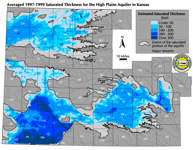
Discussion: The map of current saturated thickness shows estimates of the averaged 1997-1999 saturated thickness for the High Plains aquifer at the center of every legal section (approximately every square mile) within the area for which adequate data are available. The data limitations are not as great as for the predevelopment case, but some of the fringe areas of the aquifer cannot be accurately characterized with the available data. The classification ranges are selected to permit easy visualization of the large range of values (see Qualifications section below). The results are grouped to indicate regional average values, and cannot be used to make site-specific determinations about the resource. A saturated thickness of 30-50 feet is needed to support high-volume pumping (see appendix on drawdown and pumping). For this atlas, a value of 30 feet has been used as the target for Estimating Usable Lifetime. Anything less than 50 feet is considered a marginal area, or fringe, in terms of groundwater usable for intensive irrigation or municipal pumping. The mapped results indicate the general distribution of the remaining groundwater resources, but the map is most useful when compared to the maps of Predevelopment Saturated Thickness or of Change in Saturated Thickness. This provides a visual estimate of the change in the resource over time, and of the sustainability of past use. Groundwater Management Districts 2 and 5 in the eastern High Plains operate under safe yield policies, with groundwater appropriations limited to an administratively adopted recharge value. These areas show little change, but the Ogallala Districts (1, 3 and 4) all have substantial declines. However, the very large original inventory of groundwater in southwestern Kansas makes that area still relatively 'water-rich' in spite of declines, while in other areas, such as west-central Kansas, a much larger proportion of the total aquifer area is now in the marginal (less than 50 feet) or intermediate (50-100 feet) saturated thickness categories. Depletion causes the area of the usable aquifer to change much more rapidly that the total volume of water in storage. This change in the distribution of the relatively abundant resources affects the Accessibility and Availability of the resource for human use.
Data sources and methods:Saturated thickness estimates are based on point measurements of the bedrock elevation and of the water-table surface. Most of the data used are obtained from the annual water-level measurement program, which measures depth to water in about 1350 wells each winter. The average values for the three most recent years are used instead of the most recent year alone; this reduces the effects of measurement uncertainty (see drawdown appendix). Also, an individual well may not be measured in any one year. To make use of all of the information on bedrock elevation and water-level elevation, we calculate the differences between the water level and bedrock surfaces using a triangulation process to model the surfaces. The section-center values are then estimated from the difference between the elevations of the two modeled surfaces at that point. This process is fundamental to many water resource calculation and mapping procedures, and is described in more detail in the background information section on bedrock mapping.
Qualifications: As with all maps in this atlas, this presentation is designed to provide general information only and is not intended to be used for regulatory or management purposes, or to replace or invalidate maps that have been adopted for those purposes. The determination of current saturated thickness avoids some of the problems associated with estimates of predevelopment saturated thickness: more measurement points, of more consistent quality with a more uniform distribution are used as a basis for the current saturated thickness map, and the measurements for a given year are all made during the season of minimum evapotranspiration and pumping. However, the estimates still have significant uncertainties, in part because even the larger number of wells is less than would be necessary to see local variation. A significant additional feature is the potential failure of the measured well to achieve a water table equilibrium after the pumping season (see drawdown appendix). This, in combination with some of the natural factors shown in the saturated thickness appendix, means that there is a rather substantial uncertainty (which may vary from a few tenths of a foot to several feet, depending on location) in the absolute value of the saturated thickness for any given year. The use of a three-year average reduces this uncertainty, since it is unusual for a well to exhibit the same bias year after year. Townships and sections are typically used for management applications, but these do not necessarily match the natural scales of the hydrologic processes, the data density, or distribution of groundwater. Although the map is based on estimates made at the section level, the categories and the image of the spatial distribution of the resource are at a scale large enough to be insensitive to the known levels of uncertainty.
See also: Water in Storage, Predevelopment Saturated Thickness, Estimated Usable Lifetime
Next section: Change in Saturated Thickness
Back to Directory
Funded (in part) by the Kansas Water Plan Fund