C. D. McElwee and H. Cao
Boldface links are to other sections; italic items are linked to glossary definitions
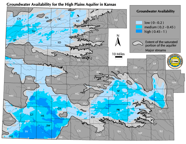
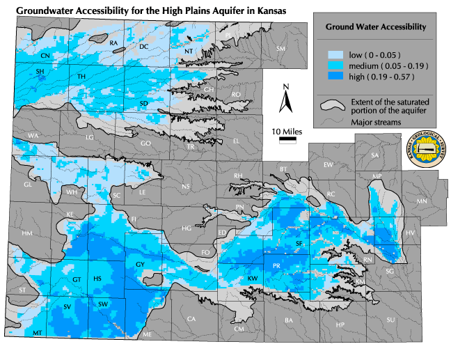
Definitions: Physical availability is the amount (volume) of water in storage beneath a given area of land surface. Accessibility is a function of saturated thickness, depth to water, and hydraulic conductivity, which is a measure of how easily water flows through or can be pumped from an aquifer. One of the general features is the use of normalized variables, which is simply a process of dividing all values of a particular map by the highest value observed, resulting in a common scale of zero to one. This standardizes and simplifies comparisons and calculations. Availability is the normalized value of Water in Storage, presented in categories or intervals. Accessibility is zero if hydraulic conductivity or saturated thickness is zero, and increases as these values increase. However, accessibility decreases as the depth to water increases. The basic definition of accessibility used here is the product of hydraulic conductivity and saturated thickness divided by the depth to water. In order to avoid the problems associated with dividing by numbers close to zero, the definition is modified by adding 1.0 to the normalized depth to water. This ensures that the accessibility function will range from 0-1. Provinces of groundwater accessibility are then defined based on selected ranges of values and displayed graphically on a map.
Relevance to understanding water resources: Clearly, if no water is available then we do not have a water resource. When volume in storage and hydraulic conductivity are both low, then an area will have low availability and accessibility. It is valuable to be able to rank a given area relative to another for groundwater availability. By using normalized current water in storage and displaying high, medium, and low availability provinces, it is possible to see at a glance how various areas compare. Accessibility of an aquifer bears directly on the description of a water resource. If water is present but unable to move easily due to low hydraulic conductivity, the value of the water resource is considerably diminished. Water at a very great depth is not as valuable as water at shallow depths, due to increased pumping lift. The accessibility function that we have defined allows one to quickly evaluate the net effect of the three most important factors affecting accessibility: hydraulic conductivity, saturated thickness, and depth to water. Although there are strong similarities in the availability and accessibility maps, there can be important differences. For example, a very deep groundwater basin might have a large volume in storage (and therefore high availability), but if hydraulic conductivity is low and depth to water great compared to other areas, this water will be much less accessible.
Discussion: Groundwater availability and accessibility have been defined so that all values will be between 0 and 1. Color coding these ranges on the maps allows provinces of high, medium, and low availability and accessibility to be shown graphically. Since the same scale is used for the entire High Plains aquifer, it is possible to compare availability in one area to availability in any other area. The values selected for the range division in this presentation have been chosen for convenience in making visual distinctions on the maps; it is easy to redefine the classes to address specific questions or problems.
![]() Map of groundwater availability
Map of groundwater availability
The values used for the availability ranges are: low (0.20-0.0), medium (0.45-0.20), and high (1.0-0.45). It should be emphasized that availability as defined here relates to the amount of water physically present and has no relation to regulatory availability. The Division of Water Resources of the Kansas Department of Agriculture has regulatory authority over whether new water rights are granted in a given area.
![]() Map of groundwater accessibility
Map of groundwater accessibility
The accessibility ranges have the same theoretical limit of 1.0, but in practice the observed maximum value for the index was much lower, so the useful numerical values of the ranges are not the same as for availability. For accessibility, the low range is 0.0-0.05, the medium range 0.05-0.19, and the high range is 0.19-0.57 (the maximum value observed). The numerical ranges are displayed graphically on the map by color coding. Again, since the same scale is used for the entire High Plains aquifer, it is possible to compare accessibility in one area to accessibility in any other area. As with availability, the ranges shown here can be modified and replotted to address specific considerations.
Data sources and methods: There is no unique scientific definition of groundwater availability and accessibility. We have defined availability and accessibility based on hydrologic principles and data available for the High Plains aquifer. The maps presented in this section are based on the amount of water in storage and the saturated thickness of the aquifer. In addition, a hydraulic conductivity map produced by US Geological Survey studies of the High Plains aquifer has been used in the accessibility calculations. Point values for depth to water at wells were used in calculations for groundwater accessibility. All values were normalized by dividing by the largest value to ensure that all values will be between 0 and 1.
Qualifications: The limitations of the water in storage and the current saturated thickness data are discussed elsewhere in this atlas but apply equally well here since those data are used in the availability and accessibility calculations. An unknown magnitude of uncertainty exists in the US Geological Survey map for hydraulic conductivity. However, it is likely that the best available data at the time were used.
As noted above, the values selected for the low-medium-high ranges were chosen for illustrative purposes and do not represent any specific management or economic considerations. The approach could easily be adapted to include such considerations.
Next section: Regional Groundwater Quality
Provinces
Back to Directory
Funded (in part) by the Kansas Water Plan Fund