Last
revision: 11/09/2000 - js
Back to Directory
Saturated Thickness -- Concepts and Measurement
R. W. Buddemeier
Boldface items are linked to other atlas sections; italic
items are linked to glossary definitions
A Close-up Definition --
The detailed figure below shows the rock and pores spaces in a volume of
the aquifer. It gives an exaggerated illustration of saturated and unsaturated
zones in an aquifer, and how those relate to the upper and lower boundaries
and to saturated thickness. See the appendix section on groundwater
storage and flow for how this relates to porosity,
specific
yield, and water volume. In the unsaturated, or vadose,
zone, addition of water by recharge
from the surface causes the water content to rise until it reaches the
field capacity of the soil -- the concentration of water at which gravity-driven
drainage flow occurs.
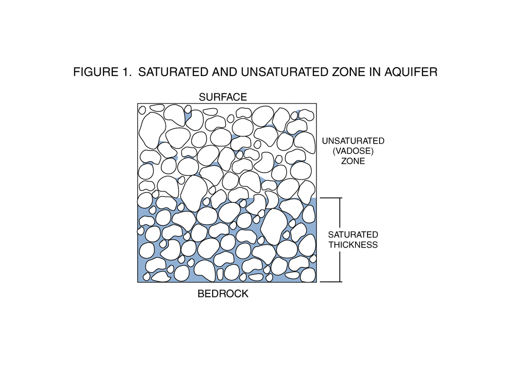
Figure 1: Saturated and unsaturated zones in an aquifer
composed of coarse, unconsolidated material. In the saturated zone, all
of the pore spaces are filled with water. In the unsaturated (also known
as the vadose zone), some water is usually present, but the amount is variable
and it is always less than the field capacity.
Under natural conditions, the elevation of the boundary between the unsaturated
and saturated zones -- the water table -- fluctuates as a function of recharge,
discharge, and evapotranspiration. These variation can be surprisingly
large, in part because of the effect of porosity in amplifying the elevation
change due to recharge. If the effective porosity of the aquifer is 17%,
for example (a common value in the High Plains), recharge of 2 inches of
free-standing water will cause the water table to rise by approximately
one foot.
The figure below illustrates the idea of saturated thickness -- that
volume of the aquifer in which the pore spaces are completely filled (saturated)
with water. At a particular point, the local saturated thickness is the
difference in elevation (or depth) between the water table and the bedrock
surface (the base of the aquifer). However, bedrock and water table elevations
are often measured at different points, and because both vary over space,
the saturated thickness at any given point must usually be estimated from
what we know about the two surfaces rather than on observed values. This
is often a more useful measure of the actual amount of underground water
than observations at a few specific points, because it provides good estimates
for a whole region instead of precise measurements at very limited locations.
Natural Condition -- No Groundwater Pumping
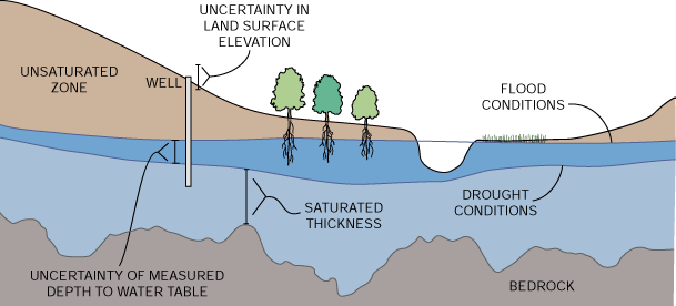
Figure 2: Saturated thickness in cross section -- the light
blue area represents the average volume of permanent saturation, and the
dark blue area is the range of variation of its upper limit, which is affected
by topography, recharge, discharge, and the effects of vegetation.
The elevation of the water table varies over time even under natural conditions.
Seasonal and year-to-year variations in recharge result in fluctuations,
and where the water table is shallow the evapotranspiration
of plants can have very significant effects during the growing season.
Estimates of saturated thickness therefore depend on the times, places
and numbers of measurements taken. Uncertainties in the absolute value
will be at least several feet and perhaps tens of feet, but adoption of
a standard set of assumptions and measurement protocols can provide an
estimate that is useful as a baseline for comparison regardless of its
accuracy.
Human Modification --
Human modification of the land surface, and especially groundwater pumping
and/or stream diversion, have even greater short-term and long-term effects
on the water table and saturated thickness. For a discussion of the effects
of pumping on short-term water table elevation changes, see the appendix
on drawdown and pumping. Long-term effects
are addressed in the atlas section on Change in
Saturated Thickness, and in the appendix on decline
rates.
Back to Directory
If you wish to submit comments, please
include the name of the web page on which you are commenting in
your email message.
Funded (in part) by the Kansas Water Plan Fund