P. A. Macfarlane, G. Misgna, and R. W. Buddemeier
Boldface links are to other atlas sections; italic items are linked to glossary definitions
An aquifer is a body of rock or sediment that contains and yields enough water to be useful to humans. Its boundaries are defined by the land surface and/or by its borders with surrounding geologic formations particularly if those borders do not contain or transmit water. The characteristics of aquifers are discussed in more detail in technical appendices on aquifer types (terminology and definitions), saturated thickness, and groundwater storage and flow.
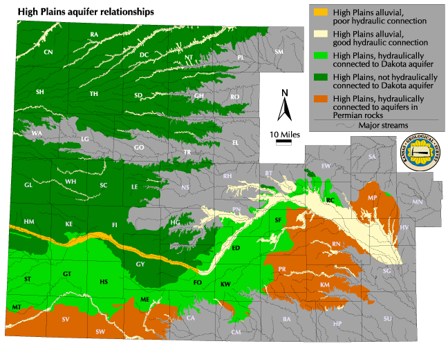
The High Plains aquifer is the most important water resource in western and south-central Kansas, an area that lacks extensive surface water and has limited precipitation. The High Plains underlies approximately 33,500 square miles of 46 counties in western and south-central Kansas and is present in seven other states in the Great Plains region of the United States. Depth below land surface to the base of the aquifer is over 500 feet in parts of southwestern Kansas. This water source consists of Pliocene to late Holocene (approximately 5 million years ago up to present day) age sediments deposited by eastward-flowing streams and by wind. These sediments consist of unconsolidated clay, silt, sand, and gravel in amounts that vary across the region. This aquifer was formerly referred to as the Ogallala aquifer in Kansas. However, the name has been changed because regional studies by the US Geological Survey have shown that other geologic units as well as the Ogallala form this aquifer. The purpose of this section is to identify the various aquifers in the region and describe their interaction with the High Plains aquifer.
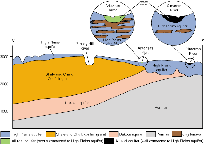
Other aquifers are hydraulically connected to the High Plains aquifer. An aquifer is hydraulically connected to an overlying or underlying aquifer if water can move easily between them. Poor hydraulic connection exists when the aquifers are separated by low permeability sediment or rock layers. In the extreme, an aquifer is isolated hydraulically from another if they are separated by thick, low-permeability sediment or rock layers. The other aquifers present in the High Plains region include the alluvial, the Dakota, and those within Permian rock units. The map and cross-sectional view of the subsurface show the aquifer distributions in relationship to the High Plains aquifer.
The alluvial aquifers overlie the High Plains aquifer and consist of unconsolidated sediments deposited by rivers in the stream valleys (see map). In southwest Kansas, hydraulic connection between the Arkansas River alluvial aquifer and the underlying High Plains aquifer is poor because low permeability clay layers inhibit the downward flow of groundwater (see cross-sectional view). Thus, the upper Arkansas River alluvial aquifer is a perched aquifer. However, the Cimarron River alluvial aquifer is well-connected to the underlying High Plains aquifer because there are no clay layers immediately beneath the alluvium to inhibit the flow of groundwater between the aquifers.
The Dakota aquifer consists of sandstones that were deposited in ancient river valleys and along shorelines during the Cretaceous Period (approximately 100 million years ago) and underlies much of the western two-thirds of Kansas. In southwest and south-central Kansas, the Dakota underlies and is in good hydraulic connection with the High Plains aquifer (see map and cross-sectional view). To the north, a thick sequence of low permeability shale and chalk hydraulically isolates the Dakota from the High Plains aquifer. As a result, the High Plains aquifer interacts very little if at all with the Dakota over most of its extent. Further information on the Dakota aquifer can be found at http://www.kgs.ku.edu/Dakota.
The aquifers in Permian rocks consist of sandstones that were deposited along shorelines and in shallow bays during the Permian Period (approximately 250 million years ago) and underlies all of the western two-thirds of Kansas. In most areas, the water in these aquifers is too saline for human use. Where the Dakota is not present to separate them, these bedrock aquifer units are in good hydraulic connection with the overlying High Plains aquifer (map and cross-sectional view). This allows the upward movement of saltwater from the dissolution of naturally occurring salt in south-central Kansas Groundwater Management Districts (GMDs) No. 2 and No. 5, and beneath the Cimarron River valley in southwestern Kansas GMD3 (see Regional Groundwater Quality Provinces section).
Next section: Predevelopment Saturated Thickness
Back to Directory
Funded (in part) by the Kansas Water Plan Fund