![]()
Prev Page--Geography || Next Page--Ground Water
Geology
Summary of Stratigraphy
[Note: The classification and nomenclature of the rock units described in this report follow that of the State Geological Survey of Kansas as of publication date and differ somewhat from the classification and nomenclature of the U. S. Geological Survey.]
The rocks that crop out in Wallace County are sedimentary in origin and range in age from Cretaceous to Recent. Their areal distribution is shown on Plate 1; their stratigraphic relations are illustrated on cross sections on Plate 2. A generalized section of the outcropping rock units is given in Table 4.
Table 4--Outcropping rocks of Wallace County and their water-bearing properties.
| System | Series | Stratigraphic unit |
Maximum thickness, feet |
Physical Character | Water supply |
|---|---|---|---|---|---|
| Quaternary | Pleistocene | Alluvium | 70 | Stream-laid deposits ranging in composition from clayey silt to coarse sand and gravel occur along principal stream valleys. Thick, coarse deposits occur in the basal part of major valleys; finer deposits occur in smaller valleys. | Yields moderate to large quantities of water to wells in South Fork and North Fork Smoky Hill Valleys, moderate to small amounts in the smaller tributary valleys. Yields are as much as 1,000 gpm to irrigation in the major valleys. |
| Peoria and Loveland Formations |
50 | Silt, mostly eolian, becoming sandy in lower part; locally contains a thin bed of gravel rubble near the base. Mantles most of the uplands, particularly in the southern part of the county, and masks much of the valley walls. Locally includes colluvial deposits in draws and headwaters of tributary streams. | Most of the deposits are above the water table, and hence yield no water to wells. In areas where ground-water supplies are meager, colluvial deposits overlying bedrock in small upland creeks and draws serve as local catchment basins from which small amounts of ground water are available. | ||
| Tertiary | Pliocene | Ogallala Formation |
400 | Chiefly sand, gravel, silt, and clay; largely unconsolidated but cemented to various degrees in places by calcium carbonate and locally by silica. The deposits are interbedded and admixed in various proportions, sand and limy silt being the dominant constituents. | Yields moderate to large quantities of water to wells in the southern and extreme western and northwestern parts of the county, and moderate to small quantities of water in much of the rest of the county. Yields are as much as 2,000 gpm to irrigation wells. |
| Cretaceous | Upper Cretaceous | Pierre Shale |
600± | Fissile dark-gray shale, clayey and fossiliferous. Concretions of varied size and composition occur in zones, usually along bedding planes; thin beds of mottled grayish-green and brown bentonite are common. Iron pyrite and marcasite occur in fresh exposures; limonite and selenite crystals characterize weathered exposures. | Yields no water to wells. |
| Smoky Hill Chalk Member of Niobrara Chalk |
650± | Gray and light-gray chalk and chalky shale, thin bedded and platy. Contains thin beds of bentonite. Weathers to bright orange and cream yellow. | Yields no water to wells. |
The Smoky Hill Chalk Member, upper member of the Niobrara Chalk of Late Cretaceous age, is the oldest rock unit exposed in Wallace County. The Smoky Hill Chalk Member crops out along the south side of the South Smoky Hill Valley in the extreme east-central part of the county; in the rest of the county it is buried beneath younger rocks.
The Pierre Shale of Late Cretaceous age conformably overlies the Smoky Hill in Wallace County and crops out in the central and northern parts of the county. The Pierre is the dominant bedrock and is exposed chiefly along the valley walls of the larger streams, along the streambeds of the smaller streams, and in some of the upland draws.
The Ogallala Formation of Late Tertiary (Pliocene) age unconformably overlies the Pierre Shale in Wallace County. The Ogallala is present in approximately two-thirds of the county, and in the southern part of the county it underlies most of the upland plain. Erosion has removed much of the Ogallala along the streams in the central and northeastern parts of the county, and in much of these areas the Ogallala caps only the uplands.
Thin, dissected and isolated deposits of sand and gravel of Pleistocene age occur along the larger streams, chiefly the South Smoky Hill and North Smoky Hill Rivers. These deposits have been derived from the Ogallala Formation and lithologically are very similar to the Ogallala. Because of this similarity it is difficult to distinguish the Pleistocene gravels from the Ogallala. In general, however, the Pleistocene deposits tend to be better sorted and are not admixed with finer clastics, as is characteristic of the Ogallala.
Eolian silts of Late Pleistocene age mantle much of Wallace County and are shown on the geologic map (Pl. 1) as the Peoria and Loveland Formations. Colluvial deposits, consisting chiefly of reworked loess, but in many places containing sand and gravel derived from the Ogallala Formation and local bedrock fragments, constitute much of the thin surficial deposits on the slopes of the stream valleys and in the upland draws in the central and northeastern parts of the county. Where these deposits are thick enough to conceal the underlying rocks, they have been included with the Peoria and Loveland Formations in this report.
Alluvium believed to be Recent and late Wisconsinan in age occurs along the principal streams and constitutes the youngest geologic deposits in the county.
Cretaceous Rocks Not Exposed
Several rock units do not crop out in Wallace County but lie within a possible drilling depth for water wells.
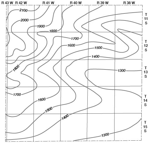
The Dakota Formation of Early Cretaceous age is an important aquifer in some areas of Kansas and may be a potential source of small amounts of ground water in Wallace County. Generalized contours indicating the depth of the Dakota Formation below land surface in Wallace County are shown in Figure 5. So far as is known, no water wells have been drilled to the Dakota Formation in Wallace County.
Figure 5--Generalized contours showing depth to Dakota Formation below land surface in Wallace County. Interpolated from structural map of Dakota Formation by Merriam (1957) and from logs of oil and gas test wells. Contour interval 100 feet.
The Graneros Shale and Greenhorn Limestone of Late Cretaceous age overlie the Dakota Formation. The Graneros Shale consists of about 60 feet of dark-gray clayey shale. The Greenhorn consists of about 100 feet of thin, alternating beds of chalky limestone and calcareous shale. Neither the Graneros Shale nor the Greenhorn Limestone can be considered an important source of ground water in Wallace County.
The Carlile Shale of Late Cretaceous age overlies the Greenhorn Limestone. The lower part of the Carlile consists of light-gray chalky shale; the upper part consists of dark-gray clayey shale. The Codell Sandstone Member, uppermost member of the Carlile, in much of Kansas consists of a thin bed of silty fine-grained sandstone. Although the Codell tends to increase somewhat in thickness in the subsurface westward across Kansas, it is not considered an important source of ground water in Kansas except in local areas near outcrops, where small yields are characteristic. No wells derive water from the Codell in Wallace County.
The Fort Hays Limestone Member, lower member of the Niobrara Chalk, overlies the Carlile Shale. The Fort Hays Member consists of grasyish-white chalk and chalky limestone beds separated by thin chalky shale partings. The Fort Hays is about 50 to 60 feet thick and ranges from about 900 feet below land surface in the southeastern part of the county to about 1,700 feet below in the northwestern part.
Prev Page--Geography || Next Page--Ground Water
Kansas Geological Survey, Geology
Placed on web July 9, 2007; originally published November 1963.
Comments to webadmin@kgs.ku.edu
The URL for this page is http://www.kgs.ku.edu/General/Geology/Wallace/04_geol.html