![]()
Prev Page--Geology || Next Page--Hydrology
Geologic Formations and their Water-bearing Properties
Paleozoic Rocks
Permian System--Upper Permian Series
Big Basin Formation
In the subsurface of Grant and Stanton counties the red beds below the last known usable water-bearing sandstone are correlated with the Upper Permian Big Basin Formation (Norton, 1939, P. 13; O'Connor, 1963, p. 1875-1877). Merriam (1957. fig. 6) shows a geologic map of the inferred areal geology in pre-Triassic time. A basin is indicated by successively older beds outcropping away from the center of the structure.
Distribution and thickness--Both Grant and Stanton counties were shown to be underlain by the Big Basin Formation (Merriam, 1957). Moore and others (1951, p. 34) discussed Upper Permian rocks in the subsurface in nearby Morton County and gave a thickness of 160 feet for the Big Basin (Taloga) Formation. The lower boundary of the Big Basin Formation was not delineated in the study.
Character--M.R. Mudge recognized the Big Basin (Taloga) Formation in southeastern Colorado and northwestern Oklahoma (McKee and others, 1959). He stated (p. 2): "This formation consists largely of dark-red mudstones with some beds of orange-red siltstone. Locally it contains some fine-grained sandstone and sandy mudstone."
The contact between the Big Basin Formation and the Upper Triassic Dockum Group can be placed with accuracy by use of drill-hole samples and radioactivity logs. Without drill-hole samples, the upper contact of the Big Basin is less certain, and the greater radioactivity of the red beds of the Big Basin is the criterion used for the separation of the Big Basin from the overlying Dockum Group.
During Neogene time streams eroded through the Cretaceous and Triassic rocks in southeastern Grant County, and in this area the unconsolidated Neogene alluvium lies directly upon the Big Basin Formation. This contact can be determined from electric and radioactivity logs with the aid of drill-hole samples. The cross sections on Plates 3, 5, and 7 show this upper contact of the Big Basin.
Water supply--No wells obtain water from the Big Basin Formation.
Table 2--Summary of geologic information from logs of gas and oil tests.
| Company | Well name | Location | Type of log (1) |
Age of bedrock present (2) |
Altitude of lsd, feet |
Sandstone | Base of Pliocene | Base of Pleistocene | |||
|---|---|---|---|---|---|---|---|---|---|---|---|
| Thickness, feet |
Depth to base, feet |
Depth, feet |
Altitude, feet |
Depth, feet |
Altitude, feet |
||||||
| T. 27 S., R. 36 W. | |||||||||||
| W. B. Osborn | Phelps No. 1 | Center sec. 6 | E | Kc or Trd | 3,089 | 705 | |||||
| Columbian Fuel Corp. | Lizzie Hoffman "B" No. 2 | SE NW sec. 16 | GR | Kd?, Kk, Kc, Trd? | 3,130 | 130 | 750 | ||||
| T. 27 S., R. 37 W. | |||||||||||
| Northern Natural Gas Producing Co. | Thorp "C" No. 1 | SW NE sec. 5 | GR | Kk, Kc, Trd | 3,079 | 170 | 665 | ||||
| Northern Natural Gas Producing Co. | Waechter "A" No. 2 | NE SW sec. 6 | GR | Kd?, Kk, Kc, Trd | 3,075 | 150 | 680 | ||||
| T. 27 S., R. 38 W. | |||||||||||
| Western Natural Gas Co. | Dora D. Wright A-U No. 1 | NW SE sec. 5 | GR | Kd, Kk, Kc, Trd | 3,178 | 170 | 515 | ||||
| Western Natural Gas Co. | R. E. Cox Unit No. 1 | SW NE sec. 24 | S | Unknown | 3,086 | 640 | |||||
| T. 27 S., R. 39 W. | |||||||||||
| Stanolind Oil and Gas Co. | Fegan No. 1 | Center sec. 3 | S | Kd, Kk, Kc, Trd | 3,244 | 280 | 620 | 70 | 3,174 | ||
| T. 27 S., R. 40 W. | |||||||||||
| Graham Michaelis Dr. Co. | Plummer "C" No. 1 | SE NE sec. 10 | GR | Kd, Kk, Kc, Trd | 3,221 | 250 | 685 | 275 | 2,946 | ||
| Graham Michaelis Dr. Co. | Plummer "A" No. 1 | SE NW sec. 11 | GR | Kd?, Kk, Kc, Trd | 3,226 | 140 | 605 | ||||
| Graham Michaelis Dr. Co. | Plummer "B" No. 1 | NE SE sec. 15 | GR | Kd?, Kk, Kc, Trd | 3,217 | 140 | 630 | 325 | 2,892 | ||
| United Producing Co. | Baughman No. 2 | SE SE sec. 16 | GR | Kk, Kc, Trd | 3,255 | 140 | 630 | ||||
| United Producing Co. | Winger No. 1 | SE SE sec. 20 | E | Kd, Kk, Kc, Trd | 3,268 | 170 | 620 | ||||
| T. 27 S., R. 41 W. | |||||||||||
| United Producing Co. | M. G. Raney No. 1 | NW SE sec. 24 | E | Kk, Kc, Trd | 3,284 | 160 | 620 | ||||
| United Producing Co. | Carl Lane No. 1 | SW NE sec. 25 | GR | Kk, Kc, Trd | 3,321 | 200 | 640 | ||||
| T. 27 S., R. 43 W. | |||||||||||
| Van Grisso Oil Co. | Wilson No. 1 | SE SE sec. 11 | E | Kd, Kk, Kc, Trd | 3,529 | 380 | 750 | 265 | 3,264 | 175 | 3,354 |
| T. 28 S., R. 35 W. | |||||||||||
| Columbian Fuel Corp. | Beaver No. 1 | SW SE sec. 15 | S | Kk,Kc | 120 | 740 | |||||
| Columbian Fuel Corp. | Kennedy A-2 | SE NW sec. 17 | GR,E | Kk, Kc, Trd | 3,082 | 130 | 755 | ||||
| W. B. Osborn | Coke No. 1 | SW NE sec. 36 | E | Kk, Kc | 3,027 | 30 | 690 | 550 | 2,477 | ||
| T. 28 S., R. 38 W. | |||||||||||
| Stanolind Oil and Gas Co. | Fletcher No. 1 | Center sec. 20 | GR | Kd, Kk, Kc, Trd | 3,118 | 190 | 620 | 370 | 2,748 | ||
| T. 28 S., R. 40 W. | |||||||||||
| Graham Michaelis Dr. Co. | Plummer "D" No. 1 | NE NE sec. 5 | GR | Kd, Kk, Kc, Trd | 3,290 | 200 | 625 | 345 | 2,945 | ||
| Ed Swearer | Plummer No. 1 | NE SW sec. 10 | GR | Kd, Kk, Kc, Trd | 3,250 | 200 | 595 | 310 | 2,940 | ||
| T. 28 S., R. 41 W. | |||||||||||
| Musgrove Dr. Co. | Craig No. 1 | Center SW sec. 10 | GR | Kk, Kc, Trd | 140 | 575 | |||||
| T. 29 S., R. 35 W. | |||||||||||
| United Producing Co. | J. W. Baughman No. 1 | SW NE sec. 13 | GR | Kc, or Trd | 3,017 | 60 | 670 | 590 | 2,427 | 500? | 2,517? |
| United Producing Co. | C. N. King No. 3 | SE NW sec. 19 | GR | Kc or Trd | 3,017 | 40 | 635 | 585 | 2,432 | 510 | 2,507 |
| United Producing Co. | R.R. King No. 1 | NE SW sec. 22 | GR | Kc or Trd | 2,999 | 20 | 655 | 630 | 2,569 | 470 | 2,529 |
| T. 29 S., R. 37 W. | |||||||||||
| Hugoton Production Co. | Eichenberger No. 2 | SE NW sec. 27 | GR | P | 3,053 | 0 | 555 | 555 | 2,498 | ||
| T. 29 S., R. 38 W. | |||||||||||
| Stanolind Oil and Gas Co. | Sullivan "B" | SW NE sec. 1 | GR | Trd? | 3,086 | 90? | 550 | 450 | 2,637 | ||
| Stanolind Oil and Gas Co. | McGannon-Snow Inc. No. 1 | Center sec. 5 | E | Trd? | 3,149 | 90? | 610 | ||||
| T. 29 S., R. 40 W. | |||||||||||
| Kansas-Nebraska Natural Gas | Ray No. 1 | SW SE see.17 | E | Trd | 3,307 | 120 | 600 | 470? | 2,837 | ||
| Kansas-Nebraska Natural Gas | Jones No. 1 | NW SE sec. 26 | E | Trd | 3,251 | J30 | 600 | 445 | 2,806 | ||
| T. 29 S., R. 42 W. | |||||||||||
| Coronet Oil Co. | Troutman No. 1 | NE NE sec. 22 | E | Kd?, Kk, Kc, Trd | 3,495 | 260 | 610 | ||||
| Sun Ray Mid-Continent Oil Co. | Santa Fe No. 1 | NW NW sec. 31, | E | Kd?, Kk, Kc, Trd | 3,566 | 230 | 565 | ||||
| T. 29 S., R. 43 W. | |||||||||||
| Anderson-Pritchard Oil Corp. | Stewart Unit "E" No. 1 | NW NE sec.28 | E | Kd?, Kk, Kc, Trd | 3,567 | 250 | 500 | ||||
| T. 30 S., R. 35 W. | |||||||||||
| United Producing Co. | Brollier No. 1 | NE SW sec. 5 | GR | P | 2,919 | 510 | 510 | 2,409 | 300 | 2,619 | |
| United Producing Co. | F. H. Truesdale No. 1 | SE NW sec. 12 | GR | P | 2,986 | 0 | 580 | 580 | 2,406 | 436 | 2,550 |
| United Producing Co. | D. Julian No. 1 | NW NE sec. 26 | GR | P | 2,845 | 0 | 412 | 412 | 2,433 | 250 | 2,595 |
| United Producing Co. | L.L. Gilbert No. 1 | SW NE sec. 31 | GR | P | 2,928 | 0 | 440 | 440 | 2,488 | 250 | 2,675 |
| T. 30 S., R. 36 W. | |||||||||||
| United Producing Co. | C. Koenig No. 2 | NE SW sec. 11 | GR | P | 3,001 | 0 | 595 | 595 | 2,406 | 300 | 2,701 |
| United Producing Co. | H. H. Thurow No. 1 | SE NW sec. 20 | GR | P | 2,999 | 580 | 580 | 2,419 | 305 | 2,694 | |
| T. 30 S., R. 37 W. | |||||||||||
| Hugoton Production Go. | R. G. Dunne No. 7 | NW SE sec. 13 | s | p | 3,040 | 0 | 517 | 517 | 2,523 | ||
| Saturn Oil and Gas Co. | Brollier No. A-1 | SW NE sec. 25 | GR,S | P | 3,005 | 0 | 514 | 514 | 2,491 | 350 | 2,655 |
| Anadarko Production et al. | NE NE sec. 32 | GR,S | Trd | 3,071 | 75 | 540 | 465 | 2,606 | 345 | 2,726 | |
| T. 30 S., R. 38 W. | |||||||||||
| Hugoton Production Co. | Bell No. 1 | NE SW sec. 21 | GR | Trd | 3,124 | 115 | 525 | 410 | 2,714 | ||
| T. 30 S., R. 39 W. | |||||||||||
| Stanolind Oil and Gas Co. | Citizens State Bank Unit No. 1 | SW NE sec. 26 | GR | Trd | 3,134 | 100 | 475 | 366 | 2,768 | 315 | 2,819 |
| T. 30 S., R. 40 W. | |||||||||||
| Kansas Natural Gas, Inc. | Plummer No. 1 | SW NE sec. 2 | E,S | Kc, Trd | 3,216 | 110 | 590 | 450 | 2,811 | 210 | 3,006 |
| Kansas Natural Gas, Inc. | Peppercorn No. 1 | NE SW sec. 3 | E | Kc, Trd | 3,274 | 180 | 590 | ||||
| PetroIeum, Inc. | Newsome No. 1 | NW SE sec. 9 | E | Trd | 3,289 | ? | 500? | ||||
| T. 30 S., R. 41 W. | |||||||||||
| Wm. Greenewald | Tucker No. 1 | SE SE sec. 29 | S | Kk, Kc, Trd | 3,421 | 240 | 530 | 195 | 3,226 | 105 | 3,216 |
| T. 30 S., R. 42 W. | |||||||||||
| Huber Corp. | Kilgore No. 2 | NE SW sec. 5 | S | Kd, Kk, Kc, Trd | 240 | 510 | |||||
| Killman-Hurd and Sun Oil Co. | Rorick Unit No. 1 | SW SW sec. 18 | S | Kd, Kk, Kc, Trd | 250 | 550 | |||||
| Huber Corp. | Sparks No. 1 | NE NE sec. 34 | S | Kd, Kk, Kc, Trd | 250 | 550 | |||||
| T. 30 S., P,. 43 W. | |||||||||||
| Shell and Sohio | Hume Unit No. 1 | SE SE sec. 23 | S | Kd, Kk, Kc, Trd | 3,570 | 230 | 480 | 110 | 3,460 | ||
| 1. E, electrical log; GR, Gamma-ray log; S, sample log. | |||||||||||
| 2. Kd, Dakota Formation; Kk, Kiowa Shale; Kc, Cheyenne Sandstone; Trd, Dockum Group; P, Permian. | |||||||||||
Mesozoic Rocks
Triassic System--Upper Triassic Series
Dockum Group
Rocks assigned to the Dockum Group, of Upper Triassic age, are found in the subsurface throughout most of the Grant-Stanton area below Cretaceous and Neogene rocks (Pl. 3-7). The nearest outcrops of the Dockum Group are to the south along the Cimarron River in Morton County (McLaughlin, 1942; Merriam, 1963) and in Baca County, Colorado (McLaughlin, 1954). Sandstone and siltstone samples collected from drill holes in the Grant-Stanton area were correlated with the samples from outcrops at Point of Rocks, Morton County, on the basis of similar lithology. Latta (1941, p. 66) recognized the occurrence of Triassic sedimentary rocks in Stanton County, stating, "The subsurface evidence in Stanton County and the relative nearness of areas of outcrop indicate that Triassic (?) beds are probably present beneath most or all of the county." Further indication of this occurrence is shown by the geologic cross sections (Pl. 3-7) and Table 2 of this report. The base of the combined sandstone sequence normally indicates the base of the Dockum Group.
A large basin in eastern New Mexico and western Texas with its eastern edge lying in southwestern Kansas is shown on an interpretative map by McKee and others (1959, pl. 9). This map shows clearly a westward thickening of Triassic sediments in the Grant-Stanton area.
What is classified in this report as Dockum may include deposits of Jurassic age equivalent to the Entrada Sandstone and the Morrison Formation.
Distribution and thickness--The Dockum Group underlies most of the Grant-Stanton area. The maximum known thickness of the Group is 130 feet in western Stanton County. The average thickness, as shown by radioactivity logs, is 90 feet. The depth of occurrence of the sandstone sequence of the Dockum Group is shown on Table 2. The base of the sandstone beds in most places represents the base of the Dockum Group. In southeastern and in parts of eastern Grant County, Pliocene and/or Lower Cretaceous deposits rest upon the Permian Big Basin Formation.
Character--The sandstones are yellow, white, pink, and tan, fine- to medium-grained, generally quartzose, and loosely cemented with calcium carbonate. Some thin beds are cemented with silica and would be classified as orthoquartzites. Red siltstone and mudstone are interbedded with the sandstone. Where drill-hole samples were available, the siltstone, mudstone, and sandstone beds of the Dockum Group can be differentiated from those in the overlying Cheyenne Sandstone of Early Cretaceous age and from the underlying Big Basin Formation. As previously mentioned, with the aid of drill-hole samples from test wells, rocks of the Dockum Group can be identified on electric and radioactivity logs.
Water supply--The Dockum Group yields water to wells in parts of Grant and Stanton counties. One well, in sec. 24, T. 29 S., R. 42 W., was reported to produce 1,000 gpm. This well is screened in both the Cheyenne Sandstone and the Dockum Group; therefore, the yield of the individual formations is not known. Other wells in northern Grant and Stanton counties probably are deriving part of their production from the Dockum Group (Tables 16 and 17).
Cretaceous System--Lower Cretaceous Series
Cheyenne Sandstone
The Cheyenne Sandstone of Early Cretaceous age does not crop out in the Grant-Stanton area. The nearest outcrop is in Baca County, Colorado (McLaughlin, 1954), where the Cheyenne is the lower member of the Purgatoire Formation. Latta (1946) discussed the Cheyenne Sandstone at its type locality in the Belvidere area, Kiowa County.
Distribution and thickness--The thickness of the Cheyenne Sandstone is variable, owing to its deposition upon an uneven pre-Cretaceous erosional surface. In the Grant-Stanton area, the thickness of the formation, where it has not been eroded by Neogene streams, ranges from 40 to more than 120 feet (Pl. 3-7). The Cheyenne Sandstone and the sandstones in the Dockum Group (Upper Triassic), although differing in age, have similar hydrologic characteristics and are considered a single hydrologic unit. The sandstone beds of the Dakota Formation [L.(?) Cretaceous] are separated stratigraphically from the Cheyenne by a dark-gray to black silty shale believed to be the Kiowa Shale. The combined thicknesses of the sandstones (Dakota, Cheyenne, and Dockum Group) were interpreted from electric and radioactivity logs (Table 2).
Character--The Cheyenne Sandstone, as described from well cuttings from Grant and Stanton counties, consists of white to rust colored, fine- to coarse-grained quartzose sandstone. The sandstone locally is poorly cemented with calcium carbonate and limonite. Pyrite is disseminated in some of the sandstone beds. The black silty shale lenses which are commonly interbedded with the sandstone make separation of the Cheyenne from the overlying Kiowa Shale difficult.
Water supply--Many wells that produce from the Cheyenne Sandstone are multiple-screened and produce water from the unconsolidated Pliocene and Pleistocene deposits as well as from the Lower(?) Cretaceous Dakota Formation and the Lower Cretaceous Cheyenne Sandstone. In some areas of Stanton County multiple-screened wells produce water from the Cheyenne Sandstone and the sandstone beds of the Dockum Group. Where the Cheyenne Sandstone consists predominately of sandstone beds, well yields up to 500 gpm are possible. In adjacent Baca County, Colorado, yields in excess of 1,000 gpm from the Cheyenne Sandstone Member were reported by McLaughlin (1954, p. 98).
Kiowa Shale
The Kiowa Shale does not crop out in Grant or Stanton counties. It is exposed along major stream valleys in southwestern and northwestern Baca County, Colorado (McLaughlin, 1954), where it is the upper member of the Purgatoire Formation of Early Cretaceous age. The Kiowa Shale at the type locality in Kiowa County, Kansas, has been described in detail by Latta (1946). The term Kiowa, as used in this report, refers to the black shale interval separating a thick sandstone believed to be Cheyenne from an overlying thick sandstone assigned to the Dakota Formation.
Distribution and thickness--The Kiowa Shale underlies most of the Grant-Stanton area. In southern and eastern Grant County, the Kiowa has been eroded by Pliocene and Pleistocene streams and is missing in some localities.
The maximum thickness of the Kiowa Shale is approximately 150 feet, as illustrated by cross sections on Plates 3-7.
Character--The Kiowa Shale consists of a dark-gray to black silty shale containing calcareous shale lenses and interbedded sandy siltstone, fine sandstone, and "soft," tan calcareous shale. Interpretations of electric and gamma-ray logs show that the Kiowa consists of shale with a few siltstone and sandstone beds. Where the Kiowa Shale consists predominantly of sandstone beds, it is difficult to distinguish from the underlying Cheyenne Sandstone or the overlying sandstone beds of the Dakota Formation.
Water supply--The Kiowa Shale yields little water to wells in the area. In some localities sandstone beds in the Kiowa are screened in some multiple-aquifer wells.
Dakota Formation
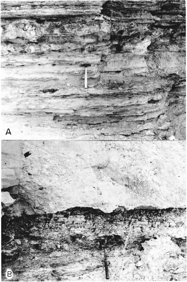
The Dakota Formation of Early(?) Cretaceous age is the oldest rock exposed in the Grant-Stanton area (Pl. 1). The formation crops out in western Stanton County along the South Fork of Bear Creek in T. 29 S., R. 43 W. and along Sandy Arroyo in T. 30 S., Rs. 42-43 W. (Pl. 8A). An angular unconformity at the Pliocene(?)-Dakota contact in Stanton County is exposed in the SW sec. 15, T. 29 S., R. 43 W. (Pl. 8B). Latta (1941) introduced the name "Cockrum Sandstone" for the rocks exposed in these localities. The Cockrum Sandstone was considered as the upper formation of a proposed Dakota Group. The lower formations were to be the Kiowa Shale and the Cheyenne Sandstone. Waite in 1942 (p. 135-137) discussed the reasons for further use of the Dakota Formation as a valid stratigraphic unit. Plummer and Romary (1942) considered the Cockrum Sandstone to be equivalent in part to the Dakota Formation of central Kansas.
Plate 8--A, Dakota Formation in SE sec. 15, T. 29 S., R. 43 W.; B, Unconformity at Pliocene(?)-Dakota contact in SW sec. 15, T. 29 S., R. 43 W., Stanton County.
Merriam (1957), in a subsurface study in Kansas, used the term "Omadi Formation" (of Condra and Reed, 1943) in place of the Dakota Formation. In the Nebraska portion of the Denver basin, the Omadi Formation is divided into Cruise Sandstone (lower), Huntsman Shale, and Gurley Sandstone (upper) members. Merriam recognized three divisions of the Omadi Formation in the subsurface and correlated them with the named members in Nebraska.
Insufficient subsurface data are available to confirm correlation of the Dakota Formation in Grant and Stanton counties with the Omadi Formation as defined by Condra and Reed (1943) and as adopted by Merriam (1957). The term "Dakota Formation," which is well established by local usage, therefore, is retained. The age of the Dakota Formation is placed as latest Early(?) Cretaceous (Table 2) as given by Jewett (1959). McLaughlin (personal communication, 1962) reported that mollusks of Early Cretaceous age similar to those found in the Duck Creek of Texas were collected near the west line of sec. 20, T. 29 S., R. 44 W., Baca County, Colorado, approximately 20 miles west of the Stanton County line. Although fossils were not found in beds of the Dakota Formation in the area of this report, the proximity to the fossiliferous outcrop in Baca County indicates that an Early Cretaceous age is probable for rocks assigned to the Dakota Formation in Stanton County.
Distribution and thickness--The Dakota Formation underlies all of Stanton County and the western half of Grant County, but it is absent in eastern Grant County. The Dakota Formation is thickest in the western half of Stanton County and on the upthrown (north) side of the Bear Creek Fault in Grant and Stanton counties (Pl. 3-7). The thickness (as indicated by sample logs) ranges from 60 to 135 feet.
Character--The Dakota Formation in most areas consists of fine- to medium-grained reddish-brown to yellowish-brown ferruginous sandstone, containing yellow and gray silty shale beds. The predominance of hydrous iron oxide as the primary cementing agent is a distinguishing feature of the Dakota Formation in Grant and Stanton counties. Minor amounts of calcium carbonate and silica cement are present. The most distinctive markers are the interbedded thin ironstone layers, which form small resistant ledges on the outcrops of the Dakota Formation.
As stated previously, the Dakota Formation can be separated from the Kiowa Shale in the subsurface by use of samples and electric and radioactivity logs; however, some sandstone classed in this report as Dakota actually may be Kiowa. The Dakota Formation has been eroded and redeposited by Neogene streams, forming sediments that in some localities are difficult to differentiate from the Dakota Formation in the subsurface. However, rounded ironstone pebbles from beds in the Dakota, when associated with material from other sources, differentiates the secondarily derived material from the Dakota Formation. Smith, who first reported this problem, stated: "Pebbles of Dakota ironstone, for example, occur well up in the Ogallala so that the presence of ferruginous chips in cuttings does not necessarily indicate that the drill has reached the Dakota Formation."
Water supply--No irrigation wells are screened solely in the Dakota, as yields from this formation range only from 50 to 100 gpm. Many wells are screened in more than one aquifer and usually obtain water from the unconsolidated Pleistocene and Pliocene deposits and from the Dakota Formation, the Cheyenne Sandstone, and the sandstones of the Dockum Group. However, there are many stock and domestic wells screened in the Dakota Formation in northwestern Grant and northern and western Stanton counties.
Cenozoic Rocks
Neogene System
Summary of Pliocene and Pleistocene Investigations
Thick deposits of Pliocene and Pleistocene age are widespread in southwestern Kansas, and they are particularly well developed in the Grant-Stanton area. The Pliocene deposits have not been divided in this report (Fig. 4). and the term "Ogallala Formation" has been used for all deposits of Pliocene age penetrated by drilling. Semicontinuous lithologic units in the Ogallala Formation have been recognized, but these units have not been successfully correlated over the entire area. In Meade County where the Pliocene deposits crop out, they have been divided on the bases of lithology and fossil content (Hibbard, 1953, 1958; Hibbard and Taylor, 1960) into three units which, in ascending order, are: Laverne Formation, Ogallala Formation, and Rexroad Formation (Fig. 4).
Figure 4--Classification of Neogene deposits in Grant and Stanton counties as compared with classification used in Meade County.
| This report | Meade County (after Hibbard, 1953, 1958, and Hibbard and Taylor, 1960) |
||||||
|---|---|---|---|---|---|---|---|
| Cenozoic Era |
Neogene System |
Pleistocene Series |
Upper Pleistocene |
Recent | |||
| Wisconsinan | Sanborn Group |
Vanhem Formation | |||||
| Sangamonian | Kingsdown Formation | ||||||
| Illinoisan | |||||||
| (Pearlette Ash bed) Lower Pleistocene |
Yarmouthian | Meade Group |
Crooked Creek Fm. |
Atwater Member (Pearlette ash lentil) Stump Arroyo Member |
|||
| Kansan | |||||||
| Aftonian | Ballard Fm. |
Missler Member | |||||
| Nebraskan | Angell Member | ||||||
| Pliocene Series |
Ogallala Formation |
Upper | Rexroad Formation X I Member |
||||
| Middle | Ogallala Formation | ||||||
| Lower | Laverne Formation | ||||||
In northwestern Kansas the Ogallala Formation has been divided into three members which, in ascending order, are: Valentine, Ash Hollow, and Kimball (Frye and others, 1956). This division was first applied by Lugn (1939) to the Pliocene of Nebraska, in which the Ogallala was considered as a group with these members as formations. No subsurface correlations have been made between the divisions of the Ogallala Formation in the Grant-Stanton area and in northwestern or southwestern Kansas.
The Pleistocene deposits have been divided in this report into two major units, using subsurface data. The upper unit, Upper(?) Pleistocene Subseries, includes deposits ranging in age from Recent to lllinoisan. The lower unit, Lower Pleistocene(?) Subseries, includes deposits ranging in age from Yarmouthian to Nebraskan. These units have the same age boundaries as the Meade and Sanborn Groups in Meade County, Kansas, as defined by Hibbard (1958). To divide the Pleistocene into more than two units in the Grant-Stanton area does not seem feasible at this time.
Prior to this study, much of the unconsolidated sediment above the stream-dissected bedrock surface had been considered as undifferentiated Pleistocene and Ogallala Formation (Pliocene).
Darton (1920) stated that what he mapped as Ogallala might include deposits of Pleistocene age. Smith (1937) believed that he could differentiate the Pleistocene gravels and the Ogallala gravels in the Arkansas Valley.
Smith (1940) differentiated the exposed Pliocene and Pleistocene deposits in Meade and Clark counties. Latta (1941), in Stanton County, and McLaughlin (1943), in Hamilton and Kearny counties, recognized the gross lithologic differences between the Ogallala and Pleistocene deposits, but did not separate them in the subsurface. Latta (1944) differentiated the Pleistocene and Pliocene deposits in the subsurface in parts of Finney County.
Frye (1945) stated that 80 to 90 percent of the surface area of southwestern Kansas is underlain by deposits of Pleistocene age. McLaughlin (1946) reported that deposits of the Meade Formation [now Lower Pleistocene(?) Subseries] underlie in part all the counties of southwestern Kansas.
Frye and Leonard (1952) and Merriam and Frye (1954) described the Pleistocene drainage patterns in southwestern Kansas.
As indicated above, previous investigators had recognized a difference between the Pliocene and Pleistocene deposits in many places in southwestern Kansas, but they had insufficient data to justify their separation over a large area. On the basis of the subsurface data available for this study, the Pliocene (Ogallala Formation) was separated from the Lower Pleistocene(?) Subseries in the Grant-Stanton area. The coarse arkosic sand and gravel deposits of the Pleistocene can, in most instances, be differentiated from the Ogallala Formation on the basis of lithology. With the aid of fossil mollusks the Pleistocene-Pliocene boundary can be determined as well as the Upper-Lower Pleistocene boundary. Ostracodes also can be used to establish the Pleistocene-Pliocene boundary.
Pliocene Series
Ogallala Formation
The Ogallala Formation crops out locally along Sandy Arroyo and Bear Creek in western Stanton County. A typical outcrop of the Ogallala is shown on Plate 9A. The Ogallala lies upon a surface of stream-dissected rocks that range in age from Permian to Cretaceous (Fig. 5A).
Plate 9--A, Ogallala Formation in SE sec. 12, T. 34 S., R. 43 W., Morton County; B, Lower Pleistocene stream deposits in NW NW SE sec. 28, T. 29 S., R. 43 W., Stanton County.
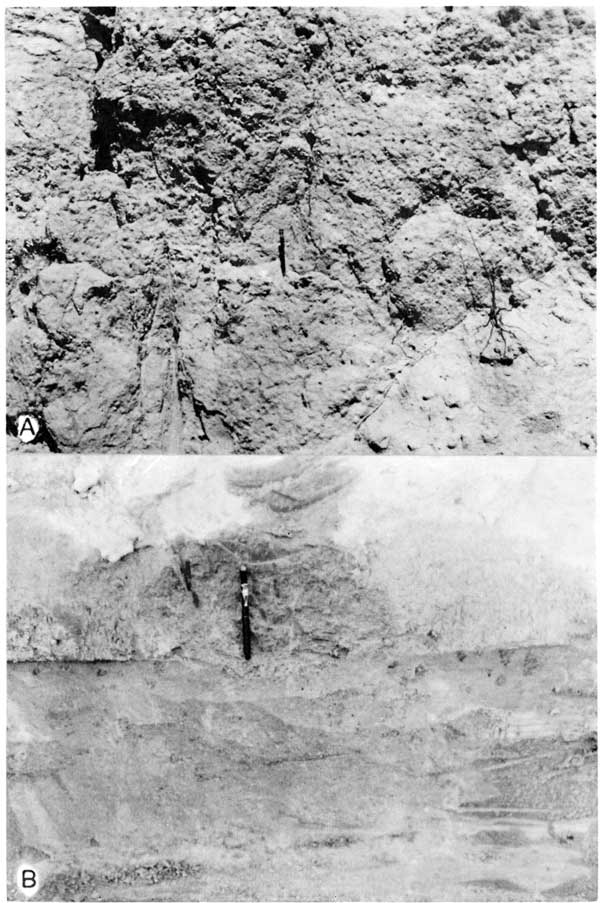
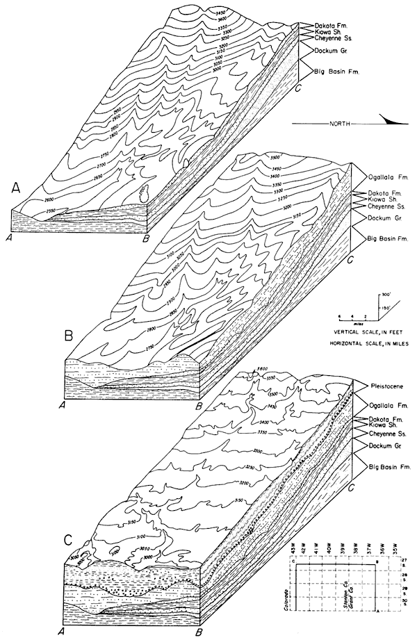
Figure 5--Block diagram showing the topography and geology of the Grant-Stanton area. A, Pre-Neogene surface dissected by Pliocene streams; B, Pre-Pleistocene surface dissected by Pleistocene streams; C, Present areal geology. (Contour interval 50 feet. Prepared by W.N. Lockwood.)
The Ogallala, as used in this report, includes all known deposits of Pliocene age identified in the subsurface in the Grant-Stanton area. Divisions of the Ogallala that have been applied elsewhere could not be applied to stratigraphic units in the area under study. Units comparable to the lower Pliocene Laverne Formation and the middle Pliocene Ash Hollow Member of the Ogallala Formation are indicated by sample logs, but additional study is necessary before correlation of these units is certain.
Distribution and thickness--The Ogallala Formation, which underlies most of the Grant-Stanton area, ranges from 0 feet in western Stanton County to approximately 200 feet in parts of eastern Grant County. A pre-Ogallala bedrock high is present in western Stanton County, and, consequently, the Ogallala may be thin or absent. Differential erosion during Pleistocene time is a further cause for the range in thickness in other parts of the area. Geologic cross sections (Pl. 3-7) illustrate the variation in thickness of the Ogallala and the, relationship of Pleistocene stream erosion upon the Ogallala surface.
Character--The Ogallala Formation consists of individual and mixed layers of stream-deposited silt, clay, sand, and gravel. Caliche and "mortar bed" (caliche-cemented sand and zones occur at several horizons throughout the formation. The presence of caliche is not by itself evidence of the presence of the Ogallala because thick caliche zones are prevalent in the Pleistocene deposits of Meade County (Hibbard and Taylor, 1960) and in other areas in southwestern Kansas.
In the Ogallala Formation, most of the sand and gravel beds lie above the basal chalky silt beds and below the upper silt and clay beds. The sand samples recovered from rotary drilling are predominantly quartz grains and particles of reworked Dakota rocks. The gravel is composed primarily of phenoclasts of reworked Dakota rocks. Ironstone and sandstone phenoclasts derived from the Dakota Formation are recognized in well cuttings. The relatively rapid rate of penetration of the Ogallala by the rotary drill, as well as the lithology of the drill-hole samples, precludes misidentification of the reworked material as bedrock. The sand and gravel of the Ogallala contain a greater amount of interbedded silt and clay lenses and are more well sorted than are similar deposits in the Pleistocene.
In most areas the lower part of the Ogallala contains yellow, chalky, silty, sand beds that were considered in the past as possibly belonging to the Dakota Formation. This chalky unit is found at the base of the Ogallala in the areas of deepest fill. "Red beds" found in association with this chalky member were considered by Smith (1940, p. 50) to be reworked material from Permian and Triassic deposits. In most instances the Ogallala can be differentiated from the underlying Cretaceous, Triassic, or Permian bedrock by its heterogeneous alluvial nature.
The upper surface of the Ogallala was modified by erosion in Pleistocene time. In north-western Kansas the so-called "Algal limestone" at the top of the Kimball Member (uppermost Ogallala) is considered as the top of the Pliocene Series (Frye and others, 1956). Because this member is missing or unrecognizable in the subsurface in the Grant-Stanton area, the Pliocene-Pleistocene contact is accordingly more difficult to differentiate. The distinctive granitic-arkosic lithofacies of the Lower Pleistocene deposits can be differentiated from the Ogallala Formation on fossil evidence over most of the area. In western Stanton County the Pliocene and Pleistocene deposits are undifferentiated.
Water supply--The Ogallala Formation is one of the principal aquifers in the Grant-Stanton area. Sand and gravel beds in the Ogallala, because of admixed silt and clay, generally do not yield as much water as comparable thicknesses of lower Pleistocene sand and gravel. In western Stanton County the Ogallala is only partly saturated or may lie above the water table.
Wells are usually perforated opposite all the water-bearing zones in areas where the Ogallala is saturated, and, hence, the yield from individual zones is not easily determined. The production of wells screened only in the Ogallala in Stanton County ranges from 450 gpm (well 28-42-6db) to 900 gpm (well 28-42-35ba) Probably no irrigation well in Grant County is screened only in the Ogallala, but yields up to 1,000 gpm in areas of thick sand and gravel may be possible. The geologic cross sections (Pl. 3-7) can be used to determine the approximate base of the Ogallala Formation and should prove helpful as a guide to well depth.
Pleistocene Series
Lower Pleistocene(?) Subseries
The Lower Pleistocene deposits, as defined in this report, include all known deposits of Nebraskan, Aftonian, Kansan, and Yarmouthian age that have been recognized in the Grant-Stanton area.
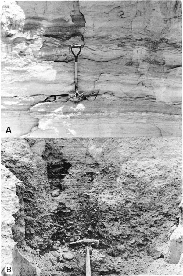
Lower Pleistocene deposits crop out as a valley fill best observed in NW NW SE sec. 28, T. 29 S., R. 43 W., in western Stanton County (Pl. 9B), and this deposit was dated as early Pleistocene (Kansan) by means of the contained molluscan fauna. In southwestern Grant County, Lower Pleistocene deposits crop out along the Cimarron River valley. The Pearlette ash bed (late Kansan) crops out in sec. 1, T. 30 S., R. 36 W., Grant County (Pl. 10A). Although the Pearlette ash bed is stratigraphic ally important, it is not continuous, and at short distances from the outcrops augering did not penetrate the ash. An outcrop of Lower Pleistocene gravel in nearby Kearny County is shown on Plate 10B. The geologic map (Pl. 1) shows the outcrop area of Lower Pleistocene deposits.
Plate 10--A, Ogallala Formation in SE sec. 12, T. 34 S., R. 43 W., Morton County; B, Lower Pleistocene stream deposits in NW NW SE sec. 28, T. 29 S., R. 43 W., Stanton County.
- Coarse sand and gravel deposits containing phenoclasts of granite, pink feldspar (orthoclase), quartz, quartzite, and rock fragments from other igneous and metamorphic rocks. Minor amounts of waterworn pebbles of caliche and chalcedony occur in the gravel and sand.
- Silt, very fine silty sand, caliche, and clay deposits that in many localities contain thin beds of coarse sand and gravel near the base. Fossiliferous blue clayey silts and silty clays are found in these fine-grained deposits in parts of the area.
[Note: In this report all references to subsurface Lower Pleistocene deposits are followed by a question mark. This query is used to indicate that, although several types of geologic evidence (similar lithology, fossil dating, and electric and radioactivity logging) were used to resolve the problem, the boundaries of the Pleistocene units are subject to revision until proven by detailed work in surrounding areas.]
Because these two major depositional units are distributed throughout much of the area, multiple working hypotheses were used to determine the relationship between them and the recognized major depositional sequences.
(1) The first hypothesis is that coarse deposits of Pliocene age were eroded by streams which later deposited fine sediments. This hypothesis was rejected because the depositional environment of the coarse deposits is more typical of conditions that are believed to have existed during Pleistocene time rather than Pliocene (Ogallala) time. The Ogallala Formation was deposited in Kansas by broad, shallow low-gradient aggrading streams which were transporting relatively fine material. Moore (1960, p. 221) in a discussion of Cenozoic history in the "Gangplank Area" of Wyoming and Colorado, with reference to the Ogallala deposits at the mountain front, reported that coarser arkosic deposits are found closer to the mountain source areas while some of the finer materials were reworked and deposited eastward on the plains. He also stated that Pleistocene erosion effected the dissection of the Tertiary mantle. It is believed that in southwestern Kansas much of the arkosic materials are reworked Ogallala sands and gravels deposited on the Plains area by Pleistocene streams.
Frye, Leonard, and Swineford (1956, p. 50-51) stated: "The earliest post-Ogallala sediments of the central Great Plains are coarser than those of the upper Ogallala, and Pleistocene materials subsequently transported eastward from the Rocky Mountains to western Kansas are considerably coarser than any of the Ogallala materials."
(2) The second hypothesis is that coarse sediment was deposited by streams in channels eroded into fine deposits of pre-Pleistocene age. The initial erosion by the Lower Pleistocene streams was into the Ogallala Formation, and the alluvial deposits of some of the small valleys in northwestern Stanton County are in a geologic setting that may lend support to this hypothesis. Subsequent erosion and deposition has obliterated much of the original Ogallala surface, leaving low hills as remnants. Fossils of Pleistocene age found at depth in fine deposits at numerous localities in Grant and Stanton counties indicate that much of the fine deposits are Pleistocene.
(3) The third hypothesis is that younger Pleistocene deposits were deposited in channels in the fine deposits of an older Pleistocene deposition cycle. Remnants of deposits of earlier Pleistocene stages are found in many stream valleys in central Kansas. This indicates that the streams have gone through alternating phases of cutting and filling which correspond to climatic changes. Frye and Leonard (1954) gave an excellent discussion of the problems encountered in mapping and interpreting outcropping terrace deposits. Because of downcutting by streams, the younger terrace deposits are topographically lower than older deposits. During the Upper Pleistocene, cycles of erosion and deposition resulted in terrace formation.
The occurrence of coarse gravel and sand deposits in close proximity to the fossiliferous, fine-grained deposits is possible under conditions of this hypothesis. Dalquest (1962) found that similar conditions existed during deposition of the fossiliferous late Pleistocene Good Creek Formation of West Texas. In Texas fossiliferous blue-clay deposits were eroded by a somewhat later channeling, followed by deposition of coarse sand and gravel.
(4) The fourth hypothesis is that coarse channel deposits are contemporaneous with finer interstream and backwater deposits, with the former representing a coarser fluviatile phase of the later. Evidence from data collected in the Grant-Stanton area supports this hypothesis. The examination of sample logs indicates that many of the gravel zones can be correlated laterally. The basal part of the sequence of fine silt and clay, which probably was deposited in the interstream and backwater areas, contains thin beds of coarse sand and gravel. Fossils collected from the blue-gray silty clay material of the finer deposits have been studied and are diagnostic of early Pleistocene age. The thicker deposits of the coarse-grained channel-phase sediments are found in the deeper parts of the valleys, while the thinner deposits are located on the flanks.
Pleistocene deposition was controlled by climatic changes which resulted in cycles of erosion, alluviation, eolation, and soil formation. These cycles have been correlated with those of the classic glaciated region of the Mississippi Valley (Frye and Leonard, 1952, p. 52; Hibbard, 1958, p. 55).
The major consequent streams during early Pleistocene time generally followed the late Pliocene water courses (Pl. 2B). After the onset of climatic and tectonic changes in the source areas, the streams became entrenched. Increased stream flow produced a concomitant increase in capacity and competency, which in turn caused a readjustment of stream gradients. After grade was established, the streams were capable of increased lateral planation which produced broad valleys. A subsequent change in climatic conditions started a period of alluviation. The streams then filled their valleys and overlapped and spread sediment over the divides. Condra, Reed, and Gordon (1950, p. 9) in a study of the Pleistocene deposits in Nebraska describe a similar condition.
From the available data, it seems that the streams were slowly aggrading and laterally migrating, and, as the channel shifted from side to side, a layer of channel sand was deposited at almost the same altitude across each of the individual valleys. However, at times the rate of sedimentation increased and the streams rapidly aggraded their channels. This may account for backwater deposits not being eroded. The fine flood-plain or backwater deposits contain fossiliferous beds. The swift-flowing, load-laden water of the channels did not as readily allow the preservation of fossils as did the quiet waters in the backwater areas.
After deposition of the alluvium, the climate changed, and the cycle of eolation and soil formation was completed. This was followed by another cycle or epicycle of erosion and alluviation.
The occurrence of fossiliferous blue clay in relation to coarse sand and gravel deposits in the Grant-Stanton area can be explained by hypotheses (3) and (4). Most likely both types of conditions occurred in the area. Additional data from nearby areas under study may lend support to these hypotheses.
Paleontologic age determination is the most important tool in the differentiation of the Pleistocene and Pliocene deposits. Fossil mollusks from the blue-gray silt and clay deposits were identified by A. B. Leonard and Tong-yun Ho, Zoology Department, University of Kansas (Table 3). The adequacy of the fossil data should be commented upon. A limited number of specimens are obtained from rotary drill cuttings. Because the type section specimens to which the subsurface specimens have been compared are greater in number and variety of species, adequate comparison is impossible. Leonard (personal communication) is reasonably sure of the Pliocene, Pleistocene, and Early-Late Pleistocene faunal age boundaries. His recognition of Pleistocene stages is based upon the number and percentage of species present. The fossil occurrences (Table 3) are assigned to specific Pleistocene stages but because of the inconsistencies of the fossil record, the data are used only to indicate the Early-Late Pleistocene boundary.
| Well number and depth interval | |||||||||||||||||||||||
|---|---|---|---|---|---|---|---|---|---|---|---|---|---|---|---|---|---|---|---|---|---|---|---|
| 27-35-4bbb, 10'-20' |
27-37-34ccc, 110'-120' |
27-39-18bbb, 70'-110' |
28-36-17bbb, 230'-240' |
28-37-5bc, 200'-210' |
28-37-5bc, 200'-220' |
28-37-21daa1, 110'-120' |
28-37-21daa1, 120'-170' |
28-37-26ac, outcrop |
28-37-26bcc, 40'-50' |
28-37-26bcc, 160'-180' |
28-37-26dcc, 0'-20' |
28-37-26dcc, 20'-30' |
28-37-26dcc, 130'-140' |
28-37-26dcc, 140'-150' |
28-37-26dcc, 150'-160' |
28-39-13cbb, 220'-260' |
29-36-2ccb, 180'-200' |
29-36-7dcc, 10'-20' |
29-36-21cdc, 30'-40' |
29-43-28abb, outcrop |
30-36-24ccc, 20'-30' |
30-37-2cd2, 200'-210' |
|
| Age* | |||||||||||||||||||||||
| Species | 4? | 2 | 2 | 1 | 5 | 1? | 1? | 1 | 3 | 3 | 1 | 2?3? | 2 | 2 | 1 | 1? | 1? | 5 | 4 | 2 | 2 | 2? | 1 |
| Calipyroula tumida Leonard | ? | ||||||||||||||||||||||
| Deroceras aenigma Leonard | X | X | |||||||||||||||||||||
| Ferrissia sp. | X | ||||||||||||||||||||||
| Gastrocopta armifera (Say) | X | ||||||||||||||||||||||
| Gastrocopta cristata Pilsbry & Vanatta | X | X | |||||||||||||||||||||
| Gasrocopta paracristata Franzen & Leonard | X | ||||||||||||||||||||||
| Gastrocopta procera (Gould) | X | X | X | X | |||||||||||||||||||
| Gastrocopta tappaniana (Adams) | X | ||||||||||||||||||||||
| Gyraulus crista (Linné) | X | ||||||||||||||||||||||
| Gyraulus labiatus Leonard | X | X | |||||||||||||||||||||
| Gyraulus similaris Baker | X | X | X | X | |||||||||||||||||||
| Gyraulus sp. | X | ||||||||||||||||||||||
| Hawaiia minscula (Binney) | X | X | X | X | X | X | |||||||||||||||||
| Helicodiscus eigenmanni Pilsbry | X | ||||||||||||||||||||||
| Helicodiscus parallelus (Say) | X | ||||||||||||||||||||||
| Helicodiscus singleyanus Pilsbry | X | X | |||||||||||||||||||||
| Helisoma antrosa (Conrad) | X | X | |||||||||||||||||||||
| Helisoma sp. | X | ||||||||||||||||||||||
| Helisoma trivolvis (Say) | ? | ||||||||||||||||||||||
| Lymnaea bulimoides Lea | X | ||||||||||||||||||||||
| Lymnaea caperata (Say) | X | X | |||||||||||||||||||||
| Lymnaea diminuta Leonard | X | X | X | ||||||||||||||||||||
| Lymnaea macella Leonard | X | ||||||||||||||||||||||
| Lymnaea palustris Muller | X | X | |||||||||||||||||||||
| Lymnaea parexilis Leonard | ? | ? | ? | ? | |||||||||||||||||||
| Lymnaea parva Lea | X | X | |||||||||||||||||||||
| Lymnaea reflexa Say | X | X | X | X | X | ||||||||||||||||||
| Lymnaea turritella Leonard | X | X | |||||||||||||||||||||
| Menetus kansasensis Baker | X | X | X | X | X | ||||||||||||||||||
| Menetus pearlettei Leonard | X | ? | |||||||||||||||||||||
| Physa anatina Lea | X | X | X | X | |||||||||||||||||||
| Physa hawnii Lea | X | ||||||||||||||||||||||
| Physa sp. | X | X | X | X | X | X | X | X | X | X | X | X | |||||||||||
| Pisidium compressum Prime | X | ||||||||||||||||||||||
| Pisidium sp. | X | X | X | X | |||||||||||||||||||
| Promenetus blancoensis Leonard | X | X | |||||||||||||||||||||
| Promenetus umbilicatellus (Cockerell) | X | ||||||||||||||||||||||
| Pupilla muscorum (Linne) | X | X | X | X | X | X | |||||||||||||||||
| Pupoides albilabris (Adams) | X | X | X | X | |||||||||||||||||||
| Retinella electrina (Gould) | X | ||||||||||||||||||||||
| Strobilops sparsicostata Baker | X | ||||||||||||||||||||||
| Succinea avara Say | X | ||||||||||||||||||||||
| Succinea grosvenori Lea | X | X | X | X | X | X | X | ||||||||||||||||
| Succinea sp. | X | X | X | X | X | ||||||||||||||||||
| Vallonia gracilicosta Reinhardt | X | X | X | X | X | X | X | ||||||||||||||||
| Valvata tricarinata (Say) | X | ||||||||||||||||||||||
| Vertigo milium (Gould) | X | X | X | ||||||||||||||||||||
| Vertigo ovata Say | X | X | X | ||||||||||||||||||||
| Total number species | 4 | 2 | 10 | 2 | 1 | 3 | 1 | 11 | 9 | 1 | 12 | 4 | 5 | 7 | 9 | 1 | 6 | 2 | 4 | 15 | 11 | 4 | 4 |
| * 1, Nebraskan; 2, Kansan; 3, Illinoisan; 4, Wisconsinan; 5, Pleistocene undifferentiated. | |||||||||||||||||||||||
The micro-vertebrates collected from the fossil zones were identified by C. W. Hibbard, Curator of Vertebrates, Museum of Paleontology, University of Michigan. Much of the micro-vertebrate material was fragmentary and not of stratigraphic use as guide fossils. The following, resume of the stratigraphically important micro-vertebrate fauna was given by Dr. Hibbard:
27-39-18bbb, Stanton County, 100-110 feet; Citellus sp., lower molar M 1 or M 2; probable age post-Rexroad (late Pliocene) and pre-Butler Spring and Berends local faunas (Illinoisan).
28-38-34bbb, Grant County, 40-44 feet; part of microtine tooth; this type of tooth is known from the base of the Pearlette Ash Bed to Recent (primary Wisconsinan deposits).
The fresh-water ostracodes (Table 4) found in the fossiliferous zones were examined by E. D. Gutentag. These ostracodes are similar to those in the Pleistocene fauna from Meade County described by Gutentag and Benson (1962). The ecology and fossil distribution of the fresh-water ostracode faunas are not well enough known to date glacial and interglacial stages of the Pleistocene, but Candona nyensis Gutentag and Benson, so far as it is known, is restricted to deposits of Pleistocene age in southwestern Kansas.
Table 4--Occurrence of Pleistocene fresh-water ostracodes in the Grant-Stanton area. (Identification by E. D. Gutentag.)
| Well number | Depth interval, in feet |
Species |
|---|---|---|
| 27-36-1bba | 225-311 | Candona nyensis Gutentag and Benson |
| Cyprideis littoralis Brady | ||
| Cyclocypris of C. ovum Miller | ||
| 27-38-25aaa | 150-160 | Candona nyensis Gutentag and Benson |
| Candona sp. | ||
| 27-39-18bbb | 70-100 | Candona nyensis Gutentag and Benson |
| 29-35-19dc | 320-330 | Candona nyensis Gutentag and Benson |
| Cyprideis littoralis Brady | ||
| Cyclocypris of C. ovum Miller | ||
| Candona sp. | ||
| 29-35-28aa | 205-215 | Candona nyensis Gutentag and Benson |
| Candona of C. crogmaniana Turner | ||
| Candona sp. | ||
| Cyclocypris of C. ovum Miller | ||
| Limnocythere sp. | ||
| 29-35-28aa | 230-240 | Candona nyensis Gutentag and Benson |
| Candona of C. crogmaniana Turner | ||
| Candona sp. | ||
| Cyclocypris of C. ovum Miller | ||
| 29-36-21cdc | 130-140 | Candona nyensis Gutentag and Benson |
| Candona sp. |
Distribution and thickness--Deposits of early Pleistocene age underlie most of the Grant-Stanton area. The thickness ranges from 0 feet in southwestern Stanton County to 275 feet in southeastern Grant County. The average thickness for the eastern two-thirds of the area is approximately 170 feet.
The configuration and drainage pattern of Lower Pleistocene streams on the Ogallala surface are shown on Plate 2B. Geologic cross sections (Pl. 3-7) show the thickness of the Pleistocene deposits. Upper Pleistocene deposits have not been differentiated from the Lower Pleistocene deposits on the cross sections because when saturated they compose a hydrologic unit. The Pliocene Ogallala Formation is not differentiated from the Pleistocene deposits in western Stanton County.
Character--Lower Pleistocene channel deposits consist of thick sequences of gravel and coarse sand. Thin beds of coarse deposits underlie the fine-grained backwater deposits throughout most of the area. The phenoclasts in these beds consists of granite, pink feldspar (orthoclase), quartz, quartzite, and fragments of igneous and metamorphic rocks. Minor amounts of water-worn pebbles of caliche and chalcedony are found interspersed in the gravel and sand.
The gray, silty, fosiliferous facies occur in backwater deposits. These beds are generally continuous, but fossils are found in some samples only. The Pearlette ash bed, which is a lower Pleistocene stratigraphic marker bed, was reported in 1939 from test hole 28-39-2ccc at a depth of 80 to 94 feet, but it has not been found in other test holes.
In the upper part of the Lower Pleistocene deposits, beds of reddish-brown and tan silt, fine sand, and clay are found overlying the lower valley fill and backwater deposits. Massive beds and thin stringers of caliche are common in these deposits.
Water supply--Most of the water pumped in the area is probably from Lower Pleistocene aquifers. Most irrigation wells screened in both Pleistocene and Pliocene deposits receive the larger part of their yields from the Lower Pleistocene deposits. Wells screened only in Lower Pleistocene deposits are reported to yield as much as 2,000 gpm. However, yields from 3,000 to 5,000 gpm are possible.
Upper Pleistocene Subseries
The Upper Pleistocene deposits, as defined in this report, include deposits of Illinoisan, Sangamonian, Wisconsinan, and Recent age that have been recognized in the Grant-Stanton area. Upper Pleistocene deposits mantle most of the present surface (Fig. 5C). The Upper-Lower Pleistocene contact indicated on some well logs and the geologic cross sections is not differentiated throughout the area. Until further evidence is available from areas adjacent to the Grant-Stanton area, the assignment of beds to the Upper Pleistocene Subseries is subject to revision and is indicated by a query (?) on the well logs.
Deposition of Upper Pleistocene sediments was characterized by cycles and epicycles of erosion, alluviation, eolation, and soil formation comparable to those of the Lower Pleistocene. Cycles of erosion and subsequent alluviation are indicated in well 27-35-4bbb, where the base of the 49-foot coarse gravel bed at 142 feet lies upon the finer deposits of early Pleistocene age. The coarse gravel represents an alluvial cycle, which aggraded a valley that was previously cut into the Lower Pleistocene deposits. Mollusks recovered from this test hole (Table 3) at a depth interval of 10 to 20 feet were assigned an early Pleistocene age (probably Wisconsinan). This fossil-bearing interval may represent a loess deposit between the finer fossil-bearing sandy silt and the coarse gravel. Fossils of Illinoisan Age (late Pleistocene) (Table 3) were recovered from a silty sand deposit in a pit east of Ulysses in Grant County in the SW NE sec. 26, T. 28 S., R. 37 W., at an altitude of approximately 2,990 feet. At a nearby test hole in the SW SW NW sec. 26, at an altitude of 3,038 feet, Illinoisan fossils were found at a depth interval of 40-50 feet. Fossils of Nebraskan Age where identified at a depth of 160-180 feet in this test hole (Table 3). The lithologic break between the Upper and Lower Pleistocene is at 50 feet. Therefore, the interval between 50 and 180 feet can be placed with some degree of certainty as Lower Pleistocene.
Distribution and thickness--Upper Pleistocene deposits that crop out in the Grant-Stanton area consist of loess, dune sand, and alluvium. These deposits extend over a wide area, as shown by the geologic map (Pl. 1). The Upper Pleistocene deposits, which have been tentatively differentiated in the subsurface, range in thickness from 10 to 270 feet. The average thickness is approximately 110 feet.
Character--The gravel and coarse sand deposits are representative of channel fills and are coarser than their equivalents in the Lower Pleistocene deposits. The phenoclasts consist of quartz, quartzite, granite, basalt, fine-grained acid igneous rocks, and metamorphic rocks. Sandstone locally derived from the Dakota Formation may be common. The finer materials consist of clay, silt, sandy silt, and fine sand. Caliche horizons are developed in some of these deposits.
Water supply--Upper Pleistocene deposits lie above the water table in most of the Grant-Stanton area. Along the major streams, the deposits are saturated and are reported to yield as much as 750 gpm to wells. Saturated deposits of late Pleistocene age, together with the Lower Pleistocene deposits, are considered as a hydrologic unit because they exhibit similar hydrologic characteristics. Dune sand in the Grant-Stanton area lies above the water table and yields no water to wells, but it may form a catchment area for precipitation and may facilitate recharge to the Pleistocene aquifers.
Prev Page--Geology || Next Page--Hydrology
Kansas Geological Survey, Geology
Placed on web July 17, 2007; originally published December 1964.
Comments to webadmin@kgs.ku.edu
The URL for this page is http://www.kgs.ku.edu/General/Geology/Stanton/05_form.html