![]()
Prev Page--Introduction || Next Page--Geology
Geography
Topography and Drainage
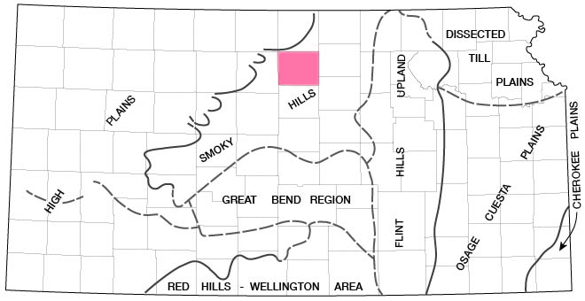
Mitchell County lies within the Plains Border section of the Great Plains physiographic province as defined by Fenneman (1931). In Adams' physiographic divisions of Kansas (1903), Mitchell County lies within the Smoky Hills Upland division. Later Schoewe (1949) placed the area within the Dissected High Plains physiographic division of Kansas. More recently Frye and Schoewe (1953) have proposed that the area be placed within the Smoky Hills physiographic division of Kansas (Fig. 3).
Figure 3--Physiographic regions of Kansas, showing areas of topographic homogeneity (after Frye and Schoewe, 1953).
Surface drainage in Mitchell County is controlled chiefly by Solomon River and its tributaries. Salt Creek is the largest stream in the southern part of the county, and flows eastward to a confluence with Solomon River in Ottawa County. The southwestern corner of Mitchell County is drained by tributaries of Saline River, which flows eastward across Lincoln County. The valley of Solomon River is asymmetrical, the south walls being markedly steeper than the north walls. Asymmetrical valleys are characteristic of eastward- (and westward-) flowing streams in Kansas. Such valleys are believed to result from a combination of climatic factors that cause more rapid weathering and erosion of southward-facing slopes, which in turn results in deposition of more material on the north slope, thus forcing the river southward (Bass, 1929, p. 17-23).
Topographically Mitchell County can be divided into three areas: the alluvial valleys, the dissected upland, and the Blue Hills. The alluvial valleys are those of Solomon River and its major tributaries. The Solomon River valley consists of a narrow flood plain and broad terraces designated the Kirwin Terrace by Leonard (1952). The surface of the Kirwin Terrace is consistent with the terrace surfaces in the major tributary valleys. North and South Forks of Solomon River join about 2 miles south of Cawker City to form the main stream. Salt Creek drains much of the southern part of the county. The valley of Salt Creek is broad and flat, and is entrenched by the narrow channel of the creek. Most of Mitchell County is a rolling upland plain moderately dissected by the tributaries of Solomon River in the central and northern parts of the county and by those of Salt Creek in the southern part. The upland consists of rounded to moderately steep sided hills of Cretaceous bedrock covered by a relatively thin layer of loess. The walls of the valleys through which the smaller streams flow are gently sloping for the most part. The Blue Hills in the southwestern part of Mitchell County stand almost 300 feet above the general upland level. The hills are buttes and small mesas; the steep slopes are developed on the Blue Hill Shale member of the Carlile Shale, which is capped by the Fort Hays Limestone member of the Niobrara Formation. Soil on the butte tops is very thin and stony.
The average altitude of Mitchell County is about 1,600 feet. The lowest altitude, about 1,300 feet, is along Solomon River at the east boundary of the county. The altitude of the Blue Hills in the southwestern part of the county is nearly 1,900 feet. In the western part of Mitchell County, Solomon River flows about 150 feet below the general summit level of the upland. In the eastern part, Solomon River flows about 250 feet below the upland. From the Kirwin Terrace level the relief of the upland ranges from about 100 feet in the western part of the county to slightly more than 200 feet in the eastern part. Scattered small remnants of Pleistocene alluvial deposits form high terraces along the valley walls.
Climate
The climate of Mitchell County is subhumid (U. S. Department of Agriculture, 1941) and is characterized by relatively cold winters and warm summers. Annual precipitation (Fig. 5) exceeds mean annual water loss (precipitation minus runoff, Fig. 11) by only a small margin. Precipitation normally is concentrated in the late spring and early summer when it is most effective for the growing of crops. The principal source of moisture is tropical air from the Gulf of Mexico. Winter weather is variable as a result of the procession of cyclones and anticyclones and their assorted tropical and polar air masses that cross the region.
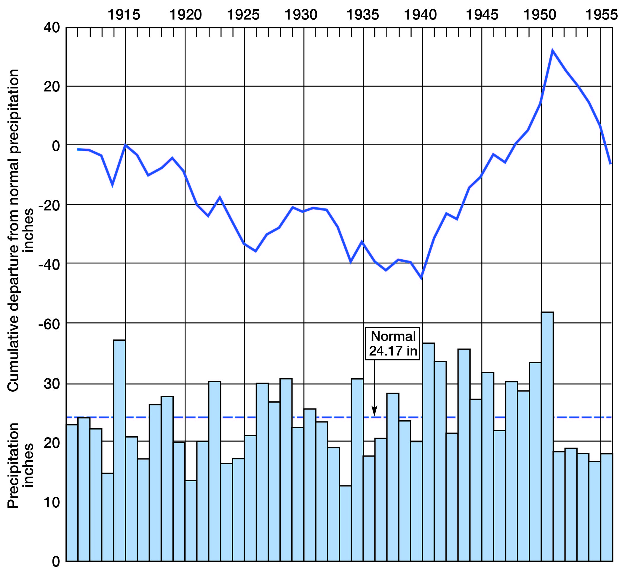
According to records of the U. S. Weather Bureau and to Flora (1948), the mean annual temperature of Mitchell County is about 54° F. The longest growing season and the shortest growing season on record are 194 days and 128 days, respectively. Figure 4 shows graphically the normal monthly precipitation at Beloit. The normal annual precipitation in Mitchell County is 24.17 inches, about 75 percent of which falls during the 6 months of the growing season. Records show that the precipitation at Beloit has ranged from a minimum of 12.46 inches during 1934 to a maximum of 41.95 inches during 1951. The annual precipitation and cumulative departure from normal precipitation are shown in Figure 5.
Figure 4--Normal monthly precipitation at Beloit for the period 1898-1942.
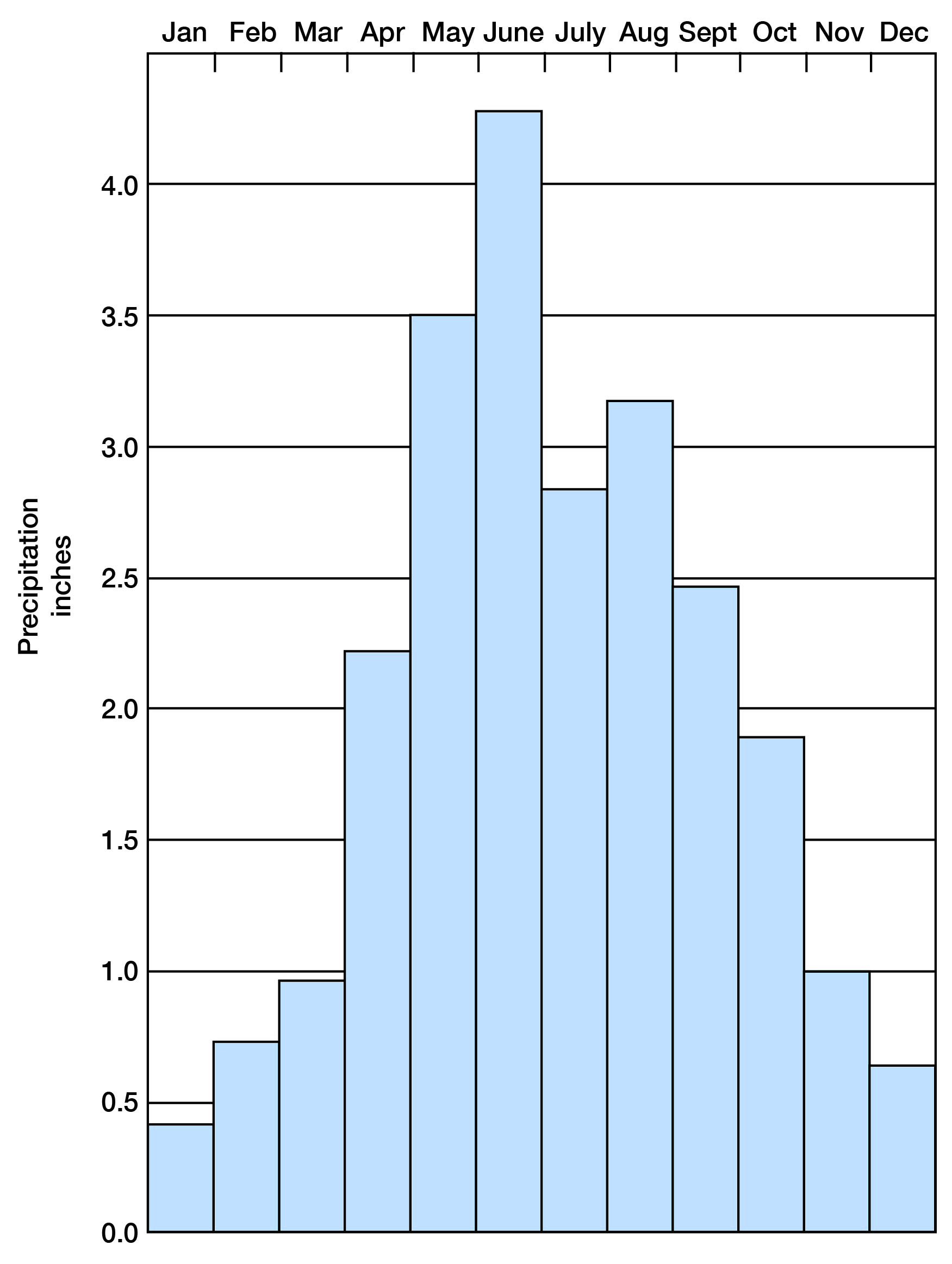
Figure 5--Annual precipitation and cumulative departure from normal precipitation at Beloit.
Population
According to the 1950 census, Mitchell County had a population of 10,320, of which 6,235 were rural and 4,085 were urban. The population density in the more thickly settled Solomon Valley area is considerably greater than the average for the county. [Note: Mitchell County population was listed as 6,932 in 2000 U.S. census, ranking 56th, with a density of 9.9 (32.9 for the state) (KU Institute for Policy & Social Research).] The 1950 population of Beloit, the county seat and largest city, was 4,085 [4,019 in 2000]. Cawker City [521 in 2000], Glen Elder [439 in 2000], and Simpson [114 in 2000], three other communities within Solomon Valley, had populations of 547, 305, and 298, respectively. Tipton [243 in 2000] and Hunter [77 in 2000], in southwestern Mitchell County, had populations of 246 and 236, respectively; Scottsville, in the northwestern corner of the county, had a population of 108 [21 in 2000].
Transportation
Three railroads serve the county. A line of the Missouri Pacific Railroad Co. extends east-west along the north side of the Solomon Valley and northeastward from Beloit through Scottsville. A branch line of the Union Pacific Railway Co. extends southeastward from Beloit. A line of the Atchison, Topeka & Santa Fe Railway Co. crosses the southwest corner of the county through Tipton and Hunter. U. S. Highway 24 extends east-west along the Solomon Valley, and Kansas Highway 9 from the east joins U. S. Highway 24 near Beloit. Kansas Highway 14 runs north-south through Beloit, and Kansas Highway 128 extends north from a point near Glen Elder. Kansas Highway 181 crosses the southwest corner of the county through Tipton and Hunter. The rest of the county is served by improved county and township roads.
Agriculture
Agriculture is the chief industry in Mitchell County, wheat being the principal crop. Other major crops are sorghum, oats, barley, and alfalfa. Cattle and sheep are the predominant livestock. The distribution of cultivated and grazing land is influenced by topography and stratigraphy. Nearly all the cultivated land lies in the alluvial valleys or on the loess-mantled uplands. The grazing land is generally the rolling upland having a thin soil cover underlain by limestone or shale.
Prev Page--Introduction || Next Page--Geology
Kansas Geological Survey, Geology
Placed on web June 16, 2009; originally published April 1959.
Comments to webadmin@kgs.ku.edu
The URL for this page is http://www.kgs.ku.edu/General/Geology/Mitchell/03_geog.html