![]()
Prev Page--Contents || Next Page--Geography
Introduction
Purpose of Investigation
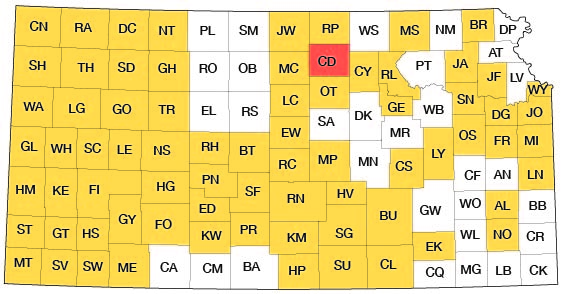
A program of investigation of the ground-water resources of Kansas was begun in 1937 by the United States Geological Survey and the State Geological Survey of Kansas with the cooperation of the Division of Sanitation of the State Board of Health and the Division of Water Resources of the State Board of Agriculture. The investigation of that part of Cloud County that lies within the Republican Valley was integrated with the program of the Interior Department for development of the Missouri River basin. The investigation of Cloud County began in August 1953 and is similar to other investigations that have been completed or are being made in other counties in Kansas. The present status of investigations is shown in Figure 1.
Figure 1--Index map of Kansas showing area described in this report and areas covered by other online geologic reports, as of June 2009. For additional information, please visit the KGS Geologic Maps of Kansas Page.
Ground water is one of the principal natural resources of Cloud County. Nearly all public, domestic, and industrial water supplies and many stock water supplies are obtained from wells. The use of ground water for irrigation is increasing and probably will continue to increase at an accelerated rate. At the present rate of withdrawal the danger of seriously depleting the ground-water supply or of impairing the quality of the water by encroachment of saline waters is slight, but an adequate understanding of the quality and quantity of the available ground-water supply is needed to aid in future development.
Location and Extent of Area
Cloud County is in north-central Kansas, in the second tier of counties from the north border of the state and just east of the center of the state. The county contains 20 townships from T. 5 to T. 8 S., and from R. 1 to R. 5 W. and includes an area of 711 square miles. The location of Cloud County is shown in Figure 1.
Previous Investigations
The principal studies of the geology and ground-water resources of north-central Kansas that have a bearing on Cloud County are mentioned below. Specific references are cited at appropriate places in the text by author and date, and are given under References at the end of the report.
The geology of the Upper Cretaceous in Kansas was described by Logan in 1897. Darton (1905) made reference to wells in north-central Kansas in a preliminary report of the geology and ground-water resources of the central Great Plains. Haworth (1913) prepared a report on well waters in Kansas in which he discussed the availability of ground water in the Republican River valley. A report by Wing (1930) of the geology of Cloud and Republic Counties was the first detailed report on this area. Moore and others (1940) prepared a generalized report on the ground-water resources of Kansas. A detailed report on the outcrop area of the Dakota Formation was made by Plummer and Romary (1942). Fishel (1948) prepared a report on the groundwater resources of Republic County and northern Cloud County, which included data from about the northern fourth of Cloud County. A report describing the geology and engineering construction materials in Cloud County was prepared by Buck and others (1951). Schoewe (1952) prepared a report on the coal resources of the Dakota Formation in which the occurrence of coal in Cloud County is discussed.
Methods of Investigation
In all, 2 months in the fall of 1953, 3 months in the summer of 1954, and 1 month in the fall of 1955 was spent in Cloud County collecting the data upon which this report is based. Geology was mapped in the field on aerial photographs from field observations and stereoscopic study of aerial photographs. Data were transferred from the photographs to a base map by means of a focalmatic projector.
Data on the total depth, depth to water, yield, and character of the water-bearing material of 170 wells (Table 16) were collected. Test holes were bored with a power auger at 150 locations; 100 were bored in alluvial or terrace material to obtain depth-to-water measurements included in Table 16 and 50 were bored to obtain geologic information. Forty-four test holes were drilled with a hydraulic-rotary drilling machine owned by the State Geological Survey of Kansas and operated by E. L. Reavis and William Gellinger to obtain geologic information. Logs of test holes were prepared in the field and modified later after microscopic study of the drill cuttings in the laboratory. Level parties headed by Woodrow W. Wilson and E. L. Reavis determined the altitudes of wells and test holes by means of a plane table and alidade. Fifty-seven samples of water from wells and test holes were collected and were chemically analyzed by Howard Stoltenberg, chemist in the Water and Sewage Laboratory of the Kansas State Board of Health (Table 3).
Well-numbering System
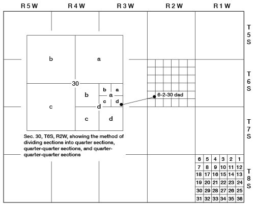
In this report the well, auger-hole, and test-hole numbers accord with the General Land Office system of land classification. The component parts of a well number are the township number, range number, section number, and three lowercase letters indicating respectively the quarter section, quarter-quarter section, and the quarter-quarter-quarter section. The lowercase letters are assigned in a counterclockwise direction beginning in the northeast quarter of each section or subdivision. For example, well 6-2-30dad (Fig. 2) is in the SE NE SE sec. 30, T. 6 S., R. 2 W. If there are two or more wells within the same quarter-quarter-quarter section they are numbered serially according to the order in which they are inventoried.
Figure 2--Map of Cloud County illustrating well-numbering system used in this report.
Acknowledgments
Appreciation is expressed to the many residents of Cloud County who supplied information and aided in the collection of field data. Special acknowledgment is given the officials of the many cities who provided information about their water supplies. Acknowledgment is made also of the information supplied by George Cox, J. G. Lassey, and Carl Thoman, well drillers in Cloud County. Franklin Day, W. T. Wright, and James Doorman cooperated in permitting use of their irrigation wells for aquifer tests.
The manuscript of this report was reviewed by several members of the Federal Geological Survey and the State Geological Survey; by Robert Smrha, Chief Engineer, and George S. Knapp, Engineer, of the Division of Water Resources, Kansas State Board of Agriculture; and by Dwight Metzler, Director and Chief Engineer, and Willard O. Hilton, Geologist, of the Division of Sanitation, Kansas State Board of Health.
Prev Page--Contents || Next Page--Geography
Kansas Geological Survey, Geology
Placed on web June 29, 2009; originally published May 1959.
Comments to webadmin@kgs.ku.edu
The URL for this page is http://www.kgs.ku.edu/General/Geology/Cloud/02_intro.html