Kansas Geological Survey, Open-File Rept. 93-1
Annual Report, FY92--Page 14 of 20
In the first series of simulations only a maximum value of the vertical hydraulic conductivity of the Upper Cretaceous aquitard could be determined from the RMS error. The asymmetry of the error curve suggests a maximum vertical hydraulic conductivity of 3 x 10⁻⁷ ft/day (9 x 10⁻⁸ m/day). The RMS error increases from 79 ft (24 m) to 164 ft ( 80 m) as the vertical hydraulic conductivity increases to 3 x 10⁻⁵ ft/day (9 x 10⁻⁶ m/day) Decreases in the vertical hydraulic conductivity below 3 x 10⁻⁷ ft/day (9 x 10⁻⁸ m/day) have little effect on the RMS error.
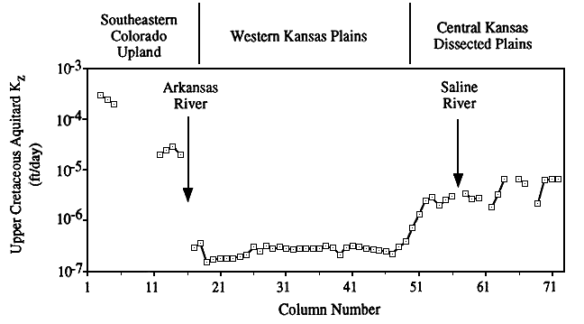
In the second series the vertical hydraulic conductivity of the aquitard was assumed to vary from cell to cell in the model. The resulting RMS error decreased by 42% to 46 ft (14 m). This indicates that a nonuniform vertical hydraulic conductivity is more appropriate than a uniform value for this model layer. The vertical hydraulic conductivity ranges from 3.0 x 10⁻⁴ ft/day to 1.8 x 10⁻⁷ ft/day (9 x 10⁻⁵ to 5.5 x 10⁻⁸ m/day) across the model (Figure 36). In the individual sections of the model the vertical hydraulic conductivity ranges from 3.0 x 10⁻⁴ to 2.0 x 10⁻⁵ ft/day (9 x 10⁻⁵ to 6 x 10⁻⁶ m/day) in the southeastern Colorado upland, 3.8 x 10⁻⁷ to 1.7 x 10⁻⁷ ft/day (1.2 x 10⁻⁷ to 5.2 x 10⁻⁵ m/day) in the western Kansas plains, and 6.3 x 10⁻⁶ ft/day to 7.1 x 10⁻⁷ ft/day (1.9 x 10⁻⁶ to 2.2 x 10⁻⁷ m/day) in the central Kansas dissected plains.
Figure 36--Variation in vertical hydraulic conductivity of the Upper Cretaceous aquitard from the partially calibrated steady-state model. Vertical hydraulic conductivity is lowest in the western Kansas plains section of the model and highest in the southeastern Colorado upland section.
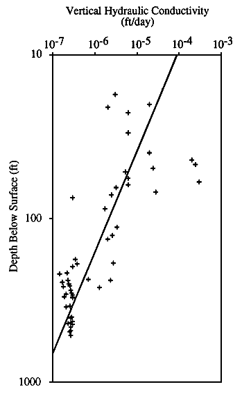
The results from both simulations are consistent with the results of Belitz (1985) and Belitz and Bredehoeft (1988). They found that only a maximum vertical hydraulic conductivity could be determined from model sensitivity if the vertical hydraulic conductivity was treated as a uniform property of the layer. Their maximum value is one order of magnitude less than the maximum value reported from the first simulation series. They also reported improvement in the error of their multilayer model of the Denver basin when the vertical hydraulic conductivity was treated as a depth-dependent variable ranging over three orders of magnitude from 100 ft to 10,000 ft (30-3,000 m) of depth. Figure 37 is a plot of the partially calibrated cell-by-cell vertical hydraulic conductivity versus the cell-by-cell node depth for the Upper Cretaceous aquitard. The log-log plot and the best-fitting line through the data show that vertical hydraulic conductivity generally decreases with depth. Vertical hydraulic conductivity decreases over three orders of magnitude for a depth range from 17.5 ft to 522.5 ft (5.3-159 m). The r2 value indicates that approximately 61% of the variation in the data is explained by the log-log relationship between the two variables and demonstrates that vertical hydraulic conductivity is a depth-dependent variable in this aquitard.
Figure 37--Vertical hydraulic conductivity of the Upper Cretaceous aquitard versus depth below land surface showing the best-fitting line by least-squares regression. The value of the correlation coefficient r is 0.78.
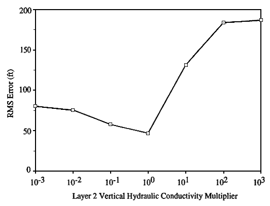
In Figure 38 the RMS error is sensitive to the increase in hydraulic conductivity above the calibrated cell-by-cell set of values. The sensitivity of heads in the upper Dakota aquifer to the increase in vertical hydraulic conductivity of the aquitard results because more and more recharge can enter the model. This causes heads in the upper Dakota aquifer to increase as the hydraulic connection between the aquifer and the overlying water table improves. The flux increase is most pronounced in the western Kansas plains, where the volumetric flow rate increases by more than two orders of magnitude. However, the recharge rate is still negligible with comparison to the other sections of the model.
Figure 38--Model sensitivity to the nonuniform vertical hydraulic conductivity of the Upper Cretaceous aquitard in the partially calibrated model, expressed as RMS error.
In the central Kansas dissected plains the volumetric flow rate increases by one order of magnitude, and all the streams receive discharge from the model. In the southeastern Colorado upland there is a small increase in the rate of recharge and discharge. With the increase in vertical hydraulic conductivity the total volumetric flow rate through the model increases to 193.5 cubic ft/day (5.5 cubic m/day), an increase of more than 1,000% over the total flow rate in the partially calibrated model. The heads in the upper Dakota are more than 200 ft (61 m) higher than those in the partially calibrated model between the two rivers in the western Kansas plains. The RMS error is not as sensitive to decreases in vertical hydraulic conductivity below the partially calibrated cell-by-cell set of values.
As the aquitard becomes less permeable, recharge is progressively shut off to the model through its upper boundary. As a result, recharge to the upper Dakota is reduced and the heads in the aquifer decrease relative to the overlying water table. The decrease in vertical hydraulic conductivity causes a two to three order of magnitude decrease in recharge across the upper model boundary in the western Kansas plains. Recharge and discharge rates are also lower in the southeastern Colorado upland and the central Kansas dissected plains. The Saline River and some of its tributaries continue to receive discharge from the regional flow system but at lower rates. The other tributaries continue to supply recharge to the flow system but at higher rates.
Discharge to the Arkansas River is unaffected by the vertical hydraulic conductivity decrease. The total volumetric flow rate decreases by 37% of the partially calibrated total volumetric flow rate to 10.4 cubic ft/day (0.3 cubic m/day) in this simulation. The decrease in vertical hydraulic conductivity causes the head difference between the water table and the upper Dakota aquifer to increase by approximately 50 ft (15 m) because of the reduction in recharge. This small increase in the head differential suggests that recharge to the upper Dakota aquifer from the Upper Cretaceous aquitard in the western Kansas plains is already small in the partially calibrated model relative to the underflow in the aquifer from upgradient parts of the model.