


Kansas Geological Survey, Open-File Rept. 93-1
Annual Report, FY92--Page 11 of 20
Effect of River Valleys..., continued
Ground-Water Flow Patterns in the Upper Part of the Regional Flow
System
Figure 29 is a vertical profile of freshwater equivalent hydraulic heads in the upper
part of the regional flow system. Ground-water flow directions are assumed to be from
higher to lower head and perpendicular to the equipotentials. The dominant flow direction
in the upper aquifers above the Permian-Pennsylvanian aquitard is parallel to the regional
topography from elevated recharge areas in southeastern Colorado to discharge areas in
central Kansas. In the deeper part of the system in southeastern Colorado, the flow
direction is downward and away from the upthrown Precambrian block on the west side of
the Freezeout Creek fault zone. Farther east in the Western Kansas basin and the Central
Kansas uplift areas, the vertical flow direction is downward across all the aquitards toward
the deeper part of the regional flow system. In these areas the nearly horizontal orientation
of the equipotentials in the Permian-Pennsylvanian and evaporite aquitards indicates that the
Dakota aquifer and other shallow aquifers are hydraulically isolated from the deeper
aquifers below the evaporite aquitards.
Figure 29--Predevelopment distribution of head (ft above mean
sea level) in the vertical profile. The boundary between the intermediate-scale flow
system and the regional flow system is shown by the bold line.
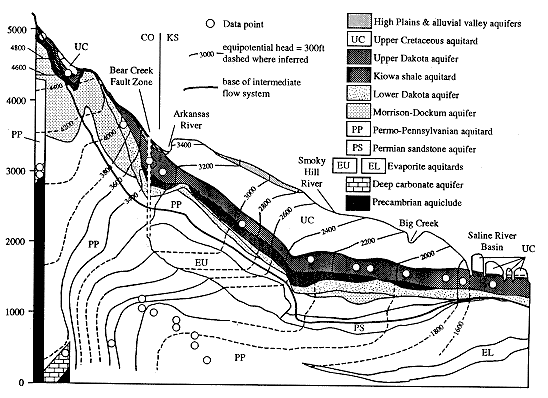
The boundary separating the upper from the lower part of the flow system is a flow
line and is shown in Figure 29. Ground-water flow above this flow line is dominated by
the lateral movement of ground water in aquifers from recharge areas in southeastern
Colorado to discharge areas in central Kansas and points eastward. Below the boundary
ground-water flow is across the thick Permian-Pennsylvanian and the evaporite aquitards to
the deeper aquifers in southeastern Colorado and western and central Kansas. This
conceptualization of the flow system is consistent with Belitz (1985), Belitz and Bredehoeft
(1988), and Jorgensen et al. (1993). The upper portion of the flow system is interpreted as
part of a large intermediate-scale system, whereas the lower part is interpreted as a portion
of the regional system.
Previous page--Results and Interpretation ||
Next page--Simulation of Flow System
Start of this report ||
Table of Contents
Kansas Geological Survey, Dakota Project
Updated Jan. 1997
Comments to webadmin@kgs.ku.edu
URL=http://www.kgs.ku.edu/Dakota/vol3/fy92/rep11.htm