Kansas Geological Survey, Open-File Rept. 91-1
Annual Report, FY91--Page 4 of 8
This section describes methods used to extract aquifer properties from conventional wireline logs run in the Dakota aquifer. These are reported together with results that are specific to the Dakota, and they have important implications for mapping and input data for computer simulation models. Logs from the KGS observation well Jones No. 1 (NE NE NE sec. 2, T. 10 S., R. 8 W., Lincoln County) are used to illustrate the techniques, but the methods can be applied to many other logged boreholes that have penetrated the Dakota aquifer.
The gamma-ray log
The long history of oil exploration in Kansas has resulted in the recording of thousands of logs across the state. These are archived at the Kansas Geological Survey and provide a crucial reference framework for the correlation of sands and shales within the Dakota aquifer. The Dakota Aquifer Program has developed a large regional data base of digital gamma-ray logs drawn from this library; the logs are used for detailed mapping of inferred aquifer and aquitard units.
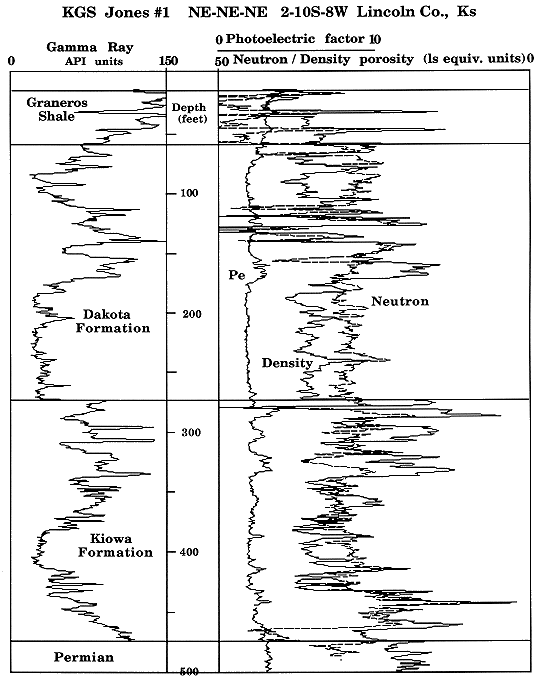
These logs record natural gamma radiation that can be attributed mainly to sources of potassium-40 and radioactive isotopes of the uranium and thorium families. The logs are conventionally recorded in API (American Petroleum Institute) units, which, although arbitrary, do allow consistent comparisons between observation wells. The sandstones of the Dakota aquifer have fairly low radioactivity because they consist mainly of quartz and water and have only minor contents of clay, feldspars, and other accessory minerals. By contrast, the interbedded shales have moderate radioactivity caused by thorium adsorbed on the clay platelets, potassium in the composition of some clays, and variable amounts of uranium generally associated with organic matter and fixed under reducing conditions. Broad distinctions between sandstones and shales are easily made as shown by the gamma-ray log (Figure 10).
Figure 10. Gamma-ray and lithodensity-neutron logs from KGS Jones No. 1, NE NE NE sec. 2, T. 10 S., R. 8 W., Lincoln County, Kansas.
From the gamma-ray log alone it is generally not difficult to select a cutoff value and characterize a section in terms of sandstones (those below the cutoff) and shales (those above). A total thickness of aquifer sandstone can be calculated for the section by finding and measuring the cutoffs. Although this practice is applied commonly, it is only an approximation and can contain serious errors in addition to the subjectivity involved in the choice of the cutoff values. Good aquifer sandstones are characterized not only by shale content but also by significant pore volume and permeability. In practice, there are strong intercorrelations between these properties, so that it is likely that a cutoff value can be established that accommodates all these factors. However, the cutoff should be defined in an objective and consistent manner to reflect the discrimination of aquifers and aquitards indicated on additional logs of porosity and resistivity.
Porosity logs
The calculation of pore volume can be readily made from one of three porosity logs (density, neutron, or sonic) using the same analysis procedures applied in the oil industry. It has become common practice to run a pair of porosity logs (typically neutron and density) to provide some degree of automatic compensation for variations in lithology, which affect porosity evaluation. An overlay of neutron and density logs is shown in Figure 10 for the example Dakota aquifer section, referenced to an arbitrary standard scale of limestone equivalent units. The separation of the porosity log curves reflects their varying responses to the compositions of the sandstone and shale units; a true porosity estimate is approximately midway between the two readings.
By using simple computer methods, the neutron and density logs can be transformed into a volumetric profile of shale, quartz, and water (Figure 11). A comparison with the shale content implied by the companion gamma-ray log shows strong overall similarities to the neutron-density shale profile, even though they are based on radically different properties. Local dissimilarities are caused mostly by variations in clay mineral types and compositions and are useful in more detailed petrophysical studies, as described in the previous annual report.
Figure 11. Gamma-ray and volumetric profile of shale, sandstone, and water based on neutron and density logs from KGS Jones No. 1, NE NE NE sec. 2, T. 10 S., R. 8 W., Lincoln County, Kansas.
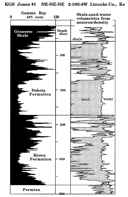
The volumetric profile of water (Figure 11) shows the vertical development in porosity, which is generally of the order of 30% within the major sandstones. The shalier sandstones are generally thinner and have markedly lower porosities. Although the neutron and density logs have added the significant parameter of porosity, the levels of shale and porosity content at which the Dakota sandstone beds cease to be effective aquifer units are still unresolved. Multiple resistivity logs can be applied to this problem, as described in the next section.
Resistivity logs
The recording of multiple resistivity logs is common in oil industry exploration holes, where invasion of formations by drilling mud is considered to be a likely problem in the recording of a true resistivity of the undisturbed formation. The resistivity logging program used in the KGS Jones No. 1 observation hole (Figure 12) is a fairly standard combination for this purpose. The spherically focused (SFLU), medium-induction (ILM) and deep-induction (ILD) resistivity readings represent successively deeper investigations away from the borehole wall. In the conventional situation, where the borehole mud has a lower salinity than the formation water, the more shallow investigation devices will be affected most adversely by the higher resistivity mud filtrate that has penetrated the formation adjacent to the borehole wall. This effect is shown by a separation of the resistivity curves and is a reflection of the degree of invasion.
Figure 12. Gamma-ray, spherically focused (SFL), medium (IFL) and deep (ILD) induction resistivity logs from KGS Jones No. 1, NE NE NE sec. 2, T. 10 S., R. 8 W., Lincoln County, Kansas.
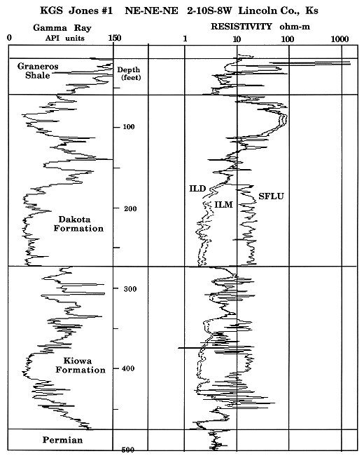
For the purposes of this aquifer study the phenomenon has excellent potential as an indicator of the ability of a bed to transmit water. The practical application can be demonstrated by the resistivity log curves of Figure 12. Note that the thick sandstones of the Kiowa and lower Dakota Formations show systematic resistivity separations, as contrasted with the interbedded shales and shaly sandstones where the effect is minimal. The thick sandstone at the top of the Dakota Formation is differentiated by a small resistivity separation but markedly higher resistivity values. This upper unit contains fresher water in comparison with the more saline waters in the sandstones below (marked by lower resistivities). Thus the resistivity logs also characterize water salinity through the salinity's effect on the formation water resistivity.
Permeability measurements were made on selected core samples from the sandstone units in this well. These data allowed an exploratory analysis of the relationships among permeability, resistivity, porosity, and gamma-ray logs. The depth locations and permeability values of the core samples with reference to the gamma-ray and resistivity logs are shown in Figure 13. Note that the permeability values and their ranges are dictated partly by the size of the core samples, typically with a diameter of 1 in. and 2 in. long. This fine vertical resolution contrasts with that of most logs, which tend to average 2-3 ft of vertical section.
Figure 13. Gamma-ray, spherically focused (SFL) and deep induction (ILD) resistivity logs, together with core measurements of horizontal permeability from KGS Jones No. 1, NE NE NE sec. 2, T. 10 S., R. 8 W., Lincoln County, Kansas.
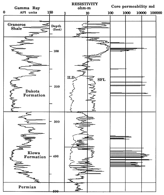
In the following analysis no attempt was made to either smooth the permeability data or adjust the core sample depths to an improved depth registration with the wire-line logs. Thus any relationships that are revealed can be attributed solely to intrinsic and systematic covariation rather than to artifacts of either smoothing or well-intentioned (but inevitably biased) depth adjustments. This stringent approach was feasible because the purpose of the analysis was to validate concepts of interrelationships between permeability and wire-line log readings rather than to develop equations for prediction.
Cross-plots of the logarithms of the raw core permeabilities, the ratio of the two resistivities (SFL/ILD), the porosity computed from the neutron and density logs, and the standard gamma-ray log together with the associated correlation coefficients are shown in Figure 14. The resistivity ratio represents the degree of separation between the shallowest and the deepest resistivity device. As such, it is an ersatz measure of mud filtrate invasion into the formation. The ratio can be used only as an indicator because it is a transient variable, strongly affected by a variety of factors, including the length of time between drill penetration and logging operation, mud weight, and salinity contrast with the formation water.
Figure 14. Cross-plots of raw core permeability (no smoothing, no depth shift), ratio of spherically focused (SFL) to deep induction (ILD) resistivity log, porosity, and standard gamma-ray. Each plot is marked with a correlation coefficient. Data from the lower part of the Dakota aquifer in KGS Jones No. 1, NE NE NE sec. 2, T. 10 S., R. 8 W., Lincoln County, Kansas.
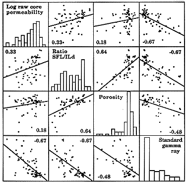
There is a statistically significant and positive correlation (0.33) between the raw permeabilities and the resistivity ratio. This result shows that not only is the resistivity curve separation an indicator of permeability but also its magnitude is a function of permeability. As discussed before, the relationship would be improved through remedial editing of the data: the (nontrivial) operations of appropriate smoothing to ensure common vertical resolution and depth adjustment to give common depth registration between core and wire-line logs.
The weak positive correlation between permeability and porosity (0.18) is probably a reflection of several factors, such as the coarser averaging of the wire-line porosity tools and the restricted range of porosities in the cored intervals. However, the difference in vertical resolution is also true for the gamma-ray tool, whose readings show a stronger negative correlation (-O.67) with permeability. The observations suggest that shale content may be the dominant control on permeability, although porosity effects are included inevitably. When all the correlation coefficients are considered collectively, a simple and consistent pattern emerges. Higher permeabilities are associated with zones that have a greater invasion depth, a lower shale content, and higher porosity.
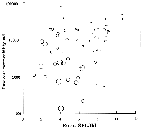
The bubble plot (Figure 15) shows the clear relationship between core permeability and resistivity ratio and their mutual control by shale content, indicated by the gamma-ray log. The gamma-ray log and the shale-sand-water profile shown in conjunction with the shallow (SFL) and deep (ILD) resistivity logs (Figure 16) is a useful summary of these different sources of information. Collectively, they show the lithology, pore volume, formation water quality, and transmissibility characteristics of the Dakota aquifer in this test hole. If the distinction between potential aquifer-aquitard zones can be keyed to shale content, then this criterion can be used to calibrate gamma-ray logs for regional mapping of the aquifer/aquitard discrimination. Note that this discrimination method is based on systematic log indicators of aquifer properties rather than on arbitrary interpretations of lithology.
Figure 15. Cross-plots of raw core permeability (no smoothing, no depth shift), versus ratio of spherically focused (SFL) to deep induction (ILD) resistivity from the lower part of the Dakota aquifer in KGS Jones No. 1, NE NE NE sec. 2, T. 10 S., R. 8 W., Lincoln County, Kansas. The size of the bubbles is determined by the standard gamma-ray log and indicates the degree of shaliness.
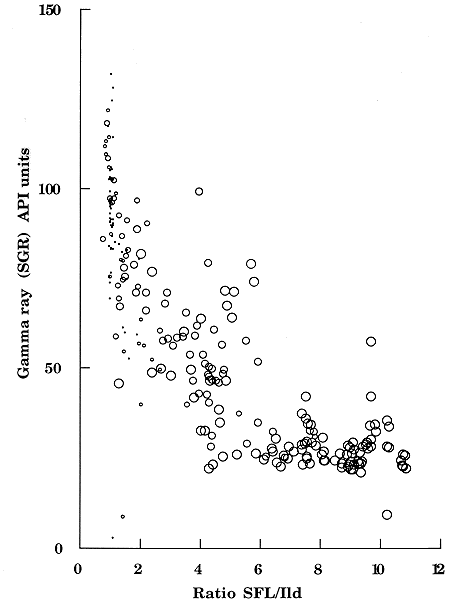
A cutoff value that appears to be the optimum level from a visual inspection of the SFL and ILD resistivity curve separations is marked on the gamma-ray log (Figure 16). In a more systematic analysis a cross-plot was made of the ratio of the two resistivities (SFL/ILD) versus the gamma-ray readings of logs in this well (Figure 17). The hyperbolic cloud of points links a vertical limb of shales and shaly zones of minimal permeability with a horizontal limb of porous, permeable sandstones. The size of the bubbles is determined by the porosity calculated from the density and neutron logs. The more diffuse area between the two limbs is a transitional field that contains a mixture of zones but that commonly has thinner, shalier sandstones with varying degrees of permeability. The spread of the transitional field gives a degree of play to the selection of an appropriate cutoff value to apply to the gamma-ray log. An upper boundary value of 75 API units would classify all permeable zones correctly but would misclassify many poorly permeable zones and so be overly optimistic. A lower boundary value of 45 API units would result in an unduly pessimistic estimate of total aquifer footage as a conservative classification.
Figure 16. Summary of composition, porosity, and permeability characteristics indicated by gamma-ray, lithodensity-neutron, and resistivity logs from KGS Jones No. 1, NE NE NE sec. 2, T. 10 S., R. 8 W., Lincoln County, Kansas.
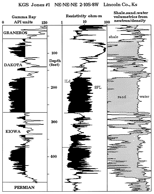
Figure 17. Cross-plot of gamma-ray versus ratio of spherically focused (SFL) to deep induction (ILD) resistivity log from the lower part of the Dakota aquifer in KGS Jones No. 1, NE NE NE sec. 2, T. 10 S., R. 8 W., Lincoln County, Kansas. The size of the bubbles represents the porosity calculated from the neutron and density logs.
In a study of resistivity log combinations and cross-plots from other KGS test holes, a value of 60 API units was chosen ultimately as the most reasonable discriminator. This interpreted effective permeability cutoff was applied to the Dakota gamma-ray log data base in regional mapping studies as the mechanism to calculate net footage of aquifer.
As an alternative approach, each digital gamma-ray log was transformed to a gray-level image strip, where the darkness intensity is a function of the natural gamma radioactivity of the logged formations. In this system sandstones and limestones appear as white or pale gray and shales register as dark gray or black. When hung together on a common stratigraphic horizon and arranged in correct geographic order, the result is a regional gray-level image of the subsurface geology of the Permian to Cretaceous sequence. The major advantage of this approach is that the information is coded in a visual form that is close to a simulation of how the geology would actually appear, when making allowance for the vertical exaggeration. The immediacy of the image should free the observer to focus easily on structural and stratigraphic features of all kinds.
This project is under active development, but provisional plots of the first cross section (T. 16 S.) have been made and are being processed for corrections. A reduced photocopy of the first run is shown in Figure 18 and is indexed with some major stratigraphic units. The original plot shows considerably finer detail, and regional geologic patterns can be traced across the state. The Stone Corral forms a distinct and continuous band at the base of the section. The Cedar Hills Sandstone (Lower Permian) is the most obvious feature in the overlying Permian and appears as a thick wedge that subcrops at the base of the Cretaceous to the east. This is of particular interest to the Dakota aquifer study because saline waters moving upward through the Cedar Hills cause local but major degradation in Dakota water quality in central Kansas. Sandstones at the base of the Cheyenne Sandstone appear to be traceable for considerable distances and contrast with the rather patchy sandstone developments within the Dakota Formation. This is the expected outcome of distributary channel networks and the complex facies mosaics of the delta and coastal plains that deposited the original sediments. The marine transgressive sequence of the Upper Cretaceous (Graneros Shale, Greenhorn Limestone, Carlile Shale) appears as a broad regional band at the top of the section.
Figure 18. Reduced picture of provisional gamma-ray log intensity image of the Permian to Upper Cretaceous in western Kansas along T. 16 S. A larger version of this figure is available.
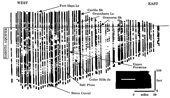
The regionally continuous units in the sequence both above and below the Dakota aquifer form useful visual reference patterns for assessing the internal geometry of the Dakota sandstones and the distinction of real features from artifacts introduced by processing or the discontinuities of the well spacing. It is hoped that the final section images will be informative for a range of many applications, ranging from use as a basic educational exhibit to a conceptual template for realistic computer simulation models.
The original version of the regional image requires remedial processing to remove errors associated with the recording of the gamma-ray logs on which the image is based. The problem can be seen readily as log strip images that appear to be either distinctly darker or lighter than the strip images of adjacent wells. Most of these anomalies are small but are sufficiently distracting to hinder the observer's eye in its ability to trace lateral features. The cause of this problem can be directly attributed to random calibration errors linked to the original gamma-ray logs.
Significant progress has been made recently in normalizing the digital gamma-ray logs through statistical processing. Two stratigraphic units were selected to function as calibration standards: the Graneros Shale for the hot standard (high gamma-ray values) and the Stone Corral for the cold standard. The use of two different standards allows correction of random errors that involve both shift and stretch of the log with respect to its true scale.
The choice of units was based on a geologic perception that major local changes (at a scale less than the distance between section wells) would be fairly minor. Instead, the gamma-ray response of these units would be dominated by a regional trend but confounded by random measurement error. This working hypothesis leads to a quantitative model in which curvilinear trends can be fitted to the raw gamma-ray values of the units to extract regional changes. The appropriate choice of trend can be guided by the statistics of fit and the criterion that the residuals should represent measurement error and thus show no autocorrelation.
The procedure was applied to the Stone Corral Formation by fitting a succession of progressively more complex polynomials. There is little variation in the unit's gamma-ray values when traced across the state, so the significant quartic polynomial trend shows little fluctuation from a constant (Figure 19). The residuals from this trend are essentially random and thus were equated with measurement error.
Figure 19. Plot of mean gamma-ray of Graneros Shale and Stone Corral Formation referenced to east-west coordinate on T. 16 S. The data are fitted with a higher-order spline (Graneros) and a quadratic polynomial (Stone Corral).
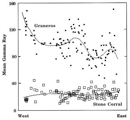
By contrast, the Graneros Shale shows systematic but complex regional changes that could not be absorbed satisfactorily by low-order polynomial trends. In an alternative strategy the Graneros data were fitted with splines: short stretches of cubic polynomials with continuous derivatives at their links. The degree of complexity of the optimum spline fit was chosen as that which resulted in random residuals. The spline curve fitted to the Graneros Shale is shown in Figure 19. More localized features on the curve can be attributed to the influence of Dakota deltaic paleogeography with respect to the line of the section. However, there is a systematic and generalized drift in gamma-ray values moving westward. This aspect reflects the marine transgression of the Graneros from the west and the location of the Cretaceous Interior Seaway in that direction. Increasing gamma-ray values are commonly associated with deeper marine shales and are caused by higher concentrations of uranium fixed by organic matter under reducing conditions.
Measurement error estimates produced at each well have been used to correct digital gamma-ray records in the processing of revised versions of the image section. The final products will provide insight into the regional geometry of the Dakota aquifer and its relationships with the enclosing strata.