Kansas Geological Survey, Open-File Rept. 90-27
Annual Report, FY89--Page 9 of 10
Two areas of potential new water supplies in the Dakota aquifer in west-central and northern Kansas should be investigated to verify their presence and determine their long term viability. In the west-central area, water quality, thickness and proportion of sandstone suggest that the Dakota aquifer may be an important source of water in the future for that area. In northern Kansas, exploration is justified on the basis of lack of geologic, hydrologic and hydrogeochemical data.
(1) Stratigraphic Framework. In the first year of the Dakota program, a useable statewide geologic framework for the strata represented in the Dakota aquifer has been created at the regional level that relates to the depositional history of the Western Interior Cretaceous seaway. As a result, it is now possible to relate lithofacies to depositional environments given sufficient well-control within an area of interest. This means that the framework can be used to generally predict the distribution and trend of sandstone aquifers in the subsurface over large areas. Even so, additional work on the regional level needs to be conducted to define the distribution and relationship of the Lytle and Cheyenne sandstones in Kansas.
In order to make the framework more useful at the subregional and local levels, the geophysical log data base must be expanded and the analysis continued to provide more detail. Along with this, additional test-hole drilling to obtain cores and modern suites of geophysical logs is necessary to uniquely characterize the spatial distribution of lithofacies and depositional environments and formation contacts, particularly in southwest Kansas where surface exposures are limited and in north-central Kansas where the subsurface geologic data base is minimal. Work completed during the course of this first year suggests that by using a diverse combination of lithodensity and natural gamma-ray logs and core samples, it is possible to perform a paleoenvironmental analysis of the lithofacies and establish a consistent rock-stratigraphic framework. This information is important in order to predict the distribution of major sandstone-bearing zones in the subsurface and to locate formation boundaries.
The next phase of analysis of the logs needs to be focused on (1) porosity and permeability estimations based on log response and lithofacies analysis of the Dakota aquifer and (2) developing geostatistical models of the distribution of these parameters in the Dakota aquifer that can be used predictively. In order to do this a data base of porosity and permeability measurements must be created and used as a basis for determining a relationship between log response, depositional environment, and the petrophysical properties of the sandstones. From this the three-dimensional distribution of these properties must be understood and a mathematical framework to describe the variation must be found. It is anticipated that this phase of the research will be greatly facilitated by expanding the geophysical log data base developed during the first year of the program. In the development of these predictive models, the geostatistical work must be closely coordinated with ongoing hydrogeologic studies, so that results may be integrated effectively into ground-water models.
(2) Description of the Flow System. The preliminary results from the first year of the Dakota aquifer program indicate that ground-water flow is directly affected by the hydrostratigraphy and topography of western Kansas. Furthermore, there is evidence to suggest that the flow system is in a transient state due to the slow response of the flow system to erosional, depositional, and tectonic processes that have been active since latest Mesozoic Era time (approximately 67 Ma). In order to develop a more quantitative description of the flow system in the Dakota and other hydraulically connected aquifers, water-level information, media (petrophysical) properties and additional water-chemistry data need to be developed. Previous studies of the Dakota aquifer have largely relied on hydrologic properties estimates from the literature and not from the field. Field investigations should include hydrologic testing of monitoring sites to determine the horizontal and vertical hydraulic conductivities and storage properties, using environmental isotopes to determine the ages and geochemical evolution of ground waters in the system, and more surveying of water levels and water quality in the Dakota and other hydraulically connected aquifers. Estimates of the hydrologic properties will be useful for developing mathematical simulations of the ground-water flow system and the transport of dissolved solutes. Two-dimensional (areal), cross-sectional and three-dimensional flow models can be developed to test hypotheses about the nature of the flow system in the Dakota aquifer, to determine rates of interchange between aquifers, to assess the effects of pumping on water availability and quality and to simulate the effects of water-resource management strategies on the flow system. For example, very little has been done in a quantitative way to determine best way to manage the Dakota aquifer near the edge of the subcrop area in Groundwater Management District 3 in southwest Kansas. The hydrogeology is complex in this area because the Dakota is hydraulically connected to the High Plains aquifer in the subcop area and both aquifers have undergone considerable development. Understanding the controls on the flow system in this area will provide a sound scientific basis for developing management alternatives to be implemented by the ground-water management district. Also important to assessing the future of this aquifer system is the need to quantify recharge to the aquifer from all sources. Along this line it is also important to understand the relationship between the Permian and Dakota aquifers in central Kansas and how this relationship impacts surface waters.
(3) Mechanics of Injection in the Cedar Hills Aquifer. Field tests need to be designed and conducted in order to determine the effects of injection in the Cedar Hills aquifer on the disposal horizon and overlying aquifers. One site should located where the both aquifers are hydraulically connected and another site where they are separated by the Pennsylvanian-Permian aquitard. During testing, carefully-controlled procedures and precise observations of the quantities of fluids injected and fluid pressures in the overlying aquifers must be carried for a long period of time since the aquifers are not very permeable. This would probably entail the installation of several piezometers near an injection well each screened in different aquifers. Alternatively, the application of pulse-testing techniques may provide data of the same quality under more manageable conditions. In any case, monitoring would be continued over time to observe the increase of fluid pressures in the Cedar Hills aquifer from injection and the effects in the overlying aquifers near the brine-disposal well.
(4) Hydrogeochemistry. Much more time was required than planned to correct the variety of errors in the USGS files of water-quality data, the main source of current water-quality data for Lower Cretaceous strata in KWATCHEM. Preliminary work has been conducted to obtain additional data to that now in KWATCHEM for the public water-supply and domestic wells for which the KDHE has information. This process is very time-consuming for each well that was drilled before water well records were required to be kept by Kansas statute since 1976. Paper records must be inspected from different files to first determine wells that are producing primarily from Lower Cretaceous strata, then paper copies of water chemical records must be searched to determine if their are matching sites. More recent data is kept by KDHE on different computer files of well logs and water quality. Matching of computer files to obtain additional chemical data should be easier than the search for paper records. Both of the procedures need to be carried out to complete the water-quality data base in KWATCHEM for the Dakota aquifer.
As much additional detail as possible is needed in the contour plots for TDS and chloride concentrations to better correlate transitions in water quality with hydrogeology. After the additional data from the KDHE are obtained, the contour plots of TDS and chloride will be updated. Several water-quality records do not contain chloride values but do have specific conductance and TDS values. Relationships between TDS, specific conductance, and chloride need to be examined to determine whether additional points could be generated for the chloride contour map by estimating chloride from the relationships.
The hydrogeological and geochemical studies have generated enough new results that examination for a better understanding of interrelationships can be investigated. The examination will allow further refinements of future research needs and directions. For example, the geographic distribution of water-quality data across the Dakota aquifer is uneven in many areas. The distribution of data points needs to be examined in the light of the hydrological and chemical information to determine whether there are wells in the areas of sparse density of points that could be sampled or whether aquifer yield and quality conditions result in poor water supplies in the areas.
Contour plots of dissolved constituents are presently generated by computer with disregard to hydrogeologic boundaries and changing flow paths. Therefore, the shapes of contours may not be as accurate as desired in the vicinity of rivers where stream-aquifer interactions can change ground-water quality patterns over short distances relative to a regional map. The SURFACE III program of the KGS cannot currently calculate contours with considerations of spatial discontinuities such as faults and rivers, although work is in progress to add this capability. If the software is not available in time for the Dakota project, the contours will need to be modified by hand.
The preliminary assessment of water-quality in the Dakota aquifer shows that there are many constituents of drinking-water concern for which there are few data. Part of this is due to the existence of few sites where a complete analysis of all constituents with standards has been conducted. Another reason is that selected chemical characteristics such as radiochemical parameters (for example, radon in water) have only relatively recently become of special concern, and thus were not determined or determined very infrequently in the past. Sampling and analysis of additional well waters used for supplies is necessary for a better assessment of the potability of waters in different areas of the Dakota aquifer.
The distribution of chemical water types indicates a great complexity in water chemistry in some subregions of the Dakota aquifer. The causes for the transitions of one water-type to another or for the presence of a water type in the middle of an area with predominantly another type are not well-known. Better definition of the relative depth position within aquifer strata of the Lower Cretaceous for each of the wells with water-quality data is needed to explain chemical changes in the system. The definition will also aid in improving detail in the contour maps of TDS and chloride concentration.
The presence of Ca-Cl type waters with higher TDS than for surrounding ground waters in some areas of the Dakota aquifer suggests the possibility of oil-field brine contamination. These locations need to be examined to determine whether the origin of the water chemistry is predominantly from natural or anthropogenic causes. Where pollution from oil or gas brines is suggested, additional sampling and analysis involving the mixing curve approach of Whittemore (1984, 1988) could be used to identify salinity sources. The influence of any oil brine contribution to the water chemistry of a site could then be subtracted to give the true natural water type and chloride and TDS concentrations.
The study of chemical trends along flow paths was made on the basis of data selected from the U.S. Geological Survey data files before the review of these and additional data were completed and placed into KWATCHEM. The broad generalizations made with the data are for chemical changes in two dimensions. The understanding of the chemistry of flow paths in three dimensions requires more closely spaced sampling points for which precise information is available about the sampling-depth location within the aquifer. Along each of the flow paths, appreciable changes in the water chemistry are evident downgradient of the subcrop of the Cedar Hills Sandstone. In order to better understand mixing between the fluids from the Cedar Hills and the Dakota, a better understanding of the chemistry of the Cedar Hills fluids is mandatory. The few samples available from the Cedar Hills Sandstone show variability in the chemistry in the deeper aquifers. Additional sampling of the deeper aquifers should be concentrated in the vicinity of the Cedar Hills subcrop where waters probably leak into the Dakota. The flow-path study also suggested possible cementation by quartz or chalcedony and dissolution of carbonates because of mixing of deeper fluids with Dakota Formation fluids. The mixing could be modelled in order to evaluate the extent of cementation or generation of porosity and possibly to estimate the end-member compositions of the mixing fluids, especially in the area of the Cedar Hills subcrop.
Due to the paucity of stable-isotope data available for waters from different formations in Kansas, it is difficult to determine mixing scenarios between units to determine if water-mineral interactions or solely mixing of waters is occurring between units, and to determine sources for some of the saline waters that are found in the Dakota. An additional use for isotopes would be to correlate isotopic signatures of the water with corresponding isotopic values from the aquifer materials. This information might permit identification of Pleistocene or older recharge. Use of environmental isotopes such as tritium in areas of known fracture flow situations would permit estimations of recharge rates of precipitation from the mid-1950's to mid-1960's. Additional isotope data, as well as minor-element mixing curves and geochemical modelling, will help determine the flow regime and chemical evolution history responsible for the present chemistry distribution in the Dakota aquifer.
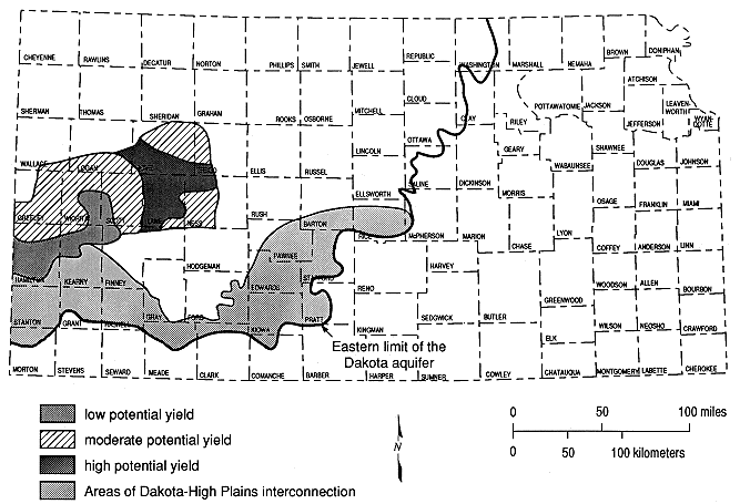
(5) Evaluation of Areas of the Dakota Aquifer Not Presently Under Development. Two areas of the Dakota aquifer in Kansas have been identified that should be explored in order to more fully evaluate their potential for additional water supply in the future. On the basis of water chemistry, total formation thickness and proportion of sandstone in the Dakota Formation, a primary area for further investigation includes a large part of west-central Kansas covering parts or all of Gove, Trego, Logan, Greeley, Wichita, Scott, Lane, Ness, Finney, Kearny and Hamilton counties (Figure 10.1). In these areas the ground waters from the Dakota aquifer appear to contain low concentrations of dissolved solids and chloride. Additionally, within this area of potential development, the thickness of and proportion of sandstone in the Dakota aquifer is greatest in Lane and parts of western Ness, southern Gove and a small part of southeastern Logan counties. In Figure 10.1, the area of potential development is subdivided according to probably yield of water to wells into low, moderate and high categories on the basis of the proportion of sandstone in and thickness of the upper part of the Dakota aquifer (Dakota Formation). The other area of Kansas where some exploration may prove useful is in Jewell, Smith and Phillips counties. In these counties there is little if any geologic, hydrologic or hydrogeochemical information on the Dakota aquifer, due to more accessible sources of water from High Plains aquifer and stream-aquifer systems.
Figure 10.1. Potential area of future water development from the Dakota aquifer.