Kansas Geological Survey, Open-File Rept. 90-27
Annual Report, FY89--Page 9 of 10
During FY90-92 the program will concentrate on areas where the aquifer is presently under development in southwest and central Kansas. In these areas, irrigated agriculture, public water supplies, and industry rely heavily on the Dakota and overlying aquifers. Up-to-date information is needed to fully evaluate the water-resources potential of the Dakota aquifer in these areas for water planning and management. The potential impact on the Dakota aquifer of shallow underground injection of oil-field brines into the Cedar Hills Sandstone also needs to be addressed. With the completion of this phase the consequences of various water-management scenarios can be tested for the developed areas of the Dakota aquifer.
The emphasis of the program will then shift to the deeper subsurface of western Kansas in FY93. In this area readily available data are sparse and the depth to the top of the Dakota aquifer is considerable. As a result, most of the program's attention will be focused on those areas of potential aquifer utility adjacent to the present study areas, especially in Greeley, Hamilton, Kearny, Wichita, Scott, Lane and Gove counties in southwest and west-central Kansas and in Jewell, Smith and Phillips counties in northern Kansas. Concerns in the northwest Kansas area are primarily related to the quality of ground water in the Dakota aquifer. A preliminary analysis indicates considerable potential for water-resources development in Lane, Scott, Wichita and Gove counties.
Figure 11.1 shows the subdivision of the geographic extent of the Dakota aquifer in Kansas into subregions and the timing of research activities for these subregions. Also shown on the figure is the study area of the Kansas Corporation Commission-funded study of the Dakota aquifer in central Kansas, including the ground-water management districts. Initial estimates of program length in the original planning document (Macfarlane, 1988) called for the total length of the program to be 14 years. With the completion of the first year it appears that the program can be completed fully in eight years, depending on the level of detail sought where the Dakota aquifer is in the deeper part of the subsurface. Figure 11.2 shows the major program activities to be carried out during the life of the program.
Figure 11.1. Dakota aquifer program subareas of investigation.
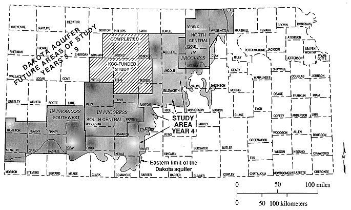
Figure 11.2. Program elements of the Dakota aquifer program and their timing
The first part of the subregional characterization will concentrate on areas where the aquifer is presently under development in southwest and central Kansas (years two through four and the first half of year five; Figure 11.2). In this area the Dakota aquifer is present at the surface or subcrops beneath the High Plains aquifer and stream-aquifer systems. The aquifer is used extensively for irrigation, industrial, public water supply, stock, and domestic uses. In order more easily manage the research activities, the area is further subdivided into southwest, south-central and north-central subregions focusing on areas of heaviest use. Research in these subregions is expected to take approximately two years in the south-central and north-central subregions and two and a half years for the southwest subregion. During the last year of this phase, work will begin in the remaining subcrop-outcrop area outside of the subregions identified in southwest and central Kansas in order to integrate all of the results in this area presently undergoing development. At this point the data from all of the completed subregional projects will be used to characterize the hydrogeology of the Dakota aquifer in the developed area. The results of this integration are expected to be completed sometime during year five of the program and will be used to conduct water-management studies fo the developed portion of the Dakota aquifer using computer simulation. The simulation of water-management scenarios will be completed during year six of the program. These studies will be used to address the more immediate water-management needs of State and local agencies in those areas where the Dakota aquifer is presently undergoing development.
The research direction of the program will then shift to the deeper subsurface of northwest Kansas (Figure 11.2). In this area, readily available data are sparse and the depth to the top of the Dakota aquifer is considerable. As a result, most of the program's attention will be focused on those areas adjacent to the outcrop-subcrop area, especially in Greeley, Hamilton, Kearney, Wichita, Scott, Lane and Gove counties in southwest Kansas and in Jewell, Smith, and Phillips counties in northern Kansas. Concerns in this northwest Kansas area are primarily related to the quality of ground water in the Dakota aquifer. In order to address these concerns the program emphasis will be on data collection from monitoring sites constructed in the Dakota aquifer and drill-stem tests of the aquifer in this area.
To accomplish this goal it will be necessary to define the geologic framework and characterize the chemical quality, movement, and availability of ground water in the Dakota aquifer on a subregional basis. During the second year of the program, reconnaissance-level investigations to characterize the water resources of the Dakota aquifer in each of the sub-areas of investigation will be initiated and completed by the Kansas Geological Survey and cooperatively with the U.S. Geological Survey. In the second year of the program, test hole drilling and logging will be used to bring the regional geologic framework down to the subregional level in the subareas. During the third year, field work will be used to more closely characterize the hydrology of this aquifer in areas with limited data availability or possible hydraulic interconnection with other aquifer systems. Monitoring sites will be selected to observe hydrologic and chemical quality conditions at several levels in the regional ground-water flow system and to perform hydrologic tests in order to determine rates of water movement between aquifers. Work is expected to continue into the fourth year of the program in the southwest subarea in order to finish collecting and analyzing water samples from the piezometers.
With the completion of this work in the subregions and with the results of the earlier Corporation Commission funded study, a substantial portion of the Dakota aquifer will have been examined in detail through individual projects. More importantly, the geographic area covered by these projects is where the aquifer is widely used as a source of water. Beginning in the fourth year of the program an effort will be made to integrate the findings from previous work in the program in order to tie all of the subregions together with data from the remainder of the subcrop-outcrop area. The primary thrust during this time will be to develop computer simulations of ground-water flow and of the transport of dissolved solutes. These will be used predictively to assess the impact of various water-resources management scenarios. This phase of the integration process will be carried out simultaneously as reconnaissance-level investigations of the Dakota aquifer in northwest Kansas outside the outcrop-subcrop area begin.