Kansas Geological Survey, Open-File Rept. 90-27
Annual Report, FY89--Page 8 of 10
Energy cost for pumping is one of the major variable costs in irrigated crop production in Kansas. About 3.5 million acres of land are irrigated annually with an estimated 5.12 million acre-ft of water. Approximately 2/3 of this area is surface-irrigated, primarily using furrows to conduct the water through the field, and the remainder is sprinkle-irrigated using center pivots. The power sources for pumping are also variable. Natural-gas engines predominate with 59% of the total. Electric motors are second with 19%, followed by diesel engines at 15% and Propane or LPG at 7%. Energy use is directly related to the depth to water in the well under static, non-pumping conditions. As a result, energy use is highest in southwest Kansas where the depth to water is greatest.
All of these estimates of recoverable ground water in storage were based on limited information and regionalized values of storage and thickness of the Dakota aquifer and, as a result, may be substantially in error. Similarly, water use in the Dakota aquifer is also difficult to ascertain with any degree of accuracy due primarily to a lack of reporting and monitoring of water production by state agencies and groundwater management districts. The most reliable data come from public water supplies in Kansas which comprises a fairly small proportion of the total amount of water produced from the aquifer.
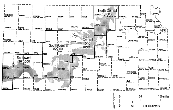
Nonetheless, Figure 9.1 shows the estimated yearly average volume of water pumped from the Dakota aquifer since 1940. The data for each decade are plotted at the midpoint of the decade. The water-use data used in the figure for the1940-1980 period came from the U.S. Geological Survey CMRASA program (Spinazola et al., 1987). Data for the 1980-1987 period were derived assuming that (1) existing water wells during the previous decade were still in operation producing water at the same rate during the 1980's, (2) additional wells drilled during the 1980's added incrementally to the total amount of water produced during the previous decade, and (3) the average amount of water appropriated during the 1980's is equivalent to the actual amount of water pumped. Using the same data, Figure 9.2 shows the estimated water use from the Dakota aquifer by subregion for the 1980's.
Figure 9.1. Estimated average annual total volume of water used from the Dakota aquifer in Kansas by decade for the period 1940-1987, including all major and minor users.
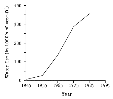
The development of water resources in the Dakota aquifer statewide (Figure 9.1) has a history similar to that of the High Plains aquifer in Kansas. Prior to 1940, the Dakota aquifer was used primarily for domestic and to a limited extent public water supply use. In the 1960-1970 decades, water production increased dramatically from approximately 28,000 to more than 285,000 acre-ft. Most of this increase was for irrigated agriculture in southwest, south-central, central, and north-central Kansas with minor increases for public water supply and industry. In the late 1970's, concerns about over-development of the High Plains aquifer in southwest Kansas prompted Groundwater Management District 3 to restrict development of this near-surface aquifer. This has caused a number of users to drill new wells in the Dakota aquifer consequently increasing the total number of high-capacity wells in the Dakota aquifer in southwest Kansas (Dealy et al., 1984). Figure 9.2 shows that the Dakota aquifer has the heaviest use in the southwest subregion and whereas the least use is in the central subregion. Even so, the largest withdrawals of water come from the overlying High Plains aquifer. The CMRASA data show that approximately 5% of the total water used in the north-central, central, south-central, and southwest subregions comes from the Dakota aquifer.
Figure 9.2. Estimated total volume of water appropriated from the Dakota aquifer for the period 1980-1987 in Kansas by region.
Energy use is one of the major variable costs in producing water from the Dakota aquifer in Kansas. Water is produced from wells by pumps powered by a wide variety of energy sources. The source of energy used is driven by local availability in Kansas. For example, many of the pumping plants are powered by natural gas-driven engines in southwestern Kansas due to the proximity of the Hugoton gas field. Overall, pumping plants powered by natural gas predominate, making up 59% of the total; followed by electric power, 19%; diesel fuel, 15%; and propane or LPG, 7%. Depth to water, pumping depth, pressure developed in the transmission lines, and efficiency of the pumping plant all affect energy use in the production of water. Deeper pump settings, higher system pressures, and lower pumping- plant efficiencies all contribute to high rates of energy use. The depth of the pump setting in the well is a function of the transmissive properties of the aquifer, the design of the well, the rate of discharge, and the type of pump. Table 9.1 is a summary of results from a field survey conducted to determine energy use in the Dakota and the hydraulically connected Dakota-High Plains and Dakota-alluvial aquifers using high-capacity wells. The table shows the amount of electric power or fuel required to pump one acre-foot of water from these three categories of aquifer type. Table 9.2 is a summary of results from previous investigations of energy use in high-capacity wells tapping alluvial, High Plains and Dakota aquifers in Kansas. Both tables indicate that electric power or fuel consumption is directly related to the depth to water in the well. Depth to water generally increases from shallowest in wells tapping alluvial aquifers to deepest in the High Plains and hydraulically connected High Plains and Dakota aquifers in southwest Kansas. Further discussion of the results of this field investigation can be found in Appendix D.
Table 9.1. Summary of results from a 1989 field survey of energy use in high capacity wells that withdraw water from the Dakota aquifer and the Dakota and other hydraulically connected aquifers in Kansas.
| Aquifer | Electric Power (Kwh) | Natural Gas (MCF) | Propane (Gal) | Diesel Fuel (Gal) | ||||
|---|---|---|---|---|---|---|---|---|
| Average | Range | Average | Range | Average | Range | Average | Range | |
| Dakota | 495 | (868-156) | 8.07 | (10.9-6.48) | 62.5 | (82.0-42.6) | 58.7 | (62.5-15.8) |
| N | 17 | 6 | 4 | 11 | ||||
| Dakota- High Plains |
1858 | (2560-252) | 12.2 | (17.4-5.14) | ||||
| N | 5 | 27 | none | none | ||||
| Dakota- Alluvial |
370 | (445-295) | 6.44 | (7.17-5.71) | 25.2 | (34.4-16.1) | ||
| N | 2 | 2 | none | 6 | ||||
| Average | 768 | 11.2 | 62.5 | 46.9 | ||||
| N | 24 | 35 | 4 | 17 | ||||
Table 9.2. Summary of results from previous field investigations of energy use in high-capacity wells withdrawing water from alluvial, High Plains, and Dakota aquifers in Kansas.
| Aquifer | Source of Data | Electric Power (Kwh) |
Natural Gas (MCF) |
Propane (Gal) |
Diesel Fuel (Gal) |
|---|---|---|---|---|---|
| High Plains | Dealy and Jenkins (1980) |
403 N=1 |
8.71-3.80 N=5 |
Figures 9.3 through 9.9 are hydrographs of monitoring wells in the Dakota vertically adjacent aquifer and aquitard systems in Kansas. A limited number of these "representative" hydrographs have been selected for discussion here to draw attention to the response of the Dakota aquifer to increased withdrawals of water in the 1970's and 1980's and to show the hydraulic head relationships between aquifers where they are hydraulically connected.
Figure 9.3 is a hydrograph of a nest of monitoring wells screened in the Arkansas River alluvial aquifer and the High Plains and Dakota aquifers in east of Holcomb in the Arkansas River valley, Finney County. At this location the Dakota and High Plains aquifers are vertically adjacent and hydraulically connected. The record consists of yearly measurements of water levels in each aquifer. During the period of record, water levels in the deeper aquifers respond in concert with long-term changes in the water table of the alluvial aquifer. The hydraulic-head differences between the monitoring points indicate that the direction of water movement is downward from the alluvium into the deeper aquifers. Prior to 1983, water levels in the Dakota piezometer were, for the most part, higher than water levels in the High Plains aquifer and the flow of water was from the Dakota to the High Plains aquifer. In 1983 the vertical flow direction changed, probably due to nearby pumpage from the Dakota aquifer at Holcomb. Since then water levels in the High Plains aquifer are approximately 10 ft. higher than those in the Dakota aquifer and the vertical flow direction is from the High Plains aquifer to the Dakota aquifer.
Figure 9.3. Hydrograph of a nest of piezometers in a monitoring site located in SE, SW, SW Sec. 9, T24S, R33W.
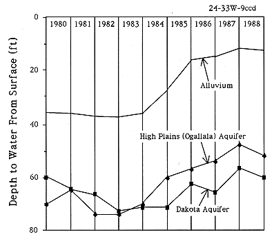
Figure 9.4 is a hydrograph of an observation well screened in the Dakota aquifer in Ford County within a two miles of Sawlog Creek. The Dakota aquifer is confined by the overlying Upper Cretaceous aquitard. The well site is located near a concentration of high-capacity wells screened in the upper portion of the Dakota aquifer (Lobmeyer and Weakly, 1979). The time-series data show many high-frequency and high-amplitude fluctuations related to seasonal withdrawals of water from the Dakota aquifer. Since 1977 the annual range of water levels in the monitoring well has been approximately 15 to 20 feet with nearly complete recovery between irrigation seasons, suggesting induced recharge from Sawlog Creek or other sources. However, from 1972-1976 superimposed on these annual water-level fluctuations which exceeded 25 ft. on the average is a downward trend in the hydrograph.
Figure 9.4. Hydrograph of a monitoring well located in NW, NW Sec. 12, T25S, R23W.
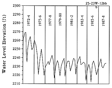
Figure 9.5 is a hydrograph of an irrigation well screened in the Dakota aquifer just east of the Hodgeman-Finney County line. At this location the Dakota aquifer is confined by the Upper Cretaceous aquitard. The nearest high-capacity well is located approximately 4.5 miles northwest of this observation point. The hydrograph shows a steady decline of water level in the observation well through the 1970's and early 1980's. The hydrographs of other observation wells in Hodgeman and Ford counties show similar patterns of water-level decline. The water-level decline in this hydrograph and the in the early portion (1972-1976) of the previous one indicates a long-term decrease in the total amount of water in storage under confined conditions. A seasonally fluctuating but relatively stable water level for the 1977-1988 period in Figure 9.4 suggests a decrease in the rate of withdrawal or recharge to the aquifer in the vicinity of the well.
Figure 9.5. Hydrograph of an irrigation well located in SW, SW, SW Sec. 7, T23S, R26W.
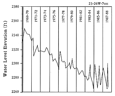
Figure 9.6 is a hydrograph of water levels recorded in a nest of two piezometers in Pawnee County, a few miles south of the Pawnee River. At this site, the Dakota aquifer is confined by a thin Upper Cretaceous aquitard. Nearby, the Dakota aquifer is hydraulically connected to an overlying water-table aquifer. Over the long term, water levels in the upper part of the Dakota aquifer are stable even though the seasonal water-level declines are on the order of 25 to 50 ft. These declines are probably related to Burdett's increased water demand in the summer months and to summer pumpage of water for irrigation to the west in Hodgeman County. Water-level data for the Permian aquitard are limited to 1978-79 period but show that water-levels in the Permian aquitard are above land surface indicating flowing artesian conditions (land surface elevation at this site is 2100 ft.). Water levels in the underlying Cedar Hills aquifer are within a few tens of feet of land surface at this location (Kansas Corporation Commission, 1986).
Figure 9.6. Hydrograph of a nest of piezometers screened in the Dakota aquifer and Permian aquitard located in NE, NE, NE Sec. 7, T22S, R19W.
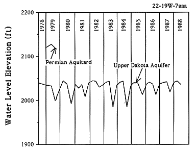
Figure 9.7 is the hydrograph of an observation well screened in the upper part of the Dakota aquifer in southwest Ellsworth County. The Dakota aquifer is overlain by a water-table aquifer in the Pleistocene deposits at this location. This observation well is located less than a mile away from an irrigation well that was drilled in the early part of 1976. The hydrograph of the observation shows very distinctly the seasonal effect of pumpage from the irrigation well on the Dakota aquifer. Prior to 1976 water levels fluctuated somewhat irregularly over a 25-ft range. Since then high frequency and high amplitude fluctuations characterize the well hydrograph. The maximum range of variation in water levels is approximately 60 ft. for this time period. The hydrograph also provides evidence that the pumpage from the irrigation well is not reducing the amount of water in storage in the aquifer.
Figure 9.7. Hydrograph of an observation well located in SW, NW Sec. 21, T17S, R9W.
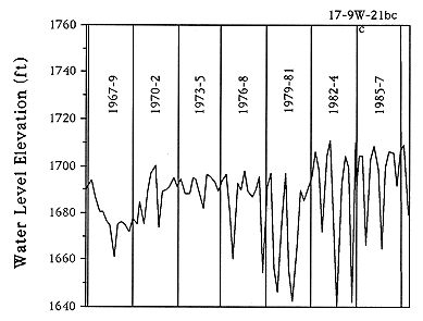
Figure 9.8 is a hydrograph of water levels in an irrigation well located a few miles north of the Republican River in Cloud County. At this location the Dakota aquifer is at the surface and is unconfined to partially confined. Over the period of record from 1970-1988 there water levels in the well have remained stable for the most part but showing seasonal declines associated with pumpage. The 1984-88 portion of the record shows a general rise in water levels possibly associated with increased precipitation for the period, a decrease in pumpage, or both. Water levels during this period appear to be more stable than the previous portion of the record due to less frequent measurements during 1984-1988.
Figure 9.8. Hydrograph of an irrigation well located in NE, NW Sec. 1, T5S, R2W.
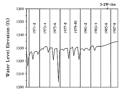
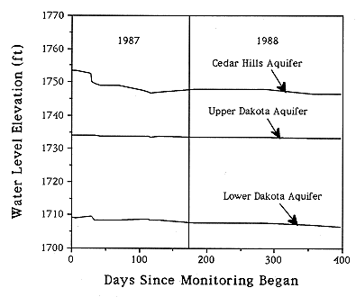
Figure 9.9 is a hydrograph of a monitoring well nest in Russell County near Gorham. The nest consists of a multiple-completion well with piezometers screened in the upper and lower Dakota aquifer and the Cedar Hills aquifer (Macfarlane et al., 1988). At this location, the Dakota aquifer is hydraulically connected to the underlying Cedar Hills aquifer and the Dakota aquifer is confined by the Upper Cretaceous aquitard. For the 1987-88 monitoring period, very little change in water levels is evident in any of the piezometers because these aquifers are unused in the vicinity. Water levels are highest in the Cedar Hills aquifer indicating upward movement of water from the Cedar Hills aquifer into the lower portion of the Dakota aquifer. The water level in the upper Dakota aquifer is higher than in the lower, indicating downward movement of waters from the upper into the lower Dakota. Thus, at this site there are mutually opposed vertical flows of water in the shallow subsurface. This phenomenon is discussed further in the section, The Regional Ground-Water Flow System in Western and Central Kansas With Reference to the Dakota Aquifer (Chapter 5).
Figure 9.9. Hydrograph of piezometers in a multiple-completion monitoring well near Gorham, Kansas, SW, SW, NW Sec. 32, T13S, R15W.
On the basis of the available historical water-level data, the hydrographs presented above are representative of the changes that have taken place in the Dakota aquifer over time. Water-level declines have occurred in southwest Kansas and not elsewhere due to the greater rates of withdrawal from the Dakota and High Plains aquifers in that part of the state. The results of simulations of a range of ground-water management options in the southwest Kansas area show that as development of both aquifers continues, water levels in the Dakota aquifer will continue to decline. This will occur because the amount of water withdrawn from the aquifer will exceed the rate of recharge from the overlying High Plains aquifer and, as a result, water will be removed from storage (Watts, 1989).