


Kansas Geological Survey, Open-file Report 88-39
Great Plains and Cedar Hills Aquifers--Page 20 of 25
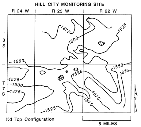
The Hill City monitoring site is located in central Graham County west of the Central Kansas uplift in the Western Kansas basin. Thin deposits of loess mantle the upland areas near the site. The near surface bedrock is the Smoky Hill Chalk Member of the Niobrara Chalk. Figures 38 and 39 show the configuration of the top of the Carlile Shale and the Dakota Formation, respectively, in the vicinity of the monitoring site. The near surface rocks dip to the northwest at 10 to 15 feet per mile in the well site vicinity. Additionally, an aligned series of structural lows on the top configuration maps is coincident with a remote sensing lineament. This suggests that the site may be located near a fracture system that has some surface expression. A similar, aligned series of structural lows in the bedrock occurs in northwest Graham County (Merriam, 1963). These structural lows are reflected at least to the top of the Stone Corral.
Figure 38. Configuration of the top of the Carlile Shale in the vicinity of the Hill City multiple-completion monitoring well.
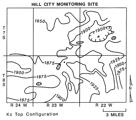
Figure 39. Configuration of top of the Dakota Formation in the vicinity of the Hill City multiple-completion monitoring well.
7.3.2 Arrangement of the Piezometers
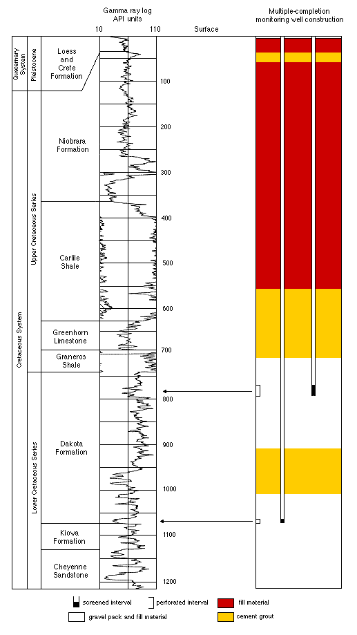
The multiple-completion monitoring well at the site consists of a 1.5-in. OD and a 2-in. OD piezometer in a 5.5-in. OD steel-cased borehole. The piezometers monitor two intervals in the upper part of the Great Plains aquifer (Dakota Formation): 773-797 feet and 1063-1075 feet below the top of the casing. The 1.5-in OD piezometer is used to monitor the lower zone and has ten feet of well screen at the bottom of the piezometer. The 2.0-in. OD piezometer is used to monitor hydrologic conditions in the upper zone and has 25 feet of well screen at the bottom of the piezometer. The construction of the multiple-completion monitoring well is shown schematically in Figure 40. Construction at the Hill City site began on August 22 and was completed by August 26, 1987.
Figure 40. Construction and location of monitored zones, Hill City multiple-completion monitoring well.
7.3.3 Hydrologic Conditions
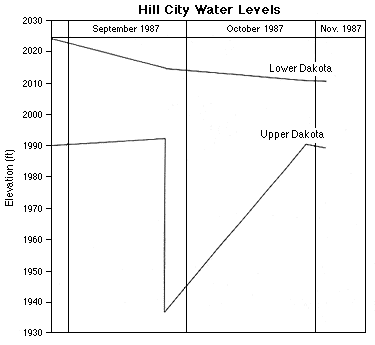
At the Hill City monitoring site the hydraulic head of the lower part of the Dakota Formation (upper part of the Great Plains aquifer) is approximately 20 feet higher than the hydraulic head in the upper part of the Dakota Formation. Figure 41 shows the hydrographs of the two piezometers at the Hill City site for the period of monitoring from the later part of August through November, 1987. The large decline in water level in the upper piezometer near the end of September was caused by pumpage from the upper piezometer. Measurements were taken before and immediately after pumping, and then again near the end of October. This piezometer was pumped for approximately two hours small hand bailer to remove 20 gallons of water. Note that the approximately 55 feet of decline in the upper piezometer has caused a very slight (0.3 ft.) decline of water level in the lower piezometer. These piezometers are separated vertically by approximately 266 feet of interbedded mudstones, claystones, and thin- bedded sandstones.
Figure 41. Hydrographs of the piezometers, Hill City multiple-completion monitoring well.
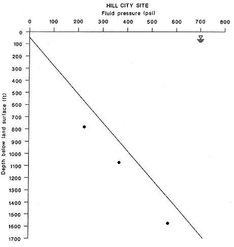
Like the Gorham site, the upper part of the Great Plains aquifer (Dakota Formation) is also under subhydrostatic pressure conditions. Figure 42 is a plot of the fluid pressures in the upper part of the Great Plains aquifer measured in the piezometers at the Hill City site. Included in the diagram is the estimated fluid pressure in the Cedar Hills aquifer beneath the monitoring site based on reported fluid levels. The fluid pressure-depth ratios increase with depth and range from 0.31 to 0.37 psi/ft.
Figure 42. Profile of fluid pressure versus depth, Hill City multiple-completion monitoring well.
These results are difficult to interpret considering the limited water-quality information available as of this writing. The chloride concentration of the water sample taken from this piezometer is 485 mg/l. During June, 1987, a water sample was obtained from an oil-field water supply well tapping the lower part of the Great Plains aquifer (lower Dakota, Kiowa, and Cheyenne). The chloride concentration of the water sample was 304 mg/l. The static water level in this well is approximately 385 feet lower than the water table elevation in the overlying High Plains aquifer. The fluid pressure-depth ratio for this well which is constructed with a long screened interval is 0.27 psi/ft.
It is readily apparent from the fluid pressures and water levels that the Great Plains aquifer is not well connected to the near surface hydrologic system in Graham County. However, near-surface geologic structures suggest that fractures may provide pathways for water moving down from the High Plains aquifer into the Great Plains aquifer. Furthermore, the chloride concentration of ground waters in this part of the Great Plains aquifer are unexpectedly low for a deep, confined aquifer system. If these pathways are present, then the fluid pressures in the Great Plains aquifer should not be subhydrostatic. This suggests the possibility that these freshwaters may be very old. 7.3.4 Ground-Water Geochemistry
A representative water sample has only been collected from the upper piezometer in the Upper Dakota aquifer. The chemical type of the water is sodium-calcium-chloride. Dissolved constituents concentrations indicate that cation exchange and associated carbonate solution have not been important in the origin of the water chemistry. Constituent ratios and location on plots of constituent relationships such as Figures 27, 28, and 31 show that the water is similar to other waters that have not been appreciably affected by cation exchange that were collected from the Great Plains aquifer system to the east as a part of this study. An interference in the sample precluded an accurate determination of the bromide concentration. Additional treatment of the sample is planned to attempt to remove the interference.
Previous page--Gorham Monitoring Site ||
Next page--Hays North Monitoring Site
Start of Report ||
Report Contents