


Kansas Geological Survey, Open-file Report 88-39
Great Plains and Cedar Hills Aquifers--Page 21 of 25
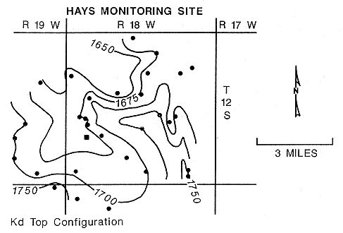
The Hays North monitoring site is located in northern Ellis County on the east flank of the Stockton Anticline, near the axis of a northwest-plunging syncline (Figure 43). The near surface rocks in the vicinity of the well site dip to the southwest at approximately 50 to 70 feet per mile. Northward extension of a remotely-sensed lineament along the trend coincides with the steeply dipping east flank of the plunging syncline and linear segments of the North Fork, Big Creek stream channel. At the surface the unconsolidated Ogallala Formation mantles the upland area around the well site. The bedrock below the Ogallala is the Fort Hays Member of the Niobrara Chalk.
Figure 43. Configuration of the top of the Dakota Formation in the vicinity of the Hays North multiple-completion monitoring well.
7.4.2 Arrangement of the Piezometers
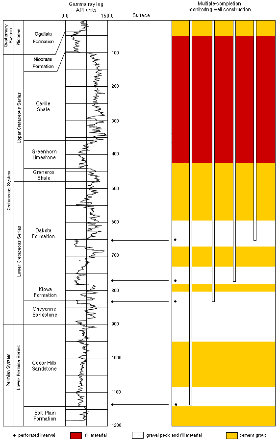
Four piezometers have been placed inside the steel-cased borehole at the Hays North site. Figure 44 is a schematic of the well construction at the site. Piezometers were placed in the hole to monitor hydrologic conditions in the Great Plains aquifer at three intervals (upper and lower Dakota, and the Cheyenne) and in the Cedar Hills aquifer: 650-660, 766-776, 830-840, and 1130-40 feet below the top of the casing. For each piezometer the upper 400 feet of pipe is 2-in. OD and the lower segment down to total depth is 1.5-in OD.
Figure 44. Construction and location of monitored zones, Hays North multiple-completion monitoring well.
7.4.3 Hydrologic Conditions
At the Hays North site, a shallow water-table aquifer is present in the Ogallala. Depth to water at the site is approximately 5 feet and nearby streams appear to be spring fed by the Ogallala in the upland areas. Saturated thickness at the site is estimated to be on the order of 30 feet. The Codell Sandstone aquifer is present and is used for water supply by many of the farmsteads near the site. The elevation of the Codell potentiometric surface, computed from the static water-level in a well less than one mile south of the site was 2143 feet above mean sea level on November 3, 1987.
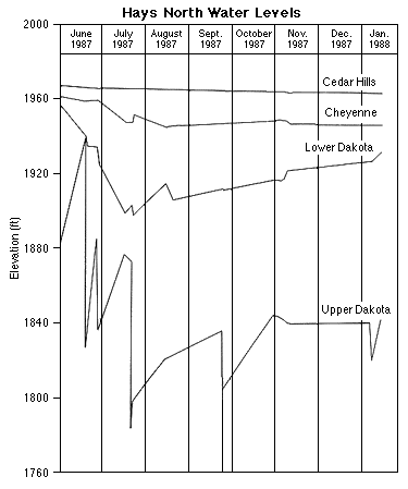
At the Hays North site, the vertical direction of ground-water flow is upward within the Cedar Hills and Great Plains aquifers. The hydrographs of the piezometers at the site show that water levels in the Cedar Hills aquifer are approximately 125 feet higher than water levels in the upper part of the Great Plains aquifer (Figure 45). Fluctuations of water level in the upper Dakota are mostly the result of pumpage in the upper Dakota piezometer. Note that pumpage in this piezometer has an effect on water levels in the lower Dakota piezometer suggesting interconnection. The decline and long-term rise of water levels in the upper and lower Dakota piezometers appear to be the result of pumpage from nearby domestic and stock wells using the Dakota (upper part of the Great Plains aquifer) for water supply. The low water levels in July suggest that the rate of withdrawal of water was much higher during the summer than later in the year. The increased rate of withdrawal may also have affected water levels in the Cheyenne during July since these water levels show a similar trend.
Figure 45. Hydrographs of the piezometers, Hays North multiple-completion monitoring well.
Neither shallow disposal of oil-field brines nor the increased withdrawal of water from the upper part of the Great Plains aquifer appear to have affected the water levels in the Cedar Hills during the more than seven months of monitoring. However, pumpage of the Cedar Hills appears to significantly affect water levels in the Cheyenne. Figure 46 shows the decline of water levels in the Cheyenne piezometer as the Cedar Hills piezometer was pumped using an air compressor during well development. Steady water-level declines were recorded in the Cheyenne until the air compressor was turned off at which time water levels in the Cheyenne recovered.
Figure 46. Response of the water level in the Cheyenne piezometer to pumpage in the Cedar Hills piezometer, Hays North multiple-completion monitoring well.
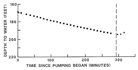
During the approximately 280 minutes of pumping the total water-level decline in the Cheyenne piezometer was approximately 24 feet. The total drawdown in the Cedar Hills piezometer from pumping is estimated to have been approximately 100 feet based on water-level measurements made during recovery in the pumped piezometer. This preliminary data and the longer-term water-level fluctuations of the piezometers suggests that the Cedar Hills and Great Plains aquifers are hydraulically-interconnected and behave as a single system at the Hays North site.
A comparison of water levels in the Cedar Hills and Great Plains aquifers with water levels in the Ogallala and Codell Sandstone indicates that the deeper, confined aquifers are relatively isolated from the near-surface hydrologic environment. The potentiometric surface of the Cedar Hills aquifer, although with the highest hydraulic head, is approximately 75 feet lower (or 45 feet lower, using a fresh-water equivalent hydraulic head value) than the potentiometric surface of the Codell Sandstone.
7.4.4 Ground-Water Geochemistry
The waters sampled from the four zones at the monitoring site vary little in their major and minor constituent chemistry, except for somewhat higher concentrations of calcium, strontium, and bicarbonate relative to chloride in the water from the upper Dakota aquifer in comparison to those in the other three zones. The range in the ratios of Br/Cl, B/Cl, and I/Cl for the samples are within the analytical error. The location of points for the waters on Br/Cl and I/Cl versus chloride concentration mixing curves (Figures 29 and 30) indicate that the major source of salinity is halite- solution brine. The Br/Cl, I/Cl, and B/Cl ratios are all somewhat higher than those for saline waters with a halite-brine salinity source in Permian rocks in the Great Bend Prairie to the south and the Smoky Hill River valley to the east.
Thus, as discussed previously under the section on regional ground-water geochemistry, the waters may represent diluted mixtures of halite brines mixed with remnants of altered connate waters. The location of the points for the monitoring site waters on a plot of Na/(Ca + Mg) versus boron concentration (Figure 27) shows that the waters do not follow the predominant trend of the fresher ground waters in the Great Plains aquifer, but lie nearer the point for seawater.
The similarity in the constituent relationships supports the hydrologic conclusion that the Cedar Hills and Great Plains aquifers behave as an interconnected system at this location. The sulfur-34, oxygen-18, and deuterium isotopes further support the idea of vertical mixing between the formations (see section on isotopes). The total dissolved solids and most of the dissolved constituent concentrations decrease from the Cedar Hills aquifer upwards into the lower Dakota Formation. Water sampled from the upper Dakota Formation contains somewhat higher dissolved contents that are between the values for waters from the Cheyenne and lower Dakota strata. The increase in total dissolved solids may be due to lower permeability and thus an increase in the amount of time for recharge water to reach the upper Dakota Formation and cause dilution. The lower Dakota appears to be more permeable and may permit a greater flow of fresher recharge water into the system, thereby causing greater dilution of the water in that zone.
Previous page--Hill City Monitoring Site ||
Next page--Water Use
Start of Report ||
Report Contents