


Kansas Geological Survey, Open-file Report 88-39
Great Plains and Cedar Hills Aquifers--Page 19 of 25
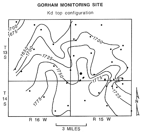
The Gorham monitoring site is located in western Russell County along the crest of the north-plunging Fairport-Natoma Anticline. Figure 34 is a map showing the configuration of the top of the Dakota in the vicinity of the monitoring site. The map shows that in vicinity of the monitoring site the near-surface rocks are essentially flat lying. East and west of the site the rocks in the near surface dip away from the crest of the Fairport-Natoma anticline at 30 to 40 feet per mile. Unconsolidated surficial deposits of Pleistocene age mantle the site area and are underlain by the Upper Cretaceous Greenhorn Limestone. Dakota Formation outcrops are approximately five miles north and south of this monitoring site.
Figure 34. Configuration of the top of the Dakota Formation in the vicinity of the Gorham multiple-completion monitoring well.
7.2.2 Arrangement of the Piezometers
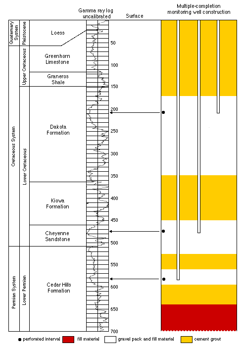
The multiple-completion well at the site consists of three 1.5-in. OD standpipe piezometers placed in a borehole cased with 5.5-in. OD steel casing. Three ten-foot sections were perforated for the monitoring well in the following intervals (measured in feet below the top of the steel casing): 200-210, 470-480, and 575-585. A ten-foot section of screen is located at the bottom of each piezometer to allow monitoring of the upper part and lower parts of the Great Plains aquifer (upper Dakota Formation and Cheyenne Sandstone, respectively), and the Cedar Hills aquifer. The construction is shown schematically in Figure 35. Construction of the monitoring site began on March 9 and was completed by March 20, 1987.
Figure 35. Construction and location of monitored zones, Gorham multiple-completion monitoring well-site.
7.2.3 Hydrologic Conditions
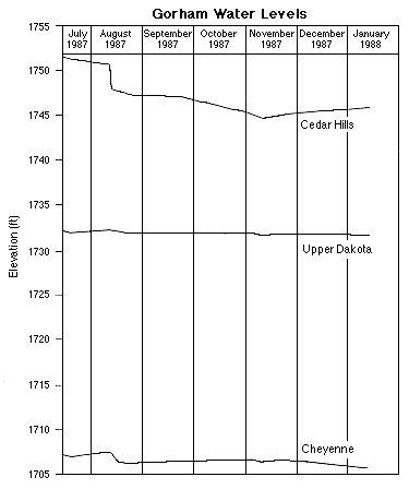
Shallow ground waters occur near the base of the Pleistocene loess in residual gravels and weathered bedrock. West of the monitoring site, these gravels contain sufficient ground water to supply the town of Gorham. The thickness of the unconsolidated materials at the site is approximately 22 ft. Figure 36 shows the hydrographs (record of water levels) for the piezometers at the monitoring site from mid-July, 1987, to mid-January, 1988. Overall, the hydraulic head in the upper part of the Great Plains aquifer (upper Dakota) is higher than in the lower part (Cheyenne). However, the hydraulic head in the Cedar Hills aquifer is considerably higher than hydraulic head in the Great Plains aquifer. This suggests that the intermediate portions of the Great Plains aquifer (lower part of the Dakota Formation) may be receiving recharge from shallower and deeper zones and that a water-quality transition between fresh and saline waters may be present in this portion of the aquifer. This is discussed further in section 7.2.4.
Figure 36. Hydrographs of the piezometers, Gorham multiple-completion monitoring well.
Some perspective on the nature of the flow system in the Great Plains and Cedar Hills aquifers can be gained by examining the rate of increase of fluid pressure with depth at the Gorham monitoring site. Figure 37 shows a plot of these fluid pressures at the corresponding depth of measurement below land surface. For locations intermediate between regional recharge and discharge areas, the rate of increase of fluid pressure with depth should approximate the rate of increase of hydrostatic pressure (Toth, 1979). In recharge and discharge areas, the rate of fluid pressure increase with depth will be less than or greater than the rate of hydrostatic pressure increase, respectively. At the Gorham site, relatively low fluid pressures in the upper and lower portions of the Great Plains and Cedar Hills aquifers indicate subpressuring of these aquifers.
Figure 37. Profile of fluid pressure versus depth, Gorham multiple-completion monitoring well.
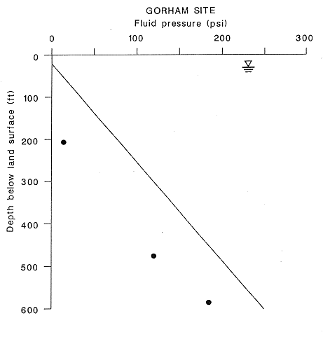
These low fluid pressures suggest that the Great Plains and Cedar Hills aquifers are relatively isolated from the near surface hydrologic system. A fairly typical example of an underpressured aquifer system is the Great Plains aquifer in the Denver Basin. Russell (1972) reports fluid pressure-depth ratios of 0.23 and 0.261 psi/ft for sandstones belonging to the Dakota Formation in the Denver Basin in Colorado and Nebraska, respectively. Fluid pressure-depth ratios at the Gorham site increase from 0.08 psi/ft. for the upper part of the Great Plains aquifer to 0.32 psi/ft. for the Cedar Hills aquifer. The hydrostatic pressure increase with depth is 0.43 psi/ft. This situation is problematic since the Dakota Formation outcrop is less than five miles away from the monitoring site and is believed to be a discharge zone for the Great Plains aquifer (Figures 17 and 18). Viewed in this light, the apparent underpressuring may be caused by relatively greater isolation of these aquifers from recharge sources than points of discharge even though the aquifer is only 200 feet below land surface.
7.2.4 Ground-Water Geochemistry
Waters collected from all three zones of the well are of sodium-chloride type. Calcium and magnesium concentrations in the sample from the Upper Dakota aquifer are very low in comparison with the dissolved sodium content. The values suggest that cation exchange has affected the water chemistry. However, the field pH of the sample was higher (9.15) than that expected (near 7) for the aquifer. The high pH could indicate leaching of cement in the well. The pH could have decreased calcium and magnesium concentrations by precipitating calcium carbonate containing some magnesium. The bicarbonate concentrations are also somewhat lower than expected if cation exchange with concomitant carbonate solution had occurred. Future well development should provide water samples with lower pH that will allow more conclusive examination of cation exchange and carbonate equilibria relationships for the Upper Dakota. However, the high pH should not appreciably affect the relationships of the anionic and neutral species and the sodium concentration in the sample. Thus, the relatively high Na/Cl ratio suggests that cation exchange may have been important in the origin of the present water chemistry.
The Cheyenne and Cedar Hills waters contain relatively high calcium and magnesium concentrations, low to moderate bicarbonate contents, and Na/Cl ratios below 0.62, indicating that cation exchange does not appear to have had a substantial effect on the present water chemistry. The ratios of major constituents in the waters from the two aquifers are similar to those for oil-field brines in the local area surrounding the site (Kansas Geological Survey, 1973). Swineford and Williams (1945) also determined that the introduction of oil-field brines had affected the chemistry of some of the waters in the Dakota Formation in Russell County.
Conclusive evidence based on Br/Cl ratios and mixing curves indicates that appreciable amounts of oil-field brines disposed into the Cedar Hills Sandstone and possibly the Cheyenne Sandstone can be detected in the aquifers away from the injection sites. The points for both the Cedar Hills and Cheyenne water samples plot within the mixing zone of freshwaters and oil brines on Figure 29, while the point for the sample from the Upper Dakota aquifer plots in the middle of the mixing zone between freshwater and halite-solution brine. Thus, the oil-field brine does not appear to have migrated to the Upper Dakota strata at this site.
Saline seepage from the Great Plains aquifer into Salt Creek several miles to the northeast of the monitoring site has earlier been identified as being predominatly derived from a halite-brine source (Whittemore and Pollock, 1979). The salinity identification for the seepage and the Upper Dakota water at the Gorham site indicate that uncontaminated saline water in the Great Plains aquifer in west-central Russell County has a different chemistry from that found in the Cedar Hills and Cheyenne samples at the monitoring site.
The Br/Cl and Na/Cl ratios for the water from the Cedar Hills strata are higher and lower, respectively, than those for the Cheyenne Sandstone. The first interpretation is that more oil brine is mixed with the original ground water in the Cedar Hills aquifer than in the Cheyenne aquifer. An explanation could be that oil brine injected into the Cedar Hills Sandstone has migrated upward into the Cheyenne strata. Mixing curves of Br/Cl versus chloride concentration drawn from a probable oil-brine endpoint through the points for the present waters from the two aquifers to the middle of the freshwater and halite-brine mixing zone could be used to estimate the chloride content of the original, uncontaminated water in the aquifers.
If a single type of oil-field brine with a chloride concentration higher than that present in the two aquifer waters is used as an endpoint, the extrapolation would give a chloride content of original water in the Cedar Hills aquifer substantially less than that in the Cheyenne aquifer. This would be an unexpected result. Alternatively, if the chloride contents of uncontaminated waters in the two aquifers were nearly the same or higher in the Cedar Hills than in the Cheyenne Sandstone, the oil brine sources would have been different. Either different oil brines could have been injected into the Cedar Hills at the beginning than the latter period of the disposal history, or different oil brines were injected into both the Cedar Hills and Cheyenne strata.
The location of the oil-brine samples on both the oxygen-deuterium and sulfur isotope graphs (Figures 32 and 33) indicates that brines similar to these are not the source of contamination of the ground waters sampled at the monitoring site. Isotope fingerprinting of petroleum brines suggests that samples from the same field or pool withdrawing oil from the same geologic horizon will be similar, whereas samples from different geologic horizons or different fields but from the same horizon may vary significantly (Thode and Monster, 1965). The samples collected in this study were from different fields although from the same geologic units. The lack of stable isotope and 34S correlation between the brines and water at the Gorham site is most likely due to not having samples from the production wells that produced the brine that was disposed in the Gorham area. Brines will be sampled at production wells that historically have supplied saltwaters to nearby Cedar Hills disposal wells.
Previous page--Monitoring Wells ||
Next page--Hill City Monitoring Site
Start of Report ||
Report Contents