Optical-fiber temperature logging, part 3 of 4
Figure 1. Plots of temperature and geothermal gradient versus depth as obtained by the different logging devices in two boreholes. DTS data are in red, conventional log is in blue. Data are plotted at 1 m intervals with gradients smoothed by 2 m running average: A, Smokyhill borehole; B, Big Springs borehole. Major stratigraphic units and their lithology (lithologic symbols standard) are shown. A larger version of this figure is also available.
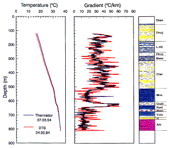
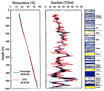
In addition to the temperature data, the thermal gradients computed on the basis of 1-m logging intervals are plotted versus depth and compared to lithology (Fig. 1A and 1B). To exclude erratic temperature gradient values both data sets are smoothed using a 2-m running average. As can be seen in the plots, there is little difference in the large-scale gradients from conventional and DTS data. The major difference appears to be an oscillation in the DTS temperatures. Other differences are because the DTS gradients are the integrated signal for the 1-m logging interval compared to the single reading obtained by the conventional technique. Despite the differences in the gradient plots, both the conventional gradients and the DTS gradients show good response to the alternating lithologic (stratigraphic) units of different thermal conductivity, for example the change between the lower Paleozoic carbonates and the upper Paleozoic clastic sequence at 520 m in the Big Springs well (Fig. 1B). Thin interbedded shale units, for example the Chattanooga Shale (at 630 m), can be identified by the DTS gradient pattern. However, it also is obvious that the DTS gradient graph differs slightly in amplitude locally compared to the corresponding high-resolution values. Despite the differences in detail, the overall pattern matches the stratigraphic sequence and lithologies well.
In the Smokyhill borehole the absolute difference in gradients in most units is small (the maximum difference is 2.4 degrees C/km) with a depth-weighted mean gradient difference of 0.08 degrees C/km. The relative gradient errors range only from about 1 to 6% (Fig. 2A). Gradient differences are observed for all formations regardless of their lithologic make up. In the Big Springs borehole the absolute gradient difference for most of the units is between 1 and 3.5 degrees C/km with a relative gradient error in the range of 1 to 11% (Fig. 2B). The largest difference is about 11 degrees C/km (about 100%) for the Simpson Group, however, the depth interval involved is only 14 m. In both examples, the average gradient is consistently somewhat higher for the DTS log even after the improvement in calibration in 1995. Some improvement in temperature calibration of the DTS system still needs to be made for an exact absolute comparison to conventional logging systems.
Figure 2. Difference of formation gradients for two logs. A, Smokyhlll borehole, B, Big Springs borehole. Gradients calculated on basis of 1 m intervals and smoothed by 2 m running average.
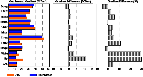
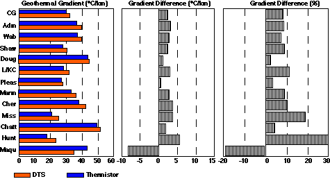
Figure 3. Difference of interval gradients resulting from comparison of two sets of unsmoothed logging data obtained in Smokyhill borehole: A, gradient interval 1 m; B, gradient interval 2 m; C, gradient interval 5 m; D, gradient interval 10 m. A larger version of this figure is also available.
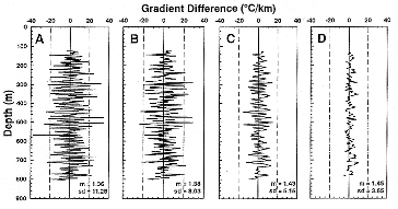
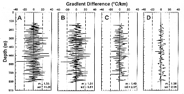
Figure 4. Gradient difference obtained at 1 m intervals in Smokyhlll borehole in comparison to gradient differences smoothed by different running averages: A, unsmoothed; B, smoothed by 2 m running average; C, smoothed by 5 m running average; D, smoothed by 10 m running average. A larger version of this figure is also available.
Previous page--Sites ||
Next page--Discussion
Dakota Home ||
Start of Hydrology Section