![]()
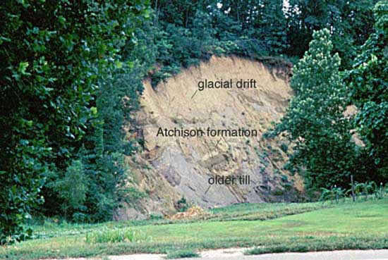
Fig. 6. Exposure of the Atchison Formation along White Clay Creek west of Atchison (SE NW sec. 10, T. 6 S., R. 20 E.). The older till and Atchison formation were deformed by the later glacial event that deposited the glacial drift. At this location, the drift is a younger till. For more information on this outcrop, see Aber (1991).
The Atchison formation is alluvium comprising tan to gray sand and gravel (table 1, fig. 6); it ranges in thickness from 0 to 24.3 m (0 to 80 ft). The unit is below the glacial drift and rests unconformably on bedrock and the older glacial till. Exposures of the Atchison formation occur mainly along White Clay Creek.
The glacial drift rests unconformably on top of Pennsylvanian bedrock and the Atchison formation throughout the study area. Glacial drift dominates the western portion of the study area and can be found on most hilltops in the east (fig. 3). Drift includes glacial till, outwash, and lakebeds. The tills are gray to reddish-brown, poorly sorted, ice-transported sediments. Boulder-sized fragments were observed in fields in the drift area. The outwash deposits are tan to brown, sandy to gravelly alluvium. The "Nortonville Clay" (Frye and Leonard, 1952) was mapped with the glacial drift. The "Nortonville Clay" is gray clay with some silt that was deposited above the till. Frye and Leonard (1952) proposed that this unit was deposited in ice-marginal lakes and lakes in depressions on the till surface.
Aber (1991) combined the older unmapped till, the Atchison formation, and the glacial drift into one unit. This unit, called the Independence formation, represents two pre-Illionoian glacial advances.
Loess can be found along hilltops in various locations throughout the study area (fig. 3). The loess is gray, clayey silt, with a little sand; it weathers yellow brown to brown (table 1) and ranges in thickness from 0 to 12.2 m (0 to 40 ft).
Quaternary alluvium can be found along the Missouri River and its tributaries (fig. 3). It is composed of channel sand and gravel and floodplain silt (table 1). The thickness of the Quaternary alluvium ranges from 0 to 32.0 m (0 to 105 ft) (Ward, 1973).
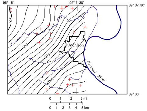
Fig. 7. Structural contour map of the study area on the base of the Deer Creek Limestone. Red crosses represent the data points used to generate contours. Additional data points outside the study area were used and are not shown in the figure. There are no outcrops of the Deer Creek Limestone east of Atchison, and a pre-glacial river channel removed the Deer Creek Limestone due west of Atchison (Dreeszen and Burchett, 1971).
Kansas Geological Survey
Web version December 22, 2000
http://www.kgs.ku.edu/Current/2000/ohlmacher/ohlmacher4.html
email:lbrosius@kgs.ku.edu