![]()
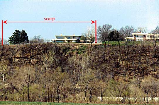
Fig. 8. A recent landslide along Riverview Drive south of downtown Atchison (SW NE sec. 7, T. 6 S., R. 21 E.). The scarp (the surface break at the top of the landslide) is along the road at the top of the hill, and the toe (where material piles up at the bottom of the landslide) is at the base of the slope. The houses in the photograph are set back from the top of the hill and are not currently involved in the landslide.
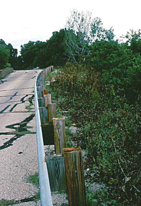
Fig. 9. Scarp of the recent landslide along Riverview Drive (see fig. 8). The landslide has removed one lane from the street.
This report uses the landslide classification developed for the Transportation Research Board (Cruden and Varnes, 1996; Varnes, 1978), which subdivides landslides into material type and movement type. The material types are rock, debris, and earth. Rock is any material that requires blasting or splitting prior to removal; in the study area, rock consists primarily of layers of limestone. Debris is soil in which the average grains are sand-sized or larger, and earth is soil in which the average grain size is silt and smaller.
Four types of movement are found in the study area--falls, topples, flows, and slides. Falls occur where blocks of rock or soil break free and drop vertically before hitting the ground surface (fig. 10a). Topples occur where blocks of rock or soil rotate or pivot about an axis at the base of the block (fig. 10b). Both falls and topples are common in areas where layers of limestone overlay shales and siltstones (fig. 4). The shales and siltstones erode from beneath the limestones leaving unsupported blocks. Slides occur where a mass of soil or rock moves along a planar surface at the base of the landslide (fig. 10c). The material within the landslide mass may rotate but remains relatively intact during failure. Flows (fig. 11) occur where a mass of soil moves above a planar surface; however, the movement is distributed throughout the landslide mass approaching a fluidlike motion (fig. 10d). Earth slides, earth flows, and combinations of the two types are common throughout the study area.
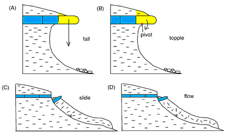
Fig. 10. Different types of landslide movement. (A) Falls occur where a block of material free-falls from a slope. (B) Topples involve rotation of a block of material along an axis at the base of the block. (C) Slides occur where a relatively intact mass of material moves along a basal failure plane. (D) Flows occur where motion is distributed throughout the landslide mass approaching fluid-like behavior.
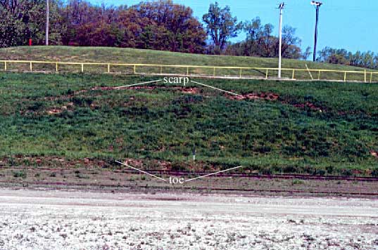
Fig. 11. An earth flow at the U.S. Army underground storage facility in the south end of Atchison, Kansas (SW SE sec. 7, T. 6 S., R. 21 E.).
A landslide inventory map was prepared for the study area (Ohlmacher, 2000). This map depicts recent landslides, older landslides, and rock-fall hazards. Recent landslides are earth slides and earth flows with distinct features and clearly defined boundaries. These landslides include active landslides that had moved within a year of the study, along with suspended and dormant landslides that still had recognizable ground breaks. Older landslides had hummocky topography that indicated past landslide movement, but they lacked fresh surface breaks and clearly defined boundaries. Older landslides include dormant, relic, and ancient earth slides and earth flows as defined by Cruden and Varnes (1996).
Rock-fall hazards are nearly vertical exposures of rock where the potential for rock falls and rock topples is high. Rock-fall hazards occur in quarries (fig. 4), in highway cuts, along the bluffs of the Missouri River and its tributaries, and where streams have eroded into the base of hills exposing bedrock. It should be noted that some of the newer highway cuts made by the Kansas Department of Transportation are designed to minimize rock-fall hazards (fig. 5). Individual rock falls were not mapped as part of the project.
Kansas Geological Survey
Web version December 22, 2000
http://www.kgs.ku.edu/Current/2000/ohlmacher/ohlmacher5.html
email:lbrosius@kgs.ku.edu