Kansas Geological Survey, Current Research in Earth Sciences, Bulletin 244,
part 3
The Relationship Between Geology and Landslide Hazards of Atchison, Kansas, and Vicinity--Fig. 7
![]()
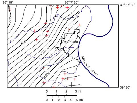
Fig. 7. Structural contour map of the study area on the base of the Deer Creek Limestone. Red crosses represent the data points used to generate contours. Additional data points outside the study area were used and are not shown in the figure. There are no outcrops of the Deer Creek Limestone east of Atchison, and a pre-glacial river channel removed the Deer Creek Limestone due west of Atchison (Dreeszen and Burchett, 1971).