![]()
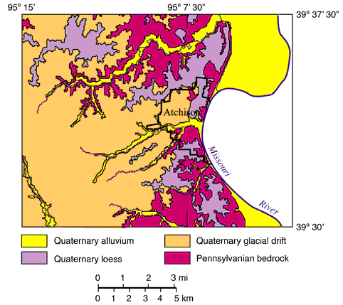
Fig. 3. Generalized geologic map of the study area (from Ohlmacher, 1999).
Table 1. Description of the geologic units, based on data from Price (1896), Condra (1927), Ward (1973), R. C. Moore (unpublished data), and author's field notes.
| Age | Geologic unit | Thickness m (ft) |
Description |
|---|---|---|---|
| Quaternary | alluvium | 0-32 (0-105) | Tan, brown, and gray silt, sand, and gravel |
| loess | 0-12.2 (0-40) | Gray, clayey, sandy silt that weathers yellow to brown | |
| glacial drift | highly variable | This unit includes glacial till (gray, poorly sorted clay to boulders that weather brown), outwash deposits (tan to brown sand and gravel), and the "Nortonville clay" (gray to brown silty clays) | |
| Atchison formation | 0-24.3 (0-80) | Tan to gray, silty sand to gravel | |
| Pennsylvanian | Topeka Limestone Hartford Limestone Member |
1.2 (3.8) | Gray, massive limestone that weathers yellow-brown |
| Calhoun Shale | 5.2 (17) | Gray, bluish- to greenish-gray, blocky to flaggy, interbedded siltstone and shale that weathers yellow-brown | |
| Deer Creek Limestone Ervine Creek Limestone Member |
5.2 (17) | Gray to tan, wavy-bedded to massive limestone that weathers yellow-brown | |
| Deer Creek Limestone Larsh-Burroak Shale Member |
1.5 (4.8) | Gray siltstone and shale, overlying black shale, siltstone, and coal | |
| Deer Creek Limestone Rock Bluff Limestone Member |
0.6 (1.9) | Light- to medium-gray, massive limestone that weathers yellow- brown | |
| Deer Creek Limestone Oskaloosa Shale Member |
2.3 (7.6) | Gray siltstone and shale with gray sandstone layers | |
| Deer Creek Limestone Ozawkie Limestone Member |
0.9 (3) | Gray, massive limestone that weathers yellow-brown | |
| Tecumseh Shale | 19.8 (65) | Gray to green-gray, interbedded shale and siltstone with yellow to tan sandstone | |
| Lecompton Limestone Avoca Limestone Member |
0.4 (1.2) | Dark blue-gray limestone that weathers yellow-brown | |
| Lecompton Limestone King Hill Shale Member |
1.9 (6.2) | Bluish-gray silty shale | |
| Lecompton Limestone Beil Limestone Member |
1.6 (5.2) | Gray, shaly limestone that weathers yellow-brown | |
| Lecompton Limestone Queen Hill Shale Member |
1.5 (4.8) | Blue-gray, silty shale overlying black, fissile shale | |
| Lecompton Limestone Member Big Springs Limestone |
0.8 (2.6) | Gray to tan, massive limestone that weathers yellow-brown | |
| Lecompton Limestone Doniphan Shale Member |
1.9 (6.1) | Bluish-gray, bedded, silty to calcareous shale that weathers yellow-brown | |
| Lecompton Limestone Spring Branch Limestone Member |
1.4 (4.7) | Two, gray to tan, massive limestone layers that weather yellow-brown, separated by a thin (15-cm), gray to tan shale; the shale may be absent | |
| Kanwaka Shale Stull Shale Member |
11.1 (36.4) | Gray, bluish-gray to greenish-gray siltstone and shale and tan to gray sandstone; a discontinuous coal or black shale may exist above the sandstone; in some areas, the base is 20-cm (8-in) clay | |
| Kanwaka Shale Clay Creek Limestone Member |
0.8 (2.7) | Gray, massive limestone that weathers yellow-brown; the top may be marked by a red, thin, shaly limestone | |
| Kanwaka Shale Jackson Park Shale Member |
1.9 (6.1) | Gray, bluish-gray to green-gray, thinly bedded siltstone and shale with some sandstone layers; the unit weathers tan to brown | |
| Oread Limestone Kereford Limestone Member |
0.8 (2.6) | Gray limestone; thin or absent in parts of the study area | |
| Oread Limestone Heumader Shale Member |
1.4 (4.7) | Gray to greenish-gray shale and silty shale that weathers brown | |
| Oread Limestone Plattsmouth Limestone Member |
6.2 (20.5) | Medium- to dark-gray, wavy-bedded limestone that weathers light-gray to light yellow-brown | |
| Oread Limestone Heebner Shale Member |
1.4 (4.5) | Dark-gray, fissile to platy shale and silty shale, overlying black fissile to platy shale | |
| Oread Limestone Leavenworth Limestone Member |
0.5 (1.7) | Dark-gray, massive limestone | |
| Oread Limestone Snyderville Shale Member |
3.8 (12.5) | Gray shale and silty shale | |
| Oread Limestone Toronto Limestone Member |
2.3 (7.5) | Light-gray to yellow-gray, massive limestone that weathers yellow- brown | |
| Lawrence Formation | 7.6+ (25+) | Green-gray shale, red beds, and coal |
The following descriptions of the geologic units are based on published reports (Price, 1896; Condra, 1927; and Ward, 1973). Additional data came from measured sections by R. C. Moore (unpublished data) and the author.
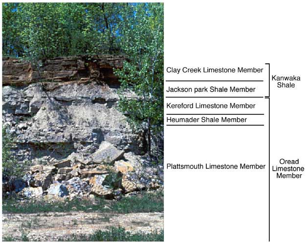
Fig. 4. Upper part of the Oread Limestone and the lower part of the Kanwaka Shale, exposed in a quarry in the SW SW sec. 21, T. 6 S., R. 21 E.
The Kanwaka Shale forms a gentle slope between the Oread Limestone and the overlying Lecompton Limestone in the central and eastern portions of the study area. The Kanwaka Shale is approximately 17.8 m (58.4 ft) thick and is composed of two gray shale and siltstone members separated by the Clay Creek Limestone Member (table 1). The Stull Shale Member, the upper shale and siltstone member, contains sandstone and a discontinuous coal layer. Exposures of the Kanwaka Shale are limited to highway outcrops (fig. 5) and areas where streams are eroding the base of the hills.
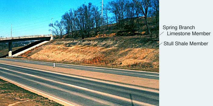
Fig. 5. The Stull Shale Member of the Kanwaka Shale and the Spring Branch Limestone Member of the Lecompton Limestone, exposed in a roadcut along US-73 south of Atchison (SW SE sec. 1, T. 6 S., R. 20 E.)
The Lecompton Limestone is not well exposed in the study area. However, individual limestone layers are observed in many locations. The Lecompton Limestone forms a steep slope above the Kanwaka Shale. Ward (1973) stated that the Lecompton Limestone in Atchison County is from 10.7 to 13.7 m (35 to 45 ft) thick. The formation is composed of four limestone members separated by gray calcareous shales and siltstone (table 1). A black shale layer overlies the Big Springs Limestone Member. The basal Spring Branch Limestone Member can be seen below the trees in figure 5.
The Tecumseh Shale forms a gentle slope between the Lecompton Limestone and the overlying Deer Creek Limestone in the central portion of the study area. The Tecumseh Shale is approximately 19.8 m (65 ft) thick and consists of gray shale and siltstone and yellow to tan sandstone layers (table 1). Several exposures of the Tecumseh Shale can be found along US-73 in the southern portion of the study area.
The Deer Creek Limestone forms a steep slope on the hillsides between the Tecumseh and Calhoun shales in the central portion of the study area. The formation is 10.5 m (34.3 ft) thick and is composed of gray to bluish-gray limestone, gray shale and siltstone, black shale, sandstone, and minor amounts of coal (table 1). The thickest limestone is the Ervine Creek Limestone Member, which is 5.2 m (17.0 ft) thick. The Ervine Creek Member is quarried for aggregate and industrial uses.
The Calhoun Shale overlies the Deer Creek Limestone and is below the Topeka Limestone. The Calhoun Shale is only exposed in a few areas in the northwest portion of the study area. The Calhoun Shale is approximately 5.2 m (17.0 ft) thick and consists of alternating thin (centimeters-thick) layers of gray shale and gray to tan siltstone and sandstone (table 1).
The basal Hartford Limestone Member of the Topeka Limestone is the uppermost bedrock unit exposed in the study area. The Hartford is a gray, massive limestone that is approximately 1.2 m (3.8 ft) thick (table 1). Other members of the Topeka Limestone exist below the glacial drift in the western part of the study area.
Kansas Geological Survey
Web version December 22, 2000
http://www.kgs.ku.edu/Current/2000/ohlmacher/ohlmacher3.html
email:lbrosius@kgs.ku.edu