Kansas Geological Survey, Current Research in Earth Sciences, Bulletin 241, part 3
Prev Page--GPR Data Acquisition and Processing || Next Page--Captain Creek Limestone Member, cont.
![]()
![]()
![]()
Kansas Geological Survey, Current Research in Earth Sciences, Bulletin 241, part 3
Prev Page--GPR Data Acquisition and Processing ||
Next Page--Captain Creek Limestone Member, cont.
![]()
The Captain Creek study site (fig. 2) is located in northwestern Johnson County, Kansas (SQE-1 of Cunningham and Franseen, 1992). [Note: Recent studies and observations by one of the authors (Franseen) bring to question whether the strata at this study site belong to the Captain Creek Limestone and the Vilas Shale. However, these designations will be adhered to in this report as they have no bearing on the results of the outcrop and GPR study.] Two 106-m (348-ft) profiles of GPR data were collected to image features associated with the Captain Creek Limestone Member of the Stanton Limestone (within the Stanton depositional sequence of Watney et al., 1989) and the underlying Vilas Shale (which caps the subjacent Plattsburg depositional sequence of Watney et al., 1989) (fig. 3). The site was chosen to determine the capabilities of GPR to image (1) the erosional contact between the Captain Creek and Vilas Shale; (2) the contact between the lower and upper Captain Creek submembers; and (3) internal bedding geometries and truncations in the lower and upper Captain Creek submembers.
Fig. 2--Map of eastern Kansas showing the locations of the outcrops used for this study.
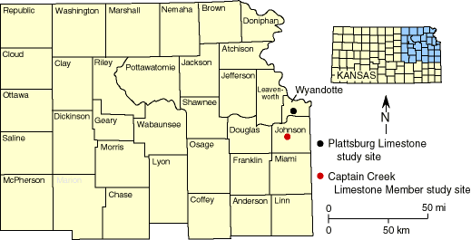
Fig. 3--Stratigraphic column of Upper Pennsylvanian stata in northeastern Kansas. The two units used for this study, the Captain Creek Limestone Member and the Plattsburg Limestone, are highlighted.

The Vilas Shale is a gray mudstone, silty or sandy shale, or fine-grained sandstone containing mica and carbonized plant fragments (Cunningham and Franseen, 1992). It represents deltaic sedimentation during a relative lowstand in base level, and the upper surface is considered the sequence boundary of the Plattsburg depositional sequence (Watney et al., 1989).
The Captain Creek is the flooding unit within the Stanton depositional sequence and represents initial carbonate sedimentation during a relative rise in sea level (Watney et al., 1989). Cunningham and Franseen (1992) proposed two submembers for the Captain Creek Member. The lower submember is a gray or brown, conglomeratic lime grainstone composed of small, pebble-sized limestone clasts, bioclasts, and shale clasts and locally containing 0.1-0.3-m (0.3-0.9-ft)-scale horizontal bedding and local foresets. The upper Captain Creek submember is more massively bedded and typically occurs as a gray to light-brown phylloid, brachiopod, crinoid, and bryozoan lime wackestone-packstone.
The contact of the lower Captain Creek conglomeratic submember with the Vilas Shale indicates some erosional modification and is interpreted as a sequence boundary resulting from a relative sea-level fall. According to Cunningham and Franseen (1992), the Captain Creek conglomerates were deposited as tidal channel-fills in bathymetrically constricted areas between the Bonner Springs and Olathe algal mounds during a relative sea-level rise.
Prev Page--GPR Data Acquisition and Processing || Next Page--Captain Creek Limestone Member, cont.
Kansas Geological Survey
Web version September 15 1998
http://www.kgs.ku.edu/Current/1998/martinez/martinez4.html
Comments to webadmin@kgs.ku.edu