Kansas Geological Survey, Current Research in Earth Sciences, Bulletin 240, part 4
Next page—Appendices
![]()
![]()
Kansas Geological Survey, Current Research in Earth Sciences, Bulletin 240, part 4
Next page—Appendices
![]()
1Kansas Geological Survey
2U.S. Geological Survey, Denver Federal Center
Summary and citation information available for this article. The complete article is available as an Acrobat PDF file (600 kB).
Elemental and chemical analyses and physical tests were conducted on 36 samples of Middle and Upper Pennsylvanian coals from southeastern Kansas. Concentrations of 35 minor and trace elements in these coals were statistically compared with concentrations in coals of similar rank and age from other areas in the western region of the Interior Coal Province, showing that Kansas coals have significantly higher concentrations of copper, arsenic, and lead. The zinc content in Kansas coal samples ranges from 160 to 51,000 ppm (whole-coal basis), the maximum value being the highest zinc value reported for U.S. coals. Cadmium content also has an extreme range, from less than 1.0 to 160 ppm (whole-coal basis), the maximum value being one of the highest cadmium values reported in U.S. coals. The apparent ranks of these coal samples range from high-volatile B to high-volatile A bituminous coal. Most samples of Middle Pennsylvanian coals from the major coal-mining area in Bourbon, Crawford, and Cherokee counties are high-volatile A bituminous coal. Arithmetic mean values for proximate analyses of coals (as-received basis; n = 25) show these coals to be 15.5% ash, 35.3% volatile matter, 45.9% fixed carbon, and 3.3% moisture and to have a heat of combustion of 11,910 Btu/lb. Arithmetic mean values for ultimate analyses of the coals show these coals to be 4.9% hydrogen, 65.3% carbon, 1.2% nitrogen, 5.5% sulfur, and 7.7% oxygen. The geometric mean values of these Kansas coals are 3.03% pyritic sulfur, 1.25% organic sulfur, and 0.2% sulfate sulfur.
Kansas coal has been an important contributor to the heat and power generation required by the developing Kansas economy. Commercial production of coal in Kansas started in the 1850's with the first shallow mines near Fort Leavenworth in Leavenworth County (Schoewe, 1958, p. 369-371). Subsequent development of coal mines in eastern Kansas has resulted in total historic bituminous coal production of slightly over 300 million tons through 1996. Most of this production was from the Weir-Pittsburg coal bed that was deep-mined in Cherokee and Crawford counties. Kansas coal production was highest in 1917 and 1918 when approximately 7.25 million tons were produced annually. Since those early days, coal production has declined to a low of 232 thousand tons in 1996 (based on production figures from the Mining Section, Kansas Department of Health and Environment). Kansas coal production reached 2.02 million tons in 1987 for a recent high, but production declines since that time are due mainly to recent Environmental Protection Agency standards for SO2 emissions and the subsequent import of Wyoming coal into Kansas.
The U.S. Geological Survey, with cooperation from state governments and industry, has made characterization of the chemical composition of coal a significant part of the assessment of the nation's coal resources. The Kansas Geological Survey contributed to this program by collecting 36 samples of Middle and Upper Pennsylvanian coals between 1974 and 1977 from Franklin, Wilson, Bourbon, Crawford, and Cherokee counties. These samples are representative of nine Kansas coal beds that are presently mined or were mined in the recent past (table 1). Thirty-one of these samples were collected from active mines, one from a construction excavation, and four samples are from mine tipples after coal cleaning. The information from the chemical and physical tests helps to characterize the most important coal beds with significant reserves remaining in the state.
Table 1—Location and identification of coal samples.
| Sample no. |
County | Location | Bed | Bed thickness (inches) |
Sample type |
|---|---|---|---|---|---|
| D176058 | Franklin | NW sec 30, T18S, R18E | U. Williamsburg | 12 | Grab (5 in. thick) |
| D176055 | Wilson | SW sec 21, T29S, R17E | Thayer | 10 | Channel (upper bed) |
| D176056 | Wilson | SW sec 21, T29S, R17E | Thayer | 11 | Channel (upper bed) |
| D176057 | Wilson | SW sec 21, T29S, R17E | Thayer | 5 | Channel (lower bed) |
| D189091 | Bourbon | SE sec 26, T26S, R25E | Mulky | 14 | Channel (lower bed) |
| D189704 | Bourbon | SE sec 26, T26S, R25E | Mulky | 14 | Channel (lower bed) |
| D189705 | Bourbon | SE sec 26, T26S, R25E | Mulky | 14 | Channel (lower bed) |
| D196196 | Bourbon | NW sec 28, T26S, R25E | Mulky | 14 | Channel (lower bed) |
| D196197 | Bourbon | NW sec 28, T26S, R25E | Mulky | 13 | Channel (lower bed) |
| D196198 | Crawford | SE sec 2, T31S, R22E | Bevier | 18 | Channel (lower bed) |
| D196199 | Crawford | SE sec 2, T31S, R22E | Bevier | 13 | Channel (lower bed) |
| D183114 | Bourbon | SW sec 25, T26S, R25E | Croweburg | 14 | Channel (lower bed) |
| D183115 | Crawford | NE sec 16, T28S, R25E | Croweburg | 14 | Channel (lower bed) |
| D176045 | Crawford | SW sec 5, T28S, R25E | Croweburg | 12 | Channel (lower bed) |
| D176046 | Crawford | SW sec 5, T28S, R25E | Croweburg | 13 | Channel (lower bed) |
| D176047 | Crawford | SW sec 5, T28S, R25E | Croweburg | 11 | Channel (lower bed) |
| D183120 | Crawford | NE sec 16, T28S, R25E | Croweburg | -- | Tipple |
| D183112 | Bourbon | SW sec 25, T26S, R25E | Mineral | 16 | Channel |
| D183113 | Bourbon | SW sec 25, T26S, R25E | Mineral | 15 | Channel |
| D176048 | Crawford | NW sec 15, T28S, R25E | Mineral | 17 | Channel |
| D176049 | Crawford | NW sec 15, T28S, R25E | Mineral | 17 | Channel |
| D183116 | Crawford | NE sec 16, T28S, R25E | Mineral | 16 | Channel |
| D183119 | Crawford | NE sec 16, T28S, R25E | Mineral | -- | Tipple |
| D180072 | Crawford | SE sec 10, T31S, R25E | Dry Wood | 12 | Channel |
| D180074 | Crawford | SW sec 11, T31S, R25E | Dry Wood | 12 | Channel |
| D183118 | Crawford | sec 10-11, T31S, R25E | Dry Wood | -- | Tipple |
| D176050 | Crawford | NE sec 10, T31S, R25E | Rowe | 18 | Channel |
| D176051 | Crawford | NE sec 10, T31S, R25E | Rowe | 18 | Channel |
| D176052 | Crawford | NE sec 10, T31S, R25E | Rowe | 20 | Channel |
| D180069 | Crawford | SE sec 10, T31S, R25E | Rowe | 18 | Channel |
| D180071 | Crawford | SE sec 10, T31S, R25E | Rowe | 17 | Channel |
| D180073 | Crawford | SE sec 11, T31S, R25E | Rowe | 16 | Channel |
| D183117 | Crawford | sec 10-11, T31S, R25E | Rowe | -- | Tipple |
| D189706 | Cherokee | NW sec 18, T32S, R25E | Rowe | 12 | Channel |
| D176053 | Cherokee | NW sec 20, T32S, R25E | Unnamed | 14 | Channel |
| D176054 | Cherokee | NW sec 20, T32S, R25E | Unnamed | 14 | Channel |
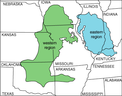
A generalized stratigraphic distribution of the bituminous coals in Kansas is shown in fig. 1, whereas areal distribution of the strippable Pennsylvanian coals by group is shown in fig. 2. The general distribution of Pennsylvanian coal in Kansas relative to the coal areas of the western and the eastern regions of the Interior Coal Province is shown in fig. 3. Coal from the Middle Pennsylvanian (Desmoinesian) Cherokee Group (including the nine coals sampled for this study plus the Weir-Pittsburg and Fleming coals) represents 90% of the historical production in Kansas. Stratigraphic descriptions of the important coal beds in the Cherokee Group are to be found in Pierce and Courtier (1938), Howe (1956), and Brady et al. (1976). Past production from the Middle Pennsylvanian (Desmoinesian) Marmaton Group (Mulberry coal) represents about 5% of the state's production, and coals in the Upper Pennsylvanian (Virgilian) Wabaunsee Group (mainly the Nodaway coal) account for nearly 4%. Production from the Upper Pennsylvanian (Missourian) Kansas City Group (mainly Thayer coal), the Upper Pennsylvanian (Virgilian) Douglas Group (mainly Williamsburg coals), and the Early Cretaceous lignites of the Dakota Formation together represent less than 1% of cumulative Kansas coal production.
Figure 1—Stratigraphic position of coal beds discussed in this report (column modified from Zeller, 1968).
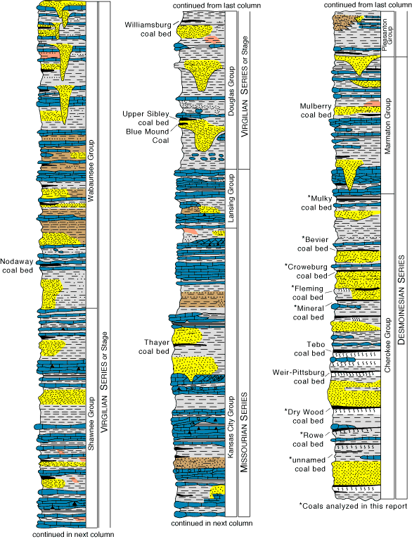
Figure 2—Location of coal samples used in this study (location description and coal-bed details are listed in table 1), and the general distribution of strippable coal resources by geologic group for coals under 30 m (100 ft) of overburden or less. Map is modified from Brady et al. (1976).
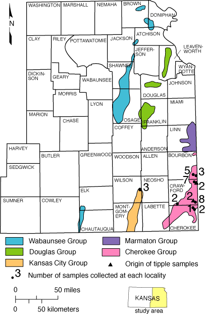
Figure 3—Location of western and eastern regions of the Interior Coal Province as discussed in the report. Map is modified from Wood and Bour (1988).
Brady et al. (1976) estimated strippable coal resources of 2.8 billion tons in 17 different Middle and Upper Pennsylvanian coals; Brady and Livingston (1989) and Brady (1990) estimated deep coal resources (30 m, 100 ft) in Kansas to be at least 50 billion tons in 32 coal beds. The present study includes samples from nine coal beds with significant strippable resources. These coals include the Rowe, Dry Wood, Mineral, Croweburg, Bevier, Mulky, Thayer, Upper Williamsburg, and an unnamed but extensively mined coal that is present a short distance beneath the Rowe coal.
Except for those elements commonly reported in the ultimate analysis of coal (S, C, H, O, and N), previous analyses of the chemical composition of Kansas coals are limited. Schleicher and Hambleton (1954) analyzed 24 samples from six Middle Pennsylvanian Kansas coals—Tebo, Mineral, Croweburg, Bevier, Mulky and Mulberry coals (see fig. 1 for relative stratigraphic positions)—for germanium (Ge) content. They found germanium content ranging from 6.9 to 48 ppm, with the Mulky coal sample in Bourbon County and a Mulberry coal sample in Linn County having the highest concentrations (41 ppm and 48 ppm, respectively). A later study by Schleicher (1959) on 20 different Middle and Upper Pennsylvanian Kansas coal beds showed germanium content to range from 6 to 116 ppm. These analyses showed generally higher germanium content in those coals higher in the stratigraphic section; for example, the 23 samples of Nodaway coal from the Upper Pennsylvanian (Virgilian) Wabaunsee Group had a mean germanium content of 51 ppm, and seven samples of Upper Williamsburg coal from the Upper Pennsylvanian (Virgilian) Douglas Group had a mean germanium content of 52 ppm.
Analyses of the major and minor oxide composition of two Kansas coal ash samples were included in a summary report on major ash constituents in U.S. coals by Abernethy et al. (1969, p. 4). Information on the major and minor elements of the Mulberry, Mulky, Croweburg, Fleming, Mineral, Tebo, Weir-Pittsburg, Drywood (spelled Dry Wood in Kansas), and Rowe coals in southwestern Missouri and the Bevier, Croweburg, and Rowe coals in northeastern Oklahoma that have stratigraphic continuity into Kansas is presented in Zubovic et al. (1967), Swanson et al. (1976), Wedge et al. (1976), Wedge and Hatch (1980), Burchett (1977), Finkelman et al. (1990), and Tewalt and Finkelman (1990). The Mulberry coal analyses obtained from samples collected in Bates County, Missouri by Wedge and Hatch (1980) are relevant to the characterization of Kansas coals because the locations are within 2 mi (3.2 km) of the Linn County, Kansas, area where the Mulberry coal has been extensively mined.
Mineral content in Kansas coals was discussed as part of a larger study by Hambleton (1953, p. 50-61) on the petrography of the Mineral, Croweburg, and Bevier coals. Detrital minerals determined in that study included quartz, clay minerals, and apatite with authigenic minerals consisting of calcite, aragonite, pyrite, marcasite, and minor amounts of sphalerite. Hatch, Avcin et al. (1976) and Cobb (1981) identified sphalerite in the Mineral, Croweburg, and Mulky coals in Kansas after preliminary sample analyses of these beds indicated high zinc contents. Sphalerite was also identified in the Mineral and Mulberry coals a few miles from the Kansas border in Vernon and Bates counties, Missouri. Based on X-ray diffraction work, Finkelman et al. (1990, p. 36) characterized the mineralogy of eight coal samples (including samples from the Mineral, Croweburg, and Bevier coals), showing the main minerals to be calcite and pyrite.
Part of the data listed in this report were published in three earlier reports. These include analyses of 14 samples in Swanson et al. (1976, p. 279-287), zinc and cadmium analyses for 16 samples in Hatch, Avcin et al. (1976), and proximate, ultimate, and trace element analyses of six samples of Rowe and Dry Wood coals in Welch and Brady (1982, p. 22-25). A summary paper of analytical data on coals from the western region of the Interior Coal Province by Finkelman and Tewalt (1990) included a summary of Kansas coal samples in addition to summaries of samples from Arkansas, Iowa, Missouri, Nebraska, and Oklahoma.
Of the 36 samples reported in this study, 32 are from Middle Pennsylvanian (Desmoinesian) coals from the Cherokee Group (table 1). The other four coal samples are from Upper Pennsylvanian rocks, three of these from the Missourian Thayer coal and one from the Virgilian Upper Williamsburg coal. Sample locations and number of samples collected at each locality are shown in fig. 2. Listed in table 1 are the sample identification numbers, locations, names and thicknesses of beds, and sample types.
All samples except one were collected from active strip mines. The one exception is a grab sample from the Upper Williamsburg coal, which was collected from a new pond excavation. A total of 31 channel samples representing the full thickness of the bed, one grab sample, and four tipple samples (from coal that passed through the coal cleaning plant) are included in this study.
Analyses performed on the coal samples from southeastern Kansas are listed by laboratory in fig. 4. Determinations of proximate and ultimate analyses, heat of combustion, air-dried loss, forms of sulfur, ash-fusion temperatures, and free-swelling index were supplied by the U.S. Bureau of Mines, Pittsburgh, Pennsylvania. Analytical procedures for these analyses are described in the U.S. Office of Coal Research (1967). The analytical procedures used by the U.S. Geological Survey for elemental analyses are described in Swanson and Huffman (1976). A flow chart showing the sequence of sample preparation and chemical analyses is shown in fig. 5. Listed in table 2 are those additional elements for which coals were analyzed, but whose values were below the detection limits of the six-step spectrographic methods. Changes in the X-ray fluorescence technique to determine phosphorus content in ash resulted in variable lower detection limits. For samples D176045-D176058, the lower detection limit is 0.04% phosphorus (0.1% P2O5). For samples analyzed later (D196196-D196199), the lower detection limit is 0.004% phosphorus (0.01% P2O5). For the other samples, however, the lower detection limit is 0.4% phosphorus (1.0% P2O5). Thorium content of samples D189091, D189704-D189706, and D196196-D196199 was determined by instrumental neutron activation analysis and this method provides a lower detection limit of 0.1 ppm; the remaining 28 samples were analyzed by delayed-neutron activation analysis and have a lower detection limit of 3.0 ppm.
Figure 4—Analyses and physical tests performed by government laboratories.
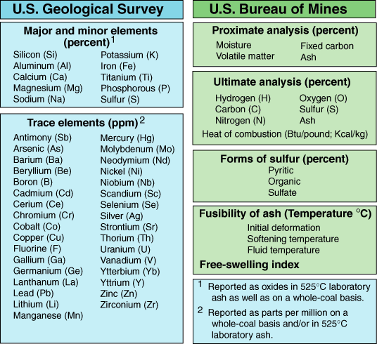
Figure 5. Flow chart showing sequence of sample preparation and chemical analysis. Modified from Swanson and Huffman (1976, fig. 1).
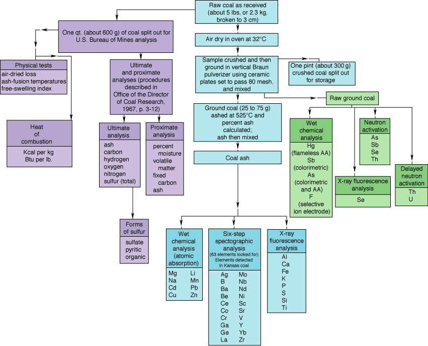
Table 2—Elements looked for but not detected in Pennsylvanian coal samples from southeastern Kansas. (Approximate lower detection limits in coal ash as determined by the six-step spectrographic method of the U.S. Geological Survey are included for all elements.)
| Element name | Symbol | Lower limit of detection (ppm) in ash |
|---|---|---|
| Gold | Au | 50 |
| Bismuth | Bi | 20 |
| Dysprosium | Dy | 100 |
| Erbium | Er | 100 |
| Europium | Eu | 200 |
| Gadolinium | Gd | 100 |
| Hafnium | Hf | 200 |
| Holmium | Ho | 50 |
| Indium | In | 20 |
| Lutetium | Lu | 70 |
| Palladium | Pd | 5 |
| Praseodymium | Pr | 200 |
| Platinum | Pt | 100 |
| Rhenium | Re | 100 |
| Smarium | Sm | 200 |
| Tin | Sn | 20 |
| Tantalum | Ta | 1,000 |
| Terbium | Tb | 700 |
| Tellurium | Te | 5,000 |
| Thallium | Tl | 100 |
| Thulium | Tm | 50 |
| Tungsten | W | 200 |
In this report, the geometric mean (GM) is used as the estimate of the most probable concentration (mode). The geometric mean was calculated by taking the logarithm of each analytical value, summing the logarithms, dividing the sum by the total number of values, and obtaining the antilogarithm of the result. The geometric deviation (GD), which is the antilog of the standard deviation of the logarithms of the analytical values, was used to measure scatter about the mode. These statistics were used because quantities of trace elements in natural materials commonly exhibit positively skewed frequency distributions; such distributions are normalized by analyzing and summarizing trace-element data on a logarithmic basis. If the frequency distributions are log-normal, the geometric mean is the best estimate of the mode, and the estimated range of the central two-thirds of the observed distribution has a lower limit equal to GM/GD and an upper limit equal to GM X GD. The estimated range of the central 95% of the observed distribution has a lower limit equal to GM/GD2 and an upper limit equal to GM X GD2 (Conner et al., 1976).
Although the geometric mean is generally an adequate estimate of the most common analytical value in log-normal populations, it is nevertheless a biased estimate of the arithmetic mean. The estimates of the arithmetic means, as listed in the summary tables (tables 3, 4, 5, 6, 7), are Sichel's t-statistic (Miesch, 1967). The common problem of a "censored" distribution arises in statistical summaries of trace-element data when the element content of one or more of the samples is below or greater than the limits of analytical detection. Procedures developed by Cohen (1959) were used to compute unbiased estimates of the geometric mean, geometric deviation, and arithmetic mean when the data are "censored."
Table 3—Results of proximate and ultimate analyses of 25 Pennsylvanian coal samples from southeastern Kansas. (All values are reported on the as-received basis.)
| Arithmetic mean (%) |
Minimum observed range (%) |
Maximum observed range (%) |
Geometric mean (%) |
Geometric deviation |
|
|---|---|---|---|---|---|
| Moisture | 3.3 | 1.7 | 8.1 | 3.1 | 1.4 |
| Volatile matter | 35.3 | 28.2 | 39.9 | 35.1 | 1.1 |
| Fixed carbon | 45.9 | 37.0 | 52.6 | 45.8 | 1.1 |
| Ash | 15.5 | 6.7 | 31.1 | 14.7 | 1.4 |
| Hydrogen | 4.9 | 3.8 | 5.6 | 4.9 | 1.1 |
| Carbon | 65.3 | 47.8 | 71.3 | 65.0 | 1.1 |
| Nitrogen | 1.2 | 0.8 | 1.9 | 1.2 | 1.2 |
| Oxygen | 7.7 | 3.7 | 13.3 | 7.3 | 1.4 |
| Sulfur | 5.5 | 1.6 | 12.8 | 4.9 | 1.6 |
Table 4—Heat of combustion results for 25 Pennsylvanian coal samples from southeastern Kansas. (All values are reported on the as-received basis. Kcal/kg = 0.556 Btu/lb.)
| Arithmetic mean (%) |
Minimum observed range (%) |
Maximum observed range (%) |
Geometric mean (%) |
Geometric deviation | |
|---|---|---|---|---|---|
| Kcal/kg | 6,620 | 5,160 | 7,100 | 6,600 | 1.1 |
| Btu/lb | 11,910 | 9,290 | 12,780 | 11,870 | 1.1 |
Table 5—Forms of sulfur in 25 Pennsylvanian coal samples from southeastern Kansas. (All values are reported on the as-received basis.)
| Arithmetic mean (%) |
Minimum observed range (%) |
Maximum observed range (%) |
Geometric mean (%) |
Geometric deviation | |
|---|---|---|---|---|---|
| Pyritic | 3.82 | 0.57 | 10.7 | 3.03 | 2.0 |
| Organic | 1.42 | 0.50 | 2.95 | 1.25 | 1.6 |
| Sulfate | 0.50 | 0.01 | 0.96 | 0.20 | 4.0 |
Table 6—Concentrations of ash and nine major and minor oxides in the laboratory ash of 32 Pennsylvanian coal samples from southeastern Kansas. All samples were ashed at 525°C.
| Arithmetic mean (%) |
Minimum observed range (%) |
Maximum observed range (%) |
Geometric mean (%) |
Geometric deviation | |
|---|---|---|---|---|---|
| (Ash) | 16.2 | 7.6 | 32.3 | 15.6 | 1.3 |
| SiO2 | 26 | 13 | 42 | 25 | 1.3 |
| Al2O3 | 11 | 1.6 | 21 | 9.4 | 1.7 |
| CaO | 9.6 | 0.31 | 30 | 4.8 | 4.1 |
| MgO | 0.68 | 0.29 | 1.53 | 0.63 | 1.5 |
| Na2O | 0.28 | 0.07 | 0.77 | 0.25 | 1.7 |
| K2O | 1.5 | 0.50 | 3.1 | 1.3 | 1.6 |
| Fe2O3 | 34 | 11 | 59 | 31 | 1.5 |
| TiO2 | 0.49 | 0.09 | 1.0 | 0.42 | 1.7 |
| SO3 | 6.9 | 1.4 | 16 | 5.2 | 2.1 |
Table 7—Concentrations of 35 elements in 32 Pennsylvanian coal samples from southeastern Kansas (tipple samples listed in Appendix B are not included). Concentrations of the first eight elements are given in percentages; the rest are in parts per million. All analyses are reported on a whole coal basis. As, F, Hg, Sb, Se, Th, and U values used to calculate the statistics were determined directly on whole coal. All other values used were calculated from determinations made on coal ash. L = less than the value shown; G = greater than the value shown.
| Element | Arithmetic mean |
Observed minimum range |
Observed maximum range |
Geometric mean |
Geometric deviation |
|---|---|---|---|---|---|
| percentages | |||||
| Si | 1.9 | 0.75 | 4.6 | 1.8 | 1.5 |
| Al | 0.91 | 0.22 | 2.4 | 0.77 | 1.8 |
| Ca | 1.4 | 0.046 | 4.2 | 0.54 | 4.0 |
| Mg | 0.065 | 0.029 | 0.22 | 0.059 | 1.6 |
| Na | 0.032 | 0.017 | 0.13 | 0.029 | 1.6 |
| K | 0.19 | 0.057 | 0.53 | 0.17 | 1.6 |
| Fe | 3.9 | 0.60 | 7.5 | 3.4 | 1.7 |
| Ti | 0.046 | 0.008 | 0.14 | 0.040 | 1.7 |
| parts per million | |||||
| Ag | 0.3 | 0.2 | 0.7 | 0.2 | 1.9 |
| As | 26 | 6.8 | 60 | 22 | 1.8 |
| B | 30 | 7 | 200 | 20 | 2.0 |
| Ba | 30 | 7 | 150 | 30 | 1.9 |
| Be | 1.5 | 0.7 | 3 | 1.5 | 1.4 |
| Cd | 20 | 0.1L | 160 | 0.15 | 53 |
| Co | 10 | 1.5 | 70 | 7 | 2.6 |
| Cr | 10 | 2 | 30 | 10 | 1.6 |
| Cu | 27 | 5.5 | 75 | 26 | 1.6 |
| F | 88 | 30 | 330 | 76 | 1.7 |
| Ga | 5 | 1.5 | 30 | 5 | 2.3 |
| Ge | 15 | 5 | 50 | 15 | 1.5 |
| Hg | 0.16 | 0.06 | 0.83 | 0.14 | 1.6 |
| Li | 8.9 | 1.5 | 25 | 6.1 | 2.4 |
| Mn | 140 | 21 | 460 | 90 | 2.5 |
| Mo | 3 | 1 | 10 | 2 | 2.9 |
| Ni | 50 | 2 | 150 | 20 | 2.6 |
| Pb | 97 | 27 | 210 | 84 | 1.7 |
| Sb | 1.8 | 0.2 | 5.0 | 1.3 | 2.2 |
| Sc | 2 | 1L | 5 | 2 | 1.6 |
| Se | 3.3 | 0.5 | 9.7 | 2.7 | 2.0 |
| Sr | 70 | 10 | 5,000G | 50 | 3.0 |
| U | 3.2 | 0.2L | 25 | 1.6 | 3.4 |
| V | 20 | 2 | 150 | 15 | 2.1 |
| Y | 15 | 2 | 70 | 10 | 2.1 |
| Zn | 600 | 13 | 51,000 | 77 | 8.0 |
| Zr | 10 | 3 | 30 | 10 | 1.8 |
Because lower detection limits vary, data summaries for P2O5 in coal ash (table 6) and phosphorous and thorium in whole coal were not calculated (table 7; see table 9). Five elements (Ce, La, Nb, Nd, and Yb) were detected in some samples, but not in enough samples to calculate meaningful statistics. To be consistent with the precision of the semiquantitative emission spectrographic technique, arithmetic and geometric means of elements determined by this method are reported as the midpoint of the enclosing six-step brackets. The tipple samples D183117-D183120 were excluded from all the data summaries.
Proximate and ultimate analyses, heat of combustion, air-dried loss, forms of sulfur, free-swelling index, and ash-fusion temperatures were determined for 29 Kansas coal samples (appendix A). The 29 samples include 19 individual channel coal samples, six samples that are composites (where two or three channel samples collected from the same coal bed in the same mine were combined), and the four tipple samples (samples D183117-D183120). The laboratory ash of all 36 coal samples was analyzed for major- and minor-oxide and trace-element composition (appendix B). Thirty-six samples of coal were also analyzed for 42 elements (appendix C). Unweighted statistical summaries of the analytical data for the 31 channel samples and one grab sample listed in appendices A, B, and C (excluding the four tipple samples) are listed in tables 3, 4, 5, 6, 7.
Proximate analyses for the individual coal beds (on an as-recieved basis) are summarized in table 8. All values are arithmetic means. The concentration of volatile matter ranges from 30.1% in the Dry Wood bed to 39.7% in the Upper Williamsburg coal, averaging 35.3% for the 25 Kansas coals listed in appendix A (tipple samples excluded). Fixed-carbon composition ranges from 41.3% for the Dry Wood and Thayer coals to 50.4% for the samples from the unnamed coal bed in the lower part of the Cherokee Group, the mean value for all 25 coal samples being 45.9%. Ash content can be quite variable within a coal bed as well as between coal beds. The lowest ash content is 6.7% for the grab sample from the Upper Williamsburg coal. This sample, however, did not represent the full thickness of the bed. Where the entire thickness of the coal was sampled, the Mulky coal has the lowest mean ash content (11.4%), and the Dry Wood coal has the highest (25.6%). The mean ash content for all 25 channel samples of coal is 15.5%. Mechanical coal-cleaning plants can greatly reduce the percentage of ash present in mined coal. The tipple samples of coal from four different coal beds—Rowe (D183117), Dry Wood (D183118), Mineral (D183119), and Croweburg (D183120)—that had passed through a coal-cleaning plant have 16-38% less ash than the uncleaned samples from the same coal bed. The mean moisture content for different coal beds ranges from 2.7% in the Croweburg coal up to 6.8% in the Thayer coal. The mean moisture content for the 25 samples is 3.3%. Moisture content of coal samples is dependent on coal rank and to a lesser extent on the sampling technique. Exposure of the coal to the atmosphere after sampling strongly affects the measured moisture content (American Society for Testing and Materials, 1993, standard D2234). Of the samples collected, only the Upper Williamsburg coal sample was air-dried before analysis.
Table 8—Arithmetic means and standard deviations of the results of proximate analyses, heat of combustion, and sulfur analyses by coal bed. (*Moisture and mineral-matter free.)
| Coal bed | n | % Moisture | % Volatile matter | %Fixed carbon | % Ash | % Sulfur | As-received (Btu) | m & mm free* (Btu) | |||||||
|---|---|---|---|---|---|---|---|---|---|---|---|---|---|---|---|
| mean | SD | mean | SD | mean | SD | mean | SD | mean | SD | mean | SD | mean | SD | ||
| U. Williamsburg | 1 | 3.3 | --- | 39.7 | --- | 50.3 | --- | 6.7 | --- | 1.6 | --- | 12,550 | --- | 13,940 | --- |
| Thayer | 2 | 6.8 | 1.8 | 33.7 | 3.9 | 41.3 | 0.6 | 18.3 | 2.7 | 3.85 | 0.78 | 10,675 | 685 | 14,250 | 60 |
| Mulky | 5 | 3.0 | 0.3 | 38.3 | 2.7 | 47.4 | 3.0 | 11.4 | 0.7 | 4.60 | 0.29 | 12,695 | 100 | 14,820 | 115 |
| Bevier | 2 | 3.9 | 0.1 | 36.1 | 1.1 | 48.6 | 0.2 | 11.5 | 1.1 | 2.70 | 0.42 | 12,250 | 270 | 14,480 | 100 |
| Croweburg | 4 | 2.7 | 0.9 | 35.4 | 2.7 | 43.7 | 2.6 | 18.3 | 4.4 | 4.28 | 0.8 | 11,680 | 725 | 14,785 | 95 |
| Mineral | 3 | 2.8 | 0.6 | 36.1 | 0.7 | 47.8 | 1.9 | 13.2 | 0.9 | 4.70 | 0.10 | 12,575 | 155 | 14,980 | 140 |
| Dry Wood | 2 | 3.1 | 0.9 | 30.1 | 2.6 | 41.3 | 6.1 | 25.6 | 7.9 | 10.35 | 3.46 | 10,310 | 1,440 | 14,435 | 260 |
| Rowe | 5 | 3.0 | 1.1 | 34.1 | 0.9 | 46.1 | 2.7 | 16.9 | 3.7 | 8.77 | 2.50 | 11,725 | 555 | 14,615 | 205 |
| Unnamed | 1 | 3.3 | --- | 31.2 | --- | 50.4 | --- | 15.1 | --- | 4.1 | --- | 12,060 | --- | 14,780 | --- |
| All beds | 25 | 3.3 | 1.3 | 35.3 | 3.1 | 45.9 | 3.6 | 15.5 | 5.2 | 5.36 | 2.54 | 11,910 | 895 | 14,655 | 390 |
Heat of combustion for individual Kansas coal beds is also summarized in table 8. The mean heat of combustion (as-received basis) ranges from 10,310 Btu/lb for the Dry Wood coal to 12,695 Btu/lb for the Mulky coal and averages 11,910 Btu/lb for all 25 channel samples. Heat of combustion is related to coal rank and is also significantly affected by moisture and ash content. For a moisture- and ash-free basis, heat of combustion ranges from 13,940 Btu/lb for the Upper Williamsburg coal to 14,980 Btu/lb for Mineral coal samples.
Ultimate analyses of the 25 coal samples show arithmetic means (as-received basis) of 4.9% hydrogen, 65.3% carbon, 1.2% nitrogen, 7.7% oxygen, and 5.5% sulfur (table 3). The sulfur content of Kansas coal is generally high (greater than 2.0%). As table 8 shows, the samples with the lowest sulfur content were Bevier coal (arithmetic mean of 2.7%) and Upper Williamsburg coal (1.6%). The highest sulfur content was in samples of the Dry Wood coal (10.4%) and Rowe coal (8.8%). Where these coals were sampled, considerable pyrite was observed along bedding planes and cleats, with pyrite bands along bedding planes as thick as 0.4 inches (1 cm). The mean pyritic sulfur content in the Dry Wood coal is 7.4%; in the Rowe coal, it is 6.9% (based on sample data in appendix A). The relatively low sulfur content (for Kansas coals) of the Upper Williamsburg (one grab sample) and Bevier coal (two channel samples) is similar to analyses published by Hamilton et al. (1975, p. 292). Their compilation of all available sulfur sample values showed that 22 samples of Bevier coal from Cherokee County (on an as-received basis) averaged 2.6% sulfur, whereas 133 Bevier coal samples from Crawford County averaged 2.0%. Five Upper Williamsburg samples listed in Hamilton et al. (1975) averaged 1.7% sulfur (moisture-free basis). In analyses listed by Bowsher and Jewett (1943, p. 57) for Upper Williamsburg coal from three different mines (as-received basis), sulfur content averaged 1.6%.
Apparent ranks for the 25 coal samples were calculated using the approximation Parr formulas (American Society for Testing and Materials, 1993, p. 202, standard D-388). Calculated apparent rank (moist, mineral-matter-free Btu values) for these samples range from high-volatile B bituminous to high-volatile A bituminous coal. Except for composite sample D196198-D196199, all coal samples from the Cherokee Group in southeastern Kansas (Cherokee, Crawford, and Bourbon counties) have an apparent rank of high-volatile A bituminous coal; whereas samples of younger coals (Thayer and Upper Williamsburg) from Wilson and Franklin counties have an apparent rank of high-volatile B bituminous coal.
Table 9 summarizes the geometric means and the geometric deviations for 35 minor and trace elements in coals from southeastern Kansas. For comparison, this information is also listed for equivalent-aged coal samples from Oklahoma, Iowa, and Missouri. The Oklahoma coals were associated with a rapidly subsiding basin, whereas the Kansas, southwest Missouri, and Iowa samples were from coals associated mainly with shelf deposits. Also included in table 9 are geometric mean values of the trace elements in Interior Province (Swanson et al., 1976, p. 223) and U.S. coals (Finkelman and Tewalt, 1990, p. 213).
Table 9. Concentrations of 35 elements in coal samples from Kansas, Iowa, the southwest coal region of Missouri, the Arkoma basin of Oklahoma, the Interior Coal Province, and the U.S. (n = number of samples). Geometric mean (GM) and geometric deviation (GD) values are shown for all the samples except for those from the U.S. coal database, for which only the geometric mean is given. Concentrations of the first eight elements are given in percentages; the rest are in parts per million.
| Element | Kansas | Oklahoma1 | Iowa2 | Missouri3 | Interior Province4 | U.S.5 | |||||
|---|---|---|---|---|---|---|---|---|---|---|---|
| GM | GD | GM | GD | GM | GD | GM | GD | GM | GD | GM | |
| percentages | |||||||||||
| Si | 1.8 | 1.5 | 1.1 | 2.7 | 1.7 | 1.9 | 2.4 | 1.5 | 1.4 | 2.3 | --- |
| Al | 0.77 | 1.8 | 0.74 | 2.7 | 0.78 | 2.0 | 0.97 | 1.7 | 0.77 | 2.0 | --- |
| Ca | 0.54 | 4.0 | 0.38 | 3.1 | 1.2 | 2.3 | 0.39 | 4.1 | 0.50 | 3.8 | --- |
| Mg | 0.059 | 1.6 | 0.12 | 2.6 | 0.045 | 2.0 | 0.069 | 1.4 | 0.063 | 2.3 | --- |
| Na | 0.029 | 1.6 | 0.031 | 2.6 | 0.026 | 1.8 | 0.024 | 1.6 | 0.026 | 2.2 | --- |
| K | 0.17 | 1.6 | 0.1 | 2.9 | 0.10 | 2.1 | 0.19 | 1.7 | 0.11 | 2.4 | --- |
| Fe | 3.4 | 1.7 | 1.4 | 2.3 | 4.0 | 2.0 | 2.8 | 1.3 | 2.3 | 2.4 | --- |
| Ti | 0.040 | 1.7 | 0.033 | 2.4 | 0.040 | 2.0 | 0.051 | 1.8 | 0.04 | 2.1 | --- |
| parts per million | |||||||||||
| Ag | 0.2 | 1.9 | --- | --- | 0.05 | 8.1 | 0.15 | 1.5 | --- | --- | 0.01 |
| As | 22 | 1.8 | 11 | 4.2 | 15 | 2.5 | 14 | 1.9 | 12 | 2.9 | 6.5 |
| B | 20 | 2.0 | 15 | 3.0 | 100 | 1.6 | 20 | 1.6 | 50 | 3.4 | 30 |
| Ba | 30 | 1.9 | 50 | 2.1 | 30 | 3.6 | 30 | 1.7 | 30 | 2.6 | 90 |
| Be | 1.5 | 1.4 | 0.5 | 4.0 | 2 | 1.5 | 1.5 | 1.5 | 1.5 | 3.1 | 1 |
| Cd | 0.15 | 53 | --- | --- | 0.4 | 17 | 0.37 | 52 | 0.12 | 18.3 | 0.02 |
| Co | 7 | 2.6 | --- | --- | 7 | 2.5 | 10 | 1.6 | 7 | 2.3 | 4 |
| Cr | 10 | 1.6 | 10 | 2.6 | 15 | 2.1 | 15 | 1.8 | 10 | 2.0 | 11 |
| Cu | 26 | 1.6 | 13 | 1.9 | 19 | 2.0 | 24 | 1.3 | 16.3 | 1.9 | 12 |
| F | 76 | 1.7 | 61 | 2.0 | 65 | 1.8 | 78 | 1.6 | 58 | 1.9 | 35 |
| Ga | 5 | 2.3 | 3 | 2.4 | 7 | 1.8 | 7 | 1.8 | 3 | 2.0 | 5 |
| Ge | 15 | 1.5 | --- | --- | 20 | 1.7 | 10 | 1.4 | --- | --- | 0.6 |
| Hg | 0.14 | 1.6 | 0.08 | 4.6 | 0.14 | 1.7 | 0.14 | 1.6 | 0.10 | 2.3 | 0.10 |
| Li | 6.1 | 2.4 | 7.4 | 3.5 | 7.9 | 2.8 | 7.1 | 2.6 | 7.0 | 2.7 | 9.2 |
| Mn | 90 | 2.5 | 59 | 2.7 | 170 | 2.0 | 71 | 2.4 | 72 | 3.1 | 19 |
| Mo | 2 | 2.9 | 3 | 3.1 | 3 | 3.7 | 2 | 3.2 | 2 | 2.8 | 1 |
| Ni | 20 | 2.6 | 15 | 2.0 | 30 | 2.3 | 30 | 1.5 | 18 | 2.4 | 9 |
| Pb | 84 | 1.7 | 3.3 | 3.1 | 44 | 2.5 | 64 | 2.0 | 19 | 4.3 | 5.0 |
| Sb | 1.3 | 2.2 | 0.3 | 2.4 | 0.8 | 4.0 | 1.1 | 2.9 | 0.8 | 3.4 | 0.61 |
| Sc | 2 | 1.6 | 2 | 2.5 | 5 | 2.1 | 3 | 1.4 | 3 | 2.1 | 3 |
| Se | 2.7 | 2.0 | 1.2 | 2.5 | 2.8 | 2.7 | 4.1 | 2.6 | 2.8 | 2.7 | 1.8 |
| Sr | 50 | 3.0 | 50 | 2.3 | 50 | 2.6 | 20 | 1.6 | 30 | 2.8 | 90 |
| U | 1.6 | 3.4 | 0.7 | 4.3 | 2.4 | 3.1 | 2 | 2.9 | 1.4 | 3.8 | 1.1 |
| V | 15 | 2.1 | 20 | 2.6 | 20 | 2.4 | 20 | 1.8 | 20 | 2.1 | 20 |
| Y | 10 | 2.1 | 7 | 2.3 | 10 | 1.7 | 10 | 1.6 | 7 | 1.9 | 7 |
| Zn | 77 | 8.0 | 23 | 2.1 | 150 | 7.5 | 170 | 12 | 58 | 6.9 | 13 |
| Zr | 10 | 1.8 | --- | --- | 15 | 2.0 | 15 | 1.6 | 10 | 2.0 | 19 |
| n | 32 | 51 | 105 | 22 | 143 | * | |||||
| 1 Data from Hildebrand, 1981, p. 42. 2 Data from Hatch et al., 1984, p. 101. 3 Data from Wedge and Hatch, 1980, p. 98-99. 4 Data from Swanson et al., 1976, p. 223. 5 Data from Finkelman and Tewalt, 1990, p. 213. * U.S. sample number varies by element, 5,000› to ‹8,000 |
|||||||||||
Geometric means of minor- and trace-element values in the samples from Kansas were compared with those in coal samples from Oklahoma (Arkoma basin area, Hildebrand, 1981, p. 42), Iowa (Hatch et al., 1984, p. 101), and southwestern Missouri (Wedge and Hatch, 1980, p. 98-99). Based on the t-test (99% confidence level), when compared to coals from adjacent states and the Interior Province coals, Kansas coals have significantly higher concentrations of As, Cu, and Pb and lower concentrations of V. Compared to Interior Province coals (Swanson et al., 1976), Kansas coals also have higher concentrations of F, Ga, Mn, Ni, Sr, Y and Zn and a lower concentration of B. Additionally, the Iowa coals have higher concentrations of B, Cr, Ga, Ge, Li, Mn, Ni, V, Zn, and Zr. Compared with coals from the Arkoma basin in eastern Oklahoma, Kansas coals have higher concentrations of Fe, B, F, Ga, Mn, Ni, Se, Y, and Zn and lower Ba content. Kansas coals also have significantly higher concentrations of Ge, Mn, Sr and lower concentrations of Co, Cr, F, Ga, Ni, Zn, and Zr than coals from the southwest mining district of Missouri. As table 9 shows, Kansas coals have more than 16 times the lead content of U.S. coals and five or more times more Ag, Cd, Ge, and Zn.
To relate the variation of 42 minor and trace elements in the 31 channel samples, correlation coefficients were calculated from the data in appendix C. These are shown in appendix D. No less than eight analytical values were used in the correlation analyses. The number of pairs used to calculate each correlation coefficient is also listed in appendix D.
Eleven elements in Kansas coals show strong correlation with ash content (appendix D). At the 99% confidence level, ash shows significant positive correlation with Co, Cu, Fe, Ga, Si, and Y. At the 95% confidence level, ash is also correlated with Ba, Li, Mg, Sc, and Zr.
Limited information is available about silver content in U.S. coals. In their study of Interior Province coals, Swanson et al. (1976) did not list average silver content. For Missouri coals, Wedge and Hatch (1980) showed silver values for four separate coal-mining districts. Seventeen samples from coal beds in the southwest district of Missouri, which are continuous with coal deposits of southeastern Kansas, show a geometric mean of 0.15 ppm with a range of less than 0.15 to 0.3 ppm (Wedge and Hatch, 1980, p. 98). This concentration is similar to that seen in southeastern Kansas coals, where geometric mean silver content is 0.2 ppm and ranges from less than 0.2 ppm to 0.7 ppm. Silver shows no positive correlation at the 95% confidence level with other elements analyzed in this study (appendix D).
Lead content in Kansas coals ranges from 27 to 210 ppm and has a geometric mean of 84 ppm, as compared to a geometric mean of 19 ppm in coals from the Interior Province (table 9). Coals from the southwest district of Missouri have a geometric mean content of 64 ppm and a range of 23 to 280 ppm (Wedge and Hatch, 1980, p. 99), similar to the range and mean lead content in Kansas coals. In Kansas coals, lead has a strong positive correlation (99% or greater confidence level) with iron and copper; at the 95% confidence level, lead has a positive correlation with molybdenum.
The relatively high germanium content in some Kansas coals was first recognized by Schleicher and Hambleton (1954) and Schleicher (1959), who found germanium concentrations ranging from 6 to 116 ppm. In this study, germanium content ranges from 5 to 50 ppm, with a geometric mean of 15 ppm (table 7). In coals from the southwestern district of Missouri, germanium content ranges from 5 to 20 ppm, with a geometric mean of 10 ppm (Wedge and Hatch, 1980, p. 98). For the Kansas coal analyses reported here, germanium has a strong positive correlation with boron (99% or greater confidence level) and calcium (95% confidence level).
These two elements are present in high amounts in coals from the Interior Coal Province, with a geometric mean content of 58 ppm for zinc and 0.12 ppm for cadmium. These values are nearly five times higher than in U.S. coals, where zinc averages 13 ppm and cadmium 0.02 ppm. Of the four states reviewed (table 9), the Oklahoma samples have the lowest zinc and cadmium content. Wide ranges of zinc and cadmium content are indicated by the large geometric deviation values in Kansas, southwest Missouri, and Iowa (table 9). These extreme values in the Kansas samples are discussed below. Zinc shows a strong positive correlation with cadmium and mercury at the 99% confidence level or higher, and with gallium and molybdenum at the 95% confidence level. Cadmium shows a positive correlation with arsenic, chromium, gallium, and antimony at the 95% confidence level, and with mercury and zinc at the 99% or higher confidence level.
Arsenic content in Kansas coals is significantly higher than in coals from surrounding states, the Interior Province, and the U.S. as a whole (table 9). At the 99% confidence level, arsenic shows a strong positive correlation with Al, Cr, Cu, Fe, Li, Ti, and V and with K and Zr at the 95% confidence level.
Copper content in Kansas coal is also higher than in coal samples from states adjacent to Kansas, the Interior Province, and the U.S. In Kansas coals copper has a strong positive correlation with Al, As, Co, Cr, Fe, Hg, Li, Pb, V, and Y at the 99% confidence level and with Ga, Ni, Ti, and Zr at the 95% confidence level.
High concentrations of minor and trace elements are considered to be statistical outliers when those element quantities in individual coal analyses exceed the 95% central distribution range of GM X GD2 for the given element. A total of 31 outlier occurrences of trace or minor elements were present in 13 different Kansas coal samples (table 10). Coals from the Thayer and Dry Wood beds had the most outliers, 13 and nine, respectively.
Table 10—Anomalous individual minor- and trace-element occurrence (statistical outliers) in Kansas coal samples when compared with the estimated upper distribution of the samples.
| Element | Upper limit 95% range |
Sample value |
Sample no. |
Coal bed |
|---|---|---|---|---|
| percentages | ||||
| Si | 4.1 | 4.6 | D183114 | Croweburg |
| Mg | 0.15 | 0.22 | D176057 | Thayer |
| Na | 0.07 | 0.089 | D176055 | Thayer |
| 0.13 | D176057 | Thayer | ||
| K | 0.44 | 0.53 | D176057 | Thayer |
| Ti | 0.12 | 0.14 | D176057 | Thayer |
| parts per million | ||||
| B | 80 | 200 | D176058 | U. Williamsburg |
| Ba | 108 | 150 | D176057 | Thayer |
| Be | 2.9 | 3 | D180069 | Rowe |
| 3 | D180071 | Rowe | ||
| Cd | 40* | 44 | D183112 | Mineral |
| 160 | D180074 | Dry Wood | ||
| Co | 47 | 70 | D180072 | Dry Wood |
| Cr | 26 | 30 | D176057 | Thayer |
| Cu | 67 | 75 | D180074 | Dry Wood |
| F | 220 | 295 | D176056 | Thayer |
| 330 | D176057 | Thayer | ||
| Ga | 26 | 30 | D180074 | Dry Wood |
| Ge | 34 | 50 | D176058 | U. Williamsburg |
| Hg | 0.36 | 0.83 | D180074 | Dry Wood |
| Sr | 450 | 5,000G | D176055 | Thayer |
| 700 | D176056 | Thayer | ||
| 1,000 | D176057 | Thayer | ||
| U | 18 | 22 | D176056 | Mulky |
| 25 | D196197 | Mulky | ||
| V | 66 | 150 | D176057 | Thayer |
| Y | 44 | 70 | D180072 | Dry Wood |
| 50 | D180074 | Dry Wood | ||
| Zn | 4,930 | 5,800 | D183112 | Mineral |
| 5,300 | D180072 | Dry Wood | ||
| 51,000 | D180074 | Dry Wood | ||
| * Interior Province data (Swanson et al., 1976, p. 223) was used for calculating Cd 95% limit because of wide range of Cd values in Kansas samples would not allow a meaningful 95% limit to be developed on Kansas Cd data alone. | ||||
The highest zinc and cadmium content (51,000 ppm and 160 ppm, respectively) is present in sample D180074 from the Dry Wood coal. According to Hatch (1983, p. 90), this sample has the highest zinc content reported in U.S. coal samples. The maximum cadmium content reported for U.S. coals listed by Hatch (1983) is 170 ppm from a sample of the Bevier coal from Howard County, Missouri. These high concentrations of zinc and cadmium exceed the expected values (geometric mean) for Kansas by about 1,000 times for cadmium and about 600 times for zinc. Five other coal samples—one from the Dry Wood coal, two from the Mineral coal, and two samples from the Mulky coal—show zinc concentrations exceeding 900 ppm and cadmium concentrations exceeding 5 ppm (appendix C). These two values were picked because they appear to mark distinct lower values for the samples containing high amounts of cadmium and zinc. The strongly skewed distributions indicate two different populations of zinc and cadmium occurrences, the first one of mineralized coals, the second, unmineralized. Field observations and limited X-ray work show that sphalerite (ZnS) occurs primarily along small fractures and along cleats in the mineralized coals. Hatch, Avcin et al. (1976), Hatch, Gluskoter, and Lindahl (1976), and Cobb (1981) studied sphalerite occurrences in coal from the Interior Coal Province. They also found sphalerite filling small fractures and cleats in the coal.
The correlation coefficient of zinc with cadmium for 14 channel samples is 0.94, indicating a significant positive correlation of the two elements at the 99.9% confidence level. Only 14 pairs were used in the correlation analysis because, in the other 18 samples, the cadmium content was below the detection limit. This correlation of cadmium with zinc is probably related to the presence of cadmium in solid solution in the sphalerite. Similar strong correlation of cadmium with zinc is reported by Hatch, Gluskoter, and Lindahl (1976) and Gluskoter et al. (1977) in Illinois basin coals, by Wedge and Hatch (1980) in Missouri coals, and Hatch et al. (1984) in Iowa coals.
Hatch, Avcin et al. (1976) suggest a relationship between sphalerite in midcontinent coals and the proximity to major lead-zinc mining districts or major structural features. The six Kansas coal samples with high cadmium and zinc content were collected in southeastern Bourbon County and southeastern Crawford County relatively close to the old Tri-State zinc-lead mining district of southeastern Kansas, northeastern Oklahoma, and southwestern Missouri. The Dry Wood coal samples (with very high zinc and cadmium content) in southeastern Crawford County came from locations approximately 6 miles (10 km) from areas of past zinc and lead mining. The four other samples with high zinc and cadmium content came from approximately 36 miles (60 km) north of past zinc-lead mining. Zinc and lead ores in the Tri-State district are present mainly in rocks of Mississippian age, with some mineralization present in Middle Pennsylvanian shales (Brockie et al., 1968, p. 413; McKnight and Fisher, 1970, p. 154-5; Hagni, 1982, p. 105).
As table 10 shows, uranium content in two Mulky coal samples is anomalously high (22 ppm and 25 ppm). The other three samples from the Mulky coal (appendix C, samples D189704, D189706, and D189091), though lower (3.4, 5.1, and 6.3 ppm), still greatly exceed the geometric mean of 1.6 for uranium in Kansas coals. This coal bed is directly overlain in the mine areas by a marine black shale (Excello Shale Member of the Fort Scott Limestone). The anoxic marine environment in which this shale was deposited probably represents the source of the uranium.
The results of the elemental and chemical analyses and physical tests on Kansas coals are summarized below:
The data listed in this report are the result of the analytical work by the chemists at the U.S. Geological Survey in Denver under the direction of Claude Huffman and Joseph H. Christie and by the chemical analysts in the Coal Analysis Section of the U.S. Bureau of Mines, Pittsburgh, Pennsylvania (now part of the Department of Energy), under the direction of Forrest E. Walker. Cooperation of Clemens Coal Company and Alternate Fuels, Inc., and five companies that are no longer mining coal in Kansas—Bills Coal Company, Fuel Dynamics, Inc., Lamb Coal Company, Wilkinsons, Inc., and Bradbury Brothers Coal Company—is acknowledged for permission to sample coal beds at their mining operations. Field work was assisted by Neal Livingston, typing was by Esther Price and Debbie Douglass, and figures were drafted by Jennifer Sims, all of the Kansas Geological Survey. Assistance in preparing the data tables was provided by Rick T. Hildebrand of the U.S. Geological Survey. Critical review was provided by Ron Affolter, Gary Stricker, Rick Hildebrand, and Lori Filipek of the U.S. Geological Survey, as well as by Michael Hohn and Bill Grady of the West Virginia Geological Survey and Brian Cardott of the Oklahoma Geological Survey.
Abernethy, R. F., Peterson, M. J., and Gibson, F. H., 1969, Major ash constituents in U.S. coals: U.S. Bureau of Mines, Report of Investigations, no. 7240, 9 p.
American Society for Testing and Materials, 1993, Gaseous fuels—Coal and coke; in, Petroleum Products, Lubricants, and Fossil Fuels: Annual Book of ASTM Standards, vol. 05.05, sec. 5, 526 p.
Bowsher, A. L., and Jewett, J. M., 1943, Coal resources of the Douglas Group in east-central Kansas: Kansas Geological Survey, Bulletin 46, 94 p. [available online]
Brady, L. L., 1990, Kansas coal resources, production, and potential use in the near future; in, Coal Geology of the Interior Coal Province—Western Region: Coal Geology Division Fieldtrip Guidebook—1990 Annual meeting of Geological Society of America, Environmental and Coal Associates, Reston, VA, p. 107-127.
Brady, L. L., Adams, D. B., and Livingston, N. D., 1976, An evaluation of the strippable coal reserves in Kansas: Kansas Geological Survey, Mineral Resources Series 5, 40 p. [available online]
Brady, L. L., and Livingston, N. D., 1989, Deep coal resources in the Cherokee Group (Middle Pennsylvanian) in eastern Kansas (abstract): American Association of Petroleum Geologists Bulletin, v. 73, p. 336-337.
Brockie, D. C., Hare, E. H., and Dingess, P. R., 1968, The geology and ore deposits of the Tri-State District of Missouri, Kansas, and Oklahoma; in, Ore Deposits of the United States, 1933-1967 (Graton Sales Volume 1): New York, American Institute of Mining, Metallurgical, and Petroleum Engineers, Inc., p. 400-430.
Burchett, R. R., 1977, Coal resources of Nebraska: Nebraska Geological Survey, Resource Report no. 8, 185 p.
Cobb, J. C., 1981, Geology and geochemistry of sphalerite in coal: Illinois Geological Survey Report to U.S. Geological Survey for Grant no. 14-08-0001-G-496, 203 p.
Cohen, A. C., 1959, Simplified estimators for the normal distribution when samples are singly censored or truncated: Technometrics, v. 1, no. 3, p. 217-237.
Conner, J. J., Keith, J. R., and Anderson, B. M., 1976, Trace-metal variation in soils and sagebrush in the Powder River Basin, Wyoming and Montana: U.S. Geological Survey, Journal of Research, v. 4, no. 1, p. 49-59.
Finkelman, R. B., Bragg, L. J., and Dulong, F. T., 1990, Chemical and mineralogical analyses of selected samples from the Interior Coal Province, Western Region; in, Petrographic, Chemical, and Mineralogical Analyses of Selected Samples from the Interior Coal Province, Western Region: Supplement to Coal Geology Division Fieldtrip Guidebook—1990 Annual Meeting of Geological Society of America, p. 27-45.
Finkelman, R. B., and Tewalt, S. J., 1990, Summary of analytical data for coals from the Western Region of the Interior Coal Province; in, Coal Geology of the Interior Coal Province—Western Region: Coal Geology Division Fieldtrip Guidebook—1990 Annual Meeting of Geological Society of America, Environmental and Coal Associates, Reston, VA, p. 200-228.
Gluskoter, H. J., Ruch, R. R., Miller, W. G., Cahill, R. A., Dreher, G. D., and Kuhn, J. K., 1977, Trace elements in coal: Occurrence and distribution: Illinois State Geological Survey, Circular no. 499, 154 p.
Hagni, R. D., 1982, The influence of original host rock character upon alteration and mineralization in the Tri-State District of Missouri, Kansas, and Oklahoma, U.S.A.; in, Ore Genesis—The State of the Art, G. C. Amstutz, A. El Goresy, G. Frenzel, C. Kluth, G. Moh, A. Wauschkuhn, and R. A. Zimmermann, eds.: Berlin, Springer-Verlag, p. 97-107.
Hambleton, W. W., 1953, Petrographic study of southeastern Kansas coals: Kansas Geological Survey, Bulletin 102, part 1, 76 p. [Available online]
Hamilton, P. A., White, D. H., Jr., Matson, T. K., 1975, 1, The reserve base of U.S. coals by sulfur content; 2, The western states: U.S. Bureau of Mines, Information Circular 8693, 322 p.
Hatch, J. R., 1983, Geochemical processes that control minor and trace element composition of United States coals: in Unconventional Mineral Deposits—Cameron volume, W. C. Shanks, ed.: New York: American Institute of Mining, Metallurgical, and Petroleum Engineers, Inc., p. 89-98.
Hatch, J. R., Avcin, M. J., Wedge, W. K., and Brady, L. L., 1976, Sphalerite in coals from southeastern Iowa, Missouri, and southeastern Kansas: U.S. Geological Survey, Open-file Report 76-796, 26 p. [Available online]
Hatch, J. R., Avcin, M. J., and Van Dorpe, P. E., 1984, Element geochemistry of Cherokee Group coals (Middle Pennsylvanian) from south-central and southeastern Iowa: Iowa Geological Survey, Technical Paper no. 5, 108 p.
Hatch, J. R., Gluskoter, H. J., and Lindahl, P. C., 1976, Sphalerite in coals from the Illinois Basin: Economic Geology, v. 71, p. 613-624.
Hildebrand, R. T., 1981, Chemical analyses of coal from the Krebs Group (Pennsylvanian), Arkoma basin, eastern Oklahoma: U.S. Geological Survey, Open-file Report 81-894, 42 p. [Available online]
Howe, W. B., 1956, Stratigraphy of pre-Marmaton Desmoinesian (Cherokee) rocks in southeastern Kansas: Kansas Geological Survey, Bulletin 123, 132 p. [available online]
McKnight, E. T., and Fischer, R. P., 1970, Geology and ore deposits of the Picher field, Oklahoma and Kansas: U.S. Geological Survey, Professional Paper 588, 162 p. [available online]
Miesch, A. T., 1967, Methods of computation for estimating geochemical abundances: U.S. Geological Survey, Professional Paper 574-B, 15 p. [available online]
Pierce, W. G., and Courtier, W. H., 1938, Geology and coal resources of the southeastern Kansas coal field: Kansas Geological Survey, Bulletin 24, 122 p. [available online]
Schleicher, J. A., 1959, Germanium in Kansas coals: Kansas Geological Survey, Bulletin 134, part 4, p. 161-179. [available online]
Schleicher, J. A., and Hambleton, W. W., 1954, Preliminary spectrographic investigation of germanium in Kansas coal: Kansas Geological Survey, Bulletin 109, pt. 8, p. 113-124. [available online]
Schoewe, W. H., 1958, The geography of Kansas—Part IV, Economic geography-mineral deposits: Transactions of the Kansas Academy of Science, v. 61, no. 4, p. 359-468.
Swanson, V. E., and Huffman, C., Jr., 1976, Guidelines for sample collecting and analytical methods used in the U.S. Geological Survey for determining chemical composition of coal: U.S. Geological Survey, Circular 735, 11 p. [available online]
Swanson, V. E., Medlin, J. H., Hatch, J. R., Coleman, S. L., Woodruff, S. D., and Hildebrand, R. T., 1976, Collection, chemical analysis, and evaluation of 799 coal samples in 1975: U.S. Geological Survey, Open-file Report 76-468, 503 p. [available online]
Tewalt, S. J., and Finkelman, R. B., 1990, Analytical data from bituminous coals and associated rocks from Arkansas, Iowa, Kansas, Missouri, Nebraska, and Oklahoma: U.S. Geological Survey, Open-file Report 90-669, 51 p. [available online]
U.S. Office of Coal Research, 1967, Methods of analyzing and testing coal and coke: U.S. Bureau of Mines, Bulletin 638, 85 p.
Wedge, W. K., Bahatia, D. M. S., and Rueff, A. W., 1976, Chemical analyses of selected Missouri coals and some statistical implications: Missouri Department of Natural Resources, Geological Survey Report of Investigations no. 60, 40 p.
Wedge, W. K., and Hatch, J. R., 1980, Chemical composition of Missouri coals: Missouri Department of Natural Resources, Geological Survey Report of Investigations 63, 102 p.
Welch, J. E., and Brady, L. L., 1982, Coal; in, Environmental Effects of Coal Surface Mining and Reclamation on Land and Water in Southeastern Kansas, J. E. Welch and W. W. Hambleton, eds.: Kansas Geological Survey, Mineral Resources Series no. 7, p. 19-37. [available online]
Wood, G. H., Jr., and Bour, W. V., III, 1988, Coal map of North America; in, Economic Geology, U.S., H. J. Gluskoter, D. D. Rice, and R. B. Taylor, eds.: Geological Society of America, v. P-2, pl. 9, scale 1:5,000,000.
Zeller, D. E., ed., 1968, The stratigraphic succession in Kansas: Kansas Geological Survey, Bulletin 189, 81 p. [available online]
Zubovic, P., Sheffey, N. B., and Stadnichenko, T., 1967, Distribution of minor elements in some coals in the western and southwestern regions of the Interior Coal Province: U.S. Geological Survey, Bulletin 1117-D, 33 p. [available online]
Next page—Appendices
Kansas Geological Survey
Web version March 18, 1998
http://www.kgs.ku.edu/Current/1997/brady/index.html
email:webadmin@kgs.ku.edu