Kansas Geological Survey, Public Information Circular (PIC) 5
Prev. Page--Start of the Report || Next Page--History
![]()
![]()
![]()
![]()
Kansas Geological Survey, Public Information Circular (PIC) 5
Prev. Page--Start of the Report ||
Next Page--History
Geologists refer to southwest Kansas as the Hugoton basin or Hugoton embayment, a northern shelf-like extension of a larger and deeper subsurface feature in Oklahoma and Texas known as the Anadarko basin. The Hugoton embayment is a large (about 12,000 square miles; 31,080 square kilometers), southward-plunging trough bounded by uplifted areas on the west, north, and east.
In the ancient past, the Hugoton natural gas area was low and often covered by seas that repeatedly inundated and retreated from the shallow arm (or embayment) of the deeper Anadarko basin, leaving interbedded deposits of carbonate (limestone and dolomite) and shale. Thousands of feet of sediment accumulated over millions of years of geologic time. Sedimentary rocks thicken toward the middle of the basin and southward to about 9,000 feet (2,740 meters) near the Kansas-Oklahoma border. Oil and gas wells drilled in the deepest part of the Hugoton in Kansas are over 5,000 feet (1,520 meters) deep, deeper than wells drilled in other parts of the state. As the Anadarko basin deepens into Texas and Oklahoma, some wells are over 20,000 feet (6,090 meters) deep.
Natural gas and oil are produced from several different rock layers (fig. 2) and many individual fields. Most of the gas is produced from two rock units, the Chase and Council Grove Groups, that were deposited during the Permian Period, about 280 million years ago. These same units crop out in the Flint Hills of eastern Kansas. The Hugoton, Byerly, and Bradshaw fields produce gas from the Chase Group. Council Grove Group production is restricted to the Panoma field that is underneath and geographically overlapped by the Hugoton field (fig. 3). Rocks that are deeper and older than these units also produce significant amounts of oil and some gas in the Hugoton area, but many of these deeper zones have not been thoroughly tested. The potential for finding significant quantities of oil and gas is good, especially in the older Pennsylvanian and Mississippian rocks.
Figure 2--Geologic units that produce gas in the Hugoton area.
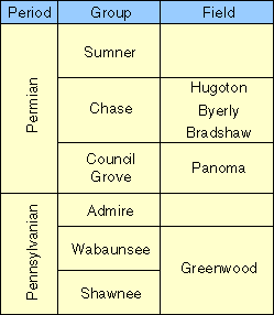
Figure 3--Schematic west-east cross section through the Hugoton natural gas area (modified from Parham & Campbell, 1993).
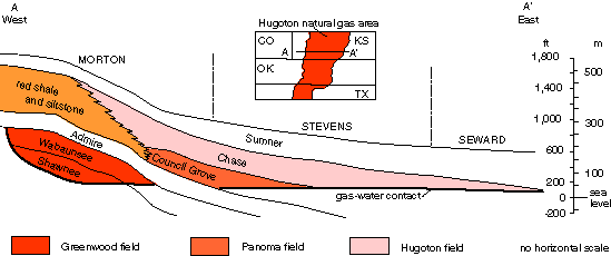
Gas has accumulated in porous reservoir rocks, mostly Permian limestone and dolomite. Figure 3 illustrates a west--east cross section through the Hugoton field. The rocks of the Chase and Council Grove Groups are tilted slightly downward toward the east (and southeast) because of the uplift of the Rocky Mountains to the west. Gas moving from the deeper Anadarko Basin through porous rocks always seeks a higher level (geologists say it moves updip) until it is stopped or trapped. The updip trap on the west and north sides of the field is a stratigraphic--type trap--that is, a trap created by a change in the type of rock. Porous limestones and dolomites interfinger into red shales and siltstones (which were washed eastward from the Rocky Mountain uplift); these shales and siltstones form a barrier that effectively stops the migration of gas. The field is pinched off to the east where the impermeable rocks of the Sumner Group meet the underlying ground water (fig. 3). The top seal is provided by the overlying Sumner Group, a very tight barrier of anhydrite and shale.
Prev. Page--Start of the Report || Next Page--History
Kansas Geological Survey, Geology Extension
Web version Dec. 1996
http://www.kgs.ku.edu/Publications/pic5/pic5_2.html