The High Plains Aquifer
Rex C. Buchanan, B. Brownie Wilson, and James J. Butler, Jr.
Kansas Geological Survey
Public Information Circular 18 - Revised 2023
This document is available as a PDF
Introduction
The High Plains aquifer, which includes the well-known Ogallala aquifer, is the most important water source for much of western and central Kansas (fig. 1), supplying 70% to 80% of the water used by Kansans each day. The majority of water from the High Plains aquifer is used to support irrigated agriculture, but the aquifer’s water is also the primary source of supply for the region’s cities, industry, and rural domestic uses.
However, large-volume pumping from this aquifer has led to steadily declining water levels in the western portion of the region, and the area faces several critical water-related issues. This Public Information Circular describes the High Plains aquifer, the effect of decades of large-volume pumping, and some responses to water issues in western Kansas.
The High Plains Aquifer Defined
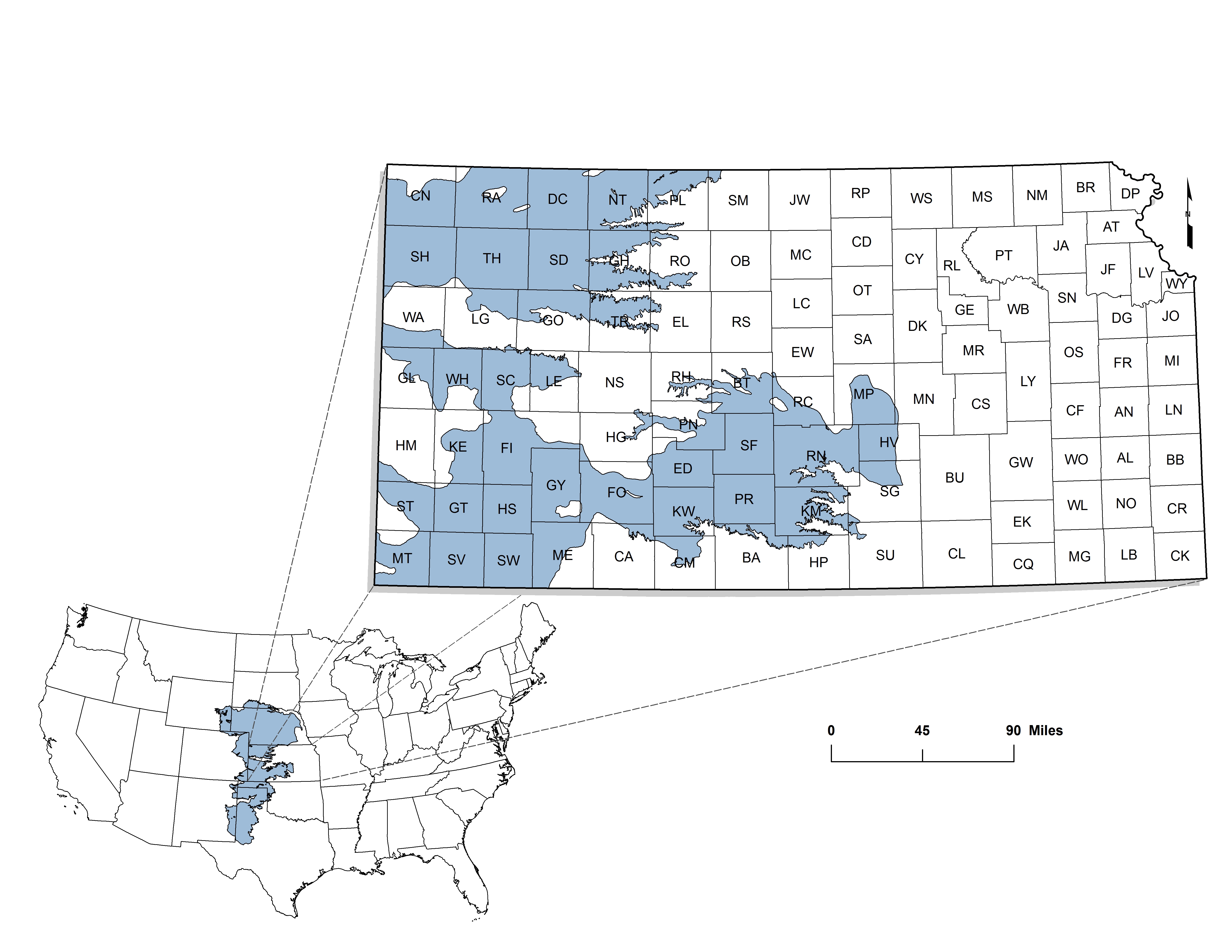
Aquifers are underground deposits of permeable rock or sediments (silts, sands, and gravels) from which water can be pumped in usable quantities. The High Plains aquifer lies beneath parts of eight states in the Great Plains, including about 30,800 square miles of western and central Kansas (fig. 1). It is a regional aquifer system composed of several smaller units that are geologically similar and hydrologically connected—that is, water can move from one aquifer to the other.
Aquifer characteristics are determined in large part by geology. The High Plains aquifer is composed mainly of silt, sand, gravel, and clay—rock debris that washed off the face of the Rocky Mountains and other more local sources over the past several million years. The aquifer varies greatly from place to place: thick in some places, thin in others; permeable (able to transmit water easily) in some places, less so in others. Where the deposits are thick and permeable, water is easily removed and the aquifer can support large volumes of pumping for long periods. In most areas, this water is of good quality.
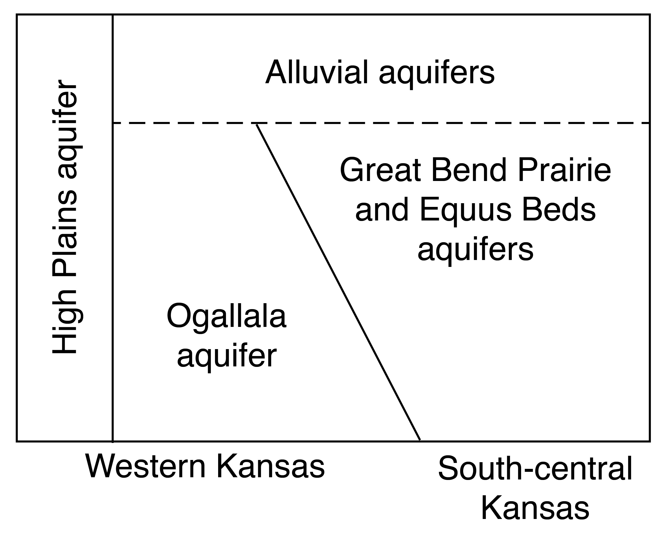
An important component of the High Plains aquifer is the Ogallala aquifer, found generally in the western third of Kansas. In some locations (such as around Lake Scott State Park in Scott County), the Ogallala Formation crops out at the surface, forming a naturally cemented rock layer called mortarbeds. In the subsurface, the Ogallala consists of sands and gravel interlayered with silt and clay beds that are mostly unconsolidated, or not naturally cemented together.
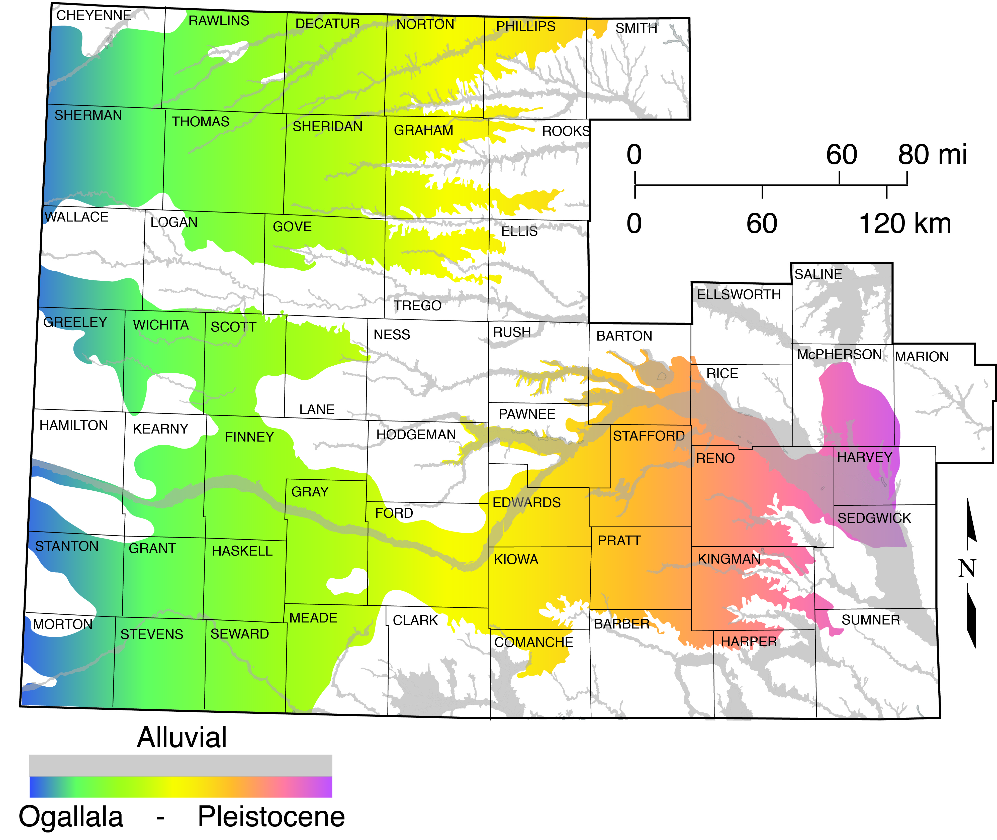
The south-central extension of the High Plains aquifer is composed of younger sediments that are similar to the Ogallala. These younger sediments, deposited during the Pleistocene Epoch, or Ice Ages, include the Equus Beds aquifer (in McPherson, Reno, Harvey, and Sedgwick counties) and the Great Bend Prairie aquifer (in Stafford, Edwards, Pratt, Kiowa, and other counties). Also lying above the Ogallala Formation are other Pleistocene deposits and other younger deposits in the valleys of modern streams. Where these stream deposits (known as alluvium) are connected to the Ogallala or Pleistocene aquifers, the alluvial aquifers are considered part of the High Plains aquifer (fig. 2).
Beneath the High Plains aquifer is much older, consolidated bedrock, usually limestone, sandstone, or shale. In some places, this bedrock yields enough water to a well to be called an aquifer, and it may be connected to the overlying aquifer. Layers of permeable sandstone in the Dakota Formation, for example, are connected to the High Plains aquifer in parts of southwestern and south-central Kansas. Some layers of the underlying bedrock contain saltwater; where these are directly connected to the High Plains aquifer, they pose a threat to water quality.
Water Resources in the High Plains Aquifer
Usable water in the High Plains aquifer is in the very small pore spaces between sediment particles. This water (called groundwater) accumulated slowly—in some of the deeper parts of the aquifer, over tens of thousands of years. Groundwater in the aquifer generally moves from west to east, usually at a very slow rate (tens of feet per year) because of the great amount of friction produced by water moving through the small pore spaces.
Recharge is the natural movement of water into an aquifer, usually from precipitation. Natural recharge to the High Plains aquifer from precipitation is low, in part because much of the rain falls during the growing season, when plant roots intercept the soil moisture. In the semi-arid portions of western Kansas, where precipitation is scant and the water table is relatively deep (a few hundred feet) in many places, most estimates of the long-term average recharge are less than an inch per year. In central Kansas, where the aquifer is closer to the land surface, where soils are sandier, and precipitation amounts greater, recharge can be significant, as much as 4 to 6 inches per year.
Water volumes and use are measured in various ways. One measure is an acre-foot, or the amount of water necessary to cover an acre of ground (a parcel about the size of a football field) with a foot of water. An acre-foot equals 325,851 gallons of water. From 2012 to 2021, a little more than 3 million acre-feet of groundwater was removed from the Kansas High Plains aquifer, of which 2.3 million acre-feet came from the Ogallala aquifer region. Estimated average annual natural recharge to the Ogallala in Kansas is 0.75 million acre-feet.
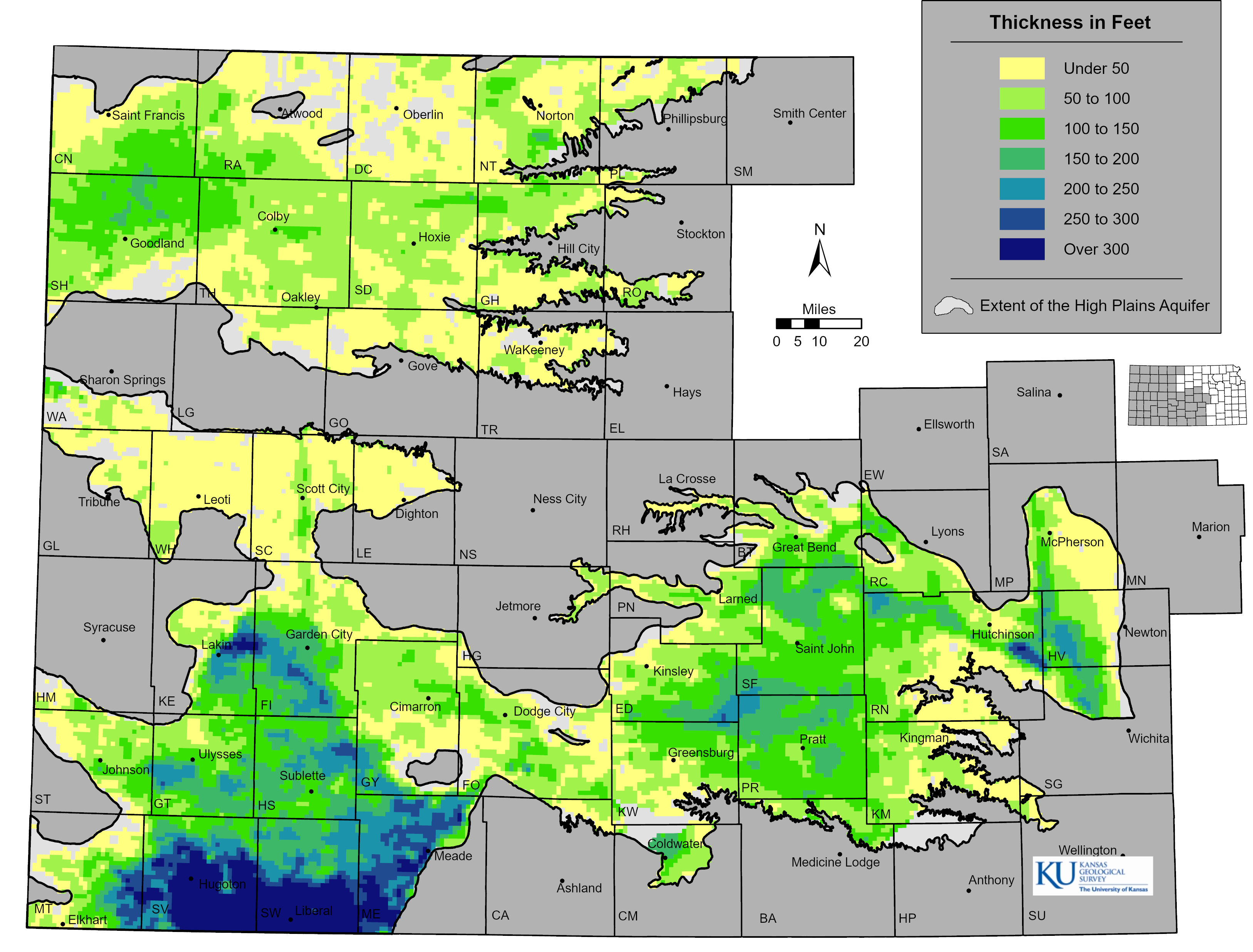
A key aquifer characteristic is its thickness. Aquifer thickness is commonly measured in feet, but that’s not the same as feet of actual water. Only 5–25% of the aquifer volume is pore space that can yield extractable water. In an aquifer with 17% pore space, a 6-foot drop in the water table equates to about a foot of extractable water. In Kansas, the thickness of the High Plains aquifer is generally greatest in the southwestern part of the state (see fig. 3). There, thicknesses of 300 feet and greater were common before the onset of large-scale irrigation, a time that is often called “predevelopment.”
Aquifers also can be characterized by how much water can be removed by a well over short periods. Large volumes of water can be pumped rapidly (1,000 gallons or more per minute) from the High Plains aquifer in many locations. This contrasts with much of the rest of the state, where wells generally produce smaller amounts (less than 100 gallons per minute). By way of comparison, a good household well produces 5 to 10 gallons per minute.
Water-Level Declines in the Aquifer
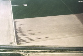
Large-scale irrigation began in western Kansas in the late 1800s, with the use of ditches to divert water from the Arkansas River. As technology improved, groundwater became the major irrigation source because surface water (lakes, rivers, and streams) is relatively scarce in western Kansas. With the advent of large-capacity pumps that were capable of drawing several hundred gallons of water per minute, people began to develop that groundwater. Using a technique called flood irrigation, water was pumped through long pipes or ditches along the edges of a field, then out onto rows of crops (fig. 4A).
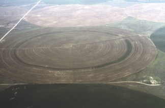
(photos courtesy of Tom Schmiedeler, Washburn University).
In the 1950s and 1960s, technological developments led to a dramatic increase in large-scale pumping. In particular, center-pivot irrigation systems—large sprinklers that roll across the land on wheels—allowed people to irrigate uneven terrain, thus opening up large new areas for irrigation (fig. 4B). These irrigation methods led to the cultivation of crops, such as corn, that could not previously be grown reliably in the area. That grain production led, in turn, to large feedlots and packing plants and a boom in the economy of much of western Kansas, all largely dependent on groundwater. Irrigated corn and wheat in southwest Kansas alone were estimated to contribute more than $900 million to the Kansas economy in 2013 (Roe, 2014, Kansas Department of Agriculture, personal communication).
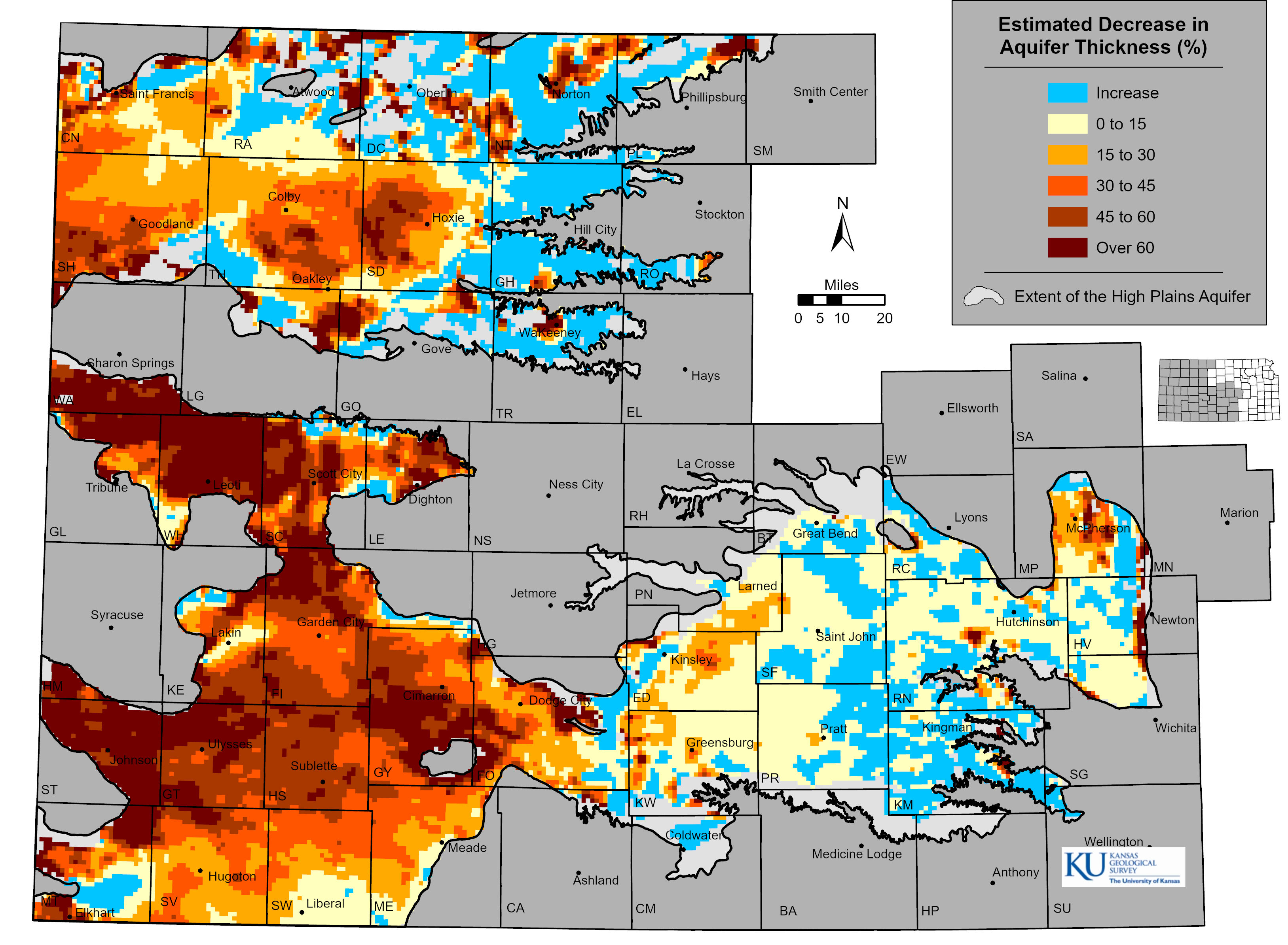
Early on, people believed that the High Plains aquifer contained an inexhaustible amount of water. However, large-volume pumping (mostly for irrigation) eventually led to substantial declines in the water table, and people realized that the amount of water in most locations over the aquifer was finite and could be exhausted. Much of the Ogallala portion of the High Plains aquifer has declined since predevelopment, in some areas by more than 60% (fig. 5).
Nonetheless, in much of the aquifer, considerable amounts of water remain. For example, declines of 100 feet or more have occurred in parts of southwestern Kansas, but that represents less than half of the original aquifer thickness, and 100 to 200 feet (or more) may remain. In contrast, in parts of west-central Kansas—such as Greeley, Wichita, Scott, and northern Finney counties—the original aquifer thickness was much less, often less than 100 feet. In many of these areas, where early flood-irrigation systems were prevalent, less than 30 feet remains.
Will the Aquifer Run Dry?
Perhaps the most common and important question about the High Plains aquifer is how much longer it can support large-scale pumping. It’s a simple question with a complicated answer. First, the aquifer will probably be able to support most small, domestic wells far into the future. With proper planning, most cities and towns should be able to provide for their water needs. Second, the future of agricultural use of the aquifer depends on a variety of factors, including the price of irrigated crops, crop genetics, the price and availability of energy (the deeper the water table, the more energy it takes to pump water), climate, and, most importantly, how the water is managed. Third, the aquifer is not one consistent, homogeneous unit. In places, the aquifer is less than 50 feet in thickness and receives little recharge. In other places, the aquifer is far thicker or receives considerably more recharge.
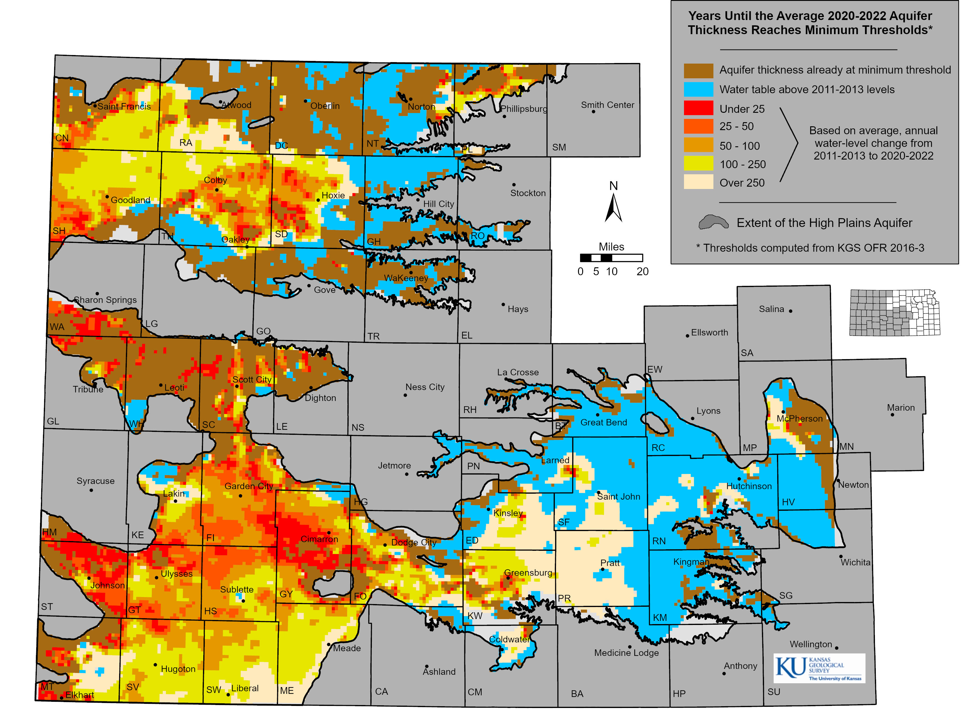
In areas where the aquifer thickness has decreased more than 60% since predevelopment, pumping of groundwater for irrigated agriculture has been severely curtailed as well yields have significantly declined. These areas are likely to be effectively exhausted within the next decade or two unless pumping is reduced to a level more in balance with the amount of groundwater flowing into the area. Projected future climate conditions of higher temperatures and greater evapotranspiration for western and south-central Kansas, coupled with the reduction in the transmissive characteristics in some areas of the aquifer, could exacerbate the problem even in areas that historically have seen little to no changes in aquifer thickness. The Kansas Geological Survey has made simple projections based on past trends in water-level declines to illustrate a possible future for the aquifer. Assuming an aquifer thickness sufficient to support pumping of at least 200 gallons per minute throughout the growing season, these projections can yield a map of the estimated remaining usable lifetime for the aquifer (fig. 6). These estimates, however, are based on past water-level trends and a host of additional assumptions, so they should be considered as an illustration of just one possible aquifer future.
Managing Water in the Aquifer
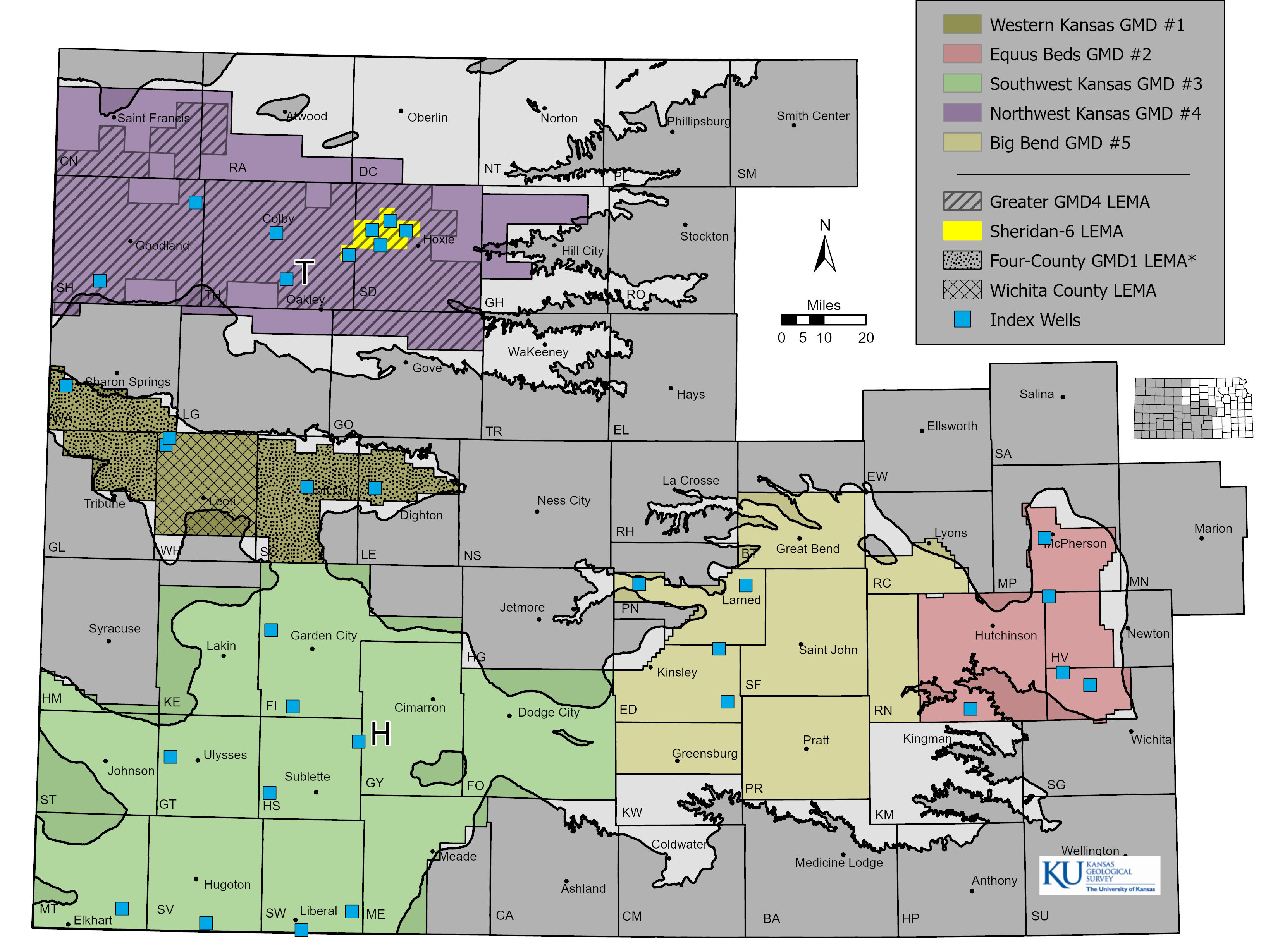
Responsibility for regulating water use in Kansas is spread over several agencies. The Division of Water Resources (DWR) of the Kansas Department of Agriculture (KDA) is responsible for administering water rights and thus is primarily responsible for regulation related to the quantity of water used. Water issues also are subject to local control and management. Five groundwater management districts (GMDs) have been created in Kansas to provide local management within the framework of the state’s water laws. Together, they cover nearly all of the Kansas High Plains aquifer (fig. 7). GMDs, through staff and a board elected by water users, develop and implement policies, rules, and regulations to manage and protect the quantity and quality of water, undertake educational activities, and work with state and federal water-related agencies to regulate and manage the High Plains aquifer.
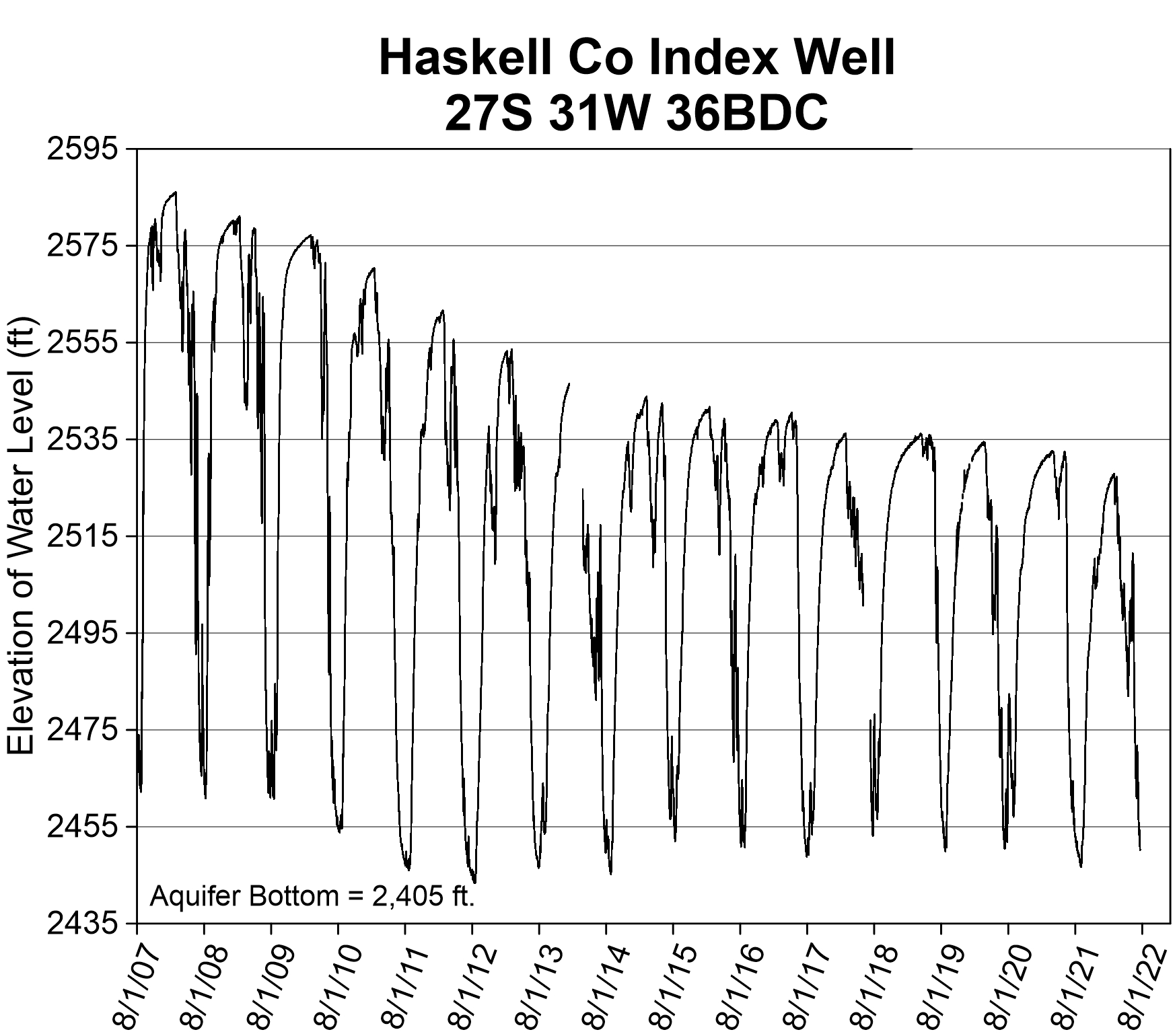
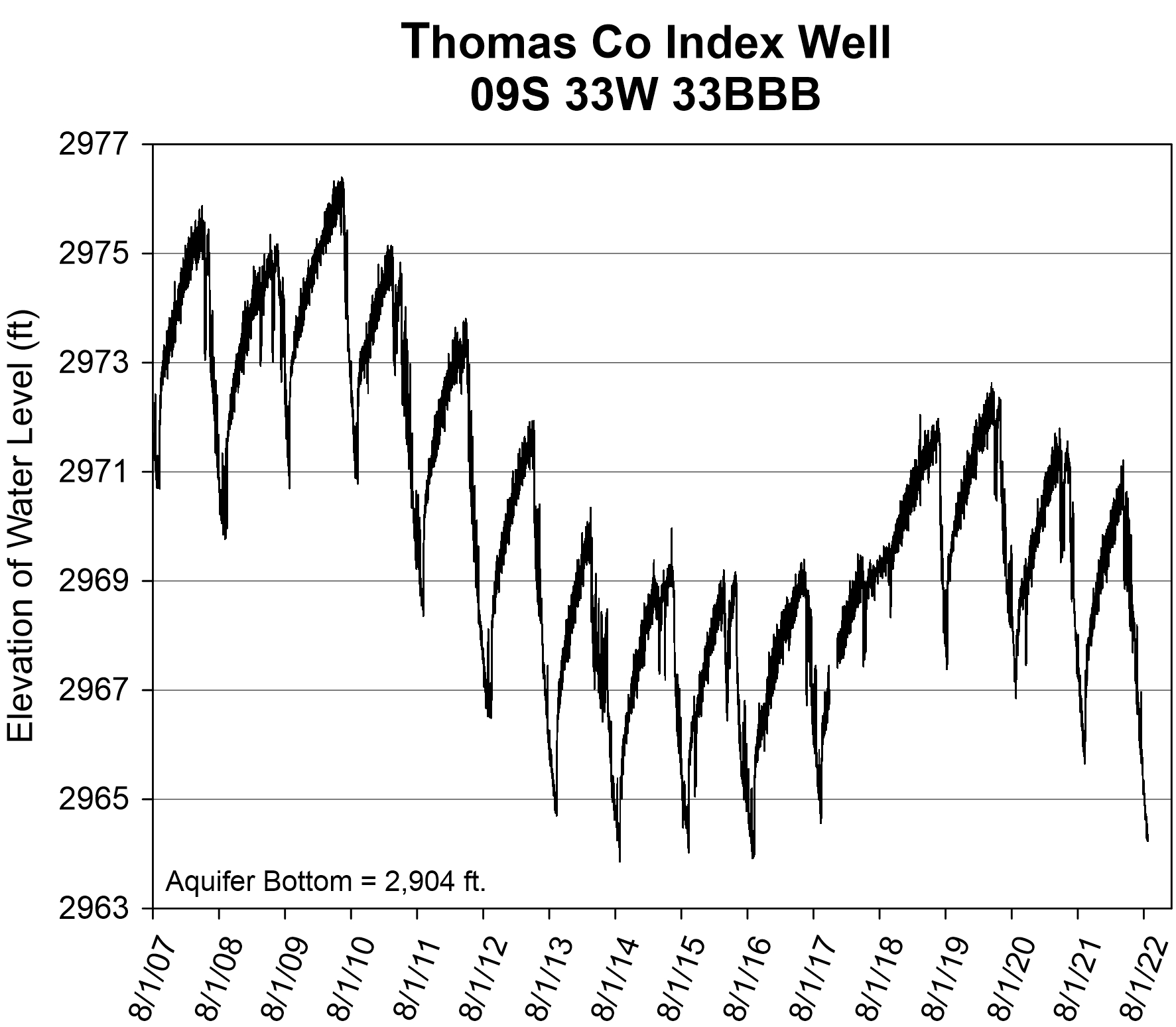
GMDs allow management plans to be tailored to their particular locations and implemented at regional to local levels. To assist in measuring and interpreting the hydrologic responses at this finer scale, the KGS’s Index Well Program, a State Water Plan initiative, currently has 32 continuous water-level recorders located in all five Kansas GMDs (fig. 7). Hydrographs, such as those in fig. 8, show that water-level conditions fluctuate greatly across a calendar year as the aquifer responds to pumping, changes in barometric pressure, and other factors. The elevation of the water level at the Haskell County index well site (H in fig. 7) fluctuates from 80 to more than 120 feet during the growing season (fig. 8) as it drops through a large and significantly less water-bearing clay layer that separates the more transmissive sections of the aquifer. This is an indication that estimated usable lifetime projections (fig. 6) are overly optimistic in this location. The smaller fluctuations since 2014 are due to court-enforced pumping reductions. In comparison, the Thomas County index well site (T in fig. 7) shows remarkable consistency in its responses to pumping and is one of the only index wells in western Kansas in which the annual minimum recorded water-level elevation did not decline every year (fig. 8). The near-steady water levels from 2008 to 2010 and 2015 to 2017 indicate that the groundwater inflow to the area was in near balance with pumping in those years. This suggests that relatively modest reductions in pumping will slow the rates of decline and, in some cases, may stabilize water levels for at least the short term.
Water Quality
The quality of the water of the High Plains aquifer is generally good (total dissolved solids [TDS] of less than 500 mg/l; freshwater is often defined as water with a TDS concentration of less than 1,000 mg/l). Areas of higher TDS concentration are, for the most part, derived from natural sources, although evapotranspiration from surface and near-surface waters and irrigation activities can increase concentrations to much higher than natural levels. An example of this mechanism occurs west of Garden City and north of the Arkansas River, where sulfate and uranium, natural in origin and then concentrated in the river water before infiltrating into the aquifer, have increased to levels of concern. High TDS concentrations in parts of eastern GMD5 and along the Arkansas River valley in GMD2 are derived from saltwater produced by dissolution of salt in the underlying bedrock, whereas small areas of higher TDS concentrations in GMD2 north of the Arkansas River have higher chloride derived from oilfield-brine contamination. High levels of nitrate can be found across the High Plains aquifer; GMDs 2 and 5 are most vulnerable to nitrate contamination because of the shallow depths to water in those areas.
Where Do We Go From Here?
By Kansas law, water is a public resource that is dedicated to the use of the people of the state. Individuals, companies, municipalities, and other entities can obtain permission to use water for beneficial purposes by obtaining a water right, either new or existing. In general, all beneficial uses of water, except most domestic use, require a water right. Kansas water law is based on the doctrine of prior appropriation. That is, when there is insufficient water to meet all water rights, the date of the water right determines who has the right to use the water. This doctrine is commonly expressed as “First in time, first in right.”
In south-central Kansas, the Equus Beds and Big Bend GMDs 2 and 5 manage the aquifer based on safe yield policies where the amount of water appropriated under water rights is equal to or less than the amount of recharge, depending on the effect pumping would have on water quality and minimum streamflows. For example, pumping is limited in areas where it would draw water into the aquifer from a nearby stream and diminish the streamflow below a required minimum rate.
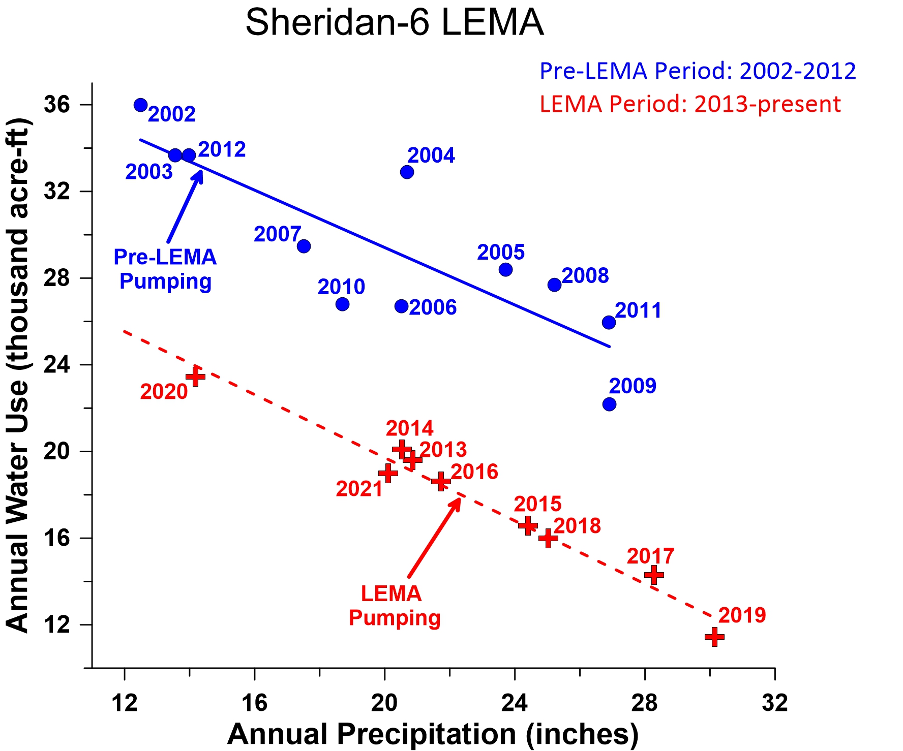
In western Kansas, pumping reductions are the only option currently in place to directly extend the lifespan of the heavily stressed Ogallala aquifer (GMDs 1, 3, and 4). In 2012, legislation was passed to allow a new option, the Local Enhanced Management Area (LEMA), for groundwater management that makes large-scale reductions possible. The key features of LEMA management plans are that they are locally generated within a GMD, have set operational time lines, and are supported by regulatory oversight. The KDA DWR reviews and either approves or rejects the plan but cannot modify it without local authorization. More recently, additional management options (for example, Water Conservation Areas [WCAs]) have been developed to further enhance the prospects for pumping reductions. Four LEMAs have been established in Kansas (fig. 7), the first of which was set up in 2013 in a 99-square-mile area of Sheridan and Thomas counties in GMD4 (Sheridan-6 LEMA). Here, local water right holders voluntarily agreed to reduce their water usage by 20% (reassessed every five years) with the hope of slowing groundwater declines and extending the life of the aquifer. In the first nine years of the LEMA and controlling for climatic conditions, water use decreased by approximately 30% (fig. 9) and the groundwater decline rate decreased by about 58%. Preliminary economic analyses indicate this was done without affecting producer incomes.
•
The authors thank Bob Buddemeier, Bob Sawin, Don Whittemore, and Dave Young, all formerly of the Kansas Geological Survey, for their help in the preparation of this circular.
Websites
Kansas Geological Survey
• Information about water levels in
specific wells is available at
http://www.kgs.ku.edu/Magellan/WaterLevels—annual well measurements
http://www.kgs.ku.edu/HighPlains/OHP/index_program/index.shtml
—near real-time data
• More information about the High
Plains Aquifer is available at
http://www.kgs.ku.edu/HighPlains/index.shtml
and https://www.kgs.ku.edu/HighPlains/HPA_Atlas/index.html
Kansas Water Office
Groundwater Management Districts
https://www.kgs.ku.edu/Hydro/gmd.html
Additional reading
Bessire, L., 2021, Running Out—In Search of Water on the High Plains: Princeton University Press, 264 p.
Griggs, B. W., 2014, Beyond drought: Water rights in the age of permanent depletion: University of Kansas Law Review, v. 62, p. 1,263–1,324. https://doi.org/10.17161/1808.20269
Whittemore, D. O., Butler, J. J., Jr., and Wilson, B. B., 2018, Status of the High Plains aquifer in Kansas: Kansas Geological Survey Technical Series 22, 14 p. https://www.kgs.ku.edu/Publications/Bulletins/TS22/index.html