Kansas Geological Survey, Public Information Circular (PIC) 13
Prev. Page--Start of PIC || Next Page--Causes of Landslides
![]()
![]()
![]()
![]()
Kansas Geological Survey, Public Information Circular (PIC) 13
Prev. Page--Start of PIC ||
Next Page--Causes of Landslides
A landslide is the downhill movement of masses of soil and rock by gravity. Soil, as defined by civil engineers, is the loose material between the ground surface and the underlying bedrock. Landslides come in many forms. Rock falls occur along cliffs and outcrops where blocks of rock break off and fall down the slope. Block slides and slumps occur where blocks or masses of intact soil or rock move downslope along a failure surface. Block slides have straight failure surfaces, and the motion is analogous to a box (the landslide mass) sliding down a ramp (the failure surface). Slumps, on the other hand, have concave failure surfaces. As the landslide mass moves along this curved surface, it rotates and tilts trees and other objects so that they point uphill. Earth flows (fig. 2) are landslides in soil in which the landslide mass breaks apart instead of remaining relatively intact as in a slump or block slide. The motion in an earth flow is analogous to a thick mixture of soil and water oozing down the slope. Creep is the slow, imperceptible downslope movement of soil and rock. Because creep rarely fractures the ground surface, other evidence such as tilted trees, telephone poles, or walls must be used to identify affected areas. Creep is widespread on hillsides throughout Kansas.
Figure 2--An earth flow near Interstate Highway 70, Ellsworth County. The head is the upslope portion of the landslide. The scarp, the steeply inclined failure surface with exposed soil and rock, marks the top of a landslide. The toe is the downslope portion of the landslide. A mound of soil called a lobe marks the toe of the landslide.
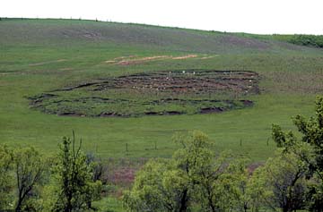
Scarps, tension gashes, and lobes are features that identify active or recently active landslides (fig. 2). A scarp is a steep (nearly vertical) region of exposed soil and rock at the head of the landslide where the failure surface ruptures the ground surface. Tension gashes are breaks in the ground surface that are oriented parallel to the scarp and are found throughout the landslide mass. Lobes are bulges in the ground surface where the landslide mass mounds up at the toe of the landslide. With time, tension gashes fill with soil, the scarp erodes back, and vegetation covers the surface muting the features of the landslide. Old landslides can be recognized by the irregular, bulging ground surface that remains long after other features have vanished.
Damage to human-made structures can be another indicator of landslide activity. Sidewalks and roads out of alignment, retaining walls that lean downslope, broken utility lines, cracked foundations and walls, and doors and windows out of plumb are examples of such structural damage. However, this damage is not necessarily due to landslides. Other geologic hazards, including subsidence and expansive soil, can cause similar structural damage.
Prev. Page--Start of PIC || Next Page--Causes of Landslides
Glossary || Additional Reading and Internet Sites
Kansas Geological Survey, Public Outreach
Web version April 1999
http://www.kgs.ku.edu/Publications/pic13/pic13_2.htm