
Kansas Geological Survey, Open-file Report 1991-48
Surficial Geology of Butler County, Kansas, Final Report
by
James S. Aber
Earth Science Department, Emporia State University
KGS Open-file Report 1991-48
April 26, 1991
Introduction
Detailed, large-scale geologic mapping for all of Butler County has not been undertaken before. This project was initiated in 1989 as part of the Kansas Geological Survey's program to update and improve county geological mapping of the state. Butler County is the largest county in the state of Kansas; the county includes 35 whole townships and 7 partial townships. Butler County is located in south-central Kansas and is almost wholly contained within the Flint Hills physiographic province.
Geological mapping of Butler County was done on 7 1/2-minute quadrangle topographic base maps at a scale of 1:24,000. Butler County is covered by 16 whole quadrangles and 20 partial quadrangles (Fig. 1). Geologic mapping was done primarily through field observation and interpretation of aerial photographs. The Soil survey of Butler County, Kansas (Penner et al. 1975) was consulted as well as existing geologic maps (Jewett 1964, Kellogg 1978).
Fig. 1 General location map for Butler County and index map for 1:24,000-scale topographic maps that cover Butler County.
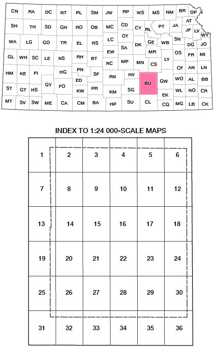
| 1. Elbing, 1957 (1978 photorevised) | 19. Andover, 1961 (1975 photorevised) |
| 2. Peabody Southeast, 1962 | 20. Santa Fe Lake, 1955 (1970 photorevised) |
| 3. Burns, 1962 | 21. Augusta, 1961 (1979 photorevised) |
| 4. Florence Southeast, 1962 | 22. Leon, 1963 (1979 photorevised) |
| 5. Cassoday, 1967 | 23. Keighley, 1964 (1979 photorevised) |
| 6. Matfield Green Southeast, 1967 | 24. Beaumont, 1964 |
| 7. Whitewater, 1962 (1978 photorevised) | 25. Rose Hill, 1960 (1970 photorevised) |
| 8. Potwin, 1961 | 26. Douglass, 1955 (1970 photorevised) |
| 9. El Dorado Northwest, 1961 | 27. Gordon, 1961 (1979 photorevised) |
| 10. De Graff, 1961 | 28. Augusta Southeast, 1964 (1979 photorevised) |
| 11. Rosalia Northwest, 1961 | 29. Latham, 1964 (1979 photorevised) |
| 12. Rosalia Northeast, 1961 | 30. Latham Southeast, 1964 |
| 13. Greenwich, 1960 (1970 photorevised) | 31. Mulvane, 1955 |
| 14. Benton, 1955 (1970 photorevised) | 32. Udall, 1955 |
| 15. El Dorado Southwewst, 1961 (1979 photorevised) | 33. Wilmot, 1965 |
| 16. El Dorado, 1961 (1979 photorevised) | 34. Atlanta, 1964 |
| 17. Pontiac, 1961 | 35. Cambridge Northwest, 1964 |
| 18. Rosalia, 1961 | 35. Cambridge Northwest, 1964 |
Previous Geological Mapping
Butler County became an important petroleum production and refining center early in this century following the initial discovery of gas near Augusta (1906) and later discovery of the giant El Dorado oil field in 1915. As a result of this economic development, detailed surface and subsurface geological mapping was carried out in the El Dorado vicinity by Fath (1921). Fath's maps (1:31,680) demonstrate the remarkable structural complexity of surficial bedrock in the area. These maps were an important source of information for constructing the current map.
The surficial geology of Butler County was shown on the Geologic map of Kansas (Jewett 1964) at a small scale (1:500,000) with few details. This map of Butler County was based on limited reconnaissance-style field work that was done before large-scale topographic maps were available as a base. Kellogg (1978) prepared the first medium-scale (about 1:94,000) map covering all of Butler County. This map included some improvements, but generally it repeated most of the features that are shown for Butler County on the state map. O'Conner et al. (1982) prepared a large-scale (1:50,000) map of the southwestern portion of Butler County; however, this map was little more than an enlargement of the existing state map (Jewett 1964).
In all of these previous maps, primary emphasis was placed on bedrock geology. Unconsolidated alluvial sediment was shown only in larger river valleys, and small patches of loess were indicated in western portions of the county. Widespread chert gravel alluvium in uplands was not shown, nor was any attempt made to separate different alluvial surfaces within valleys.
Map Units
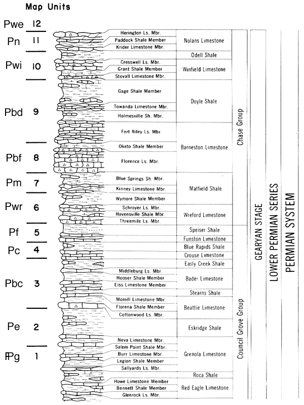
Bedrock and unconsolidated sediment of Butler County were divided into 15 major map units: units 1-12 are bedrock and units 13-15 are unconsolidated sediments (Table 1). These units can be recognized and traced over large areas of the county. In addition, three units (9, 12 and 14) have local subdivisions. Bedrock units include portions of the Council Grove, Chase, and Sumner Groups (Fig. 2).
Table 1. Summary of stratigraphic map units and map colors for Butler County.
| Map Label |
No. | Stratigraphic Interval | Color |
|---|---|---|---|
| Ql | 15. | base Goessel soil/loess, mapping thickness >5 feet |
brown |
| Qal | 14. | base Quaternary alluvium, average mapping thickness >10 feet |
yellow |
| Qt | 14t. | base Quaternary terrace alluvium, position >10 feet above unit 14 |
yellow orange |
| Tg | 13. | base Olpe soil/Neogene alluvium, average mapping thickness 5 feet |
orange |
| (red line) |
12h. | base Hollenberg Ls, marker bed in unit 12 (no thickness) |
(none) |
| Pwe | 12. | base Wellington Fm, average mapping thickness >30 feet |
(blank) |
| Pn | 11. | base Nolands Ls to top Herington Ls, average mapping thickness 30 feet |
aquamarine |
| Pwi | 10. | base Winfield Ls to top Odell Sh, average mapping thickness 40 feet |
lavender |
| (hatchured) | 9s. | zones of numerous sinkholes within Ft. Riley outcrop region (no thickness) |
gray |
| Pbd | 9. | base Ft. Riley Ls to top Gage Sh, average mapping thickness 100-120 feet |
(blank) |
| Pbf | 8. | base Barneston Ls to top Oketo Sh, average mapping thickness 30 feet |
pink |
| Pm | 7. | base Kinney Ls to top Blue Springs Sh, average mapping thickness 30 feet |
greenish blue |
| Pwr | 6. | base Wreford Ls to top Wymore Sh, average mapping thickness 50 feet |
(blank) |
| Pf | 5. | base Funston Ls to top Speiser Sh, average mapping thickness 30 feet |
red |
| Pc | 4. | base Crouse Ls to top Blue Rapids Sh, average mapping thickness 30 feet |
green |
| Pbe | 3. | base Beattie Ls to top Easly Creek Sh, average mapping thickness 60 feet |
(blank) |
| Pe | 2. | base Neva Ls to top Eskridge Sh, average mapping thickness 30 feet |
magneta |
| 1. | below Neva Ls, average mapping thickness >30 feet |
(blank) | |
| L. | El Dorado Lake, elevation approximately 1340 ft |
purple |
Fig. 2 Standard stratigraphic column for Lower Permian units of the Council Grove and Chase Groups in southern Kansas. Wellington Formation (unit 12) of the Sumnber Group overlies the Nolands Limestone. Adapted from Lutz-Garihan and Cuffey (1979, fig. 3).
Bedrock map units:
The formal bedrock stratigraphy has been adequately defined and described by Zeller (1968) and Kellogg (1978), to which the reader is referred for detailed descriptions of lithology and thickness for individual units. Bedrock map units were chosen for ease of identification and tracing in the field; therefore, map unit boundaries do not coincide in all cases with formation boundaries. Bedrock map units are generally marked by a distinctive limestone unit at the base, which is overlain by a shale unit. The thinnest bedrock map unit is about 30 feet thick.
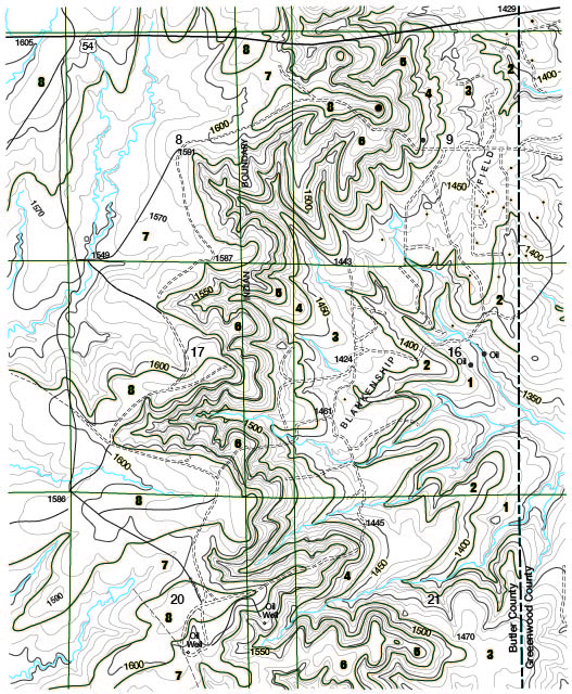
The Council Grove Group is found exclusively in easternmost Butler County, where it crops out in the lower portion of the Flint Hills escarpment (Fig. 3). The Chase Group forms the crest of the Flint Hills escarpment. The outcrop patterns of bedrock units along the Flint Hills escarpment are extremely intricate, and many small erosional outliers of resistant bedrock units are present along the crest of the escarpment.
Fig. 3 Portion of Rosalia topographic quadrangle showing map pattern of bedrock units 1-8 (see Table 1). Crest of the Flint Hills escarpment exceeds 1600 feet elevation and forms the drainage divide between the Walnut River basin (west) and Fall River basin (east).
The Florence Limestone (unit 8) forms the resistant cap along much of the escarpment. However, in the southeastern part of the county the Florence has been removed by erosion, and the Wreford Limestone (unit 6) forms the escarpment. Residual chert from the Florence often draps over underlying Blue Springs Shale down hillsides to the Kinney Limestone. For this reason, the Kinney has been mistaken for the base of the Florence Limestone in many places on previous maps.
The Chase Group underlies most of Butler County west of the Flint Hills escarpment. Although the landscape is generally less rugged, intricate outcrop patterns have resulted from stream dissection, and small outliers of resistant bedrock units form buttelike hills (Fig. 4). The Wellington Formation (unit 12) of the Sumner Group is present only in western Butler County. Proposals to relocate the Permian/Pennsylvanian boundary upward would not affect any of the bedrock map units. In fact, the base of the Neva Limestone (unit 2) has been proposed as the new boundary (Baars and Maples 1990).
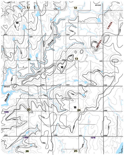
Fig. 4 Portion of Gordon topographic quadrangle showing outcrop pattern of the Winfield Limestone (unit 10). Note general dip to west and buttelike erosional outliers of Winfield Limestone.
Soils and unconsolidated sediments:
Soils are in general not suitable for mapping of bedrock geology in Butler County. However, some soils were found useful as indicators for unconsolidated sediment of mappable thickness. Unconsolidated sediments were mapped where they are greater than 3 to 5 feet thick and are relatively continuous over bedrock. These soils and corresponding map units are summarized below based on Penner et al. (1975):
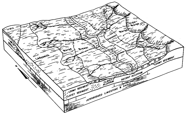
1. Olpe Series: Parent material consists of alluvial chert gravel, 3-8 feet thick, with locally interbedded sand and clay of the Norge Series. Located along high terraces and hill tops in southern portion of county (Fig. 5). Hill-top gravels display strong oxidation and clay enrichment in B horizons, whereas high-terrace gravels are less strongly oxidized in B horizons. Olpe-Norge complex was mapped as alluvium of presumed Neogene age (unit 13).
Note: Florence soil represents residual chert accumulations and was not separately mapped from bedrock. It is a good indicator for the Florence Limestone, where not covered by loess soils.
2. Verdigris Series: Parent material consists of silt and clay alluvium greater than 5 feet thick in modern valleys. Covers level bottom lands and floodplains. Associated with Brewer, Osage, and Vanoss soils (Fig. 5). These soils were mapped as alluvium (unit 14), which is assumed to be Quaternary, probably late Pleistocene and Holocene in age.
Note: Low terraces, 10-20 feet above floodplain, are covered by Irwin, Ladysmith, or Norge soils (Fig. 5). These terrace surfaces are thus at least as old as the loess soil cover and may be late or middle Pleistocene in age. Such terraces were mapped, as unit 14t, only where they are morphologically distinct from lower alluvium.
3. Goessel Series: Parent material consists of sandy, silty, clay >5 feet deep on nearly level to gently sloping uplands in western portions of county. May include small pockets of Rosehill soil. Goessel soils represent loess >5 feet thick and are mapped as unit 15. The loess is assumed to be Quaternary, probably late Pleistocene or Holocene in age.
Note: many other upland soils have a significant loess component, including Rosehill, Dwight, Irwin, Ladysmith, and Labette soils. However, these soils are underlain by weathered bedrock in the 3-5 foot range. Unaltered loess parent material is generally not present and was not including in mapping. These soils are not reliable indicators for particular bedrock map units, as they may be present over limestone, cherty limestone, shale, or alluvium.
Figure 5. Typical soils associated with alluvial deposits in Butler County, Kansas. Note Olpe-Norge soil on high terrace, Norge, Ladysmith and Irwin soils on low terrace, and Verdigris, Brewer and Vanoss soils on valley bottom. Taken from Penner et al. (1975, fig. 3).
Lower Permian Cyclothems
To aid in recognizing and mapping Lower Permian bedrock units, a general cyclothem model was developed for Butler County (Fig. 6). The cyclothem model includes six units, from the top down (based in part on Moore 1964 and Kellogg 1978):
6. Limestone: tan to gray, platy to massive, fossiliferous limestone, chalky limestone, or dolomitic limestone; cross bedding, oolites, and ripple marks common; locally cherty toward base with algal bed toward top; diverse fossils. Examples: Morrill, Funston, Schroyer, Fort Riley, Cresswell, Herington. Environment: offshore regressive sea to shallow, high-salinity, lagoon.
5. Shale: gray or green, fissile to platy, calcareous, fossiliferous shale or shaly limestone; diverse fossils including trilobites. Examples: Florena, Havensville. Environment: farthest offshore sea of maximum transgression.
4. Cherty limestone: tan or light gray, platy to massive, fossiliferous limestone or chalky limestone; scarce to abundant nodules or beds of chert; locally may display algal banding or cross bedding; diverse fossils including many echinoids and fusulimds. Examples: Neva, Cottonwood, Crouse, Threemile, Florence, Stovall. Environment: far offshore, shallow sea of near-maximum transgression.
3. Shale: gray, tan or green, platy, fossiliferous, calcareous shale and shaly limestone; abundant brachiopod and mollusk fossils. Examples: upper Eskridge, upper Easly Creek, upper Speiser, upper Wymore, upper Gage. Environment: shallow, normal salinity, transgressive sea.
2. Limestone: one or more, thin, gray or tan, chalky or coquina, fossiliferous limestones; abundant brachiopods and mollusks. Examples: middle Eskridge, middle Speiser. Environment: shallow to estuarine, low-salinity, transgressive sea.
1. Shale: platy, somewhat calcareous, maroon or red shale above green and black shale; generally few fossils, black shale has inarticulate brachiopods, maroon shale lacks marine fossils. Examples: lower Eskridge, lower Speiser, lower Wymore, lower Gage. Environment: lagoon or estuarine (green or black) to emergent (maroon) tidal flat or sabhka.
Figure 6. Ideal major and minor cyclothems for Council Grove and Chase Groups, Lower Permian, Butler County, Kansas.
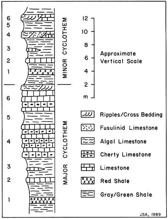
Major cyclothems are 50-100 feet (15-30 m) thick and include thick, cherty limestone units (Fig. 6). The Speiser/Wreford and Blue Springs/Barneston cyclothems are typical examples. Minor cyclothems are usually only 25-40 feet (8-12 m) thick; thin limestones of variable lithology are typical. Good examples include the Eskridge/Beattie, Easly Creek/Crouse, Blue Rapids/Funston, Wymore/Kinney, Gage/Winfield, and Odell/Nolands cyclothems.
The bedrock stratigraphy has remarkable lateral consistency; unit thicknesses vary little and only a few noticeable facies changes are present. Unit thicknesses are generally greatest in the northern and eastern portions of the county. Slight thinning of bedrock strata occurs in the central and southwestern portion of the county over the crest of the Nemaha Uplift.
Many limestone units show evidence of deposition in very shallow water across the central portion of the county. Typical sedimentary structures include cross bedding, ripple marks, oolites, and algal laminations. Such features are present in limestone units from the Cottonwood up through the Fort Riley. This region is part of what Imbrie et al. (1964) named the "Greenwood Shoal" of the early Permian sea.
Water depth probably did not much exceed wave base during deposition of minor cyclothems. The absence of black shale from the core position (unit 5) of major cyclothems also suggests that deep water conditions were not achieved during major marine transgressions. The total range of relative sea-level change between exposed sabhka stage (unit 1) and maximum transgression (unit 5) was probably 100 feet (30 m) or less (McCrone 1964).
Lower Permian cyclothems are similar to Upper Pennsylvanian cyclothems of eastern Kansas (Klein and Willard 1989); each cyclothem includes a triad of limestone-shale-limestone (units 4, 5 and 6) and represents mainly marine sedimentation. Lithologies of individual units within Lower Permian cyclothems differ considerably, however, from Upper Pennsylvanian cyclothems. Red beds, cherty limestone, and evaporites (subsurface) are common in Lower Permian strata; whereas coal, sandstone, and black shale are scarce to absent.
The lithologic differences between Upper Pennsylvanian and Lower Permian cyclothems are thought to reflect: (1) increasing aridity of the climate, (2) decreasing supply of clastic sediment, and (3) decreasing amplitude of transgressive/regressive cycles during early Permian time.
Many explanations for Pennsylvanian and Permian cyclothems of the midcontinent have been proposed. These explanations generally fall into three categories: crustal movements, glacio-eustatic sea-level changes, and delta-lobe shifting. The Lower Permian cyclothems of Butler County do not contain features associated with deltaic sedimentation, and the remarkable lateral consistency of units argues against significant local crustal movements during the early Permian (Moore 1964). The only reasonable explanation for repeated marine transgressions and regressions is glacioeustasy related to glaciation in Gondwana.
Structural Features
Bedrock dip is normally westward at 20 to 40 feet per mile, but this varies in many areas. Northward, southward, and eastward dips as steep as 60 to 80 feet per mile are commonly developed in association with structural anticlines and synclines. Dip angle may locally be as great as 10° in these situations.
Structural features mapped or measured in surface rock outcrops include anticlines, synclines, joints, and faults. Only those features that are visible at the surface have been mapped. Many subsurface structures are known from intensive oil-well drilling, but structures that do not have clear surface expression are not included in this map.
Basement control of structures in sedimentary bedrock of the midcontinent was recognized long ago by Fath (1921, p. 149), who stated that these structures are "in large part the surface expression of deep-seated readjustments along ancient faults or lines of weakness present in the pre-Cambrian basement rocks of the region." Many, but not all, of the surficial bedrock structures of Butler County are related to basement tectonics.
Anticlines and synclines:
Anticlines and synclines are mapped only where a reversal in dip can be documented from surface outcrop patterns and elevations. In other words, opposite flanks of anticlines or synclines must dip in opposite directions. Subtle flexures are not indicated as anticlines or synclines, where the direction of dip is the same on both limbs. In most cases, anticlines and synclines occur in closely matched pairs, but this is not true in all situations. A total of 23 anticlines and synclines with surface expression were mapped for Butler County (see Fig. 7 and Table 2).
Figure 7. Anticlines, synclines, and faults in surficial bedrock of Butler County, Kansas. Many anticlines and synclines are arrayed in curved, en echelon patterns over the crest of the Nemaha Uplift immediately west of the buried Humboldt Fault zone.
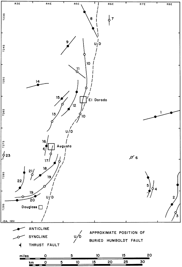
Table 2. Surficial anticlines and synclines of Butler County, Kansas. See Figure 7 for locations; *indicates newly named or described structure.
| Structure | Associated Oil Field or River |
|---|---|
| 1. Blankinship Anticline | Blankinship, Young |
| 2. Beaumont Anticline | Ferret, Ferrel South, Shinn, Shinn NE, Wehrman |
| 3. Grouse Syncline* | Grouse Creek |
| 4. Latham Syncline* | none |
| 5. Brant Anticline | Brant-Sensenbaugh |
| 6. Eagle Syncline* | Eagle Creek |
| 7. Cole Syncline* | Cole Creek |
| 8. Burns Dome | oil field |
| 9. DeGraff Anticline* | none |
| 10. Walnut Syncline | Walnut River and West Branch Walnut River |
| 11. Dunkle Syncline | unnamed stream |
| 12. El Dorado Anticline | El Dorado |
| 13. Hammond-Fowler Syncline | none |
| 14. Pierce Anticline | Pierce |
| 15. Shumway Anticline | El Dorado |
| 16. Augusta North Anticline | Augusta North |
| 17. Augusta Syncline | Walnut River |
| 18. Augusta South Anticline | Augusta |
| 19. Gordon Syncline* | none |
| 20. Douglass Anticline* | oil field |
| 21. Salter Syncline* | none |
| 22. Rose Hill Anticline* | oil field |
| 23. Seltzer Syncline* | Seltzer Spring |
The crest and trough of a paired anticiine/syncline are generally parallel to each other with the syncline located from 1 to 2 miles east of the anticline (Fig. 7). Between the anticline and syncline, bedrock dips toward the east. The fold pair may extend for several miles in northerly to northeasterly trends. The two longest folds are both synclines: Walnut Syncline (10) and Gordon Syncline (19). Most of the anticlines and some of the synclines are known from previous mapping (Fath 1921, Kellogg 1978). However, several synclines and a few anticlines have never been described before. Syncline troughs coincide in many places with stream valleys (Fig. 8).
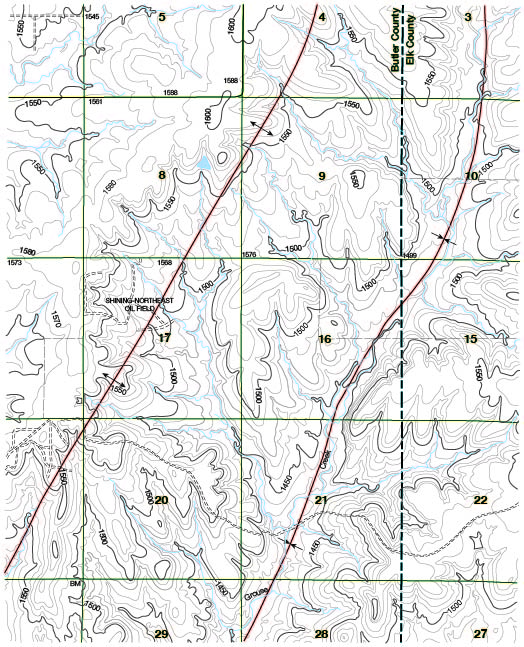
Figure 8. Portion of the Latham SE topographic quadrangle. Grouse Creek follows a syncline trough, and the anticline crest to the west is breached in several places by small tributary streams. Map slightly reduced from original 1:24,000 scale.
Fath (1921) demonstrated the structural complexity of the El Dorado Oil Field vicinity. That complexity is reaffirmed by surface mapping of bedrock outcrop patterns. At least three local culminations (Chesney, Oil City, and Boyer Domes) are developed on the El Dorado Anticline, and several secondary anticlines and synclines are present to the north and west. An equally complex structural pattern is present in the region between Augusta and Douglass (Fig. 7).
Surficial folds of Butler County are located above major uplifts in the basement surface. Folds in the western portion of the county are associated with the Nemaha Uplift, which is bounded on its east side by the buried Humboldt Fault. The basement surface is offset by several 100 feet to more than 1000 feet along the fault zone (Bickford et al. 1979). Local culminations on the Nemaha Uplift correspond to the Burns, El Dorado, and Augusta-Douglass regions of surficial folding. Surficial folds in the southeastern portion of Butler County are located above a more subtle uplift in the basement surface.
Faults:
Only one surficial fault was identified in Butler County. A thrust fault is located on the western flank of the North Augusta Anticline. The fault is exposed near the west end of a road cut on the north side of US highway 54-77, approximately 1 mile west of Augusta (SW SW sec. 21, T. 27 S., R. 4 E.). The fault cuts through the Ft. Riley Formation, which here strikes/dips 340°/10° SW. The thrust fault strikes/dips 350°/20° SW and has an estimated throw of 20 feet. This site displays the greatest amount of structural disturbance seen at the surface anywhere in Butler County.
Joints:
Joints are ubiquitous in bedrock of Butler County, although accurate measurements of joint strikes can only be made where good horizontal exposures in limestone are present. Joint trends have been measured at 21 sites; measurements were taken in 5° intervals (Tables 3 and 4; Fig. 9). At most sites, two sets of joints are present, some sites have three joint sets, a few sites have only one set of visible joints.
Figure 9. Rose diagram of joint strike orientation for Butler County, Kansas. Joints are grouped by 10° intervals; scale indicates number of sites with joints in each interval.
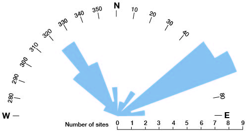
These results are similar to those obtained by Ward (1968) and White (1990). The two dominant joint sets (1 and 2) are complementary (around 90° angle) and are present at most sites. Three minor joint sets (3-5) are each found at less then one-quarter of sites.
Joints sets 2 and 3 are related to well-known basement structures. Joint set 2 (310-335°) is parallel to numerous northwest-trending basement faults found throughout eastern Kansas. Joint set 3 (15-35°) corresponds to the north-northeast trend of the Humboldt Fault zone on the east side of the Nemaha Uplift. Joint set 1 (50-65°) is found throughout Butler County, but it is not obviously related to any known basement structures, nor are the other two minor joint sets associated with known basement features.
Table 3. Summary of joint measurements from Butler County. All joints are vertical (except as noted).
| Quadrangle | Location | Rock Unit | Joint Strike |
|---|---|---|---|
| Latham SE | SW sec. 9, T. 29 S., R. 8 E. | Crouse | 50-55° |
| Latham SE | SW sec. 20, T. 29 S., R. 8 E. | Crouse | 50-55° |
| Latham | NW sec. 8, T. 29 S., R. 7 E. | Kinney | 60°, 335° |
| Keighley | SW sec. 17, T. 27 S., R. 7 E. | Florence | 65°, 340°, 310° |
| Keighley | NW sec. 22, T. 27 S., R. 7 E. | Florence | 60°, 330° |
| Cassoday | NW sec. 15, T. 23 S., R. 7 E. | Ft. Riley | 60°, 310-20° |
| Cassoday | SE sec. 18, T. 23 S., R. 7 E. | Ft. Riley | 60°, 320° |
| Rosalia NW | NE sec. 30, T. 24 S., R. 7 E. | Ft. Riley | 50°, 320° |
| Rosalia NW | SW sec. 12, T. 25 S., R. 6 E. | Ft. Riley | 60°, 310° |
| El Dorado | NE sec. 14, T. 26 S., R. 5 E. | Ft. Riley | 30°, 50° |
| El Dorado SW | C sec. 21, T. 25 S., R. 5 E. | Ft. Riley | 15°, 350°, 330° |
| Augusta | SW sec. 15, T. 27 S., R. 4 E. | Ft. Riley | 60°, 325°, 25° |
| WiImot | NE sec. 15, T. 30 S., R. 4 E. | Ft. Riley | 80°, 320° |
| Santa Fe | SW sec. 21, T. 27 S., R. 4 E. | Ft. Riley | 55° (dip 82° SE) |
| Douglass | NE sec. 30, T. 28 S., R. 4 E. | Ft. Riley | 55-60°, 325-330° |
| Douglass | NE sec. 19, T. 28 S., R. 4 E. | Ft. Riley | 50-55°, 290° |
| De Graff | NW sec. 18, T. 25 S., R. 6 E. | Winfield | 55°, 315° |
| Peabody SE | SW sec. 25, T. 23 S., R. 3 E. | Nolands | 75°, 350° |
| Potwin | SW sec. 8, T. 24 S., R. 4 E. | Nolands | 60°, 35°, 305° |
| Potwin | NE sec. 30, T. 24 S., R. 4 E. | Nolands | 60°, 330° |
| Potwin | NW sec. 24, T. 24 S., R. 3 E. | Nolands | 80°, 320-330° |
Table 4. Summary of joint sets from Butler County.
| Joint sets | No. of sites | % of sites |
|---|---|---|
| 1. 50-65° | 17 | 81 |
| 2. 310-335° | 14 | 67 |
| 3. 15-35° | 4 | 19 |
| 4. 340-350° | 3 | 14 |
| 5. 70-80° | 3 | 14 |
Timing and genesis of structural features:
Folds and thrust faults are in general related to crustal compression or shortening; whereas, joints are the result of crustal tension or stretching. Deformation of the Lower Permian bedrock of Butler County must necessarily postdate the time when strata became compacted and lithified. Thus, the structures seen in surficial bedrock of Butler County are post-early Permian in age. This means that none of the surficial structures could be directly related to the earlier Ouachita Orogeny in Oklahoma. However, as Fath wrote (1921, p. 160) "later displacements along these ancient (Ouachita) lines which caused the faulting and dip reversals ... represent merely a renewed movement along these ancient (basement) fault planes." This explains why some surficial structures of Butler County coincide with basement features.
The thrust-fault site described above (link) demonstrates some key structural relationships. The thrust fault is assumed to have formed at the same time as folding of the anticline in response to crustal compression. Joints of set 1 are also present in the Ft. Riley Limestone at this site, and the joints are tilted at an angle that corresponds to tilting of the bedrock. This implies that joints were developed prior to folding and thrusting of bedrock. In other words, crustal tension that produced the dominant joint set (50-65°) in Butler County preceded compression that produced anticlines and synclines. This interpretation is contrary to that of Ward (1968, p. 21), who conjectured that joints "formed after the major development of anticlinal folds."
Ward (1968, p. 22) concluded that age of jointing in Butler County is within the range from post-early Permian to pre-early Cretaceous. He also concluded that "the joints may have formed as a result of northwest, horizontal, compressive forces generated by wrench-fault tectonics during initial Ouachita Mountain uplift." These two conclusions are incompatible, because the Ouachita Orogeny took place during the Pennsylvanian and was essential finished by early Permian time.
The joints in Lower Permian bedrock of Butler County may be explained better in relation to Mesozoic rifting in eastern North America and early opening of the Atlantic Ocean. Northwest-trending basement faults were reactived as strike-slip faults in line with fracture zones in the western Atlantic (Fig. 10). Joint set 2 parallels these faults. The main joint set (50-65°) of Butler County could be interpreted as the result of tension (crustal stretching) with joints openned normal to the northwest-trending faults. Continental rifting and early sea-floor spreading took place in eastern North America from middle Jurassic through early Cretaceous time.
Figure 10. Selected tectonic features of eastern North America and adjacent ocean that have been active during the Mesozoic and Cenozoic. Location of Butler County shown by star; ETE = East Texas Embayment. Adapted from Barosh (1990, fig. 21).
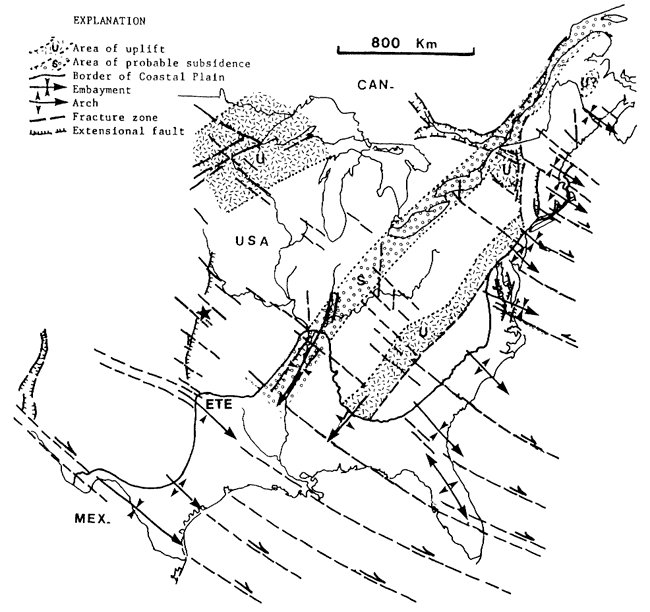
Folding and thrust faulting required a change from regional crustal tension to regional compression. This may have taken place in late Cretaceous time, when the Larimide Orogeny began in the Rocky Mountain region to the west. The mid-plate crustal block is still subject to east-northeast regional compression today (Johnson and Nava 1990). Thus, the folding and thrusting of surficial bedrock in Butler County may have occurred during the late Cretaceous or Cenozoic.
DRAINAGE DEVELOPMENT
Upland chert gravels:
Chert gravel deposits are common on high terraces and hill tops in southern Butler and northernmost Cowley Counties (Fig. 11). The distribution of these gravels is indicated by the Olpe-Norge soil, as shown on the Soil survey of Butler County, Kansas (Penner et al. 1975). Upland gravel deposits (map unit 13) were mapped wherever greater than 3 feet in thickness; maximum thickness is on the order of 8-10 feet.
Figure 11. Map of Butler County (except T. 23 S.) and northern Cowley County showing upland chert gravel deposits, sinkhole zones, and principal streams. High-terrace gravels are < 50 feet and hill-top gravels are > 50 feet above modern valley flood plains. See table 5 for locations of numbered sinkhole zones.
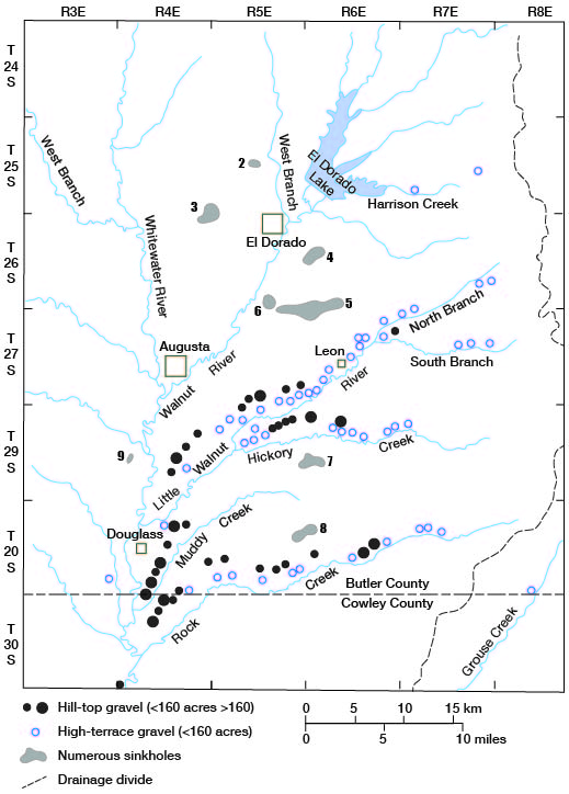
Well-developed paleosols with strong oxidation are often preserved below a cap of thin loess (not mapped) in which the modern soil is developed. Residual (non-transported) chert from the Wreford or Florence Limestones was not included in unit 13 and has not been mapped separately from the bedrock formations.
The old alluvial deposits are associated with the Little Walnut River, Hickory Creek, and Rock Creek (Fig. 11). These streams have entrenched their headwater valleys into or below the Florence Limestone, which is the primary source of chert. Streams in northern Butler County either have not yet entrenched below the Ft. Riley Limestone or are just beginning to erode into the Florence Limestone. This explains the general lack of older chert alluvium in the upper Walnut drainage basin.
These alluvial deposits of chert gravel were described by Sleezer (1990). Because of their widespread distribution and significance in the local landscape, I propose to give these deposits formation status and designate them as the "Leon Gravel" after the city of Leon. The name Leon is not listed as a stratigraphic term employed in Kansas (Sorensen et al. 1989). As used here, the Leon Gravel is equivalent to the Olpe-Norge soil map unit of Penner et al. (1975).
The Leon Gravel can be locally separated into upper and lower members on the basis of topographic position in relation to adjacent modern valleys (Fig. 12):
1. Lower member: high-terrace positions, roughly 20 to 40 feet above modern flood plains. Olpe soil B horizon color is typically moderate brown (5 YR 4/4).
2. Upper member: hill-top or drainage-divide positions, around 70 to 90 feet above modern flood plains. Olpe soil B horizon color is typically moderate to dark reddish brown (10 R 4/6 to 3/4).
Figure 12. Portion of Leon topographic quadrangle showing distribution of Leon Gravel (map unit 13). Gravels north of Little Walnut Valley were deposited by ancestral Little Walnut River; gravels to south are related to Hickory Creek located south of map. Map slightly reduced from original 1:24,000 scale.
The Leon Gravel is thought to be more-or-less equivalent to Neogene chert gravels that are common in the Neosho and Marais des Cygnes basins east of the Flint Hills (Aber 1985, 1988). However, the true age of the Leon Gravel is uncertain. Erratic pebbles of quartz and quartzite are present, but extremely rare, in both high-terrace and hill-top gravels associated with tributary streams east of the Walnut River. These quartzite erratics were presumably reworked from Ogallala-type gravel of High Plains provenance.
Leon Gravel in hill-top positions beside the Walnut River valley south of Douglass is noticeably different from upstream gravel deposits. Gravel south of Douglass is thick (10 feet), has a high content of coarse quartz sand, and has a high content of milky quartz pebbles derived from the Nolands Limestone. Erratic quartzite pebbles are relatively abundant in this vicinity. All these features indicate a major influx of sediment coming into the ancestral Walnut basin from the west.
It is likely that the Arkansas River once flowed eastward from the Wichita vicinity into southern Butler County; it may have flowed across the Flint Hills escarpment into southeastern Kansas. This would explain the presence of quartzite erratics in Leon Gravel throughout southern Butler County. Drainage in eastern Butler County was reversed when the Arkansas River was diverted southward along the path of the Walnut River. Another later diversion rerouted the Arkansas River southward in its modern location and left the Walnut River in its present drainage basin. The timing of these drainage shifts is unknown.
Leon Gravel is preferentially preserved to the north of modern valleys. Rivers have migrated southward as they entrenched bedrock valleys. I have interpreted this pattern as a result of crustal tilting down to the south throughout eastern Kansas (Aber 1990). This may reflect long-term regional downwarping in the midcontinent toward the East Texas Embayment (Fig. 10). Work is continuing to establish some quantitative estimates of the rates of southward river shifting, valley downcutting, and the degree of crustal tilting. However, this effort is hampered by a lack of age control for the Leon Gravel.
Structural control of drainage:
It is clear that structural features have exerted a strong influence on stream erosion patterns in Butler County. Streams follow the troughs of synclines in several places; the most noteable examples are West Branch Walnut River and Grouse Creek (Fig. 8). Joint sets have likewise influenced drainage development. Most eastern tributaries of the Walnut River flow downdip, parallel to joint set 1 (50-65°); examples include the Little Walnut River and its North Branch and portions of Rock Creek (Fig. 11). Hickory Creek and parts of Rock Creek valleys are parallel to joint set 5 (70-80°).
The western tributaries of Walnut River follow valleys that are mostly parallel to joint set 2 (310-335°), including the West Branch Whitewater River. Joint set 3 (15-35°) relates to the main stem of the Walnut River northeast of Augusta, including the west arm of El Dorado Lake. These two trends correspond to major lineaments found throughout eastern Kansas (Burchett et al. 1983).
Lack of structural influence on drainage is also evident in some cases. The main N-S drainage trend of the Whitewater River and the Walnut River south of Augusta does not correspond to observed joints or folds. The near E-W trends of several smaller stream segments are likewise not clearly related to joints in eastern Butler County.
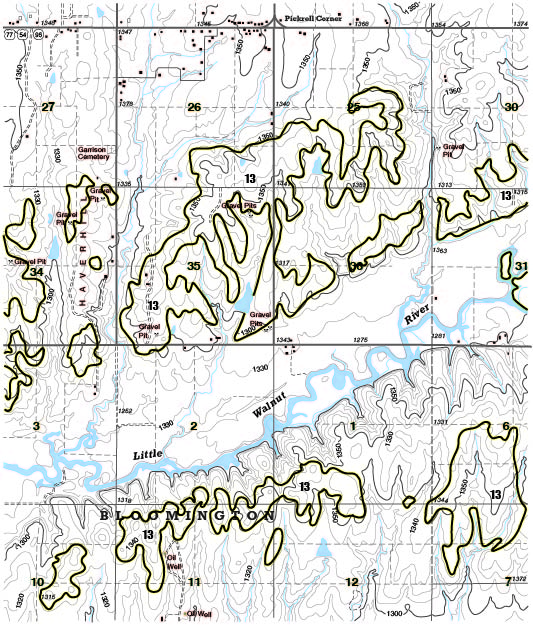
Sinkholes:
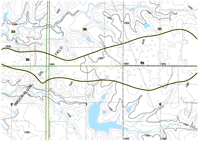
Sinkholes are common in the Ft. Riley Limestone in several parts of Butler County (Fig. 11). Where present, sinkholes are quite numerous and conspicuous; a density of 10 or more sinkholes per quarter section is typical (Fig 13). Elsewhere sinkholes are generally lacking in the Ft. Riley outcrop region. A total of 9 zones of sinkhole development were identified (map unit 9s) in Butler County (Table 5).
Table 5. Locations of sinkhole zones in the Ft. Riley Limestone of Butler County (see Fig. 11).
| Quadrangle | Location | Oil Field |
|---|---|---|
| 1. Matfield Green | NW sec. 25 T. 23 S., R. 7 E. | none |
| 2. El Dorado SW | S2 sec. 16, T. 25 S., R. 5 E. | El Dorado |
| 3. El Dorado SW | E2 sec. 36, T. 25 S., R. 4 E.; W2 sec. 31, T. 25 S., R. 5 E.; NE sec. 1, T. 26 S., R. 4 E.; NW sec. 6, T. 26 S., R. 5 E. |
El Dorado |
| 4. El Dorado | SE sec. 13, T. 26 S., R. 5 E.; sec. 18, T. 26 S., R. 6 E.; NW sec. 17, T. 26 S., R. 6 E. |
Smock Sluss |
| 5. Leon | S2 sec. 31, S2 sec. 32, W2 sec. 33, T. 26 S., R. 6 E.; N2 sec. 6, T. 27 S., R. 6 E.; S2 sec. 35, S2 sec. 36, T. 26 S., R. 5 E.; N2 sec. 1, NE sec. 2, T. 27 S., R. 5 E. |
Smock Sluss |
| 6. Leon | sec. 34, T. 26 S., R. 5 E. | Smock Sluss |
| 7. Augusta SE | SW sec. 24, T. 28 S., R. 5 E.; sec. 19, SW sec. 20, T. 28 S., R. 6 E. |
Fox-Bush (north) |
| 8. Augusta SE | NW sec. 13, T. 29 S., R. 5 E.; S2 sec. 7, T. 29 S., R. 6 E. |
Fox-Bush (south) |
| 9. Douglass | NE sec. 19, NW sec. 20, T. 28 S., R. 4 E. | Augusta (south) |
Figure 13. Portion of Leon topographic quadrangle showing region mapped as unit 9s: numerous sinkholes developed in Ft. Riley Limestone. Map slightly reduced from original 1:24,000 scale.
Zones of dense sinkhole development are associated with several structural and topographic conditions:
- structural crests of anticlines.
- portions of active oil fields.
- upland drainage divides.
- nearly level to gently sloping land surface.
- entrenched river valleys nearby.
- lack of thick surficial cover (chert gravel or loess).
These factors in combination are thought to enhance the possibility for vertical drainage of water into highly fractured, soluble bedrock with resulting sinkhole solution. Many springs and caves are also known in the vicinity of sinkhole zones, especially in the region between El Dorado and Leon. All sinkhole zones, except number 1, meet all these conditions. Zone 1 is the smallest in area and is not associated with an oil field, a known structural dome, or an entrenched stream valley.
Valley alluvium:
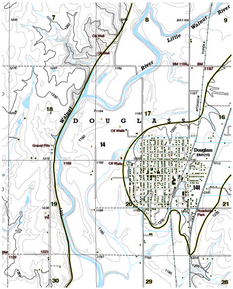
The alluvial fill of valleys is mostly present beneath low-lying valley bottoms that are subject to periodic flooding. This alluvium (map unit 14) consists mainly of silt, clay and fine sand, in which poorly developed paleosols are present a few feet below the modern surface. In a few areas, however, alluvium forms low terraces, with surfaces 10 to 20 feet above the adjacent flood plain. These low terraces (map unit 141) are particularly conspicuous in the Whitewater and lower Walnut valleys. The city of Douglass is situated on such a terrace, and so this terrace is here referred to as the "Douglass terrace" (Fig. 14).
Figure 14. Portion of Douglass topographic quadrangle showing low terrace (unit 14t), on which city of Douglass is located, and alluvium (unit 14) in Walnut River valley.
A good exposure of alluvium underlying a low terrace is located along Four Mile Creek in SE sec. 32, T. 27 S., R. 3 E. (Fig. 15). The low terrace at this site is mapped as Norge soil (Penner et al. 1975); its characteristics are given in Table 6.
Table 6. Vertical section and description of alluvium below the low terrace on Four Mile Creek (see Fig. 15).
| Feet | Description |
|---|---|
| 0 | surface of low terrace, elevation = 1275 feet. |
| 0-1 | loess soil, 10 YR 2/2. |
| 1-6 | silty clay and clayey silt, 5 YR 4/4. |
| 6-10 | silty clay and clayey silt, 5 YR 6/4. |
| 10-17.5 | clayey silt with numerous, irregular carbonate concretions, 5 YR 6/4. |
| 17.5-19 | carbonate-cemented conglomerate consisting of cross-bedded pebbles and coarse sand. Limestone and shale are predominant with some milky quartz and rare quartzite pebbles. Small snail shells are also present. |
| 19-24 | unconsolidated limestone gravel with silty, sandy, clay matrix. |
| 24 | Four Mile Creek. |
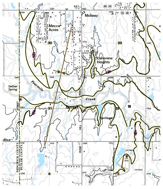
The conglomerate layer was likely cemented by mineralized ground water that emerges from a series of springs a short distance upstream along Four Mile Creek (Fig. 15). These springs, including the well-known Seltzer Spring, are located in the trough of a subtle syncline (Seltzer Syncline), and their positions correspond to outcrops of the Hollenberg Limestone Member (map unit 12h) of the Wellington Formation. A similar, travertine-cemented conglomerate is located on the south side of Four Mile Creek valley at the Butler/Sedgwick County line.
Figure 15. Portions of Santa Fe Lake and Andover topographic quadrangles showing locations of travertine-cemented conglomerate (asterisks) beneath low-terrace alluvium of Four Mile Creek valley. Note association of springs with Hollenberg Limestone (unit 12h) within syncline.
Comparison of Butler County Mapping with Other Maps
The Butler County map has been compared along the northern and southern boundaries with county maps for Chase and Cowley Counties. The Chase County map (Moore et al. 1951) generally agrees well. Minor discrepancy is visible in the southwest corner of Chase County, on the north flank of Burns Dome. Bedrock dips northward here, in places as steeply as 80 feet per mile. The Cowley County map (Bayne 1962) utilizes some different stratigraphic boundaries and units; nonetheless, reasonable agreement is evident along much of the Butler County border.
Major differences exist between this map of Butler County and what appears on the state geologic map (Jewett 1964). The Ft. Riley Limestone is much more extensive than is indicated on the state map: in the Cassoday vicinity, southward to near Rosalia, and westward to El Dorado. The state map shows several sizable areas of Wellington Shale on uplands east of the Whitewater River valley. These areas are, in fact, capped with the Nolands Limestone; Wellington Shale of mappable thickness is only present west of the Whitewater River valley.
The state map does not indicate any of the upland chert gravel deposits. The location of loess shown on the state map is not consistent with distribution of the Goessel Soil (Penner et al. 1975). The features shown on the state geologic map have been repeated with few changes on Kellogg's (1978) map of Butler County and on O'Conner et al.'s (1982) map of southwestern Butler County.
References
Aber, J.S. 1985. Quartzite-bearing gravels and drainage development in eastern Kansas: Ter-Qua Symposium Series 1:105-110.
Aber, J.S. 1988. Upland chert gravels of east-central Kansas: Kansas Geol. Survey, Guidebook Series 6:17-19.
Aber, J.S. 1990. Chert gravel, Neogene drainage development, and neotectonism in the Neosho and Walnut drainage basins of eastern Kansas: Geol. Soc. America, Abs. with Prog. 22, no. 7, p. A372-373.
Baars, D.L., and Maples, C.G. 1990. Redefinition of the Upper Pennsylvanian Virgilian Series in Kansas: Geol. Soc. America, Abs. with Prog. 22, no. 7, p. A44.
Barosh, P.J. 1990. Neotectonic movement and earthquake assessment in the eastern United States: Geol. Soc. America, Reviews in Engineering Geology 8:77-109.
Bayne, C.K. 1962. Geology and ground-water resources of Cowley County, Kansas. Kansas Geol. Survey, Bulletin 158, 219 p. [available online]
Bickford, M.E., Harrower, K.L., Nusbaum, R.L., Thomas, J.J., and Nelson, G.E. 1979. Preliminary geologic map of the Precambrian basement rocks of Kansas: Kansas Geol. Survey, Map M-9, 1:500,000. [available online]
Burchett, R.R., Luza, K.V., Van Eck, O.J., and Wilson, F. 1983. Seismicity and tectonic relationships of the Nemaha Uplift and midcontinent geophysical anomaly: U.S. Nuclear Regulatory Commission, NUREG/CR-3117.
Fath, A.E. 1921. Geology of the El Dorado Oil and Gas Field, Butler County, Kansas: Kansas Geol. Survey, Bulletin 7, 187 p. [available online]
Imbrie, J., Laporte, L.F., and Merriam, D.F. 1964. Beattie Limestone facies (Lower Permian) of the northern Midcontinent: Kansas Geol. Survey, Bulletin 169, vol. 1, p. 219-238. [available online]
Jewett, J.M. 1964. Geologic map of Kansas: Kansas Geol. Survey, Map M-1, 1:500,000.
Johnson, A.C., and Nava, S.J. 1990. Seismic-hazard assessment in the central United States: Geol. Soc. America, Reviews in Engineering Geology 8:47-58.
Kellogg, D. 1978. Areal geology of Butler County, Kansas: Unpub. Master's thesis, Wichita State Univ., 151 p.
Klein, G.deV., and Willard, D.A. 1989. Origin of Pennsylvanian coal-bearing cyclothems of North America: Geology 17:152-155.
Lutz-Garihan, A.B., and Cuffey, R.J. 1979. Stratigraphy of the Lower Permian Wreford megacyclothem in southernmost Kansas and northern Oklahoma: Kansas Geol. Survey, Bulletin 216, 19 p. [available online]
McCrone, A.W. 1964. Water depth and midcontinent cyclothems: Kansas Geol. Survey, Bulletin 169, vol. 1, p. 275-281. [available online]
Moore, R.C. 1964. Paleoecological aspects of Kansas Pennsylvanian and Permian cyclothems: Kansas Geol. Survey, Bulletin 169, vol. 1, p. 287-380. [available online]
Moore, R.C., Jewett, J.M., and O'Conner, H.G. 1951. Areal geology of Chase County, Kansas: Kansas Geol. Survey, Volume 11, plate 1. [available online]
O'Conner, H.G., Chaffee, P., and Link, M. 1982. Geohydrology of southwestern Butler County, Kansas: A preliminary report: Kansas Geol. Survey, Open File Report 82-2.
Penner, H.L., Ekart, S.C., Ewing, D.A., Schmidt, G., and Smith, J. 1975. Soil survey of Butler County, Kansas: U.S. Department Agriculture, Soil Conservation Service.
Sleezer, R.O. 1990. Drainage development and chert gravel deposits in Butler County, Kansas: Unpub. Master's thesis, Emporia State University, 37 p.
Sorensen, J.H., Johnsgard, S.J., and Wozencraft, C. 1989. Bibliography of Kansas geology, 1823-1984: Kansas Geol. Survey, Bu1letin 221, 444 p.
Ward, J.R. 1968. A study of the joint patterns in gently dipping sedimentary rocks of south-central Kansas: Kansas Geol. Survey, Bulletin 191, part 2, 23 p. [available online]
White, D.C. 1990. Lineament study of stream patterns in a portion of east-central Kansas: Unpub. Master's thesis, Emporia State University, 57 p.
Zeller, D.E. (editor) 1968. The stratigraphic succession in Kansas: Kansas Geol. Survey, Bulletin 189, 81 p. [available online]