Kansas Geological Survey, Bulletin 216, originally published in 1979
Originally published in 1979 as Kansas Geological Survey Bulletin 216. This is, in general, the original text as published. The information has not been updated.
Previous studies of the Nebraska and Kansas portions of the Wreford Megacyclothem have yielded extensive knowledge of the lithology, stratigraphic relationships, paleogeography, and paleoenvironmental implications of these rocks. However, comparably detailed understanding of the Oklahoma Wreford has not been achieved until now, as presented in this paper. This thorough knowledge of Wreford stratigraphy will provide background for making detailed studies of the various well-preserved Wreford fossil groups. An improved understanding of the environment at the time of deposition of the Wreford will result.
Field tracing of the stratigraphic units of the Wreford Megacyclothem into northern Oklahoma reveals that major facies changes take place within a short distance south of the Kansas-Oklahoma border; there, all of the typically marine Wreford horizons of Kansas grade laterally into interbedded red shales and red sandstones. Several units (the entire Speiser, middle and upper Havensville, upper Schroyer, and the Wymore) become red beds only a few miles south of the border. The remaining horizons comprise two marine tongues extending farther south and thus indicate shoreline fluctuations of the Wreford sea. The upper tongue, newly discovered and poorly exposed, includes algal-molluscan limestone (lower Schroyer) overlain by grayish-yellow mudstone (middle Schroyer), and extends to about 40 miles (64 km) south of the state line. The lower tongue consists of two algal-molluscan limestones (lower Threemile and lower Havensville equivalent) bracketing a thin brachiopod-molluscan limestone (middle and upper Threemile), and extends to about 50 miles (80 km) south of the border. Both tongues pass through tan quartzose sandstone or red clayey molluscan limestone as they grade southward into red shale and red sandstone.
The Wreford in Oklahoma is dominated by fewer rock types than in Kansas. Red shales interbedded with red sandstones comprise the greatest volume of any rock type. Also important are pelecypod-burrowed algal-molluscan limestones. These rocks show southward increases in molluscs, algally ("Osagia") or inorganically coated grains, and fine quartz sand content, along with a simultaneous decrease in brachiopods and bryozoans. These limestones may represent calcarenite shoals as well as shallow, level bottoms in the Wreford sea, immediately offshore from the coastal plain to the south. Other distinctive Oklahoma Wreford rock types include tan quartzose sandstone and red clayey molluscan limestone.
The stratigraphy and environments of deposition of the Lower Permian Wreford Megacyclothem in Kansas were studied intensively by Hattin (1957). Thus, it became possible to accomplish detailed investigations of the various fossil groups present in the Wreford Megacyclothem against the stratigraphic, lithologic, paleoecologic, and geographic background provided by Hattin's Kansas study.
Such detailed paleontologic investigations began with study (Cuffey, 1967) of the bryozoan Tabulipora carbonaria. Treatments of the Wreford rhomboporoids (Newton, 1971) and fistuliporoids (Warner and Cuffey, 1973) soon followed. Currently, in addition to several other bryozoan groups, the various brachiopod groups present in the Wreford Megacyclothem are being studied; investigation of the Wreford population of the brachiopod Composita has been completed (Garihan, 1973; Lutz-Garihan, 1976).
Because Hattin (1957) had worked out the detailed stratigraphy of the Wreford only within the boundaries of Kansas, comparably extensive interpretation of the southernmost portions of the megacyclothem did not exist until now. Therefore, in order to provide comprehensive knowledge of the Oklahoma Wreford and to complete the detailed background for bryozoan and brachiopod investigations in progress, measured stratigraphic sections (Appendix) of the Wreford Megacyclothem in Oklahoma were studied in detail. Results of this study are reported in this paper; the information concerning the detailed stratigraphy of the Oklahoma Wreford is presented so that it can be meshed with knowledge of the Kansas Wreford. Therefore, for the first time a comprehensive view of the entire Wreford throughout its geographic extent can be obtained.
As the basis for the present study, stratigraphic sections were examined and measured, and rock samples (as well as brachiopods) were collected from Wreford outcrops in southernmost Kansas and northern Oklahoma. These measured sections are described in the Appendix.
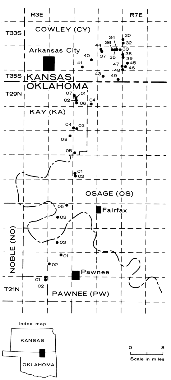
Localities upon which the extension of Wreford stratigraphy into Oklahoma is based are briefly listed (Table 1) and mapped (Figure 1). More detailed descriptions of each may be found in previous papers (Cuffey, 1967; Newton, 1971; Lutz-Garihan, 1976). The numbering system for those works is continued here in order to facilitate integrated use of all these contributions.
Table 1--Wreford localities in southernmost Kansas and northern Oklahoma.
| Number | Type | Location |
|---|---|---|
| Cowley Co., Kansas | ||
| CY30 | road cut | NW sec. 30, T. 33 S., R. 7 E. |
| CY32 | road cut | SW sec. 31, T. 33 S., R. 7 E. |
| CY33 | road cut | NE sec. 12, T. 34 S., R. 6 E. |
| CY34 | road cut | NW sec. 11, T. 34 S., R. 6 E. |
| CY35 | road cut | NW sec. 11, T. 34 S., R. 6 E. |
| CY36 | road cut | NE sec. 10, T. 34 S., R. 6 E. |
| CY37 | spillway | SW sec. 8, T. 34 S., R. 6 E. |
| CY38 | road cut | SW sec. 18, T. 34 S., R. 7 E. |
| CY39 | road cut | SW sec. 18, T. 34 S., R. 7 E. |
| CY40 | road cut | center sec. 23, T. 34 S., R. 5 E. |
| CY41 | stream bed | NW sec. 33, T. 34 S., R. 5 E. |
| CY43 | stream cut | SE sec. 8, T. 35 S., R. 6 E. |
| CY44 | gully | SE sec. 7, T. 34 S., R. 6 E. |
| CY45 | gully | NW sec. 29, T. 34 S., R. 7 E. |
| CY46 | road cut | SE sec. 30, T. 34 S., R. 7 E. |
| CY47 | road cut | NW sec. 31, T. 34 S., R. 7 E. |
| CY48 | road ditch | SW sec. 31, T. 34 S., R. 7 E. |
| CY49 | stream cut | NW sec. 13, T. 35 S., R. 6 E. |
| Kay Co., Oklahoma | ||
| KAOI | road ditch | NE sec. 30, T. 29 N., R. 5 E. |
| KA02 | road cut | NE sec. 30, T. 29 N., R. 5 E. |
| KA03 | gully | SW sec. 31, T. 28 N., R. 5 E. |
| KA04 | road cut | SW sec. 31, T. 28 N., R. 5 E. |
| KA05 | butte top | SW sec. 31, T. 27 N., R. 5 E. |
| KA06 | road cut | SW sec. 29, T. 29 N., R. 5 E. |
| KA07 | stream cut | NW sec. 19, T. 29 N., R. 5 E. |
| KAOS | hillside | NW sec. 12, T. 27 N., R. 4 E. |
| Osage Co., Oklahoma | ||
| OS01 | road cut | SE sec. 30, T. 26 N., R. 5 E. |
| OS02 | gully | NE sec. 31, T. 26 N., R. 5 E. |
| OS03 | butte top | NW sec. 21, T. 24 N., R. 4 E. |
| OS04 | road cut | SW sec. 35, T. 29 N., R. 5 E. |
| OS05 | road ditch | NE sec. 2, T. 24 N., R. 4 E. |
| Pawnee Co., Oklahoma | ||
| PW0I | road cut | SW sec. 3, T. 22 N., R. E. |
| PW02 | road cut | SW sec. 18, T. 22 N., R. E. |
| PW03 | road cut | SW sec. 21, T. 23 N., R. 4 E. |
| Noble Co., Oklahoma | ||
| NO0I | road ditch | NE sec. 1, T. 21 N., R. 3 E. |
| NO02 | road ditch | NE sec. 1, T. 21 N., R. 3 E. |
Figure 1--Wreford localities in southernmost Kansas and northern Oklahoma (separately numbered in each county).
Rock samples included bulk samples of shales for laboratory kerosining, chips of indurated rocks (mostly limestones and sandstones) for oriented thin-sections, and chunks of limestones, sandstones, and shales for insoluble residue studies. Thin-sections of key beds were examined to determine both rock type and fossil content.
Insoluble residues, determined as weight percentages of constituents for key beds, also provided information relevant to the present stratigraphic study. These percentages are indicated in the Appendix. The rock samples were crushed and weighed and then dissolved in acetic acid for two to four days; the resulting residue was dried and weighed. The residue was next washed through a 100 mesh screen (to remove the clays), dried again, and finally observed with a binocular dissecting microscope.
Historical summaries elsewhere (Hattin, 1957, p. 7-9; Cuffey, 1967, p. 8) adequately review the discovery and naming of the rock units contained in the Wreford Megacyclothem in Kansas, and thus will not be repeated here.
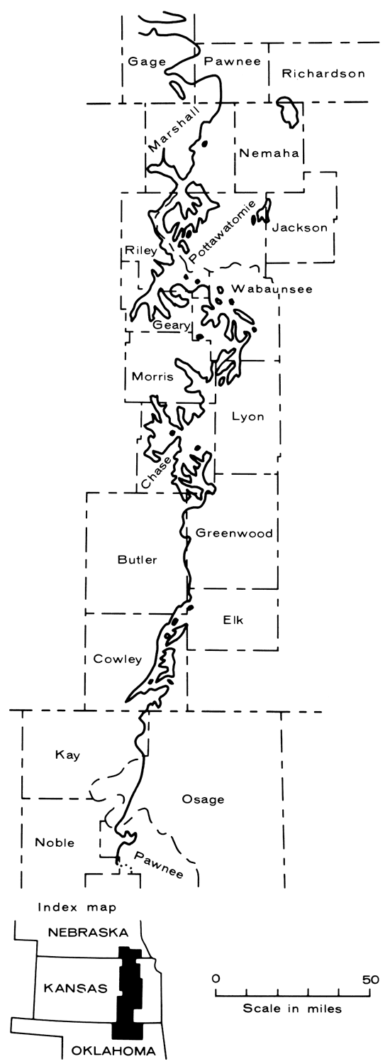
The location of the Wreford outcrop belt in Nebraska, Kansas, and Oklahoma is shown in Figure 2. In Nebraska, the Wreford is largely obscured by glacial deposits; moreover, only about 30 miles (48 km) north of the Nebraska-Kansas border, it disappears beneath Cretaceous rocks (Newton, 1971, p. 13). In Kansas, the Wreford rocks are widely exposed, yield abundant fossils, and display their cyclic character extremely well. However, once into Oklahoma, these rocks exhibit drastic changes. The entire Wreford section becomes a series of interbedded red shales and red sandstones, making the megacyclothem unrecognizable beyond a point about 50 miles (80 km) south of the Kansas-Oklahoma border (Garihan, 1973; Garihan and Cuffey, 1973). Newton (1971, p. 13-14) briefly reported results of a reconnaissance survey of these changes; the present paper contains results from a detailed investigation of Oklahoma Wreford stratigraphy. It modifies some and confirms other of his conclusions.
Figure 2--Outcrop of Wreford Limestone in Nebraska, Kansas, and Oklahoma (adapted from Geologic Bedrock Map of South-eastern Nebraska, 1966; Geologic Map of Kansas, 1964; and Geologic Map of Oklahoma, 1954).
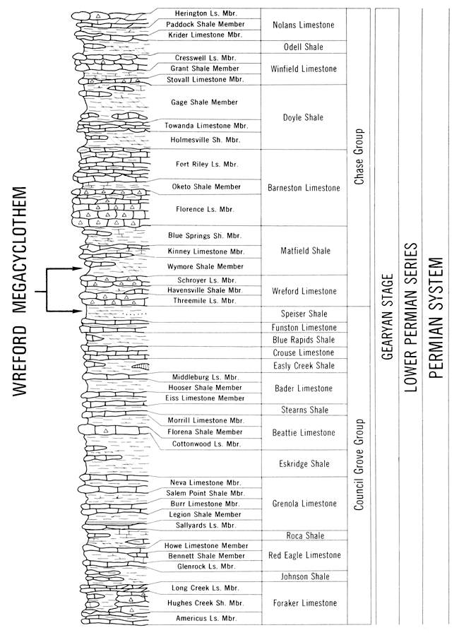
The rock units that contain the Wreford Megacyclothem are of Early Permian age, and belong to the top of the Council Grove Group and the basal Chase Group (Figure 3; Zeller, 1968, p. 43-48). The two cyclothems included in the Wreford (and indicated on Plate 1) are the Threemile cyclothem below and the Schroyer cyclothem above.
Figure 3-Stratigraphic column of part of the Kansas Lower Permian, including units contained in the Wreford Megacyclothem (adapted from Zeller, 1968).
The detailed stratigraphy of the Wreford Megacyclothem throughout its region of outcrop can be summarized succinctly by the large cross-section (Plate 1). This cross-section represents updating of preliminary versions (Cuffey, 1967, p. 14-15; Newton, 1971, p. 8-9) along with new information generated by the present stratigraphic investigation and by companion Wreford brachiopod (Lutz-Garihan, in preparation) and bryozoan (Cuffey, in preparation) studies.
The many thin strata included within the Wreford Megacyclothem represent comparatively few rock types which recur in a cyclic pattern. The characteristics and paleoenvironmental interpretations of these rock types in Kansas have been treated in detail by Hattin (1957, p. 51-104), Cuffey (1967, p. 10-13), and Newton (1971, p. 7-10). This information is briefly summarized here (Tables 2 and 3; see also Garihan, 1973, p. 191-198) to provide necessary background for the present stratigraphic study. In addition, a few papers which shed light on other aspects of Wreford rock types have appeared since these detailed descriptions.
Table 2--Abbreviations for Wreford rock types, used in Table 3 and Figure 4 to summarize aspects of Wreford stratigraphy.
| Abbreviation | Rock Type |
|---|---|
| alg ls | algal limestone |
| alg-moll ls | algal-molluscan limestone |
| argill ls | argillaceous limestone |
| black sh | black shale |
| brach-moll ls | brachiopod-molluscan limestone |
| calc sh | calcareous shale |
| chlky ls | chalky limestone |
| chnl cgl | channel conglomerate |
| chty ls | cherty limestone |
| coal | coal |
| grn sh | green shale |
| gr-yl mud | gray-yellow mudstone |
| int brecc | intraformational breccia |
| moll ls | molluscan limestone |
| red sh | red shale |
| red ss | red channel sandstone |
| resid cl | red residual clay |
| tan ss | tan quartzose sandstone |
Table 3--Paleoenvironmental interpretations of Wreford rock types, considered in approximate cyclic order (compiled from Hattin, 1957; Cuffey, 1967; and Newton, 1971).
| Rock Type | Water Depth | Distance from Shore | Salinity | Water Movement | Substrate | Physiography |
|---|---|---|---|---|---|---|
| tan ss | very shallow | near | brackish | moderate | terrigenous sand | level sea bottom or intertidal flat |
| alg-moll ls | very shallow to 10'(?) to 60'(?) | near | brackish | moderate | carbonate mud or sand | level sea bottom or intertidal flat |
| alg ls | very shallow to 10'(?) to 60'(?) | near | brackish? (possibly hypersaline?) | sometimes moderate | carbonate sand or mud | level sea bottom or calcarenite shoal |
| chlky ls | very shallow to 10'(?) to 60'(?) | near to far | normal marine | weak? | carbonate mud | carbonate mud banks |
| chty ls | 10' to 60' | near to far | normal marine | none | carbonate mud | level sea bottom |
| calc sh | 10' to 30' (possibly to 60') | near to far | normal marine | none | mixed terrigenous and carbonate mud | level sea bottom |
| brach-moll ls | 10' to 60' | near to far | normal marine or brackish | none to weak | carbonate mud | level sea bottom |
| moll ls | 10' to 60' | near to far | normal marine or brackish | weak | carbonate mud | level sea bottom |
| int brecc | very ~h-allow | near to far | normal marine or brackish | strong | mixed mud | level sea bottom |
| gry-yl mud | very shallow | near | brackish | weak? | terrigenous mud | level sea bottom |
| coal; black sh | very shallow | near | brackish | none? | plant debris | depressions in sea bottom |
| grn sh | very shallow or low intertidal | very near or onshore | brackish | weak? | terrigenous mud | intertidal flat or level sea bottom |
| red sh | very shallow or high intertidal | very near or onshore | fresh or brackish | weak? | terrigenous mud | flood plain or intertidal flat |
| red ss | very shallow | very near or onshore | fresh or brackish | strong | terrigenous sand | stream channel |
| chnl cgl | very shallow | very near or onshore | fresh or brackish | strong | terrigenous gravel | stream channel |
Rasmussen and others (1971) report that a vertebrate assemblage from an intraformational conglomerate of Late Pennsylvanian age in Kansas includes sharks, fishes, reptiles, and amphibians. Thus, both fresh-water and marine vertebrates contributed to the debris found in these channel conglomerates.
Lee (1972) found little change vertically in clay mineralogy of the Havensville Shale Member, but significant variation laterally between near-shore and offshore marine shales. Kaolinite is found only in near-shore facies in southern Kansas. Montmorillonite decreases northward as illite increases, although some illite was probably derived diagenetically from the montmorillonite. Mixed-layer chlorite exists at all the localities studied but decreases in abundance northward. He concluded that both detrital and diagenetic effects are evident in this Havensville clay-mineral assemblage.
Isotopic data were also considered for the clay minerals of the Havensville Shale (Chaudhuri and Lee, 1972). These data imply that the clay minerals (especially illite) had inherited radiogenic strontium at the time of deposition, that the illites are detrital, and that the clays from northern versus southern Kansas were derived from different sources.
Chaudhuri and Methot (1972) discussed reasons for high Sr87/Sr 86 values in Permian limestones in general, because a high value may imply that this ratio was also high for the isotopic composition of the environment of deposition. They conclude merely that the strontium-isotopic composition of limestones might help in reconstructing the environment in which these rocks were formed.
Turning attention again to more general matters, the distribution of the various rock types throughout the formally recognized rock-stratigraphic units containing the Wreford Megacyclothem also has been considered extensively by previous writers (Hattin, 1957, p. 24-50; Cuffey, 1967, p. 13-14). Again, this information is presented succinctly by the detailed cross-section (Plate 1), and is also summarized by Garihan (1973, p. 199-202).
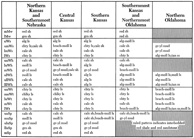
Inspection of the Wreford cross-section (Plate 1) indicates that many strata can be traced laterally for considerable distances. Further study has permitted the subdivision of the Wreford strata into 22 successive stratigraphic horizons (Cuffey, 1967, p. 71-72), each dominated by one or only a few rock types as it is traced laterally throughout the Wreford outcrop belt. Because these horizons have proven so useful in previous studies (as, for example, Cuffey, 1967, p. 73-78), they have been tabulated here (Table 4). The dominant rock types at each horizon in each geographic region are also briefly indicated (Figure 4), although this information could also have been presented in more detail in the form of 22 lithofacies maps, one for each of the 22 horizons.
Table 4--Abbreviations for stratigraphic horizons recognized within the Megacyclothem and utilized in clarifying Wreford stratigraphy in southernmost Kansas and Oklahoma.
Figure 4--Dominant rock types at each Wreford stratigraphic horizon in different geographic areas; rock type abbreviations from Table 2, stratigraphic horizon abbreviations from Table 4.
Each of the 22 Wreford horizons mapped is a rock unit, rather than a time unit. There is no firm evidence for precisely locating time lines within the sections; for example, there are no marker beds such as bentonite layers that could indicate a time plane over the whole region. Consequently, the exact time significance of the 22 horizons is uncertain. Within Kansas, most workers have assumed that a cyclothemic bed of a particular lithology is essentially time-parallel, and this has seemed a reasonable presumption in view of the remarkably widespread geographic extent and lithologic and thickness similarities of the rock units. McCrone (1963, p. 50) believed that a knife-sharp contact between a limestone and a black shale in the Red Eagle Cyclothem reflected a sudden widespread change in conditions of deposition and thus could be considered a time line. He then assumed that the rest of the rock units in the Red Eagle Cyclothem were also contemporaneous.
When the Wreford is traced into Oklahoma, where most of the beds thin drastically and change lithology, the 22 stratigraphic horizons recognized in the Kansas Wreford can still be followed. Thus, although precise time relationships southward into Oklahoma are not certain, it still would seem reasonable to regard these horizons as essentially synchronous planes there, in the absence of evidence to the contrary.
The rock units cropping out in east-central Oklahoma, a series of interbedded red sandstones and red shales, presented several problems to stratigraphers in the late 1800s. These problems included the geographic distribution of their red color, their geologic age, and their relationships to rocks in the adjoining states of Kansas and Texas (Beede, 1907).
In Texas, the red beds were initially assigned ages ranging from Permian to Tertiary, but only on the basis of lithostratigraphic evidence. Paleontologic dating was first employed when Cope (1878) recognized the red beds as Permian, based on their contained vertebrate fossils. White (1889) described the first invertebrate fossils from the same units and concurred that the rocks were Permian. In 1901, Cummins divided the Texas Permian into three divisions, and for the first time indicated upper and lower boundaries for the Permian of this region. Cummins (1897) also noted that by walking north along an outcrop belt in Texas, the gradual lithologic change of a particular unit from fossiliferous limestone to unfossiliferous calcareous sandy clay could be observed.
In Kansas, many rock units are light-colored marine limestones with abundant invertebrate fossils which allowed early determination of their Permian age by various workers. Expanding upon this evidence, Cragin (1897) assigned a Permian age to the red beds in Kansas.
In Oklahoma, early workers had assumed that the so-called "color line," the northeastern boundary of the geographic area underlain by red beds, paralleled the strike of the late Paleozoic rocks. However, Adams (1898, 1901) traced two Carboniferous limestones along strike from Kansas, where both were gray limestones, into Oklahoma, where both changed to red beds. By noting the localities where these units changed from gray to red in color, Adams mapped a "line of color change," which surprisingly was "diagonal to the strike of the Carboniferous and Permian formations" (Adams, 1901, p. 386). Moreover, Adams' tracing demonstrated that the Oklahoma red beds were of the same age as the marine beds in Kansas. Although the examples studied were Carboniferous, Adams suggested that the same situation applied to the Permian beds and that therefore the Oklahoma red beds were also partly of Permian age. Gould (1901, 1902) also discussed the tracing of light-colored rocks in Kansas into red beds in Oklahoma; in 1905, he presented a geologic map of Oklahoma, in part based upon this practice.
Knowing that the Permian rocks of Kansas have their equivalents in Oklahoma red beds, the next problem was the correlation of specific units. In particular, Kirk (1905) tried to trace the Wreford Limestone across Oklahoma, and concluded that the Wreford is replaced by two coalescing layers of sandstone, the Payne, which in turn could be traced as far south as Norman, Oklahoma. Beede, in his thorough review of Midcontinent red-bed stratigraphic problems (1907, p. 135), mentioned Kirk's work, and expressed the hope that the Wreford-Payne could be traced on into Texas to provide "an unimpeachable connecting link between the Kansas and Texas Permian."
However, this correlation of the Wreford Limestone is not confirmed by the present detailed stratigraphic investigations. They show that the red sandstones in the Oklahoma Wreford are lenticular and do not extend laterally for more than short distances. Moreover, these sandstones are identical to those in southernmost Kansas, which can be interpreted paleoenvironmentally as stream-channel deposits on a wide alluvial coastal plain. Therefore, it is highly unlikely that any sandstone unit would be extensive enough to trace across much or all of Oklahoma. Moreover, in 1905 Kirk had access to only a few rock exposures, and no detailed studies of the sequence of Wreford rock units had yet been made; both factors would greatly magnify the difficulty of accurately correlating a particular unit. For these reasons, Kirk's correlation of the Wreford Limestone is rejected here, and the improbability of Beede's hopes ever being realized is suggested.
Several papers (Heald, 1916; White and others, 1922; Aurin, Officer, and Gould, 1926; Beckwith, 1928; Patterson, 1933; Grieg, 1959) are concerned with Permian rocks in Oklahoma. Information from their measured sections and regional geologic maps was valuable to the present study by indicating localities where the Wreford Megacyclothem units might be examined in outcrop.
The 22 stratigraphic horizons recognized informally within the five formations or members comprising the Wreford Megacyclothem change lithologically from gray shales and limestones to red beds in Oklahoma a few miles south from Kansas. These changes are summarized in the detailed Wreford cross-section (Plate 1) and the chart of dominant lithofacies at each Wreford horizon (Figure 4). The evidence supporting these conclusions may be examined on the correlation chart of measured sections of the Wreford Megacyclothem in southernmost Kansas and Oklahoma (Plate 2); these measured sections are also described in detail in the Appendix.
The changes that occur in the lithology of the various Wreford horizons can be considered in three groups (Garihan and Cuffey, 1973): 1) units that become interbedded red shales and red sandstones about 10 miles (16 km) south of the state line; 2) a newly discovered but poorly exposed marine tongue that extends to about 40 miles (64 km) south of the state line; and 3) a previously recognized and well-exposed marine tongue extending to about 50 miles (80 km) south of the state line.
Many Wreford horizons become interbedded red shales and red sandstones a few miles south of the Kansas-Oklahoma border. These include the middle and upper parts of the Speiser Shale, the middle and upper parts of the Havensville Shale Member, the upper part of the Schroyer Limestone Member, and the lower and middle parts of the Wymore Shale Member. The middle Speiser red shales grade into interbedded red shale and red sandstone just north of the state line, while the various non-cherty limestones and shales of the upper Speiser become red beds about 10 miles (16 km) south of the state line. This red-bed sequence thickens rapidly to the south. The middle and upper Havensville and the upper Schroyer likewise change from shales and non-cherty limestones to red beds a few miles south of the border. Finally, the lower and middle Wymore, red shale in southernmost Kansas, also grades into a thick sequence of interbedded red sandstones and shales at about the same latitude.
The second group of changes to be considered involves those in a newly discovered but poorly exposed upper marine tongue that extends to about 40 miles (64 km) south of the state line. This marine tongue includes the horizons of the lower and middle parts of the Schroyer Limestone Member. The lower Schroyer is cherty limestone in Kansas, but changes to algal-molluscan limestone approximately at the state line. Farther south, this limestone grades into tan quartzose sandstone, and that in turn into red beds. The middle Schroyer is a thin calcareous shale up to 10 miles (16 km) south of the state boundary, and then passes through grayish-yellow mudstone before being replaced by interbedded red shales and red sandstones.
The third group of changes is found within a lower marine tongue that extends somewhat beyond the upper tongue for a total of 50 miles (80 km) down into Oklahoma. This tongue was recognized previously (Grieg, 1959; Newton, 1971) because it is much better exposed than the one just discussed. This lower tongue includes all of the horizons of the Threemile Limestone Member and of the lower part of the Havensville Shale Member. Through most of the extent of this tongue, the lower Threemile and lower Havensville are represented by algal-molluscan limestones that bracket a thin brachiopod-molluscan limestone equivalent to the middle and upper Threemile farther north. At the northern end of this tongue, approximately at the Kansas-Oklahoma border, the lower Threemile grades from the cherty limestone facies found throughout Kansas into brachiopod-molluscan limestone; a few miles farther south that grades in turn into algal-molluscan limestone. The lower Havensville equivalent has already passed from algal limestone into algal-molluscan limestone a few miles north of the border, where these beds have previously been labeled uppermost Threemile (Hattin, 1957, p. 105; Cuffey, 1967, p. 13-14). At the southern end of this lower tongue, the middle brachiopod-molluscan limestone (the middle and upper Threemile equivalent) changes to red beds about 10 miles (16 km) farther north than the algal-molluscan limestones above and below it. These two algal-molluscan limestones thus become separate subtongues. Each grades into tan quartzose sandstone and then a short distance farther south into red clayey molluscan limestone before finally disappearing into the red beds.
The petrologic features and inferred paleoenvironments of those rock types important in the Oklahoma Wreford are described here. Information concerning their characteristics as developed in southernmost Kansas and Oklahoma is stressed. The Wreford Megacyclothem in Oklahoma is dominated by fewer rock types than in Kansas, where a variety of rock types is abundantly represented (see Plate 1).
Virtually all of the rock types for which insoluble residues were examined contain quartz and either hematite or limonite. In most samples, quartz is the dominant constituent, either as subhedral or rounded grains, or as fine-grained masses. Limonite and hematite are present in lesser quantities as distinct grains and encrusted on other grains. A few samples yield small rhombs, many of which are clear, which might be carbonate rhombs secondarily replaced by silica. Also, many samples contain silicified fragments of organisms that originally secreted calcareous shells.
During Wreford deposition, Kansas was covered by a shallow sea, while much of Oklahoma was low-lying coastal plain. Changes in shoreline position are suggested by observing the northernmost occurrences of red beds (Plate 1). In particular, the shoreline, as inferred from the northern limit of red beds, seems to have been in approximately the same position throughout deposition of the Speiser, middle and upper Havensville, and upper Schroyer and Wymore. This lack of shoreline fluctuation confirms that other factors in addition to changing water depth determined the depositional environments (Cuffey, 1967, p. 10-13, 87; Newton, 1971, p. 14). Twice during Wreford time, the shoreline apparently migrated southward significant distances, resulting in deposition of the two marine tongues discussed above.
Interbedded red sandstones and red shales comprise the greatest volume of rock in the Wreford section in Oklahoma. They tend to be relatively poorly exposed because they commonly form vegetated slopes; only at a few localities do massive sandstones form ledges that crop out. Moreover, the lenticular character and limited lateral extent of the red sandstones is evident as these beds are traced within and between outcrops.
The sandstones are red or reddish purple; they range from shaly-bedded to massive and are fine-grained, quartzose, and friable. The shales are red, moderately calcareous, and lack primary features such as graded beds or ripple marks. Fossils are completely absent.
The sand grains of the red sandstones are mostly quartz and are well sorted and angular, probably due to secondary crystal growth; thus, they can be classified petrographically as orthoquartzites. Thin sections of the red shales show a predominance of quartz sand and silt and the presence of hematite or limonite.
Insoluble residues of the red sandstones and red shales are composed mainly of subhedral pink and clear quartz grains, with a substantial amount of hematite coating the quartz and existing as distinct grains. Mica flakes also occur in many of these samples. Amounts of insoluble residues of these rocks, as indicated in the Appendix, range from 87 to 100 percent.
The environmental interpretation of the red sandstones and red shales has been discussed by Hattin (1957, p. 82-85), Cuffey (1967, p. 11), and Newton (1971, p. 7). The sandstones probably represent stream channel deposits, and it seems likely that the red shales represent subaerial coastal plain deposits.
Algal-molluscan limestones are the most conspicuously and extensively exposed rock type in the Oklahoma Wreford.
In outcrop in southernmost Kansas and northern Oklahoma, these limestones are light gray, light yellowish gray, or grayish brown, and weather medium gray to orangish gray and rounded. They are thin-, medium-, or thick-bedded, hard, burrowed, and contain some rust or dark brown spots about 1 mm in diameter. Many "osagites" (rocks containing abundant algally coated grains) (McCrone, 1963, p. 66-67) are included in this rock type. As in Kansas, typical for algal-molluscan limestones are large burrows (up to 5 cm in diameter), formed by large burrowing clams (Allorisma or Aviculopinna) which are found in place at the bottoms of the burrows at some localities (such as OS02). The algal-molluscan limestones change southward; in that direction they have more coated grains ("Osagia"), more molluscs, and fewer brachiopods and bryozoans (these latter are usually absent from the southernmost exposures of these limestones). Also obvious in hand specimens, and in thin sections and insoluble residues, is the increasing abundance of fine quartz sand to the south.
Algal-molluscan limestones, in thin sections, are sparse to packed biomicrites (using the terminology of Folk, 1959, 1962); where there are many coated grains, they may even be classified as biosparites. These rocks often contain intraclasts and oolites. Brachiopod and pelecypod fragments are common in the algal-molluscan limestones. The algal structures are Osagia, made up of intergrowths of algae and various encrusting forams. This gives the name to osagite texture (Lane, 1958, p. 146, 147; McCrone, 1963, p. 64-67) and Osagia facies (Imbrie, Laporte, and Merriam, 1959, p. 72, 77). However, in many specimens, only laminated micrite is visible surrounding the nucleus; it is possible that such grains may be coated with inorganic micritic crusts, as Boyer (1972) has observed in the modern Florida reef tract.
Algal-molluscan limestone insoluble residues are quite varied. Again, abundant quartz and chert and common hematite and limonite are found in these samples. Many samples also contain silicified fossils, rare vertebrate fragments, and rare to common arenaceous forams; a few samples have mica flakes, sponge spicules, conodonts, and rhombs (probably silica replacing carbonate). The amount of insoluble residue is usually well below 25 percent.
The micritic algal-molluscan limestones were deposited in a near-shore marine environment, in water that was probably shallow or very shallow, brackish, and at least sometimes agitated (Hattin, 1957, p. 96-97; Cuffey, 1967, p. 12). The presence of burrowing clams has been taken to indicate that the water was brackish, probably due to freshening of sea water from runoff from the nearby shore (which also contributed some sand and silt grains) (Hattin, 1957, p. 98). Algae are thought to have thrived in both hypersaline and brackish water; thus their presence can also be explained with this model. The osagite-type rocks (especially where intergrain spaces are spar-filled rather than micrite-filled) may represent more turbulent water over calcarenite shoals rising slightly above the surrounding carbonate-mud level bottoms.
Prominent because it replaces algal-molluscan limestones in the southernmost Wreford exposures, tan quartzose sandstone is also an interesting rock type because it does not occur farther north in the Kansas Wreford (Newton, 1971, p. 10).
Tan quartzose sandstones are white, light tan, or dark brown, weathering dark gray or brown, thin-bedded to massive, somewhat calcareous rocks. At some localities, there are burrows similar to those made by clams in the algal-molluscan limestones. The surfaces of this rock type frequently have dark brown blotches, thought by Grieg (1959, p. 106, 109) to be limonitized Osagia. Nodules or lenses of molluscan or algal-molluscan limestones occur in several places within this sandstone. Fossil pelecypods are present at many exposures of tan quartzose sandstone.
These rocks in thin section are orthoquartzites. They are composed of well-sorted, subangular, fine- to medium-sized quartz grains. They contain a small amount (less than five percent) of calcareous cement.
The insoluble residues show that the tan quartzose sandstones contain subhedral, clear quartz grains, which may be coated with limonite. Individual limonite grains are also present and furnish the tan color of these rocks. Mica flakes are common in most samples; one sample also contained a few arenaceous forams. The insoluble residue amounts are usually near 100 percent.
The tan quartzose sandstones might represent shallow, loose, shifting quartz sand bottoms just offshore. Or, because they occur only as the southern lateral equivalents of increasingly sandy algal-molluscan limestones, they may actually represent very sandy algal-molluscan limestones whose calcareous material has largely been removed by leaching during Late Cenozoic weathering (Newton, 1971, p. 10).
Molluscan limestone, of character quite different from typical Kansas molluscan limestones, is also noticeable because it is found only at the most southern Oklahoma Wreford exposures.
These northern Oklahoma molluscan limestones are red to red mottled with yellow. They are very hard, dense limestones, occurring in thin to medium beds; they contain some pelecypods and crinoid columnals.
In thin sections, the Oklahoma molluscan limestones are sparse biomicrites or even calcareous sandstones. Intraclasts are occasionally present. These rocks contain numerous fossils, especially pelecypods, gastropods, crinoid debris, and some ostracods. Other groups are noticeably absent, especially bryozoans and brachiopods.
The insoluble residues of molluscan limestones have quartz and hematite in about equal amounts. Hematite casts of gastropods, pelecypods, crinoid columnals, ostracods, and a few small bryozoan fragments occur in the insoluble residues. They also have clear rhombs (possibly silica replacing carbonate) and rare arenaceous forams. The amount of insoluble residue for these samples is about 40 percent.
Typical Kansas molluscan limestones represent deposition in shallow, brackish to normal marine waters (Hattin, 1957, p. 86-89; Cuffey, 1967, p. 11; Newton, 1971, p. 8, 10). The Oklahoma molluscan limestones were probably deposited in similar environments. The mix of fossils implies brackish water; and the red color, as well as their extreme southern position, implies a position very close to shore. It may be that there were brackish lagoons between the red bed coastal plain and regions of purer quartz sand bottoms (possibly including bars) just offshore.
The Wreford section in Oklahoma exposes some brachiopod-molluscan limestone, much like similar rocks found in the Kansas Wreford.
In outcrop and hand specimen, the southern Kansas and Oklahoma brachiopod-molluscan limestones are light gray rocks, weathering light yellowish gray or light brownish gray; they are thin-bedded to massive, hard, burrowed, and have some small (about 1 mm) yellowish-brown stains which, as mentioned above, are probably limonitized Osagia. As their name suggests, they contain both molluscs (especially pelecypods) and brachiopods as common or abundant constituents. Some beds contain noticeably abundant Derbyia and Composita.
Thin sections of these limestones show that they are sparse to packed biomicrites. They sometimes contain intraclasts, and numerous fossils are present, especially brachiopods and pelecypods, as well as some bryozoans, forams, gastropods, algae, and crinoid and echinoid debris.
Most insoluble residues of brachiopod-molluscan limestones have quartz and detrital angular chert as the most abundant elements, and also rare to common vertebrate fragments. In addition, some samples contain silicified fossils and limonite and hematite, and a few have rare arenaceous forams or conodonts. One bed (the brachiopod-molluscan limestone of the lower Threemile at locality KA02) contains abundant clear rhombs, apparently silica replacing carbonate. The amount of insoluble residue is usually under 25 percent.
Because the lithology and faunal content of brachiopod-molluscan limestones are intermediate to those of molluscan limestones and calcareous shales, it was presumed by Cuffey (1967, p. 12) that their environment of deposition was also intermediate. This environment was probably shallow and of normal marine salinity. The localities where abundant Derbyia and Composita shells are found may have been large shell beds in the Wreford sea.
Some cherty limestone occurs in the Wreford rocks of extreme northern Oklahoma; this rock type is essentially like the Wreford cherty limestones in southernmost Kansas, and trends such as the continuing decrease in chert quantity (Hattin, 1957, p. 29, 31, 45) are maintained southward across the border.
In outcrop and hand specimen, cherty limestone is light gray, thin- to thick-bedded, hard, and sometimes has dark brown spots (limonitized Osagia). The chert is noncalcareous light to dark gray or calcareous bluish to brownish gray and concentrically layered.
Cherty limestone thin sections indicate that these rocks in northern Oklahoma are micrites or sparse biomicrites. The dominant fossils are bryozoans, brachiopods, and crinoid and echinoid fragments.
Quartz and chert are the primary components in insoluble residues of most cherty limestone samples. Other components include abundant silicified fossils, rare to common vertebrate fragments, and minor limonite and hematite. A few samples also include rare sponge spicules, many silicified productid(?) or echinoid(?) spines, and small rhombohedral grains (some attached to the spines) which may be silica replacing carbonates. One sample contains mainly vertebrate fragments, along with minor quartz and hematite. Amounts of insoluble residues are usually less than 20 percent.
The environment of cherty limestone deposition (Hattin, 1957, p. 91-92; Cuffey, 1967, p. 12) was probably quiet, normal marine water, deeper than the zone of intense wave action.
Minor calcareous shale, much like that seen throughout Kansas in the Wreford Megacyclothem, accompanies cherty limestone in the Wreford of northern Oklahoma.
The calcareous shales are light grayish yellow, medium hard, and silty (Hattin, 1957, p. 61-63; Cuffey, 1967, p. 12; Newton, 1971, p. 10). They do not seem to be as fossiliferous as those found in Kansas. Thin sections of these rocks from Oklahoma are fossiliferous micrites or sparse biomicrites containing bryozoans, brachiopod and pelecypod shell fragments, and echinoid and crinoid debris.
The most abundant constituents of the calcareous shale insoluble residues are quartz and chert as discrete grains and as fine-grained masses. Most samples also contain common or abundant silicified fossils, such as crinoid columnals, brachiopod and pelecypod shell fragments, and productid and echinoid spines. Most samples also have hematite and limonite. Vertebrate fragments occur in many calcareous shales; some may also have rare conodonts, sponge spicules, arenaceous forams, mica flakes, and pyrite grains. The amounts of insoluble residues normally vary between 30 and 60 percent.
The environment of deposition of calcareous shales was described by Hattin (1957, p. 90), Cuffey (1967, p. 12), and Newton (1971, p. 10) as being fairly quiet, normal marine water. The less fossiliferous nature of the beds in Oklahoma perhaps reflects less favorable conditions than in Kansas, possibly a brackish near-shore environment.
Some grayish-yellow mudstone, generally not exposed, is present in the Oklahoma Wreford section. In characteristics, the Oklahoma rocks of this type are essentially the same as those in Kansas. These rocks are grayish yellow, silty, calcareous and are sparsely fossiliferous, containing productid spines, ostracods, and forams.
Quartz grains are abundant, whereas limonite and hematite are rare in insoluble residues of grayish-yellow mudstones analyzed. Some areniaceous forams, a few silicified shell fragments, and a few vertebrate fragments may also be encountered. Insoluble residue amounts are usually near 80 percent.
The environment of deposition of grayish-yellow mudstones was probably very shallow, near-shore, slightly brackish marine water (Hattin, 1957, p. 85-86; Cuffey, 1967, p. 11).
We thank J. M. Garihan for assistance in the field and laboratory; he also provided ideas through many helpful discussions. The Kansas Geological Survey (W. W. Hambleton, Director of Survey; J. C. Davis, Chief, Geologic Research Section) is acknowledged for financial help for field studies, and Pennsylvania State University for use of facilities. The manuscript was improved through suggestions by R. R. Parizek, W. Spackman, Jr., A. F. Traverse, and F. M. Williams.
Adams, G. I., 1898, A geological reconnaissance in Grant, Garfield and Woods counties, Oklahoma: Kan. Univ. Quarterly, v. 7, p. 121-124.
Adams, G. I., 1901, The Carboniferous and Permian age of the red beds of Eastern Oklahoma from stratigraphic evidence: Am. Jour. Sci., v. 162, p. 383-386.
Aurin, F. L., Officer, H. G., and Gould, C. N., 1926, The subdivision of the Enid Formation: Am. Assoc. Petrol. Geol., Bull., v. 10, p. 786-799.
Beckwith, H. T., 1928, Oil and gas in Oklahoma: Geology of Osage County: Okla. Geol. Surv., Bull. 40-T, 63 p.
Beede, J. W., 1907, Invertebrate paleontology of the Upper Permian red beds of Oklahoma and the panhandle of Texas: Kan. Univ. Sci. Bull., v. 4, p. 115-171.
Boyer, B. W., 1972, Grain accretion and related phenomena in unconsolidated surface sediments of the Florida reef tract: Jour. Sed. Pet., v. 42, no. 1, p. 205-210.
Chaudhuri, S., and Lee, M. J., 1972, Rubidium-strontium isotopic studies of clay minerals in the Lower Permian Havensville shale of Kansas: Geol. Soc. Amer., Abs. with Prog., v. 4, no. 4, p. 277.
Chaudhuri, S., and Methot, R. L., 1972, An investigation of the strontium isotopic composition of carbonates from the mid-continent region: Geol. Soc. Amer., Abs. with Prog., v. 4, no. 4, p. 276.
Cope, E. D., 1878, Descriptions of extinct Batrachia from the Permian Formation of Texas: Proc. Amer. Phil. Soc., v. 17, p. 505-530.
Cragin, F. W., 1897, Observations in the Cimarron Series: Amer. Geol., v. 19, p. 351-363.
Cuffey, R. J., 1967, Bryozoan Tabulipora Carbonaria in Wreford Megacyclothem (Lower Permian) of Kansas: Univ. Kansas, Paleont. Contr., Bryozoa, Article 1, 96 p. [available online]
Cummins, W. F., 1897, Texas Permian: paper for Texas Acad. of Sci., June 15, 1897, p. 93-98.
Cummins, W. F., 1901, Report on the geology of northwestern Texas: Second Ann. Rept. Geol. Texas, p. 359-553.
Elias, M. K., 1937, Depth of deposition of the Big Blue (Late Paleozoic) sediments in Kansas: Geol. Soc. Amer., Bull., v. 48, p. 403-432.
Folk, R. L., 1959, Practical petrographic classification of limestones: Am. Assoc. Petrol. Geol., Bull., v. 43, p. 1-38.
Folk, R. L., 1962, Spectral subdivision of limestone types; in, Classification of carbonate rocks: Am. Assoc. Petrol. Geol., Mem. 1, p. 62-84.
Garihan, A. L., 1973, Stratigraphy and Brachiopod Genus Composita of the Wreford Megacyclothem (Lower Permian) in Kansas and Oklahoma: Unpub. Ph.D. Thesis, Penn. State Univ., 230 p.
Garihan, A. L. and Cuffey, R. T., 1973, Stratigraphy of the Wreford Megacyclothem (Lower Permian) in southernmost Kansas and northern Oklahoma: Geol. Soc. Amer., Abs. with Prog., v. 5, no. 2, p. 163.
Gould, C. N., 1901, Notes on the geology of parts of the Seminole, Creek, Cherokee, and Osage Nations: Am. Jour. Sci., v. 161, p. 185-190.
Gould, C. N., 1902, General geology of Oklahoma: 2nd biennial report of Dept. of Geology and Natural History of the Territory of Oklahoma, p. 17-74.
Gould, C. N., 1905, Geology and water resources of Oklahoma: U.S. Geol. Surv., Water Supply Paper 148, 178 p. [available online]
Grieg, P. P., 1959, Geology of Pawnee County, Oklahoma: Okla. Geol. Surv., Bull. 83, 188 p.
Hattin, D. E., 1957, Depositional environment of the Wreford Megacyclothem (Lower Permian) of Kansas: Kan. Geol. Surv., Bull. 124, 150 p. [available online]
Heald, K. C., 1916, The oil and gas geology of the Foraker Quadrangle, Osage County, Oklahoma: U.S. Geol. Surv., Bull. 641, p. 17-48.
Imbrie, J., Laporte, L. F., and Merriam, D. F., 1959, Beattie Limestone facies and their bearing on cyclical sedimentation theory: Kan. Geol. Soc., 24th Field Conf. Guidebook, p. 69-78.
Kirk, C. T., 1905, Preliminary report on the contact of the Permian and Pennsylvanian in Oklahoma: Amer. Geol., v. 35, p. 390.
Lane, N. G., 1958, Environment of deposition of the Grenola Limestone (Lower Permian) in southern Kansas: Kan. Geol. Surv., Bull. 130, pt. 3, p. 119-164. [available online]
Lee, M. J., 1972, Clay mineralogy of Havensville Shale: Geol. Soc. Amer., Abs. with Prog., v. 4, no. 4, p. 283-284.
Lutz-Garihan, A. B., 1976, Composita subtilita (Brachiopoda) in the Wreford Megacyclothem (Lower Permian) in Nebraska, Kansas, and Oklahoma: Univ. Kansas, Paleont. Contr., Pap. 81, 19 p. [available online]
McCrone, A. W., 1963, Paleoecology and biostratigraphy of the Red Eagle Cyclothem (Lower Permian) in Kansas: Kan. Geol. Surv., Bull. 164, 114 p. [available online]
Newton, G. B., 1971, Rhabdomesid bryozoans of the Wreford Megacyclothem (Wolfcampian, Permian) of Nebraska, Kansas, and Oklahoma: Univ. Kansas, Paleont. Contr., Bryozoa, Article 2 (Article 56), 71 p. [available online]
Patterson, J. M., 1933, Permian of Logan and Lincoln Counties, Oklahoma: Am. Assoc. Petrol. Geol., Bull., v. 17, p. 241-256.
Rasmussen, D. L., Martin, L. D., Chorn, J. D., and Slimmer, D. F., 1971, Vertebrate assemblages from channel sandstones in the Pennsylvanian-Permian megacyclothem of Kansas and Nebraska: Geol. Soc. Amer., Abs. with Prog., v. 3, no. 4, p. 276.
Warner, D. J., and Cuffey, R. J., 1973, Fistuliporacean bryozoans of the Wreford Megacyclothem (Lower Permian) of Kansas: Univ. Kansas, Paleont. Contr., Pap. 65, 24 p. [available online]
White, C. A., 1889, On the Permian Formation of Texas: American Naturalist, v. 23, p. 109-128.
White, D., and others, 1922, Structure and oil and gas resources of the Osage Reservation, Oklahoma: U.S. Geol. Surv., Bull. 686, 427 p.
Zeller, D. E., ed., 1968, The stratigraphic succession in Kansas: Kan. Geol. Surv., Bull. 189, 81 p. [available online]
Nine key sections of the Wreford Megacyclothem in Oklahoma are described here; additional ones are presented elsewhere (Garihan, 1973, p. 174-190). The sections are presented in descending stratigraphic order, and individual units are numbered from the base upwards. Locations are given in Table 1 and shown on Figure 1 in the text; their correlation is indicated on Plate 2. This figure is a continuation into Oklahoma of the correlation of the Wreford Megacyclothem in Kansas by Hattin (1957, Plates 1, 2, 3). Insoluble residue percentages are indicated in parentheses at the end of the description of each unit.
| Locality KA01 | Thickness, feet |
|||
|---|---|---|---|---|
| Wreford Limestone | ||||
| Schroyer Limestone Member, 1.5 feet | ||||
| 10. | Limestone, very poorly exposed, light grayish orange, speckled with rusty spots, weathers light to medium gray, thin- to medium-bedded, dense, hard, bored; FOSSILS, Derbyia, crinoid stems, algae, (13%) | 1.0 | ||
| 9. | Covered | 0.5 | ||
| Havensville Shale Member, 5.1 feet | ||||
| 8. | Covered | 0.5 | ||
| 7. | Limestone, light grayish orange, weathers medium gray, bored, medium-bedded (>6"), rounded weathering, large borings (3"-4") enhanced by weathering; FOSSILS, algae, crinoid stems, echinoid spines, Composita, Derbyia, bryozoans, clams, (4%) | 2.0 | ||
| 6. | Limestone, shaly, nodular, light gray, weathers grayish orange to light brownish gray, thin-bedded, burrowed, medium hard; FOSSILS, Derbyia, productids, crinoid stems, pelecypods, gastropods, bryozoans, echinoid spines, (9%) | 1.1 | ||
| 5. | Limestone, algal, light grayish orange with rust-colored stains, weathers light to medium gray, dense, weathers rounded, bored, medium-bedded; FOSSILS, algae, Derbyia, crinoid stems, gastropods, bryozoans, echinoid spines, (1%) | 1.5 | ||
| Threemile Limestone Member, 9.0 feet | ||||
| 4. | Limestone, cherty, light gray, weathers grayish orange, thick-bedded, hard; CHERT light to medium gray; upper third: FOSSILS, crinoid stems, productid spines, Derbyia, (11%); middle third: FOSSILS, bryozoans, crinoid stems, Derbyia, (13%); lower third: FOSSILS, Derbyia, Composita, bryozoans, productid brachiopods, echinoid spines, (42%) | 4.0 | ||
| 3. | Limestone, shaly, light yellowish gray to medium yellowish gray, weathers dark yellowish gray, medium hard, (43%) | 0.5 | ||
| 2. | Shale, light grayish yellow, weathers yellowish brown, shaly-bedded, calcareous, medium hard, (45%) | 1.0 | ||
| 1. | Limestone, medium brown, weathers yellowish brown, thick-bedded; FOSSILS, very common Composita, Derbyia, Enteletes, productid brachiopods, crinoid stems, bryozoans, pelecypods, (29%) | 3.5 | ||
| Total | 14.1 | |||
| Locality KA02 | Thickness, feet |
|||
|---|---|---|---|---|
| Wreford Limestone | ||||
| Schroyer Limestone Member, 3.5 feet | ||||
| 20. | Limestone, very poorly exposed, light yellowish gray, weathers medium gray, thick-bedded, pitted weathering, burrowed, very fossiliferous; FOSSILS, algae, Derbyia, Composita, echinoid spines, crinoid stems, echinoid plates, bryozoans, (13%) | 1.5 | ||
| 19. | Shale? Covered | 1.0 | ||
| 18. | Limestone, very poorly exposed, light yellowish gray, weathers medium gray, thick-bedded, pitted weathering, burrowed; FOSSILS, algae, (8%) | 1.0 | ||
| Havensville Shale Member, 7.4 feet | ||||
| 17. | Shale? Covered | 1.0 | ||
| 16. | Limestone, medium yellowish brown, weathers grayish brown, thin-bedded, pitted weathering, nodular, hard, (12%) | 1.0 | ||
| 15. | Limestone, light yellowish white to light yellowish gray, weathers medium gray, medium- to thick-bedded, hard, burrowed, rounded weathering, pitted where burrowed; FOSSILS, algae (Osagia?), Derbyia, echinoid spines, Composita, echinoid plates, crinoid stems, (18%) | 2.0 | ||
| 14. | Interbedded limestone and shale; limestone, light gray, weathers medium gray to grayish orange, nodular beds, medium-bedded, hard; shale, light gray, weathers medium gray, shaly-bedded; FOSSILS, limestone, vertical Aviculopinna?, crinoid stems, brachiopods, (13%) | 1.6 | ||
| 13. | Limestone, light gray, weathers grayish orange, hard, medium-bedded, slightly burrowed, abundant fossils; FOSSILS, productids, Composita, Derbyia, echinoid spines, crinoid stems, bryozoans, vertical Aviculopinna?, algae, (17%) | 1.8 | ||
| Threemile Limestone Member, 11.0 feet | ||||
| 12. | Shale, medium gray, weathers olive gray, medium hard, shaly-bedded, calcareous; FOSSILS, Composita, (47%) | 0.2 | ||
| 11. | Limestone, cherty, contains one chert bed at the bottom, and scattered chert nodules, light yellowish gray, weathers grayish orange, thick-bedded, hard, pitted weathering where exposed to weathering longest; CHERT, light to medium gray; FOSSILS, crinoid stems, bryozoans, Composita, fossil hash, (11%) | 1.5 | ||
| 10. | Limestone, cherty, with chert as scattered nodules, light gray to light yellowish gray, weathers grayish orange, thick-bedded hard; CHERT, light to medium gray; FOSSILS, Derbyia, crinoid stems, bryozoans, fossil hash, (10%) | 1.8 | ||
| 9. | Limestone, with chert, light gray, weathers grayish orange to yellowish gray, thick-bedded, hard; CHERT, three nodular beds, non-calcareous, medium to light gray, other scattered chert nodules medium to light gray; FOSSILS, Derbyia, crinoid stems, bryozoans (fenestrate, branching), (31%) | 2.0 | ||
| 8. | Shale, olive gray, weathers medium yellowish gray to olive gray, shaly-bedded, grades down into shaly limestone below, medium hard; FOSSILS, rare, Derbyia, pelecypods, crinoid stems | 0.1 | ||
| 7. | Shaly limestone, light yellowish gray to medium yellowish gray mottled yellow to yellow white, weathers dark yellowish gray, medium hard; FOSSILS, Composita, Derbyia, pelecypods, (56%) | 0.3 | ||
| 6. | Shale, light grayish yellow, weathers yellowish brown, shaly-bedding, calcareous, medium hard, silty(?), calcareous nodules present; FOSSILS, Chonetes, Derbyia, Composita, productids (uncommon), bryozoans, crinoid stems, (lower half, 51%; upper half, 36%) | 1.3 | ||
| 5. | Limestone, light gray, weathers yellowish gray or yellowish brown, thick-bedded, upper 6" thin-bedded, about 8" from bottom has a horizon with very abundant Composita, top half of unit more Derbyia-rich, pinna clams only in bottom 1.3'; FOSSILS, very abundant Composita, Derbyia, productids, vertical pinna clams, crinoid stems, gastropods, bryozoans (Rhombopora), (39%) | 3.8 | ||
| Speiser Shale, 4.8 feet | ||||
| 4. | Shale, contains lenticular limestone; shale, yellowish brown, weathers dark yellowish orange to rusty manganese stained, calcareous, shaly-bedded, very friable and weathers easily, sparsely fossiliferous; limestone, fossiliferous; FOSSILS, shale, Derbyia; limestone, Derbyia, (29%) | 0.3 | ||
| 3. | Limestone, light gray, weathers yellowish brown, thick-bedded, upper part cross-bedded(?), weathers pitted, stylolites present; FOSSILS, Derbyia, molluscs, (9%) | 2.5 | ||
| 2. | Shale, medium gray, calcareous, soft, shaly-bedded, unfossiliferous, (83%) | 1.5 | ||
| 1. | Shale, basal part covered, exposed portion is dusky red, mottled medium gray, calcareous, soft, shaly-bedded, unfossiliferous, (87%) | 0.5 | ||
| Total | 26.7 | |||
| Locality KA04 | Thickness, feet |
|||
|---|---|---|---|---|
| Matfield Formation | ||||
| Wymore Shale Member, 30.5 feet | ||||
| 13. | Sandstone, light red, quartzose, fine-grained, friable, thin-bedded, unfossiliferous, (99%) | 5.5 | ||
| 12. | Covered, largely red shale (and sandstone??) | 25.0 | ||
| Wreford Limestone | ||||
| Havensville Shale Member, lower, 1.8 feet | ||||
| 11. | Limestone, bored, light gray with many 1 mm diameter dark rust spots, weathers medium gray to medium brown, rounded weathering, medium-bedded, hard, forms pavement in field; FOSSILS, echinoid spines, algae, crinoid stems, Derbyia, Composita (some, small), (10%) | 1.8 | ||
| Threemile Limestone Member, 7.0 feet | ||||
| 10. | Limestone, contains chert, light yellowish brown with many 1 mm diameter dark brown pellets (limonitized Osagia), weathers medium brown to yellowish brown, chert is a 6" bed 1" up from base of unit, thin- to medium-bedded; CHERT, noncalcareous, nodular bedded, light yellowish brown, weathers medium yellowish brown, contains productid spines(?), small red spots (limonite??); FOSSILS, algae, (lower half, 53%; upper half, 10%) | 3.4 | ||
| 9. | Shale, light grayish brown, weathers to light gray, shaly-bedded, soft, friable, calcareous, powdery weathering, unfossiliferous, (lower half, 53%; upper half, 58%) | 1.3 | ||
| 8. | Limestone, light grayish green, weathers light yellowish gray, thick-bedded, hard; FOSSILS, very abundant Composita, Derbyia, productids, crinoid stems, bryozoans, rare vertical pinna clams, (22%) | 2.3 | ||
| Speiser Shale, 23.3 feet | ||||
| 7. | Shale, medium gray, weathers light yellowish gray, shaly-bedded, calcareous; FOSSILS, Derbyia, bryozoans, pelecypods(?), (37%) | 0.1 | ||
| 6. | Shale, light grayish yellow, mottled with light grayish blue, calcareous, unfossiliferous, (74%) | 0.1 | ||
| 5. | Shale, medium reddish brown, mottled with light grayish green, weathers reddish gray, shaly-bedded, calcareous, not resistant, unfossiliferous, (90%) | 3.5 | ||
| 4. | Covered | 3.8 | ||
| 3. | Sandstone, light reddish purple, mottled with white in places, weathers light reddish brown, cross-bedded, medium- to thick-bedded, fine-grained, quartzose, friable, unfossiliferous, (100%) | 7.5 | ||
| 2. | Covered | 2.8 | ||
| 1. | Sandstone, pale reddish brown, weathers reddish brown, thin-bedded, fine-grained, quartzose, friable, covered at bottom, unfossiliferous, (95%) | 5.5 exposed | ||
| Total exposed | 67.6 | |||
| Locality KA05 | Thickness, feet |
|||
|---|---|---|---|---|
| Wreford Limestone | ||||
| Schroyer Limestone Member, lower, 2.0 feet | ||||
| 11. | Limestone float on butte top, algae, medium grayish brown with dark brown spots closely spaced throughout, weathers medium brownish gray, smooth weathering, bored, thin-bedded; FOSSILS, algae, vertical pinna clams, (10%) | 2.0 | ||
| Havensville Shale Member, middle and upper, 5.0 feet | ||||
| 10. | Covered | 5.0 | ||
| Havensville Shale Member, lower, 2.2 feet | ||||
| 9. | Limestone, algal, light olive gray with some 1 mm dark brown stains (not as many as in unit 11 above), weathers medium gray, vertically bored, rounded weathering, hard, dense; FOSSILS, algae, vertical pinna clams, Composita(?), (9%) | 2.2 | ||
| Threemile Limestone Member, 4.0 feet | ||||
| 8. | Limestone, light gray with dark yellowish brown limonitic(?) stains as small dots, weathers medium gray, hard, dense; FOSSILS, algae(?), molluscs(?), brachiopods(?), crinoid stems, (6%) | 0.3-0.5 | ||
| 7. | Limestone, shaly, light yellowish gray, weathers grayish orange, some yellowish brown stains, medium hard, medium-bedded, not very resistant; FOSSILS, algae(?), crinoid stems, Composita(?), molluscs, (17%) | 0.6 | ||
| 6. | Limestone, light grayish brown, weathers light to medium grayish brown (tending towards osagite?), hard, dense; FOSSILS, algae(?), Derbyia, Composita, crinoid stems, molluscs, (9%) | 0.2 | ||
| 5. | Limestone, medium gray, weathers same with brown lichen, has dark brown 1 mm to 1 cm spots (Osagia?), medium-bedded, bored, hard, dense; FOSSILS, algae, Composita, crinoid stems, molluscs, (9%) | 0.5 | ||
| 4. | Limestone, light brown, weathers light grayish brown, occasional dark brown 1 mm spots, lenticular thin- to medium-bedded, dense, top 1/2" is shaly parting; burrowed; FOSSILS, algae(?), (7%) | 2.3 | ||
| Speiser Shale, 46.5 feet | ||||
| 3. | Covered, red soil | 41.0 | ||
| 2. | Sandstone, medium red laminated with dark red layers, weathers dark red, very finely laminated, slabby weathering, forms rubble-covered slope, quartzose, poorly exposed, unfossiliferous, (99%) | 5.5 | ||
| Funston Limestone, 0.8 feet exposed | ||||
| 1. | Limestone, light gray, weathers dark gray, medium-bedded, hard, poorly exposed, lichen-covered | 0.8 | ||
| Total | 60.5 | |||
| Locality OS02 | Thickness, feet |
|||
|---|---|---|---|---|
| Wreford Limestone | ||||
| Schroyer Limestone Member, lower, 2.8 feet | ||||
| 9. | Limestone, very light gray with some yellowish-gray staining, weathers light gray, fine-grained, brittle, dense, lower 0.5" thin-bedded, becomes very finely laminated 1.8' above base, upper foot medium-bedded, unfossiliferous, (lower part, 12%; upper part, 17%) | 2.8 | ||
| Havensville Shale Member, middle and upper, 4.0 feet | ||||
| 8. | Covered | 4.0 | ||
| Havensville Shale Member, lower, 2.5 feet | ||||
| 7. | Limestone, medium gray, weathers same, some orange staining, vertical borings, rounded weathering, small pits in weathered surface, thick-bedded but variable thickness (because bottom undulates); FOSSILS, algae, molluscs, vertical pinna clams, other pelecypods, Derbyia, Composita, crinoid stems, echinoid spines, (13%) | 2.1-2.3 | ||
| 6. | Limestone, algal, light gray, with yellowish-brown spots, weathers medium grayish orange, shaly-bedded, variable thickness (undulating top and bottom surfaces); FOSSILS, algae, productids(?), (6%) | 0.2-0.3 | ||
| Threemile Limestone Member, 3.1 feet | ||||
| 5. | Limestone, moderately algal, medium gray, weathers medium dark gray, rarely geodal (siliceous), sugary texture, hard, fossils not obvious in field; FOSSILS, algae, brachiopods, molluscs, (14%) | 0.1 | ||
| 4. | Limestone, algal, light yellowish gray with some yellowish-brown spots (limonite?), weathers medium gray, rounded weathering, sometimes porous, hard, medium- to thick-bedded, pitted, bored; FOSSILS, algae, Composita, molluscs(?), (21%) | 1.2 | ||
| 3. | Limestone, algal, with a 1-2" shaly parting at top, light brownish gray with common medium brown 1 cm spots (limonite?), weathers yellowish gray to medium gray, weathers rounded, thick-bedded, hard, includes abundant gastropods and pelecypods (coquinoid); FOSSILS, algae, gastropods, abundant pelecypods | 1.8 | ||
| Speiser Shale, 45.0 feet | ||||
| 2. | Covered, red soil, slabs of unit 3 above on surface | 31.0 | ||
| 1. | Interbedded shale and sandstone; shale, medium red, weathers same, shaly-bedded, medium hard, unfossiliferous; sandstone, finely laminated, white, fine-grained, quartzose (from float), (100%) | 14.0 | ||
| Total | 57.4 | |||
| Locality OS03 | Thickness, feet |
|||
|---|---|---|---|---|
| Wreford Limestone | ||||
| Schroyer Limestone Member, 2.0 feet | ||||
| 10. | Covered, sandstone rubble to top of butte; sandstone, light tan, weathers dark gray to grayish orange, orange lichen-covered, fine-grained, quartzose, bored, thin- to medium-bedded; FOSSILS, pelecypods, crinoid stems, (99%) | 2.0 | ||
| Havensville Shale Member, middle and upper, 2.0 feet | ||||
| 9. | Covered | 2.0 | ||
| Havensville Shale Member, lower, 1.5 feet | ||||
| 8. | Limestone, algal, with many fossil fragments, light grayish orange to medium gray with some 1 mm orange spots (limonitized Osagia?), weathers medium to dark gray, bored, medium- to thick-bedded, hard, ledge former, lower 0.3' shaly, upper 0.7' sandy and bored, middle 0.5' highly recrystallized, with some pockets of coquina 2-3" in diameter; FOSSILS, algae, pelecypods, crinoid stems, gastropods, echinoid spines, abundant shell cross-sections and fragments throughout, (lower part, 14%; middle part, 21%; upper part, 28%) | 1.5 | ||
| Threemile Limestone Member, 2.2 feet | ||||
| 7. | Limestone, shaly, medium grayish brown, some yellowish-brown limonitized Osagia, weathers medium gray, thin-bedded, somewhat more calcareous locally, somewhat less resistant to erosion than over- and under-lying units and so forms a reentrant, locally slumped over and covered by more massive units above; FOSSILS, algae, brachiopods, molluscs, (16%) | 0.5 | ||
| 6. | Limestone, slightly algal, medium grayish brown, weathers medium gray, hard, slightly sandy, forms a ledge; FOSSILS, algae, pelecypods, (20%) | 0.4 | ||
| 5. | Limestone, rarely algal, medium grayish brown with medium brown 1 mm blotches (limonitized Osagia), weathers dark gray, slightly bored, hard, lower half medium-bedded, upper half thin-bedded; FOSSILS, algae, pelecypods, brachiopods(?), (upper part, 37%) | 1.3 | ||
| Speiser Shale, 54.1 feet | ||||
| 4. | Covered | 24.8 | ||
| 3. | Shale, poorly exposed, medium red brown; soil medium red brown, clayey, probably not thick (shale near surface), (90%) | 2.0 | ||
| 2. | Covered | 24.8 | ||
| 1. | Sandstone, dark red brown, weathers same, fine-grained, quartzose, medium-bedded, slightly friable, unfossiliferous, (99%) | 2.5 exposed | ||
| Total exposed | 61.8 | |||
| Locality PW01 | Thickness, feet |
|||
|---|---|---|---|---|
| Wreford Limestone | ||||
| Havensville Shale Member, lower, 1.5 feet | ||||
| 3. | Limestone, sandy, light gray, with dark brown blotches more unevenly distributed than in lower units (2-3 mm diam.), weathers medium gray with some red staining, sandy textured, recrystallized, hard, sandy partings in places, has some rare red shale chips, borings, lenses of pelecypod coquina, lower half more sandy than upper half and can be regarded as sandstone; FOSSILS, pelecypods, (lower part, 100%; upper part, 61%) | 1.5 | ||
| Threemile Limestone Member, 4.2 feet | ||||
| 2. | Sandstone, calcareous; lower 1.5' medium red brown with some white mottling, weathers dark red, has many small (1 mm) dark brown blotches, medium-bedded, friable; upper 1.7' light grayish orange to red with some white mottling, large dark brown blotches (2-3 mm), weathers dark red brown, thin-bedded, friable; both sections very weathered, contain burrow fillings and borings; FOSSILS, pelecypods(?), (lower half, 100%; upper half, 100%) | 3.2 | ||
| 1. | Sandstone, calcareous, light gray with some dark brown blotches, weathers light grayish orange, has some limestone nodules, medium-bedded, red-stained, medium hard, blocky outer surface weathered surface (1/2") sandy from loss of carbonate; FOSSILS, pelecypods, (58%) | 1.0 exposed | ||
| Total exposed | 5.7 | |||
| Locality PW02 | Thickness, feet |
|||
|---|---|---|---|---|
| 12. | Sandstone, medium brown red with dark brown 1-2 mm blotches, weathers same to dark red brown, well-developed cross beds, thick-bedded, moderately friable, slightly calcareous, unfossiliferous, (94%) | 4.9-5.0 | ||
| 11. | Shale, red brown, purple and yellow mottled, weathers red brown, shaly-bedded, not resistant, unfossiliferous, has a small limestone layer 1' from sandstone, which thickens from 1" to 2" in 15' from north to south, (100%) | 3.7 | ||
| Wreford Limestone | ||||
| Havensville Shale Member, 0.8 feet | ||||
| 10. | Sandstone, very calcareous, light gray mottled yellowish gray, weathers grayish red, forms a resistant ledge, very hard, dense, 2" thick; 10' to the south unit becomes limestone, shaly, 4" thick, contains abundant molluscs, dark reddish purple with limonite and hematite stains common, weathers medium reddish brown; FOSSILS: sandstone, pelecypods(?); limestone, pelecypods, gastropods, crinoids, (48%) | 0.2-0.3 | ||
| 9. | Shale, reddish purple with some limonite staining, shaly-bedded, unresistant, non-calcareous, unfossiliferous, (96%) | 0.3 | ||
| 8. | Sandstone, light grayish blue with limonite staining, weathers yellowish brown, may be stained red from above units, fine-grained, quartzose, thin-bedded, calcareous, not very resistant, burrowed(?); FOSSILS, pelecypod molds(?), (98%) | 0.3 | ||
| Threemile Limestone Member, 3.1 feet | ||||
| 7. | Shale, variegated reddish purple, grayish blue, moderate yellow, green, weathers reddish brown and blue, shaly-bedded, not resistant, non-calcareous, unfossiliferous, contains some lenticular light grayish-blue sandstone lenses (like unit 8) at base, (94%) | 2.6 | ||
| 6. | Limestone, similar to unit 10 above, looks conglomeratic, medium yellowish gray, weathers grayish blue to moderate yellow, heavily stained with limonite, outer 1/2" stained grayish blue, medium-bedded, recrystallized; FOSSILS, gastropods, pelecypods, (38%) | 0.5 | ||
| Speiser Shale, 5.4 feet | ||||
| 5. | Shale, medium reddish brown, weathers same, very slightly calcareous, shaly-bedded, not resistant, unfossiliferous, (97%) | 1.7 | ||
| 4. | Sandstone, light grayish blue, weathers same, red stained, calcareous, fine-grained, quartzose, thin-bedded, unfossiliferous, (100%) | 0.1 | ||
| 3. | Shale, calcareous, medium reddish brown, weathers same, shaly-bedded, unresistant, unfossiliferous | 0.3 | ||
| 2. | Sandstone, light grayish blue, stains red from above units, calcareous, cross-bedded, fine-grained, quartzose, mud cracks, rain-drop imprints(?), unfossiliferous, (97%) | 0.8 | ||
| 1. | Shale, medium reddish brown, some yellow stains, weathers same, shaly-bedded, hard, more resistant than other shales of section, blocky when breaks, calcareous, unfossiliferous, (100%) | 2.5 | ||
| Total exposed | 18.0 | |||
| Localities NO0I and NO02 combined | Thickness, feet |
|||
|---|---|---|---|---|
| 1. | Sandstone, medium reddish brown to light brown, thin- to shaly-bedded, fine-grained, quartzose, moderately friable, unfossiliferous, (100%) | 5 exposed | ||
Kansas Geological Survey, Geology
Placed on web Oct. 10, 2008; originally published in March, 1979.
Comments to webadmin@kgs.ku.edu
The URL for this page is http://www.kgs.ku.edu/Publications/Bulletins/216/index.html