![]()
Prev Page--Coal Measures || Next Page--Geography
II—The Coal Measures, continued
Lawrence Shales (Haworth, 1894, p. 122)
First above the Garnett limestones we find an unusually heavy bed of shales which stratigraphically is as important as any shales in the whole Kansas Coal Measures. On account of their great prominence in the vicinity of Lawrence they have been called the Lawrence shales. They extend entirely across the state from Leavenworth on the north to Sedan on the south, their eastern outcropping forming a prominent escarpment throughout this whole distance by way of Lawrence, Ottawa, Burlington, Yates Center, Toronto, and Longton.
Their thickness at Lawrence is fully 300 feet. Southward this thickness appears to decrease to beyond Ottawa and Burlington, from which locality it rapidly increases southward and apparently reaches a thickness of nearly 800 feet along the south line of the state, as is shown by the deep well at Niotaze and others in that vicinity. It would seem that the underlying limestones above the Iola, as already explained, decrease southward and either entirely disappear or practically coalesce with the Iola limestone, while the Oread limestone above, which bounds the upper surface of the Lawrence shales, is almost horizontal in its southern extension, or if varying at all rises slightly. In this way the Lawrence shales are thickened to the 800 feet or more. Northward from Burlington and Ottawa their thickness increases to Leavenworth where they are nearly 300 feet thick, from whence they again decrease, as is shown by the Doniphan well which reached the bottom of the shales at 134 feet below the surface. The exact location of this well being unknown to the writer, it cannot now be stated how far below the Oread limestones the well started, but it is readily seen that the Oread limestones dip northwestward rapidly from Leavenworth, which must decrease the thickness of the underlying Lawrence shales.
Sandstone in the Lawrence Shales
Sandstone abounds in the Lawrence shales. Wherever found the shales are more or less arenaceous, and in many places this quality is carried to the extreme, producing well formed heavy beds of sandstone. This is true throughout their whole exposure from Leavenworth to Sedan, but more particularly so south of the Neosho river. The sandstone is variable in appearance, but is always characterized by many features of shallow deposits. Everywhere wave marks abound and are the most prominent and the best preserved of any ever examined by the writer. The continuity of these sandstone beds is not great; frequently a change will occur in a mile or less which alters a well formed sandstone into a soft arenaceous shale. It is difficult to decide what part of the Lawrence shales carries the most sand, whether the lower, the middle, or the upper. In fact no distinction of this kind can be made.
South of the Neosho river, where the Lawrence shales have so greatly increased in thickness, the proportion of sandstone likewise has greatly increased. The driller's record of the Niotaze well shows that there was an unbroken continuity of sandstone from the surface to the depth of 670 feet, from which depth shale was passed through for 130 feet, reaching the uppermost limestone at a depth of 800 feet. The surface conditions east of Niotaze, where the sandstone strata outcrop, indicate that the sandstones alternate with thin shale beds which the well record as preserved fails to show; also the outcroppings west of Niotaze show that the strata superior to those passed through by the well consist of alternating beds of shale and sandstone, with the sandstone the most prominent,
The wide zone through which the Lawrence shales are exposed to the surface, being from fifteen to twenty-five miles in width south of the Neosho river, is an exceedingly sandy and hilly country. The sandstones alternating with the softer shales have produced by erosion an irregular topography difficult to describe and unequaled in general irregularity anywhere in the state. From Burlington and Neosho Falls to the southwest by way of Yates Center, Benedict, New Albany, Buxton, Colfax, Sedan, Peru, and Chautauqua, this sandstone and the corresponding irregular surface occupy the whole country.
Doctor Adams has suggested that the sandstone here is sufficiently prominent to merit a distinct local designation, and has proposed for it the name "Chautauqua Sandstone." The following description of the area is taken from his note, book:
"Passing south from the Neosho river the shales grade into sandstones so that at Yates Center they become conspicuous, producing the hill on which the town is built. The area broadens to the south, its eastern border passing west of Buffalo, Fredonia, and Tyro, while its western border runs approximately from Yates Center to Toronto, Fall River, Elk Falls, Sedan, and Elgin. To this region the name 'Chautauqua Sandstone Hills' may be here given. The name is already employed somewhat in common usage. These sandstone hills are as characteristic a feature of southeastern Kansas as are the Flint Hills.
"The surface is intersected by many small streams which have deep valleys. The Verdigris river, Fall river, and Elk river cross it, occupying deep channels which are worn to base level in the eastern part of the area. Along the western portion they are still cutting the more persistent ledges. The valleys have narrow flood plains and are walled in by bluffs formed by heavy sandstone protecting the more friable shales beneath.
"The low hills which are the prominent feature of the area are covered with a growth of Jack oaks. The sandy soil is seemingly adapted to their growth, for where the limestone areas are, approached the Jack oak timber disappears. Elsewhere in the state other similar sandstone areas have been noted where the forest growths are similar. Such an one is the sandstone hills area west of Thayer and south of Independence along the west side of the Verdigris where the sandstones of the Thayer shales greatly predominate.
"Although the Chautauqua sandstone hills are nowhere very high, the difference in elevation over the entire area scarcely exceeding 250 feet, yet they produce so rugged a surface that traveling is rendered difficult, largely on account of the broken down fragments of -sandstone which cover the surface of the hills, and the loose sand which accumulates in the valleys, produced from the disintegration of the sandstones."
The unusual thickening of the.Lawrence shales to the south and the extraordinary amount of sand within them are matters of great interest. Each of these conditions implies that here there was a coastal deposit and that a relatively large drainage area was near by to produce such an excessive amount of sand and silt.
This large bed of easily eroded material has strongly affected the topography of the country, not only over the area where the Lawrence shales are exposed, but also further to the west. Being so easily removed by erosion they have been worn away until the general level in western Montgomery and eastern Chautauqua counties is 200 or 300 feet lower than it otherwise would have been. The extraordinary wearing away of, this area has given an unusual steepness of surface to the country lying to the west which is protected from erosion by the heavy beds of flint-bearing limestone, and which therefore is made to stand out as a great row of hills almost mountainous in character on their eastern slopes. Had the Iola or Garnett limestones continued as heavy to the south as they are further north, and had the Lawrence shales been no heavier southward than they are in the vicinity of Yates Center, Le Roy, and Princeton, this great difference in elevation would not now exist, and the eastern slope of the Flint Hills would be little if any more prominent than the eastern slope of the general uplands along the middle line of Kansas.
Coal in the Lawrence Shales
A large amount of carbonaceous material exists in the Lawrence shales, frequently in the form of well preserved coal and elsewhere in lesser proportion, rendering the shale beds characteristically black. Coal is mined from the Lawrence shales irregularly from Atchison southward through Douglas and Franklin counties to the south side of the state. The coal mines at Atchison probably will ultimately become the most valuable of any in the Lawrence shales. At present, however, the mines which are the most extensively operated are in Franklin county in the vicinity of Pomona and Ransom, from which places large quantities are annually placed upon the local market. Southward in the sandstone areas coal is less abundant, but here and there south of the Neosho river it is frequently found in sufficient quantity to justify mining for local consumption, and elsewhere in lesser deposits which have no commercial value, but which are interesting theoretically because they tell of the general physical conditions under which this great bed of Lawrence shales was formed.
Limestone in the Lawrence Shales
Here and there throughout the Lawrence shales local limestone beds are found. The most notable of these is a limestone near Lawrence. It lies about 140 feet below the top of the shales and varies from a mere beginning to 5 or 6 feet in thickness. Just east of Blue Mound it is prominent. Likewise, along the Kansas river it may be seen on either side, forming a bluff which gradually rises eastward from Lawrence until it reaches a hight of from 100 to 125 feet above the river. This bluff may be noticed by one passing east from Lawrence on either side of the river, but it is more prominent on the north. Between Lawrence and Tonganoxie or Leavenworth it becomes the most prominent and with the rise of the surface of the limestone eastward, due to the westward dip, an elevation is reached almost as great as that of the top of the terrace at the summit of the Lawrence shales. But this limestone is of little importance stratigraphically because its extension east, west, north, or south is so limited. It cannot be traced westward even to the escarpment capped by the overlying limestone as the surface now is. The line of the remnant is found in the eastern suburbs of Lawrence where it is only 15 or 18 inches thick. Likewise along the foot of the heavy escarpment between Lawrence and Tonganoxie the limestone disappears within half or three-quarters of a mile from the escarpment. Also it fails to have an existence southward, being entirely absent in the many places where deep wells have been drilled south of the Neosho river.
A few other lesser limestones likewise may be noted. Below the one just referred to a less important limestone bed is found which is noticeable almost at the water's edge at Lawrence. Here the south end of the dam crossing the river rests upon this limestone but it cannot be traced for a mile in any direction.
Again west of Lawrence along the south bluff a limestone quite oolitic in character is noticeable from three to five or six miles west of the city. This likewise, as far as is now known, has a very limited extension in every direction.
Oread Limestones (Haworth, 1894, p. 123)
First above the Lawrence shales lie two distinct limestone beds separated from each other by a thin bed of shale which at Lawrence is but 15 feet thick. The limestones each vary from 8 to 20 feet in thickness near Lawrence, and elsewhere the variation is even greater. Just west of Lawrence, hardly outside the city limits where a stone quarry has been extensively worked, the lower Oread measures fully 20 feet. At Atchison the upper Oread measures 21 feet, while to the north and northwest, according to the deep well records, the thickness remains about the same. South wards the general tendency is towards a decrease in thickness of each limestone until the middle part of the state is reached, while still further south there seems to be an increase in thickness until the Oread limestone becomes a prominent character, reaching all the way to the south line of the state.
The line of outcropping of the Oread limestones is practically the same for both the upper and the lower, as the shale between the two is so thin. In fact, beginning at Lawrence and extending northward, one and sometimes two lesser beds of limestone appear between the upper and lower Oread which help to produce. the one line of escarpment. In Jefferson county one of these beds, from 2 to 4 feet in thickness, furnishes the unusually good stone which is so extensively wheeled to Lawrence and used for street curbings.
The extraordinary thickness of the underlying Lawrence shales, in connection with the protection furnished by the Oread limestones has resulted in the production of an unusually prominent escarpment along the eastern outcropping of the limestones. This escarpment is the longest and most pronounced, everything considered, of anyone known in the state and has been traced from Atchison entirely across the state to the southwest, to Elgin in Chautauqua county. Throughout the greater part of this distance it has been traced in detail and the exact location determined to within a mile or less, but in places it has peen located for a few miles by observing it from a distance, so that the representation on the accompanying map, Plate VII, may vary from one to three or four miles east or west from where it should be.
In general character the Oread limestones are not particularly different from those found elsewhere. They have a pronounced buff color, with a light greenish blue on freshly broken surfaces, showing that they contain a comparatively large amount of earthy material bearing ferrous oxide which by weathering is oxidized to the ferric oxide state, producing the buff color. They are firm, compact, and fine grained, and highly crystalline in places so that they could be polished almost like marble, but elsewhere are so filled with impurities that upon weathering they assume a slightly porous structure. The Upper Oread limestone carries a large amount of flint, which, upon the weathering of the limestones, produces flint gravels that are scattered extensively over the surface just east of the line of outcropping almost entirely across the state from Atchison to the southwest. No limestone is known in the whole Coal Measures carrying more flint than the upper Oread, excepting the upper member of the Erie system already described.
The fossils contained in the Oread limestones are numerous and in some cases almost characteristic, the upper one alone furnishing fifty species to Mr. Bennett from a single locality at Lecompton. The following is a partial list, which will serve to illustrate the general faunal characteristics: Fusulina cylindrica, two Bryozoans, Fistulipora nodulifera, Chaetetes (?), two Crinoids, Archaeocidaris (?), Cyathaxonia distorta, Athyris subtilita, Spirifer cameratus, Spirifer lineatus, Spirifernia kentuckiensis, Productus prattenianus, Productus symmetricus, Productus americanus, Productus pertenuis, Productus costatus, Productus punctatus, Productus nebrascensis, Productus longispinus, Derbya bennetti, Derbya broadheadi, Meekella striato-costata, Syntrialasma cosa, Chonetes granulifera, Schizodus wheeleri, Chaenomya leavenworthensis, Allorisma subcuneata, Allorisma granosa, Pinna peracuta, Edmondia (?), Rhynchonella uta, Chaenocardia (?), Monoptera (?), Macrodon (?), Aviculopecten (?), Bellerophon crassus, Bellerophon (?), two species of Nautilidae, Euomphalus rugosus, Orthis carbonaria, Campophyllum torquium, Pleurotomaria, two species, a branching coral, and other unidentified forms.
Lecompton Shales and Elgin Sandstone
First above the Oread limestone lies a shale bed that may be traced entirely across the state and which is heavier and more persistent than any other shale bed between the Oread limestone and the Osage shales. At Lecompton, according to Bennett, it measures nearly 100 feet in thickness. It is prominently represented in the section west of Atchison by Professor Knerr, Plate V, and also by the section, Plate V, Volume I, by Mr. Hall, running west from La Cygne.
There is a wider zone on the surface between the outcropping of the Oread limestone and the first one to the west than there is further west for some distance. This shale bed is persistent from the north side of the state across to the south and may be fairly well differentiated from the lesser ones below. In places it contains much sandstone and elsewhere almost none. Adams suggests that the sandstones within these shales in the southern part of the state be designated as the Elgin sandstone, on account of their extraordinary development around Elgin. It might be well likewise to give a distinct term to the shale bed, for which the name Lecompton shales is offered, as they are well exposed at Lecompton, and as Lecompton is a name which will ever remain prominent in Kansas history.
Plate XVIII—Kansas River scene, Lawrence. (Photographed by Stevens, 1894.)
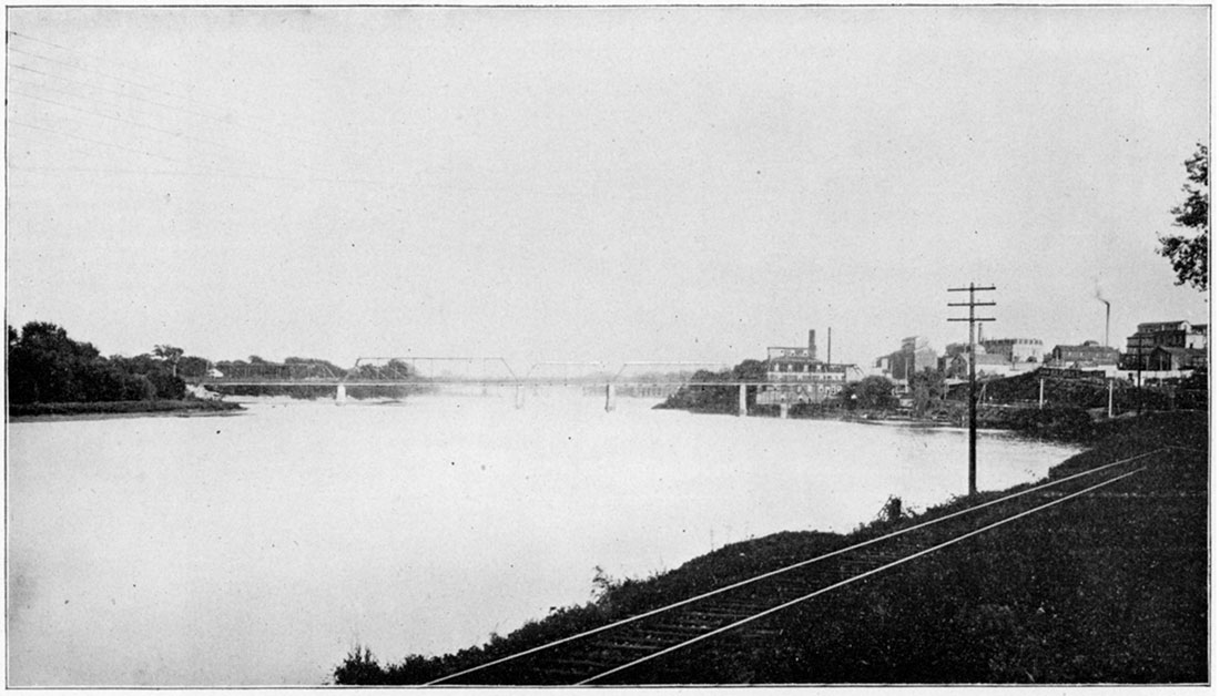
Plate XIX—Chautauqua Sandstone along the Wakarusa. (Photographed by Marcy, 1896.)
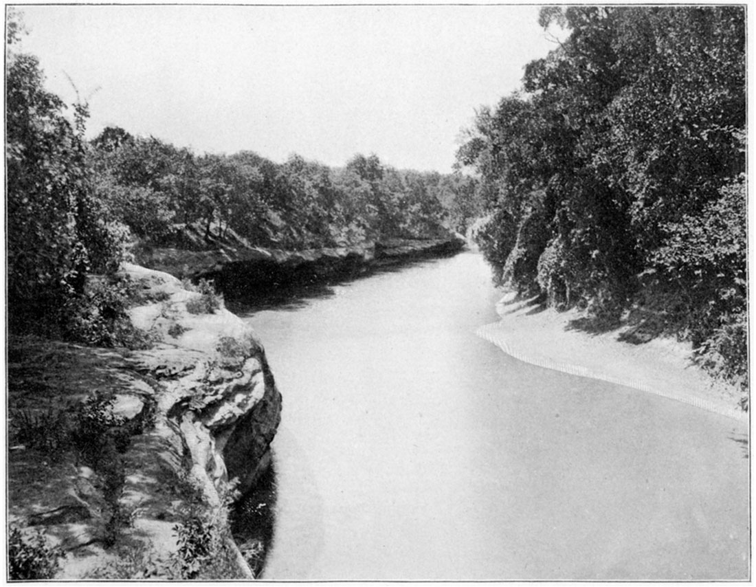
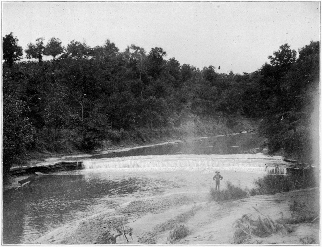
Plate XX—Osage Shales and inclosed thin limestone, Cedar Falls. (Photographed by Riederer, 1898.)
Remaining Formations
Above the Lecompton shales we have an alternation of shale beds and limestone horizons forming a terrane several hundred feet in thickness. No one of these limestones is specially prominent by itself or has specially important stratigraphic properties. The shale beds separating them likewise are comparatively thin and relatively unimportant. Their thickness varies greatly in different parts of the state and therefore the distance between the lines of outcroppings of the limestones correspondingly varies. In general in the southern part of the state the shale beds are thinner, bringing the limestones closer together, and producing thereby a set of terranes or escarpments not very high but close together. On the map, Plate VI, showing the outcropping of the different limestone systems three or more of these limestones are noticed outcropping near together west of the Oread limestone throughout Chautauqua, Elk, and Greenwood counties. The area between Greenwood and Shawnee counties has not been studied in sufficient detail to trace each of these limestones separately.
Northward the shale beds thicken and the limestones correspondingly appear on the surface farther apart. The individual limestones are correspondingly more easily traced and appear in the sections run by Hall and Bennett, as published in Volume I, Plates V and VI, to be more nearly distinct limestones than the same ones seem to be south of Greenwood county.
Doctor Adams's Field Work
During the summer of 1897 Doctor Adams studied Chautauqua, Elk, and Greenwood counties in considerable detail and prepared that portion of the map, Plate VI, on which the outcroppings of the several limestones are marked. Mr. Bennett, in Volume I, Plate VI, and accompanying description, has given a detailed account of a geologic section along the Kansas river.
The Osage shales have been traced from Topeka to the Neosho river and sufficient work was done between the river and Eureka to justify us in concluding that they also extend into Greenwood county, connecting with the heavy shale bed which is here and there coal-bearing throughout Greenwood, Elk, and Chautauqua counties. We therefore know that these formations extend across the state the same as others lower down.
The result of Adams's work in the south is expressed in the map, Plate VI; in the geologic sections, Plates I and II; and In the following description which is adapted from his field notes for 1897:
Elk Falls Limestone
Above the Lecompton shales throughout Greenwood and Chautauqua counties are two well defined limestone horizons separated from each other by a thin bed of arenaceous shales which here and there develops into wellformed sandstone. The thinness of the shale parting and the persistence of the upper limestone have resulted in the two forming practically the same terrace throughout the greater part of, this distance. This terrace is prominent just west of Elk Falls, from which place the limestones are named, from whence it passes southward with many deep sinuosities around the head of Salt creek, North Cana, Middle Cana, and Cedar creek, and leaves the state west of Elgin. It is seen very prominent at Rogers, about five miles west of Sedan.
Northward from Elk Falls it reaches up Elk river almost to Howard, veers eastward again on the highland between Elk river and. Fall river to the vicinity of Cave Springs, passes up Fall river by the way of Greenwood to within five or six miles of Eureka, then veers eastward on the highland between Fall river and Walnut creek, and again up Walnut creek to near Tonovay, making a line approximately parallel to the Osage escarpment already defined.The sandstone between these two limestones is particularly prominent in the vicinity of Cave Springs where both the upper and lower limestones may readily be seen, from between which the sandstone has been worn away, producing numerous recessions and caves .. The name Cave Springs originated from such a location and may be used to designate these particular sandstones.
Severy Shales
Above the Elk Falls limestone is a bed of shales averaging from 50 to 75 feet in thickness, which, with the protected limestone above, forms a light escarpment that may be traced from a few miles below Eureka to Cedar Valley, forming a line from two to five miles west of the Elk Falls escarpment. This shale bed is, therefore, sufficiently prominent to be recognized in the field and to be of considerable local stratigraphic importance. The town of Severy lies within it and therefore it may be called the Severy shales.
Howard Limestones
Above the Severy shales is a thin limestone, persistent from near Eureka to the south line of the state, but which nowhere is more than from 3 to 6 or 8 feet in thickness. In connection with the Severy shales it forms an escarpment as already described and which is readily seen lying a short distance west of the Santa Fe railway from Severy to Moline. South of Moline it bends westward around the upper tributaries of the various drainage channels, finally passing southward to Wauneta, thence southwest almost to Cedar Valley, and back southeast down Cedar creek and out of the state. North of Severy it passes west to Climax, then to within three miles of Eureka, thence above Tonovay two miles, and thence northeastward to beyond the limits of detailed field work.Osage Shales
Succeeding the Howard limestone is a bed of shales producing coal in several places. This seems to be an equivalent to the Osage shales, as it has been traced all the way from Chautauqua county northeast to beyond Topeka.
The coal is usually found about the middle of the shale bed and has a light limestone overlying it in most places. Mines have been opened at Eureka, near the head of Pawpaw creek; west of Howard, on Bluff creek; west of Moline; at Leeds, near Cedar Valley; and on the state line; but at present the most of these are abandoned. The coal varies considerably in quantity and is usually from 12 to 14 inches in thickness. At Leeds it is the most important. Mining here is usually conducted during the winter months.
Eureka Limestone
Above the Osage shales there is a limestone which serves as a protector and assists in the production of a permanent escarpment, reaching from Madison, in northeast Greenwood county, southward by way of Eureka around the heads of Honey creek and Tadpole creek, just west of Climax, between Severy and Piedmont, around the head of Pawpaw creek, to from four to six miles west of Howard, three or four miles west of Moline, by way of Cedar Valley, and around the head of Rock creek to the south line of the state.
Extracts from Bennett's Kansas River Section
Having studied the conditions in the southern part of the state let us now turn our attention to the conditions prevailing along the Kansas river. In Volume I, Chapter VI, Mr. Bennett has described the conditions which prevail from Lawrence to a few miles west of Topeka in great detail and has illustrated the same by Plate VI. From this chapter the following quotations are made, while Figure 2 is a reproduction of the part of Plate VI, from Lawrence to Topeka.
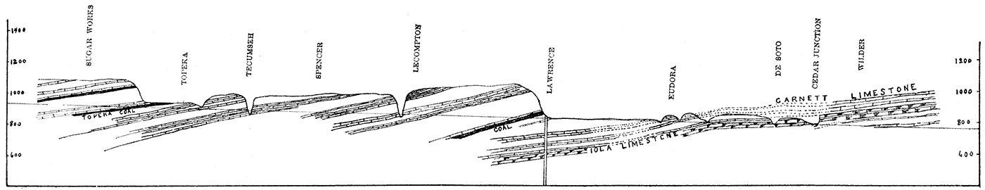
Figure 2—Showing succession of strata along the Kansas River from Wilder to Sugar Works. (After Bennett. From Plate VI, Vol. 1.)
Lecompton Limestones
Capping the hills around Lecompton is a 5-foot limestone in two layers, which we will provisionally name the 'Fusulina' limestone, not that it alone bears that fossil, but because of the abundance of Fusulina in it. It is the lower of another triple system of limestones, the members of which are separated by a few feet of shale, and which retain this order as far as observed to the west. Above the 'Fusulina' stratum are 5 1/2 feet of clay shales, then 1 1/4 feet of blue limestone which weathers dark buff like all its associate strata. Above this are 4 feet of shales having a bituminous streak in the middle, then 10 feet of light gray, easily disintegrated limestone. This group may be called the Lecompton limestone, on account of their outcropping being near Lecompton. At Spencer, six miles west of Lecompton, the upper of the series finally disappears below the alluvial soil of the valley.
"The fossils of the Lecompton series merit little attention except the Fusulina of the lower bed. In the top of a hill near Lecompton, where the lower member was greatly weathered, this little foraminiferous rhizopod lay in such profusion that it looked as though some farmer had emptied his wheat sack in the soils.
"Passing westward from Lecompton a slight difficulty was encountered in the correct understanding of the strata. The hills around Spencer were so covered with glacial material that the strata were principally concealed. One limestone was visible on a hilltop a mile south of Spencer, and which seems to dip westward and reach a relatively low position at Tecumseh. Two other limestones are also visible at Tecumseh, one of which forms quite a riffle in the river, and the other one of which lies below it and forms a floor to the river for some miles below. The glacial material is so abundant between Tecumseh and Spencer that an error might easily be made in the correlations, but it seems that the section above the Lecompton series is as follows, counting upwards: First the thin layer in the bed of the river below the riffle about 40 feet above the Lecompton system; then 4 feet of shales, and then the riffle rock 3 or 4 feet thick; then 25 feet of buff clay shales with small lenticular bodies of limestone throughout it; and then 2 feet of blue clay shales immediately under the top rock at Spencer above mentioned.
Deer Creek Limestones
"We now come to what we call the Deer Creek systems, the bottom one of which may be the limestone seen in the top of the hill at Spencer, and is seen at a few places southeast of Tecumseh. The Deer Creek exposure presents the following section, passing upwards:
"First, 6 feet of fossiliferous unevenly bedded limestone which was overlaid by 10 feet of shales, then a single-bedded limestone 2 feet, then 4 feet of drab and blue shales, and again 4 1/2 feet of limestone. These limestones were scarcely seen excepting in the Deer Creek exposures. They disappear altogether two miles or so east of Topeka. But above them in the tops of the hills, and separated by about 60 feet of slopes, are remnants of the system above, or the Topeka limestones.
"The organic remains were well preserved in the Deer Creek system, and the following genera and species were noted: Productus altonensis (?) (might be young of americana) were especially abundant. Bellerophon crassus were found here.
Topeka Limestones
"Coming now to the Topeka limestones, we find a quadruple series. In an exposure a mile east and a mile south of Topeka there is a showing of the upper section of the underlying shales. About 6 1/2 feet below the top of the underlying shales a fairly good building sandstone is reached which is 3 feet thick. The lower limestone of the Topeka system is 6 feet thick, and is blue but weathers dark buff. Above it is a foot and a half of blue shales, then above that 5 feet 8 inches of blue and brown limestone having a cherty layer near the top. Above this comes 2 feet of buff shales, and then again limestone 1 1/2 feet thick, above which are 3 feet of drab shales, which are again capped by 2 feet of limestone. The city of Topeka rests mainly above the cherty bed or second limestone of the series, yet here and there are fragments of the third or thinnest layer in place. The cherty bed has been extensively quarried by the builders of the city in the past and quarries are now being operated near Shunganunga creek in the south part of the city. The Santa Fe and the Missouri Pacific railroads have made a few exposures in the two upper limestones of the series just south of the city. In the various quarries a good opportunity was given to study the paleontology of the quadruple series. The fossils collected were: Fusulina cylindrica, Fistulipora nodulifera, Rhombopora lepidodendroides, Chaetetes and a romose unknown form of Chaetetes, Archaeocidaris ——, ——, Chonetes granulifera, Productus punctatus, Productus longispinus, Productus costatus, Productus prattenianus, Athyris subtilita, Spirifer cameratus, Streptorhynchus crassus, Terebratula bovidens, Retzia mormoni, Bellerophon carbonarius.
"The shales above the Topeka limestone could nowhere be accurately measured. At the brick-yard, three miles west of Kansas avenue, in Topeka, 28 feet of the upper part of the shales are exposed, and in a well close by we were told that 20 feet more had been penetrated before reaching the Topeka limestone. This would make them 48 feet thick, which we had good reasons for thinking was about correct. At the top of the shale lies 11 inches of coal, which has been mined in many places just west of Topeka, and which may be called the Topeka coal. Above it lies 2 1/2 feet of clay shales and then 2 feet of argillaceous limestone, then 6 feet more of shale, and again 2 feet of gray limestone. These limestones although thin were persistent for several miles to the west, where they and the underlying coal disappeared under the valley. The only fossils of any importance in this system were Chonetes granulifera, Fusulina cylindrica, a Productidae, and Crinoid columns."
"Four miles west of Topeka a section exposed in a railroad cut shows 26 feet of shales above the limestone system just described, and above them is a hard band of sand rock 2 feet thick which held its place until Lee's creek was reached, a mile and a half farther west. Beyond the creek at the sugar-works it was not seen. At the sugar-works, six miles west of Topeka, the coal and limestones above mentioned were all under the valley. Here the slope to the next limestone above was 91 feet from the Rock Island railway track, all of which seemed to be shales, but the exact thickness of the shales below the track could not be told. A reasonable approximation would put it at 25 feet, making a whole bed of 116 feet.
"At the summit of the last mentioned shale there is a foot of coal, and immediately above it 2 1/2 feet of limestone. "
Extracts from Hall's Osage River Section
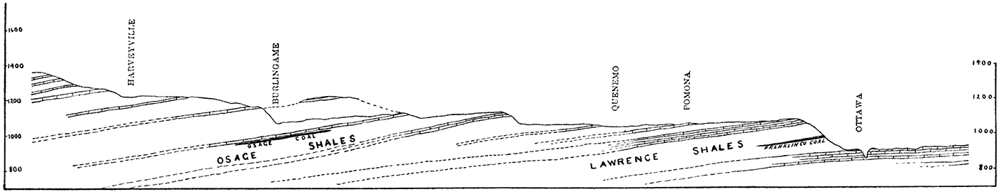
Mr. John G. Hall, at that time a student in the University, prepared Chapter V for Volume I, which report is accompanied by Plate V, showing a geologic section along the Osage river. Mr. Hall, although not a trained geologist, did his work under such supervision and proved himself to be so careful a student that reliance can be placed in his conclusions. It is important to note his section west from Ottawa to Burlingame which forms a line nearly parallel to Bennett's section along the Kansas river, but about thirty miles to the south. The following quotations are taken from Hall's report, and Figure 3 is an exact reproduction of a portion of his Plate V showing the conditions from Ottawa to Burlingame:
Figure 3—Showing succession of strata along the Osage River from Ottawa to Burlingame. (After Hall. From Plate V, Vol. I.)
Systems above the Oread Limestone
"The first limestone system above the Oread appears ten miles west of Ottawa, and is 4 feet thick, covering a shale bed 50 feet thick. The general appearance of the limestone is much like that of the Oread limestone and would make good building stone. The shales below this limestone are buff in color and are generally soft, and hence yield to the weathering agencies quite readily, but sometimes they turn into a brown sandy shale which is very coarse, instead of being composed of the fine particles that generally make up the shales.
"Following up the river another limestone, No.2, is reached a mile west of Quenemo, and is 5 feet thick, covering a shale bed of 20 feet. It is, composed of two layers of almost equal thickness and is of a grayish yellow color and quite hard. The shale bed has so many thin layers of sandstone, which are made up almost entirely of sand, that it wears away nearly as slowly as the limestones. The layers of silicious sandstone are none of them more than 2 or 3 inches thick, while most bf them do not exceed half an inch.
"Six miles to the northwest of Quenemo system No.3 crops out, which is 10 feet thick, the upper 4 feet of which is brown in color, while the rest is almost white. The whitish portion contains one layer about 1 foot thick which is composed of fossil Fusulina, the shells of which are about the size and shape of a medium-sized grain of wheat.
Osage Shales, Coal, and Limestone
"Six miles southeast of Burlingame system No.4 crops out, but can be traced only a short distance until it is lost to sight. It is 15 feet thick, and corresponds so closely with the one found under the coal at Burlingame, both in thickness and general structure, that there can be little doubt but that it is the same system. It is very soft, and therefore easily worked, but not used much on account of its softness.
"The coal found at Burlingame is from 75 to 90 feet below the surface of the ground, depending on the position of the shaft. There is a broad almost level strip of country extending over nearly the whole of Osage county, underneath which the coal is found. The coal varies in thickness from 18 inches to 3 feet. It is mined at Osage City, Scranton, Burlingame, and Peterton, and formerly was mined at Carbondale, but these mines have not been worked for some time. The whole country is dotted with coal shafts, some of which are worked only for private use, while the majority are worked and the coal put upon the market.
Burlingame Limestones
"Just west of Burlingame, system No.5 makes its appearance. It is 8 feet thick, is brown in color, shelly in character, and covers the third and last heavy bed of shales in this section. The shale bed is 150 or 200 feet thick, and throughout it are found thin beds of limestone which tend to cause the shales to resist erosion. Here, as with all other thick beds of shale, are a number of isolated mounds which are covered with limestone that corresponds in general so closely with that found on the main bluffs one cannot help believing they are the same system. These mounds are most numerous to the north of Burlingame, and differ in height from 50 to 125 feet. The most important one is about two miles from Burlingame and is 85 feet high, and covers an area of almost a square mile."
Correlation of Sections made by Adams, Bennett, and Hall
From the foregoing quotations and illustrations it will be seen that there is a close resemblance between the Kansas river section of Bennett and the Osage river section of Hall, and that there are along each section three principal limestone systems above the Oread limestone and below the Osage coal and shales. As the sections are but thirty miles apart and the similarity so great between them there can be no reason for doubting that they are the same.
During 1897 the Osage coals and shales were traced southward by Bennett to Lebo where coal has been mined, leaving no doubt but that the coals here are the same as at Osage City, Burlingame, Scranton, etc. Throughout its whole distance the coal lies to the east and below the heavy escarpment produced, as described by Hall and quoted above, by the Burlingame shales and limestones. This same escarpment passes to the southwest across the Neosho, occupying the hills just west of Madison, Hamilton, Utopia, and becomes the escarpment at Eureka which is protected by the Eureka limestone as described by Adams. The Osage limestone of Hall thins out and becomes unimportant, so that it cannot be used as a division line between the shales. The Osage shales, therefore, may be considered to extend upwards to the Burlingame limestone, including what Hall called the Burlingame shales. From both the lithologic and stratigraphic standpoint this is a natural classification, and would have been made in Volume I had we then possessed the necessary information.
Having correlated the Burlingame limestone of Hall with the Eureka limestone of Adams priority requires that the former name stand.
As there are practically the same number of limestone and shale beds between the Oread limestone and the Burlingame limestone all the way across the state, there can be no reasonable doubt of their connection; therefore, the nomenclature of Bennett in his Kansas river section, having priority, should stand. It has been followed in the general section of the Coal Measures in this volume, Plate VI. As the shales between the Lecompton limestone and the Deer Creek limestone have been named the "Tecumseh" shales by Beede (1898) that name is here adopted, as is also his name "Calhoun" shales for those first above the Deer Creek limestone.
General Resume of Coal Measure Stratigraphy
Having given in considerable detail the location and general character of each of the principal formations in the Coal Measures of Kansas a few general remarks applicable to the whole area may be of service in forming a correct idea of the Coal Measures of the state. From the detailed descriptions it will be seen that the Kansas Coal Measures differ in many respects from those of any adjoining states, at least so far as descriptions of the others have been published. The one great difference which has impressed itself upon the minds of all who have recently worked in this field is that the division line between the coastal and non-coastal formations does not exist here as it is reported to exist in Iowa and Missouri. Let us first consider how the coastal lines have migrated during Coal Measure time.
We find evidence of an emergence at the close of the Mississippian period sufficiently extended to bring into dry land form parts of Arkansas, Indian Territory, Kansas, Missouri, and Iowa, but how much of them it is difficult to say. The extent of the surface erosion resulting therefrom has already been described, and it was seen that there is little evidence favoring the view of extensive erosion west of the eastern limits of the Coal Measures as at present found. If, during this period, there was heavy erosion eastward, the sediment produced by such erosion must have been carried oceanward and deposited some place to the west and would be characterized by the nature of the materials eroded. It is true the subsurface conditions lying to the west have been studied but imperfectly, as they necessarily must be so long as the overlying strata conceal them. It is difficult to understand how an extensive erosion of the Mississippian limestone with its heavy flint beds as now known to exist on the surface could have taken place without the detrital material from the flint being carried oceanward and deposited as conglomerates. The surface of southwest Missouri and northwest Arkansas is now covered with gravel beds retained as residual products as the flint-bearing limestones have been eroded. These gravels are carried downwards in our streams for great distances, some of them even for hundreds of miles. If there was corresponding erosion between Subcarboniferous and Coal Measure times, it is difficult to understand why similar gravels were not carried oceanward at that period or left on the surface then existing to form conglomerates and gravel beds at the base of the Coal Measures as they now lie. Such gravel beds have not been found although dozens of deep wells have gone through the Coal Measures and for some distance into the Mississippian limestone. This negative evidence is not conclusive, but it must be admitted that it has a value, and so far as it goes tends to minimize the surface erosion between Subcarboniferous and Coal Measure times.
We may therefore conclude that at the beginning of Coal Measure time the coastal line lay to the eastward of the present eastern limits of the Coal Measures. How far, is the merest conjecture. At that time the gravel beds and conglomerates, already alluded to, probably were formed and have since been entirely destroyed by erosion, a portion of the gravel from which may now constitute the gravel beds so abundant in Arkansas and Missouri. Such gravel beds necessarily were formed in narrow belts along the ocean and therefore later when the Coal Measures were lifted to the surface and were eroded their easternmost extension necessarily would be eroded first and the narrow gravel beds destroyed. This view limits the westward recession of the coastal line and implies that previous to Lower Coal Measure time it had passed but little farther west than the present eastern limits of the Coal Measures.
The materials from which the Cherokee shales were made seem to have come from the east, and were detrital obtained from the breaking down of ordinary terranes. No feldspathic granules or boulders have been found anywhere within them, no micaceous or other fragments other than that ordinarily found in ordinary sandstones and shales. The great extent of the Cherokee shales north and south implies a like condition over a wide area. It is one of the peculiar and interesting facts throughout all America that the Coal Measures proper are composed of so nearly the same kinds of material. The Coal Measures of the Appalachians, however, and particularly the lower strata, contain many more conglomerates than are found elsewhere, and correspondingly show a different series of physical conditions which influenced their formation. But from Iowa to Arkansas throughout the whole distance the Coal Measures west of the Mississippi seem to be essentially the same throughout their lower formations, and seem to be sediments accumulated from sluggish streams draining a land area with but slight elevations, or deposited far out at ocean where none of the coarsest material could be carried.
At the close of the period during which the Cherokee shales were formed an oscillation of elevations must have carried the shore line farther to the east, as ocean water overspread the shales and limestones were formed. It is interesting to note that the uppermost parts of the Cherokee shales are so rich in carbon, producing the Fort Scott coal and the unusually black carbonaceous shales both below and above the coal beds. The first limestone formed is the Fort Scott cement rock which, as already seen, is different in its physical properties from any other rock known in the state. It seems to have been formed in a quiet ocean where a continual supply of the most finely ground shell detritus was intermingled with the finest silt.
Immediately at the close of the cement rock a thin bed of shale was formed which, like the first below, is characterized by an unusually heavy amount of carbonaceous material. Then follows the Upper Oswego limestone, or the Fort Scott coral rock as it is sometimes called. Here the ordinary oceanic conditions prevailed to a greater degree. Animal life was exceedingly abundant in the other localities where the limestone is now found, as is witnessed by the myriads of fossils it bears, and especially by the particularly large coral masses found from Oswego to Fort Scott and beyond, which plainly have never been moved from their places of origin. While the Cherokee shales gradually grow thinner to the west, these limestones on the contrary gradually thicken in that direction and we may reasonably suppose that the portions which have been removed by erosion to the east were thin her than those left to the west, that in an easterly direction they were formed in thinner beds, until, as the shore line was reached, they entirely disappeared. The great lateral extent of the Oswego limestones from north to south and from east to west indicates a similarity of conditions over hundreds of miles in extent.
The change from limestone to shale formation seems to have been sudden, for the upper surface of the Oswego limestone is as clearly defined as the lower. The conditions during the formation of the Labette shales were not so uniform as prevailed while the Cherokee shales were forming. We find more sandstone in places, and less elsewhere, the variations being greater and more marked.
While the Pawnee limestone was forming the conditions were more variable than during the formation of the Oswego limestones. The Pawnee does not have so great a northern extension, yet in the vicinity of Fort Scott they are thicker and heavier than the Oswego limestones at any place. It would seem that the limestone forming conditions did not prevail over the whole area in southeastern Kansas, or rather that they prevailed in a remarkable degree in the vicinity of Fort Scott and westward, while both south and north conditions were less favorable for the accumulation of limestone material, This irregularity of conditions is more marked than that found at any lower level in the Coal Measures of the state.
During the Pleasanton shale period the general physical conditions of the Cherokee shale period were repeated. The strong similarity between the general properties of the Pleasanton shales and the Cherokee shales is remarkable. No one could distinguish between them from any of their physical characters, excepting that the amount of coal in the Cherokee shales in places is a little greater than any that has yet been discovered in the Pleasanton shales. The large deposits of flagging stone are the same in the two. The heavy beds and thick layers of sandstone likewise are the same in the two. The abundance of ripple marks and wave marks is the same for the two. The variations from argillaceous to arenaceous and then to carbonaceous are the same for the two. If the physical properties of the one imply that they were produced near the coast subject to the variations of coastal deposits, then the same is true of the other. The great abundance of broad thin flags in the vicinity of Gilfillan, Redfield, and Bandera is a repetition of similar flags in the lower part of the Cherokee shales in the vicinity of Crestline and to the southeast of Columbus, while heavy beds of sandstone at the very summit of the Pleasanton shales at Boicourt and La Cygne are a repetition of the heavy layers of sandstone in the Columbus sandstone area. The great extent of the shales north and south and east and west is likewise similar to that of the Cherokee shales.
Here, however, there is a difference. The Pleasanton shales are thickest midway of the state, gradually growing thinner to the north, while the Altamont limestone bisects them to the south and even with this addition of limestone the sum total of the Lower and Upper Pleasanton shales and the Altamont limestone combined shows no greater thickness than the shales alone do in the vicinity of Boicourt and La Cygne. This sagging, so to speak, of the middle line of the state, with the filling in of the detrital material to produce the shales, and the absence of the Altamont limestone parting recognized farther south, implies a rapid accumulation of shale forming material and probably a proximity to a rapid drainage of the little continent lying to the southeast.
At the close of the Pleasanton shales period a great difference in the physical conditions throughout eastern Kansas was produced. Oscillations rapidly occurred resulting in a series of conditions favorable to limestone production. The heavy beds of Erie limestone resulted, which in many places aggregate more than 100 feet. Here again the conditions were not uniform through eastern Kansas. The center of the limestone formations seems to have been westward from Fort Scott, while both north and south from this position the conditions were not quite so favorable, and the limestones which resulted were correspondingly lighter. This is particularly true in the south where a series of conditions seems to have prevailed which are of the greatest importance. The limestone layers of the Erie limestone gradually grow thinner and the shale partings gradually grow thicker until we have the great series of the Mound Valley and Cherryvale shales separating the three members of the Erie limestone by an aggregate of about 200 feet. This decrease in the thickness of the limestone southward and the corresponding increase in the thickness of the shale beds can best be understood by assuming that in some way there was an unusually large amount of sediment brought in from the south. The coastal lines probably veered far to the southwest, producing dry land to the southwest in the Indian territory, so that the drainage was to the northwest or probably more nearly to the north throughout the greater part of this period, a condition which, although reversed later, again obtained during the period of the formation of the Lawrence shales. While the uppermost member, or the Independence limestone, was being formed the conditions were reversed. The Independence limestone is rapidly thickened from only a few feet at Cherryvale to thirty or more feet at Independence, ten miles away, showing that here the conditions were most favorable for the prolific growth of marine invertebrates and the accumulation of limestone forming debris. Likewise the deep wells further to the west at Neodesha and Howard show that the heavy Independence limestone increases in thickness even that far away.
Plate XXXI—Section through Arcadia.
The area, in other words, where the Erie limestones are least in quantity and where the shale partings are the greatest is in eastern Montgomery and northwestern Labette counties. The dry land area furnishing the sediments for these heavy beds of shale must consequently have lain to the south in the Indian Territory and the coastal lines during this period must have reached much farther to the southwest and west than at any previous time.
The Thayer shales which overlie the Erie limestones tell an interesting story of the physical conditions existing during their formation. Here we have a great shale bed which thickens to the south to beyond the southern limits of the state. They are more than 200 feet thick at Table Mound and along the heavy escarpment to the west of Independence, from which locality they gradually grow thinner to the north until within Linn county and Miami county and farther to the north through Johnson and Wyandotte counties they have almost lost their identity. This great thickening of the Thayer shales to the southwest again strongly indicates the proximity of a drainage area which was furnishing the unusual amount of material for shale production. The large quantities of sandstone within the Thayer shales tells the same story. This sand mass must have been formed near the shore and for their existence in the positions they occupy the existence of a heavy drainage from the south and southeast was a necessity.
Thus far in our history throughout the whole time subsequent to the Pawnee limestone formation the conditions have favored the great thickening of all the shale deposits to the south and southwest, while throughout the same period the limestones in general. have been heavier to the north and northwest, a combination of conditions which implies that the great oceanic area lay to the north and north west and the land areas to the south and southeast. The westward veering of the coastal line immediately at the close of the Pawnee limestone period is most marked and most important to the student of inter-Coal Measure geography.
With the ushering in of the period during which the Iola limestone was formed the conditions were practically the same as those just described. Along the southern line of the state where the Iola limestone outcrops it is relatively unimportant. The great bed of Thayer shales beneath with its easily eroded condition has caused erosion to wear away the Iola limestone to the west. This is particularly true in Wilson county where the limestone has been worn back, forming an embayment twenty miles further northwest than the position it should occupy as indicated by the normal direction of the outcropping of the Iola limestone. But the great thickening westward of the Iola limestone, as shown by the Howard well, the Toronto well, the Elk Falls well, and other deep wells to the northwest, shows that further back to the northwest, or further oceanward, the conditions were more favorable, and the limestone was formed to a much greater thickness. These properties of the Iola limestone similarly substantiate and confirm the views already expressed, that the coastal lines had migrated westward, and that the areas over which limestone forming conditions prevailed to the greatest perfection were further westward.
At the close of the formation of the Iola limestone the conditions so prominent were reversed and the overlying shales, the Lane shales, are gradually thickened to the north. In fact southward the Lane shales become thinner until south of the Neosho river they are scarcely discernible. Well records to the west along the southern part of the state show that the same conditions existed there. The Howard well and the Toronto well show less than half the amount of Lane shales that is found, to the northeast. This change of conditions must have been brought about by an elevation of the land area northward so that erosion was more rapid and debris more abundant opposite Garnett and Lane and Osawatomie than elsewhere.
The debris of which the Lane shales and the included sandstones are formed does not imply a rapidly eroding continent, but rather they are composed of the finer materials which have come from a continent of but slight elevation, and with drainage streams of mild velocities, similar to the conditions which must have prevailed throughout the formation of the shales lower down.
This excessive shale formation to the north lasted but a short time, for during the Garnett limestone period conditions, were more favorable for the production of heavy limestones northward than they were southward. The Garnett limestones are more pronounced and are much heavier along the Kansas river and south in the vicinity of Lane than they are along the southern line of the state. In fact southward from the Neosho river they can scarcely be traced on the surface, due partly to the thinness of the Lane shales and largely to their own unimportance.
Throughout the whole period from the Oswego limestone to the close of the Iola formation there was a general thickening of strata to the south and southwest. But here with the Lane shales and the Garnett limestone there was a corresponding thickening to the north which resulted in leveling up the conditions to a great extent ready for the Lawrence shales to be formed.
In some respects the Lawrence shales are the most interesting formations in the. whole Coal Measures. Being heavy to the north in the vicinity of the Kansas river, where they are fully 300 feet thick, growing thinner southward to the middle of the state, and then rapidly thickening beyond to a thickness of more than 800 feet along the southern line, they represent a series of conditions favorable for the formation of shales and sandstones unsurpassed in the whole of Coal Measure time.
The unusually large amount of sandstone irregularly scattered through them implies that the eastern borders of the shales as now exposed were not far removed from shore lines during their formation. This is particularly true on the south side of the Neosho river where the Chautauqua sandstone reached such enormous proportions, almost to the utter exclusion of argillaceous materials of any kind.
It would seem .that the coastal lines veered far to the west again and that the dry land area was lifted unusually high, producing an unusually rapid erosion with the production of vast quantities of sand, while the finer and lighter silts were carried beyond to the northwest. It is interesting here to note that the record of the Topeka well, and more emphatically the record of the McFarland well, elsewhere published in this volume, shows an excessive amount of shale with a correspondingly light amount of sandstone and limestone. It is not unreasonable to suppose that the great quantities of sand constituting the Chautauqua sandstones and the corresponding sandstones farther north in the vicinity of Ottawa and Lawrence and Leavenworth were simply the shore deposits, the finer sediments accompanying which were carried farther oceanward and formed the heavy shale beds passed through by the McFarland well.
The great abundance of ripple marks and wave marks in the sandstones of the Lawrence shales, from the south side of the state to the north, markings which not only surpass anything known in Kansas but probably equaling any found anywhere in the Mississippi valley, confirm the above view.
From the Oread limestone upwards to the Osage shales nothing of special importance exists, but the Osage shales are important for many reasons. The outcropping of these shales is about 120 miles west of the eastern limits of the lower part of the Cherokee shales as they now exist. The vertical distance of the shales between the bottom of the Osage shales and the bottom of the Cherokee shales is more than 2000 feet, as is shown by the deep wells at Toronto and other points/while the aggregate distance obtained by adding the thickness of the surface outcroppings is about the same, the decrease in the thickness of the shales being compensated by the increase in the thickness of the limestones.
The character of the Osage shales with their numerous sandstones and coal beds leaves no room for doubt but that the portions of them now exposed near the surface were formed near the shore. The argillaceous and arenaceous limestones which occasionally are found within the shales tell the same story. Many of them have reptilian footprints within, showing conclusively that they were formed under such conditions that the air-breathing animals of the time frequented the marshes and swamps in which the deposits were accumulated. As stated in Volume I, page 162, "Years ago Professor Mudge (1873) discovered many reptilian tracks in the shelly limestones at the quarries near Osage City. He purchased two car-loads or more of the limestones on account of their carrying so many tracks. He, shipped a large portion of them to Yale University from which Professor Marsh (1894) has recently identified them as being the tracks of Monopus caudatus and four or five other species."
The Osage shales in their entirety form a deposit fully 200 feet thick which extends across the state from the south line to the north, and probably for many miles beyond. They represent in their aggregate as conclusive evidence of their having been formed in coastal waters as did any of the Lower Coal Measure shales. The coastal lines therefore must have migrated westward in the aggregate fully 100 or 150 miles from the beginning of Coal Measure time to the close of the Osage shales time.
The position of the outcropping of the- several formations in the Kansas Coal Measures is interesting. Of course these lines are determined in their position largely by recent erosion which, in turn, is due principally to two factors, the nature of the formations eroded and the conditions of surface elevation and consequent steepness of surface incline. The former condition is dependent entirely upon physical conditions prevailing at the time when the formations were produced, the latter upon the sum total of orographic movements during subsequent geologic time.
According to the geologic maps of Missouri the eastern limit of the Coal Measures trends northeast and southwest in the ratio of 1.4 mile north to 1 mile east. The outcropping of the Oswego limestone in Kansas is a similar ratio of 2 to 1; that is, northward it bears 2 miles north to 1 mile east. The outcropping of the Erie limestone is similar with a ratio of 2 to 1, as is also the outcropping of the Iola. The Oread limestone veers a little more north with a ratio of 2.1 to 1, while the Eureka limestone at the top of the Osage shales has a direction of north and east at a ratio of 3 to 1. It will be seen that the outcroppings of these several limestone systems and likewise of the intermediate shales is remarkably regular upon the general average. Were shorter distances measured, so that the lesser variations could be determined, it would be found that they were considerable, for wherever a shale bed thickens the tendency is for the overlying limestone to recede farther to the west. In general, however, it is seen that the upper members of the Coal Measures have a tendency to approach a more nearly north and south line in their outcroppings. Were similar investigations carried higher into the Wabaunsee formation of Prosser and into the Permian it would be found that the line of outcropping approaches still closer to the north and south direction, due, without doubt, in the main, to the thickening of the Permian limestones in the south, giving them a greater resistance to erosion, and to the thickening of the inter-bedded shales to the north, giving them less resistance to erosion. This is the main feature in the production of the Flint Hills, at;t area in the southern part of the state which maintains an unusually high elevation with a very abrupt descent on the east. Had the several shale beds from the Mound Valley shales up to and including the Lawrence shales been thinner on the south this variation in the direction of the lines of outcropping, and likewise the unusual steepness on the eastern side of the Flint Hills, probably would have been avoided.
Comparison of Kansas Coal Measures with Coal Measures of Missouri and Iowa
It is impossible to make a detailed comparison of the stratigraphy of the Kansas Coal Measures with those of either Missouri or Iowa on the north, or of the Indian Territory on the south, on account of a lack of available detailed stratigraphic information outside of Kansas. There is a comparatively extensive literature On both the Missouri and the Iowa Coal Measures. But the student of stratigraphy who is searching after details of a definite character to use as above mentioned will be disappointed, No maps or charts are available showing the exact lines. of outcroppings of limestone systems in the Coal Measures of either state. [Since the above was written the writer has received, through the kindness of Mr. H. Foster Bain, a proof copy of Prof. Colvin's geological map of Iowa, for 1898. on which the line between the Des Moines and Missourian is represented for Iowa.]
The nearest approach to this for Missouri is the physiographic map by Marbut, Plate II, in Volume X of the Missouri Geological Survey. Marbut's Henrietta escarpment crosses from Kansas into Missouri just north of the Osage river. He says it is "formed by the outcropping of the Henrietta limestones of the Lower Coal Measures." Keyes [Dr. C. R. Keyes, 1897: Proc. Ia. Acad. Sci., vol. iv, p. 23, Des Moines.] says that this limestone corresponds to the Pawnee and Oswego limestones of Kansas. But the bluffs on the north of the Osage at the state line are capped by the Erie limestone, the Pawnee disappearing some miles to the south. It is not known whether Marbut and Keyes were mistaken in their identification of the limestones capping the bluffs north of the Osage river at the state line, or whether they meant to place the Erie limestone in the Lower Coal Measures. Keyes, however, is wrong in saying that these limestones correspond to the Pawnee and Oswego.
A strange feature of this Henrietta escarpment is that in Missouri, according to Marbut's map, it veers eastward, passing entirely across the Lower Coal Measures, and connects with the Mississippian outcropping in southwestern Pettis county, a condition which is entirely different from anything known in Kansas. With such conditions it is evidently quite unsafe to use this escarpment in stratigraphic correlations.
Marbut's Bethany escarpment, it would seem, corresponds in a general way with the outcropping of the Iola limestone, which crosses from Kansas into Missouri at the northeast corner of Miami county, Kansas, or about the middle of Cass county, Missouri. The low ground produced by the Blue river carries an outcropping line down to Kansas City, but probably the eastern limit of the Iola reaches eastward into Missouri, as is represented by the Bethany escarpment.
The heavy and prominent escarpment produced by the Lawrence shales and the Oread limestone, which is the greatest escarpment in Kansas, seems to have disappeared in Missouri, although it is very pronounced at Leavenworth. Neither do. any of the superior Kansas escarpments seem to appear in north Missouri, judging from Marbut's description of the Lathrop plain and the Marysville lowlands in northwest Missouri. It is quite probable that the northward thinning of some of the Kansas shale beds and the protection afforded Missouri by the mantle of glacial material are principally responsible for this difference of physiographic features. The thinning of the Thayer shales in the vicinity of Paola has brought the Iola limestone down so close to the Erie that the escarpment here is not so prominent as it is farther southwest. Should this thinning of the Thayer shales be continued into Missouri it would bring the Iola down so low that this escarpment would ultimately coalesce with the Erie escarpment. Marbut speaks of the Bethany escarpment at the state line being indistinct but becoming more prominent beyond. The above is probably the explanation for such a condition.
If the Kansas terranes at present cannot be traced northward across the state of Missouri with certainty it is much less possible to correlate them in any definite way with the Iowa, Coal Measures. Keyes [Dr. C. R. Keyes, 1892: Iowa Geological Survey, vol. i, p. 85, Des Moines] has divided the Iowa Coal Measures into the Des Moines and the Missouri formations, the division being based upon lithologic properties. He says [Dr. C. R. Keyes, 1892: Iowa Geological Survey, vol. i, p. 84, 85, Des Moines]:
"In considering the Coal Measures as a whole, two tolerably distinct classes of sediments are readily recognized: (1) the marginal or coastal deposits, and (2) the beds laid down in the more open sea.
"These two categories are sharply contrasted lithologically, stratigraphically, and faunally. The first is characterized by the rocks being predominately clay shales and sandstones, with practically no limestones. The individual beds have usually a very limited extent, and replace one another in rapid succession, both laterally and vertically. The sandstones often form great lenticular masses, sometimes deeply channeled on the upper surface, the excavations being filled with Coal Measure clays. These and many other phenomena attest a constantly shifting shore line and shallow waters. The fossils contained are nearly all brackish water forms or shore species. Remains of pelagic organisms are not numerous.
"On the other hand, the second class above mentioned is made up largely of calcareous shales, with heavy beds of limestone. The layers are evenly bedded; and extend over considerable distances. The faunas are chiefly composed of strictly open sea forms.
"As the conditions of deposition were evidently those of a slowly sinking shore, the marginal deposits as a whole practically underlie the deep sea formations, the former being regarded as the Lower Coal Measures and the latter as the Upper Coal Measures. At the same time it must be remembered that this does not necessarily imply that the lower measures are to be considered as much older than the 'upper,' but rather that along the great and successive planes of sedimentation different beds of the upper and lower divisions were laid down contemporaneously.
"While the general divisions of the Coal Measures may be readily recognized, it does not seem advisable to draw an exact line of demarkation between the two formations until the evidence of the faunal studies already begun has been fully taken into consideration and a comparison of the different methods of solving the problem is made.
"With this idea of the Coal Measures of the interior basin, the limits of the two formations in Iowa assume somewhat different lines of separation from those which have been commonly recognized.
"It is proposed, therefore, to divide the 'Upper' Carboniferous, or Pennsylvanian series; into:
"(2) The Missouri.Stage.
"(1) The Des Moines Stage.
"The Des Moines formation represents the lower Coal Measures, or the marginal deposits of the upper Carboniferous; It takes its name from the Des Moines river, which flows for more than 200 miles directly through the beds of this terrane. It extends into Missouri, and follows the northern and western boundaries of the Ozark uplift into Kansas and Indian Territory.
"The Missouri terrane corresponds essentially with the upper Coal Measures, representing the more strictly marine beds. It is the formation typically developed in the northwestern part of Missouri. The Missouri river also winds its way for more than 400 miles through the beds of this stage, exposing numberless fine sections on both sides of the stream throughout the entire distance."
In subsequent reports of the Iowa Survey little that is more definite as to boundaries of terranes has been given. In Volume III, Prof. J. L. Tilton, in describing a cross section from Winterset to Ford, publishes a chart from which it would appear that at about one-fourth of the distance from Bevington to Winterset a heavy limestone appears, reaching westward to beyond the limits of the chart. In speaking of this limestone he says, page 138:
"If, along the line of the general section, there is encountered a heavy limestone formation whose outcrop can be readily traced northwestward into Guthrie county and southward into Missouri, connecting with a very similar limestone .which has been recognized near the northern boundary of the state, a clear and natural line of demarkation is obtained for separating the Iowa Coal Measure area into two distinct districts, one, made up mostly of shore or swamp formation in which coal was abundantly formed (Des Moines terrane), and the other composed chiefly of more strictly marine beds (Missouri terrane). This is the first important limestone above those of the great Carboniferous basement."
Later in Volume V, 1895, page 23, Tilton says:
"In the cross sections along Middle and South rivers it will be seen that the limestone of the Missouri stage does not change into shale as would be true if the 'lower' Coal Measures (Des Moines stage) were the shore equivalents of the present exposures of the Missouri limestone. While it is undoubtedly true the present exposure of the Missouri limestone did have a shore equivalent of shale, when the limestone was deposited, that old shore equivalent has been eroded. The shales of the present Des Moines formation are now continued underneath the limestone of the Missouri stage."
But where this division line between the Des Moines and the Missourian would fall in Kansas is hard to determine. From the descriptions given in different places by the Iowa and Missouri geologists it would seem that it might be anywhere from the Oswego limestone up to the Iola. Tilton's description and chart for Iowa, Volumes III and V, seem to put it at the Oswego, while Keyes and Marbut as already seen in their location of the Henrietta escarpment and the Bethany escarpment, class the Erie in the Lower Coal Measures, and appear to make the base of their Bethany limestone correspond to the base of the Iola, although elsewhere Keyes expresses different views.
It seems that after the heavy deposits of the Cherokee shales and corresponding formations were made throughout Missouri and Iowa, whatever they may be, conditions for a time were more favorable for the deposition of limestones, and that a large amount of limestone was produced. But how many of these limestone horizons are individually continuous from the south line of Kansas through to central Iowa can be determined only by the most detailed field work in actually tracing the outcroppings of the individual horizons. The succeeding heavy shale and sandstone formations, so prominent in Kansas, seem to have no equivalents in Iowa. Our heavy Thayer shales and sandstones of marginal origin, our Lawrence shales with the included Chautauqua sandstones, the heaviest shales in the state and the ones showing the strongest indications of coastal origin, and the heavy and interesting Osage shales, all seem to have lost their significance and importance in Iowa, or to have been so covered up. by the glacial deposits and the Cretaceous formations, that they have not been recognized. Everything considered, it would seem advisable to be cautious about attempting exact correlations of a detailed character over so wide a territory. Presumptions may prove to be correct, but they should be held only as working hypotheses until verified in the field. For }he present, therefore, it seems desirable to retain the correlations as we know they exist in Kansas and refer to them only as a probability in the territory beyond.
Thickness of the Kansas Coal Measures
This report is confined to such portions of the Kansas Coal Measures as lie below the summit of the Osage shales. The Wabaunsee formation of Prosser, occupying a position between the summit of the Osage shales and the Cottonwood limestone, which Prosser has made the summit of the Coal Measures, will measure approximately 500 feet. In Volume I an estimate was made of the thickness of the whole Coal Measures and a chart, Plate XXII, was published showing the relative distribution of the different kinds of rocks composing them. At the close of this season's work, after much of the ground has been gone over and more detailed examinations made, another estimate has been made and Plate VI is a diagrammatic representation of this estimate. We now estimate the total thickness of the Coal Measures from the top of the Osage shales to the bottom of the Cherokee shales at 2,358 feet, with the different kinds of rock distributed as shown in the diagram. Of this amount it is found that limestone constitutes about 525 feet, and shale and sandstone combined 1,825 feet. The ratio, therefore, of limestone to the whole thickness is 1 to 4.5 nearly, or of limestone to shale and sandstone, 1 to 3.5.
It should be understood in considering this statement that the above estimates are made for what seems to be the average for the whole eastern part of the state. The different individual formations vary so in thickness from place to place that perhaps no one locality could be found where the conditions would correspond exactly to those just given. For example, at La Harpe the bottom of the Iola limestone is a little less than 1,000 feet above the bottom of the Cherokee shales, but the Thayer shales, Cherryvale shales, and others, thicken so much to.the south that the distance from the bottom of the Cherokee shales to the bottom of the Iola limestone is greatly increased. The Neodesha well reached the bottom of the Cherokee shales at 1,063 feet, although it started fully 200 feet below the bottom of the Iola limestone. West of Independence different wells have been put down 1,100 feet or more without reaching the bottom of the Cherokee shales, although they started 200 feet below the bottom of the Iola limestone. It is probable that the distance between the Mississippian limestone and the Iola limestone where the latter crosses the south line of the state is fully 1,400 feet, while west from Fort Scott it is not exceeding 950, and further north it is probably less. The varying thickness for other formations would make a variation for particular localities not exhibited in the general section as above given. But on the whole it may confidently be stated that these general figures are about as nearly correct as can be given. The+redeterminations of the thicknesses of various formations since the publication of Volume I have not materially modified the results.
Divisions of the Kansas Coal Measures
In Volume I it was suggested that the Kansas Coal Measures be divided into two divisions, the Lower and Upper, with the summit of the Pleasanton shales as the division line. Subsequent investigation has not materially altered this idea. For reasons therein expressed the summit of the Pleasanton shales is a natural division line between the beds below and those above. However, it is not the only natural division line which may be found. The Lawrence shales have proved to be so permanent and stand out so clearly separate from the formations either above or below that they, likewise, form a permanent natural division line between the formations below and above. In fact they are distinct lithologically and stratigraphically from those either above or below. Likewise the Osage shales form a tolerably distinct demarkation from the strata above or below.
There is a question as to how great an extent convenience would require divisions to be made. Prosser has already proposed the name Wabaunsee for all the Kansas Coal Measure beds lying above the Osage shales, and has subdivided the Permian in a similar manner, giving similar names to their divisions composed of different beds of limestones and shales. With a thickness of nearly 3,000 feet of Coal Measures in Kansas it is clearly evident; that for many reasons other subdivisions might be convenient.
The older custom of many geologists in dividing the Coal Measures into the Lower and the Upper, or Lower, Middle, and Upper might serve the purpose here, but with these divisions it would be somewhat difficult to decide where the division lines should be made between the Middle and Upper. Further, with such a method it, would be desirable at least to attempt a correlation of the Lower, Middle and Upper divisions with those formerly proposed in other states. Such a correlation would be difficult, and the attempt hazardous if not dangerous on account of the lack of detailed stratigraphic knowledge between Kansas and other localities. Three general divisions, however, might be made, using the Lower Coal Measures as already outlined, and allowing the upper surface of the Lawrence shales to mark the division between the Middle and the Upper. Almost equally strong argument, however, could be used to show the desirability of placing the division line between the Middle and the Upper with the Osage shales, placing all the non-coal bearing strata in the Upper division, Not being able, therefore, satisfactorily to use the older terms on account of the inability to correlate these three divisions with those located elsewhere, it is thought best to retain the division of Lower and Upper as previously used, and to subdivide each of them to whatever extent seems desirable. Accordingly the following scheme is suggested which may serve a purpose, and which may be retained for local use should it ever become desirable to resort to the older divisions of Lower, Middle, and Upper.
The Lower Coal Measures may be divided into two divisions, and the Upper Coal Measures into five.
The Cherokee shales stand out so prominently that they will be left in a division to themselves, retaining their former name.
The upper division of the Lower Coal Measures may include everything above the Cherokee shales and below the top of the Pleasanton shales. That is, it may include the Oswego limestones, the Labette shales, the Pawnee limestone, both the Lower and Upper Pleasanton shales, and the Altamont limestone. As the Marmaton river crosses this formation almost at right angles, and has cut its channel into the upturned edges of them, revealing a good section of them from base to summit entirely within the state, the name Marmaton formation will be given, with stratigraphic limits as just outlined. [It may be noted that the Marmaton formation as above given includes the "Pawnee Limestone Series" of Swallow, but more too, and the "Henrietta Limestone" of Marbut, as defined by Keyes—Proc. Ia. Acad. Sci., vol. iv., p. 23. 1897—;Marbut did not define this term, but as explained by Keyes it embraces the Pawnee limestone, the Labette shales, and the Oswego limestone. Here the name Marmaton is given, not to replace these, but because there is a demand for such a term, covering everything above the Cherokee shales and below the Erie limestone.]
In the Upper Coal Measures below the Lawrence shales are found, counting from the base upwards, the Erie limestones with their several shale partings; the Thayer shales; the Iola limestone; the Lane shales; and the Garnett limestones. This division is well limited stratigraphically by the Pleasanton shales below and the Lawrence shales above, so that anyone at all familiar with the stratigraphy of the country can easily locate the division lines. Here again we have a stream, the Pottawatomie river, almost entirely crossing this formation. The name Pottawatomie may, therefore, be given to the group of strata limited by the Pleasanton shales below and the Lawrence shales above.
The Lawrence shales are so distinct in character and, in connection with the Oread limestone overlying them, produce so prominent an escarpment, which extends entirely across the state from Leavenworth to the southern line, that they, with the overlying Oread limestone, may well be grouped in one general formation. It will be composed of the Lawrence shales with their included limestone and the Oread limestone, to which the name Douglas formation may be given, in allusion to the historic county of Douglas located largely within their limits.
From the Oread limestone upward to the summit of the Osage shales we have another series of alternating beds of limestones and shales which in general characterization are decidedly similar. This whole series may be grouped together in one formation, to which the name Shawnee may be given, in honor of the county containing the capital of our state.
Prosser having already given the names Wabaunsee and Cottonwood to two formations which include all the Coal Measures above the Osage shales these names will be adopted here as applying to the uppermost general divisions of the Kansas Coal Measures.
The whole of the above outlined scheme is represented in a table printed on the next page.
Table II—Divisions of the Kansas Coal Measures.
| B. Upper Coal Measures |
7. Cottonwood Formation | Cottonwood Shales Cottonwood Limestone |
| 6. Wabaunsee Formation | A series of alternating limestones and shales to which individual names have not yet been given. Burlingame limestone. |
|
| 5. Shawnee Formation | Osage Shales Topeka Limestones Calhoun Shales Deer Creek Limestone Tecumseh Shales Lecompton Limestones Lecompton Shales |
|
| 4. Douglas Formation | Oread Limestones Lawrence Shales |
|
| 3. Pottawatomie Formation | Garnett Limestones Lane Shales. Iola Limestone Thayer Shales Erie Limestones |
|
| A. Lower Coal Measures |
2. Marmaton Formation | Upper Pleasanton Shales Altamont Limestone Lower Pleasanton Shales Pawnee Limestone Labette Shales Oswego Limestones |
| 1. Cherokee Shales | Cherokee Shales |
Nomenclature Employed
Nomenclature, coupled with claims of priority, is the bane of the scientist. In the true sense of the term it is almost impossible for anyone to introduce new names without being liable to do an injustice to his predecessors. The history of science is filled with contentions for priority and struggles to avoid obscurity. The science of Geology is particularly unfortunate along these lines, perhaps more so than any other science: The earliest names applied to the great divisions, the Primary, Secondary, Tertiary, and Quaternary are almost gone. Likewise the term Azoic, everywhere employed in its day, had to yield to the inevitable and became obsolete on account of a discussion regarding the existence of a questionable fossil. In more recent times similar events have occurred, names suggested by geologists have been ignored by their contemporaries and successors, causing grief to friends and filling our literature with thousands of pages of acrimonious discussions.
It frequently happens that an investigator in a new field knowingly substitutes new names for old, sometimes with good reason, and sometimes apparently largely to have his name connected with future discussions of allied subjects. At other times, wholly unintentionally; names are ignored, sometimes because they are not in common use, or are meagerly published in out of the way documents difficult of access; sometimes on account of an inexcusable ignorance of the subject at hand on the part of the writer; but not infrequently on account of the unsystematic manner in which names have been applied and correlations made, compelling the new investigator to discontinue some of the terms and making it desirable, if not necessary, for him to introduce others.
The literature connected with the Trans-Mississippian geology has witnessed many instances in recent times falling under one or another of the above mentioned. categories. Attempts have been made to change the nomenclature of the whole Carboniferous. The old and well established name Sub-Carboniferous would be replaced by the new name Mississippian, and the well known name Coal Measures likewise by the new term Pennsylvanian. To a great. extent the detailed nomenclature of the subdivisions of the Sub-Carboniferous, or Mississippian, has been remodeled with a retention of but a few of the older terms, and the introduction of new ones. Likewise the widely employed division of the Coal Measures designated by the well known terms Lower, Middle, and Upper have been relegated to obscurity and new geographic terms, the Des Moines and the Missourian, substituted in their stead. Not only this, but one writer has even ventured to suggest that the name of worldwide recognition, Permian, be laid aside and an American geographic term, the Oklahoman, be used in its place. In this way the whole of the Carboniferous, recognized alike in the Old world and the New, would have its great divisions known entirely by American geographic names suggested by American geologists to replace older names for the same subdivisions.
At this point in our nation's history it may seem a little less patriotic to adhere to the older terms and to refuse to accept the newer and strictly American geographic names. But if the former can be ignored, doing violence to all the rules of nomenclature known to science, or the latter accepted, merely on the suggestion of recent geologists, where can there be a stability to geologic nomenclature?
The Kansas Survey has accepted the term Mississippian and has used it throughout all of its publications thus far issued. But it must be confessed that the writer of this has grave apprehensions that the last decade has witnessed a disregard for the laws of nomenclature as generally adopted by investigators in other departments of science, and that American geology will suffer as a result. If the inter-continental members of the great geologic column are not sufficiently important to require the retention for them of long-established and well-known terms applicable the world over, then they should be given provincial or local names which do not imply any relation or position in the geologic column with the great divisions elsewhere in America and in the world. Otherwise there are many reasons for holding that the modern departure, as a whole, is in general objectionable.
Coming now to more specific examples of Kansas geology, it may be stated that the nomenclature employed in this volume, and in preceding ones, in some respects is open to a portion of the criticisms above offered. On the other hand there are some conditions which, in a measure, render it necessary partially to ignore names formerly applied by other geologists. For more than forty years Kansas has been a favorite field for geological excursions. The old veterans, Meek and Hayden and Hawn and Newberry and Swallow and Broadhead and Mudge and St. John and Hay have traveled across the state in different directions, have written papers on this and that phase of Kansas geology, and brought the state into prominence as a rich field for paleontologists and stratigraphers who, in a broad way, are studying the general paleontology and stratigraphy of the great Mississippi valley. It is here that the Permian was first found in America, and it was from Kansas localities that those excellent yet general discussions of the Permian and underlying formations were made in early days by Meek and Hayden, and Swallow and Hawn. Geologic sections were made at Leavenworth, along the Kansas river, diagonally across the state to the Arkansas, and in various other directions here and there crossing the state in many places and covering, in one sense of the term, almost the whole of it.
Yet with all these preliminary excursions it was found that little had been done in the Coal Measures of the state to give a connected and systematic description of the individual horizons as they are now known to exist. In some of the sections the different terranes were merely numbered, no names whatever being applied. In other cases in which sections were run, with an attempt to correlate strata with those known elsewhere, the names were applied from other parts of the state, but the correlations were imperfect and dissimilar strata were given the same geographic name. In some instances this was found to be true even to the extent of discrepancies from 300 to 400 or 500 feet vertical distances, making it absolutely necessary that the whole of the correlations be gone over, some names discontinued, and others altered or changed.
With these conditions confronting us and becoming more apparent as work progressed it became desirable first of an to run a comparatively large number of sections from east to west; crossing the lines of outcropping of the Coal Measure formations to determine definitely what there was to, be of service in subsequent correlations of the different strata. Accordingly during the season of 1893 sections were run along the Neosho and Verdigris rivers and along the A. T. & S. F. Railway from Cherryvale to Lawrence, and a preliminary report of the same published in the January number of the Kansas University Quarterly of 1894. In this report local names were given to the various limestone and shale formations encountered and such correlations were made as at that time seemed probable between the formations along the different sections.
The following season further work was done over substantially the same area. A section was run along the southern line of the state from Galena to Grenola; one in a north and south direction from Baxter Springs to the northern side of the state; the Neosho river section was reexamined; an east and west section was made from Fort Scott westward to near Yates Center; a section was run up the Osage river from the east line to Alma; the section along the Santa Fe from Cherryvale to Lawrence was reexamined; and an additional section was run westward from Atchison along the Missouri Pacific railway. In addition to these sections a great deal of work was done in actually tracing the line of outcrop pings of the more important limestones, by following them mile by mile across the country. It was thought advisable to publish the results thus far gained, although it was recognized that some of the conclusions reached were only tentative. Accordingly a brief summary was published in the April number of the Kansas University Quarterly of 1895, and Volume I of the University Geological Survey of Kansas appeared early in 1896, the copy being completed in 1895. In the latter the details of these various sections were given both by word and by charts drawn to an exact scale. A reconnaissance geological map was likewise published and each of the supposed lines of outcroppings of the various limestones was represented. During the summer of 1897 this stratigraphic work was entirely reviewed in the field, principally by Mr. Bennett, Doctor Adams, and the writer, each of whom had previously done a considerable portion of the work for Volume I. It was found that in a few cases previous correlations had been erroneous. This gave rise to the necessity of changing slightly the nomenclature previously employed.
Since the publication of the preliminary reports, above referred to it has been learned that some of the names, therein employed had been otherwise used. In 1893 Jenny (1893, p. 55) suggested the name Cherokee limestone for certain limestones in the Subcarboniferous in the southeast, Before his paper was published the name. Cherokee shales was suggested by the writer and was used by different members of the Survey, but was first published by us in January, 1894. At that time Jenny's paper had not yet reached this office, probably due to no fault of Mr. Jenny. At the present time the name has appeared as widely in print referring to the shale bed as it has to the limestone. As the term "Cherokee" is only a part of the name, the remainder specifically describing the lithologic character of the horizon referred to, there may be no objection to its continuation. It is therefore retained.
The name Oswego limestones likewise first appeared in print in the Kansas University Quarterly in January, 1894, but had been used by the members of our Survey at least six months previous. The only objection known to the writer to such an use is in the possibility of, doing an injustice to Professor Swallow who, in his report in 1866 referred to each member of the Oswego limestones by separate name. The lower of the two he named the Cement rock and the upper the Fort Scott limestone. It was not until the season of 1895 that the correlation of the Oswego limestones in the Neosho river section and the Cement and Fort Scott limestones of Swallow was definitely established. There seems to be no objection to the use of the name Oswego limestones for the group, the two individual horizons being always separated by a definite and characteristic bed of shales. In our stratigraphic work it is found desirable to group the two under one name on account of their outcropping along the same line and being thus definitely associated. This usage need not prevent the use of the terms as Swallow employed them in 1886. Frequently his specific designation is desirable and may be continued.
The shale bed above the Oswego limestone seems not to have been named previously. At Doctor Adams's suggestion it will be called the Labette shales.
The limestone next succeeding was named the Pawnee limestone by Swallow in 1866 (p. 24), which term is retained.
Above the Pawnee limestone are the heavy shale beds previously called the Pleasanton shales, a name which is now retained with slight modifications as explained later.
In the first instance of obvious erroneous correlations, as mentioned above, the Altamont limestone of Volume I was found to be the 8-foot limestone system described by Bennett in Chapter IV and represented in Plate IV as lying nearly a hundred feet beneath the Erie limestone. The error of correlating this with the lower member of the Erie limestone, which at Kansas City is known to correspond with Broadhead's Bethany Falls limestone No. 78, was thus discovered. The name Altamont may, therefore, be retained for this particular limestone, which seems to have no importance except in the southern part of the state. The presence of this limestone beneath the Erie makes it necessary to modify the name Pleasanton shales previously applied to the shale bed lying between the Pawnee and the Erie limestones. As the Altamont limestone is a wedge-shaped mass prominent in the south but disappearing northward, causing the Pleasanton shales to bifurcate southward, it is thought best to retain the name as previously used for the northern part of the state, and to prefix the adjectives Lower and Upper in the southern, which thereby become local names.
Regarding the Erie limestones recently much has been written. Our Survey has demonstrated, we think, that the lower member of this series corresponds with the Bethany Falls limestone of Broadhead. It must be confessed, however, that there is room for doubting this proposition. In the bluffs at Kansas City, the southernmost point where Broadhead definitely located his Bethany Falls limestone, there are eight distinct limestone beds within 225 feet. The lowermost one, 20 feet thick, is the Bethany Falls rock of Broadhead. Southward these gradually decrease in number until west of Fort Scott, where Bennett described them in detail in Chapter IV of Volume I, there are but three principal limestones. Here the lowermost one of the three is 22 feet thick. Above this is a shale bed 7 feet thick, then 3 feet of limestone, then four feet of shale, and next a 16-foot mass of limestone. Above this heavy limestone there is a 9-foot shale bed, and then limestone 1 1/2 feet thick, then 3 feet of shale, and lastly a heavy limestone 25 feet thick. These three limestones, the 22-foot one, the 16-foot one, and the 25-foot one, are the principal members which seem to extend southward to beyond the limits of the state. What has become of the other five members existing at Kansas City, and what these lesser intermediate limestones here amount to is not known, and can be determined only by the greatest amount of detailed work in tracing their outcroppings, a task which would have no special value and which would be so great that it probably never will be undertaken. Now the eight limestones at Kansas City outcrop practically along the same line southward and they en masse have been traced southward to the locality of the above section by Bennett, so that we know that they are continuous, but no one can say that this lower 22-foot bed of limestone is the Bethany Falls limestone of Broadhead, although it probably is.
On account of the uncertainties as above expressed and still further on account of the thickening of the shale partings which reach 100 feet or more in Labette and Montgomery counties, convenience demands that local names be given to these heavy shale beds and to the thin limestones lying between, them. For that reason the names Mound Valley shales, Mound Valley limestone, Cherryvale shales, and Independence limestone are here retained with the understanding that they are for local application and need not be brought into the discussion of the wider application of other names.
In 1895 objection was made to the use of the term Erie limestone (Dr. C. R. Keyes, 1895: Am. Jour. Sci. [4], vol. I, p. 243) and a suggestion made that the term Bethany limestone be .employed in its place. At the same time it was suggested that the Bethany Falls limestone of Broadhead, which constitutes the lowermost member of the Erie as they occur at Kansas City, is continuous northward with the lowermost limestone at Winterset, which was long ago called the Winterset limestone. Regarding the objections to the term Erie it may be said that they do not appear insurmountable, and are no greater apparently than might be raised to the use of many other terms. Keyes's introduction of the term Bethany as a group name dates nearly two years later than the introduction of the term Erie; and cannot replace it, according to the laws of priority, on that account. His use of the term is entirely different from that of Broadhead's term Bethany Falls limestone, the former being applied to a group of limestones and the latter to one specific limestone. The absence of a definite statement of the upper limit of the Bethany of Keyes adds to the difficulty of adopting it in Kansas. If it comprehends the Erie, the Iola, and the Garnett, there are serious objections to its use here for stratigraphic reasons. The term Erie is definitely applied to a definite limestone horizon, and, for the present at least, should be retained.
If the time ever comes when we can have traced these individual limestones consecutively from southern Kansas to central Iowa adjustments can readily be made so that the exact correlations over such great distances will be accompanied bya proper use of terms, governed by the laws of priority.
Above the Erie limestones is the bed of shales, so heavy to the south, to which the name. Thayer shales has been given, and which may be retained.
During the past season Doctor Adams found two or more lesser limestones lying near the summit of the Thayer shales which in local areas were relatively prominent. One of these he has dignified by a local term, the Earlton limestone. Likewise, to the shale bed between this and the overlying Iola limestone he has proposed the name Vilas shales. Each of these terms is looked upon as strictly local on account of the local character of the beds named.
Next in the ascending order, that prominent and persistent limestone horizon is reached which in 1894 was named the Iola limestone. At Kansas City this seems to constitute a part of the calcareous aggregate to which Keyes has applied the name Bethany limestones. Keyes's descriptions and limitations, however, are so general in character that no one can affirm. or deny whether this be true or not. If it be true, then his term should not be applied in Kansas stratigraphy. For the Iola limestone is so widely separated from the Erie vertically and horizontally along its line of outcropping that it would be inconvenient and undesirable to extend the term so far. Throughout our whole state the Iola is much more intimately related with the overlying Garnett limestones than with the underlying Erie.
The Garnett limestones likewise appear in the bluffs at Argentine. Keyes has nowhere told us whether he would also include them under his term Bethany or not, and we are left to conjecture regarding this. Should he do the latter we will have still greater trouble, for they outcrop westward much farther away even than does the Iola.
The use of the term Lane shales to designate the shale bed between the Iola and Garnett limestones will be retained, as the name is applicable, and no objections seem to exist.
Regarding the limestones overlying the Lane shales some explanation should be given. When Kirk ran his section up the Neosho river in 1893 these limestones were temporarily called the Burlington limestones, but as it was then thought they were the same as the limestones in the vicinity of Garnett and eastward the double name was given, Burlington or Garnett. Later the latter term only has been used in reference to them, as it was deemed advisable to use but one. A difficulty has arisen however, by an erroneous correlation. It was thought that a limestone existed, between the Iola and the Garnett, which was prominent in the vicinity of Carlyle, and which therefore was provisionally named the Carlyle limestone. This error was not discovered until the season of 1897, when Bennett found that the so-called Carlyle limestone and the Garnett limestones were the same. It is therefore incumbent to make a choice of names. As the two were suggested in the same paper priority does not apply. But as the term Garnett has been far more extensively used both in the charts and maps and in verbal descriptions it would seem desirable to retain it and to discontinue the term Carlyle.
A somewhat similar difficulty exists regarding the use of the term Lawrence shales. The name Leroy shales was applied in 1894 to this heavy shale bed in describing the Neosho river section, while in the same paper the term Lawrence shales was applied to the shales around Lawrence. At that time it was impossible to correlate the two, but now we know they are the same, and therefore one name must be dropped. Here, as before, it seems desirable to use the term which has appeared in print the most frequently, and has been the most extensively used in cartography. The term Leroy shales is therefore discontinued and the name Lawrence shales adopted.
The name Oread given to the limestones covering the Lawrence shales, in 1894, seems to be the first applied and therefore will be retained.
The strata above the Oread limestones and below the Burlingame limestone previously have been named in part only. The correlations of the Kansas river section by Bennett with the one to the south by Adams have already been explained and need only be referred to here. With the Oread and Burlingame limestones traced entirely across the state, and with the three intervening limestones at every place studied there can be little doubt that they are the same. It seems that Bennett's Lecompton and Deer Creek limestones have been brought closer together southward, and that they correspond to the two which Adams called the Elk Falls limestone. As Bennett's names were offered in 1896 they must be used whenever this correlation is accepted.
Adams's Howard limestone likewise seems to correspond with Bennett's Topeka limestone. The latter name having been in use since 1896 it should stand. Likewise Beede's names for the intervening shale beds, having been suggested in 1896, take precedence over the names suggested by Adams.
The name Osage shales as originally applied referred to the shales lying below a thin limestone overlying the Osage coal. Subsequent work has shown the unimportance of this limestone, so that it will not do to depend upon it as a division line marker. Neither will the Osage coal serve such a purpose, as it is by no means continuous; The coal is found occasionally here and there from the north side of the state to the south, but it is not continuous throughout more than half of this distance. From these considerations it seems desirable to let the name Osage apply to the entire shale bed above the Topeka limestone and below the Burlingame limestone. This is all the more desirable since Prosser has proposed that the overlying beds be grouped under the name Wabaunsee formation. Such a formation group should have a definite and natural line for its lower limitations. The Burlingame limestone also marks a prominent escarpment reaching all the way across the state, adding a strong physiographic reason for using it for the division line. This renders the name Burlingame shales superfluous and therefore it will be dropped.
Plate VIII—A Coal Map of Kansas
This Coal Map is designed to show how the coal bearing formations of Kansas pass under each other to the west. To understand the map properly the reader should cut out the portions in white from each of the first five leaves, so that the colored parts only remain. In that way the borders will fall in proper places so that each individual sheet will represent one formation passing under those above it. The decrease in intensity of shading represents the decreasing probability of finding coal in anyone of these formations by prospecting for it to the west of the areas where it is exposed to the surface.
Plate IX accompanies Plate VIII and represents the coal bearing area in the Cretaceous rocks of north central Kansas. The heavy lines bound the surface exposures of the Dakota formation and the shaded areas within locate the Cretaceous coal.
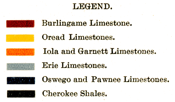
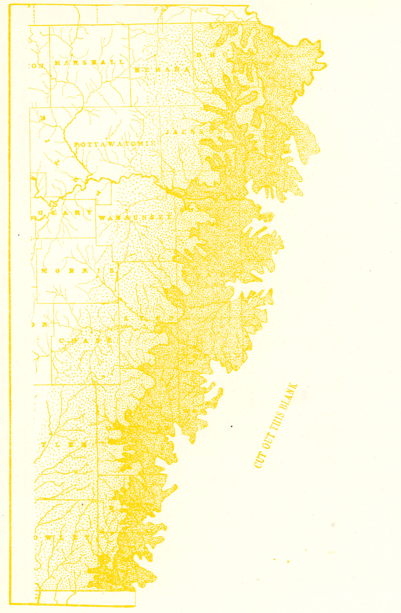
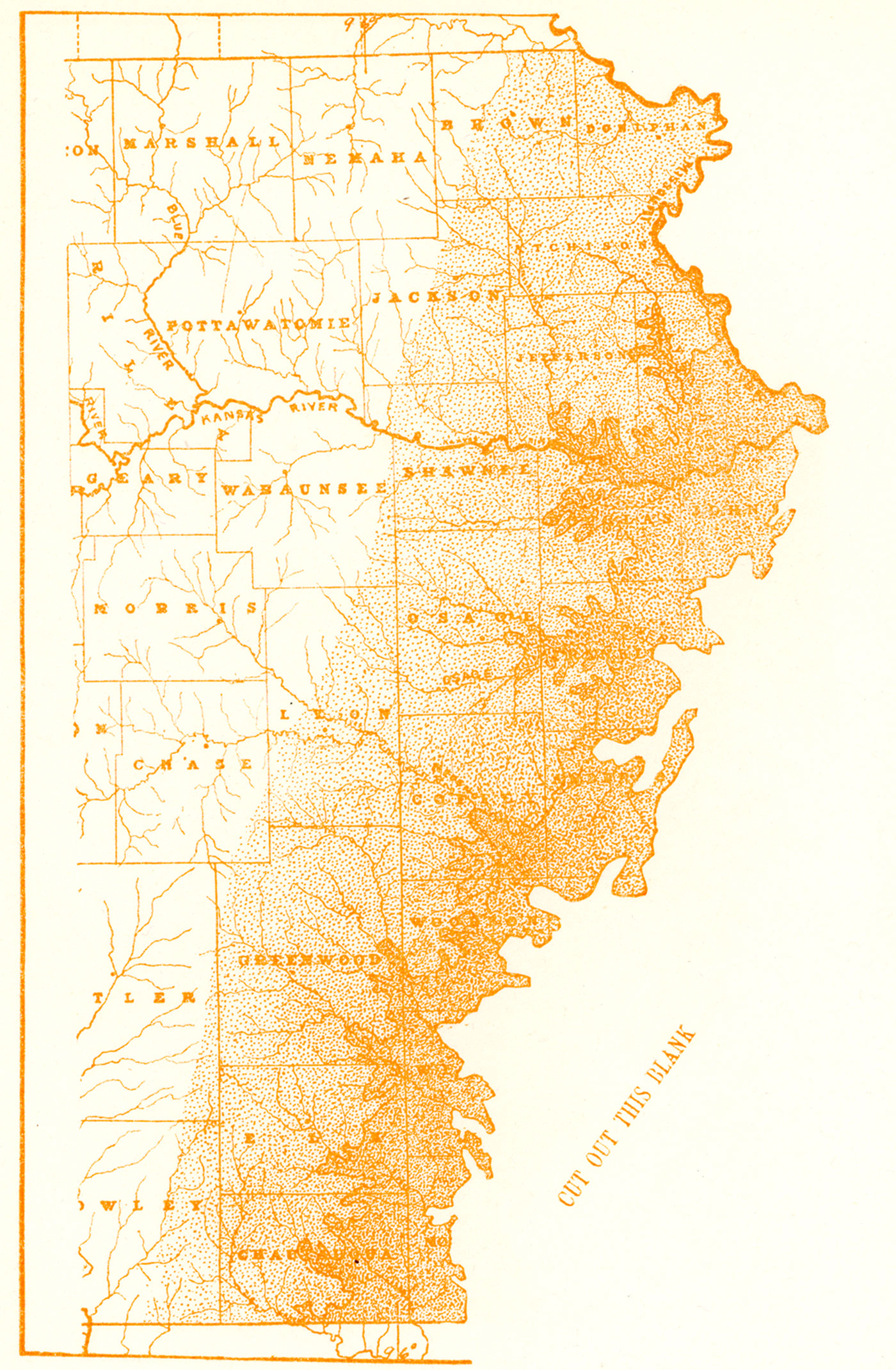
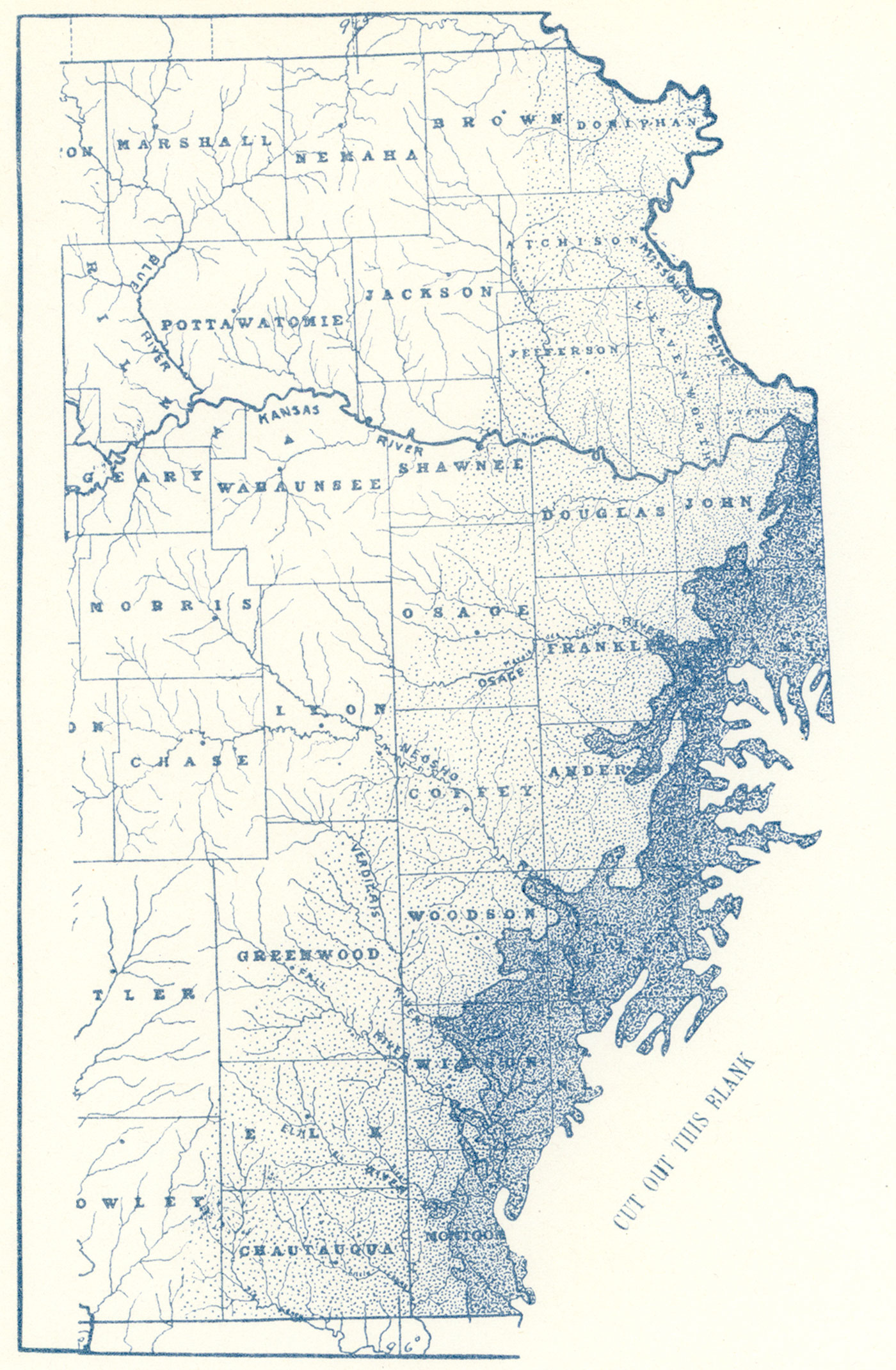
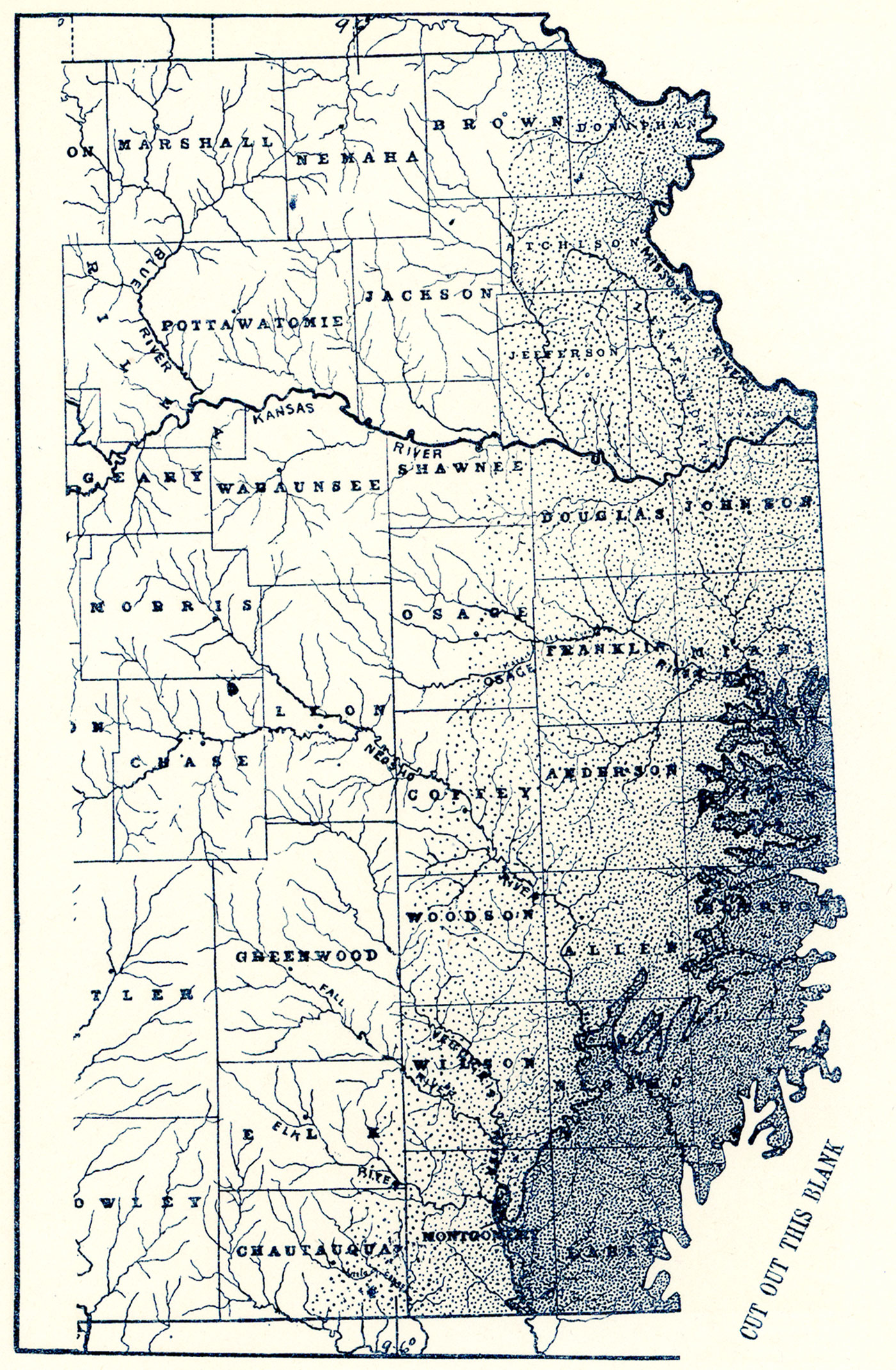
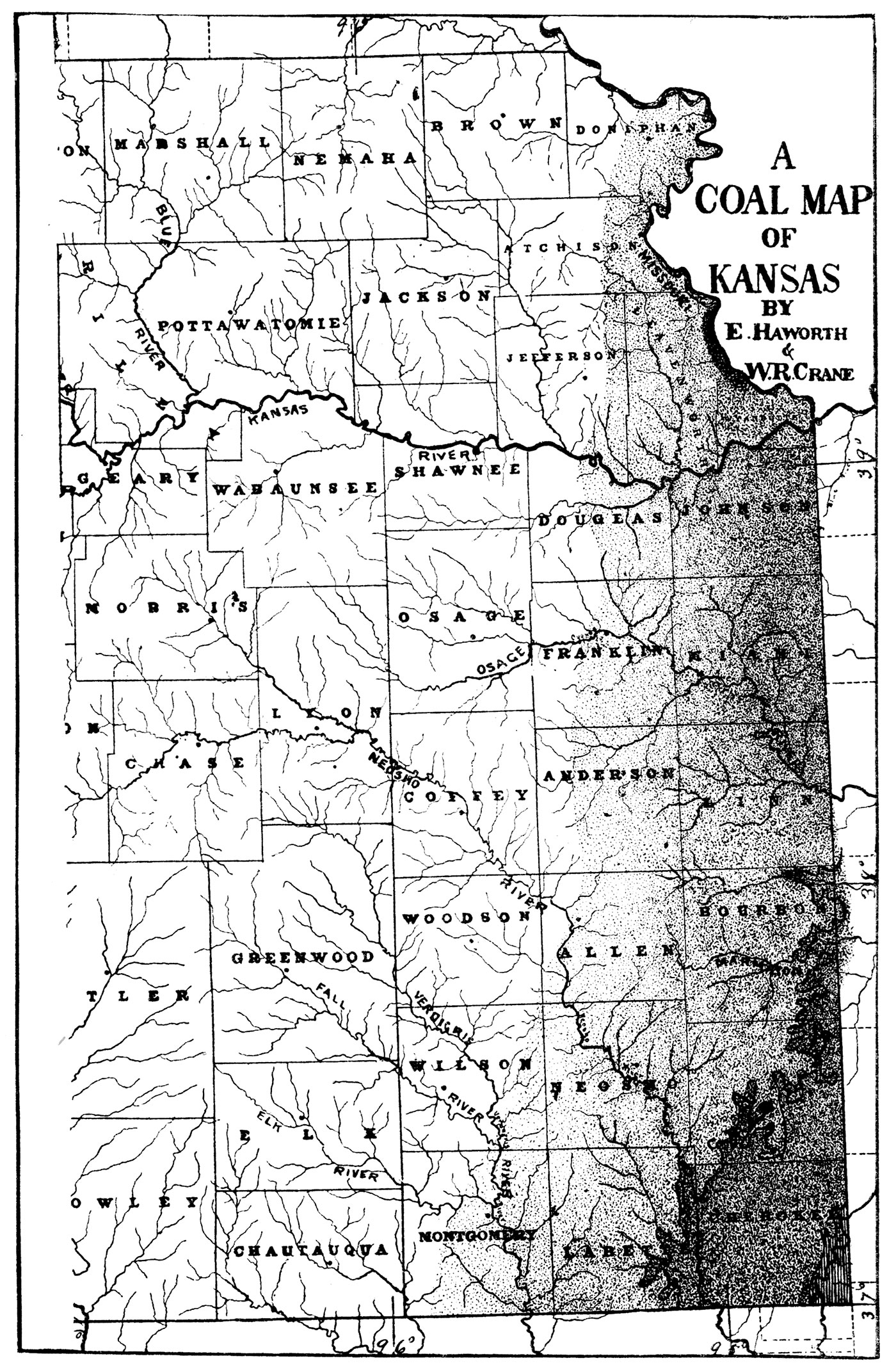
Plate IX—Coal Map of the Dakota Cretaceous. The heavy lines limit the Dakota areas, and the shaded parts show the locations of coal.
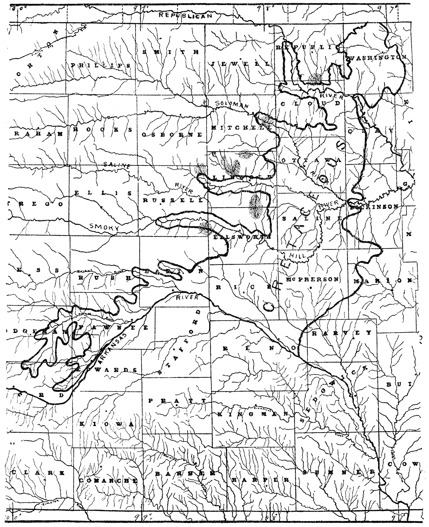
Prev Page--Stratigraphy || Next Page--Geography
Kansas Geological Survey, Geology
Placed on web Sept. 12, 2018; originally published 1898.
Comments to webadmin@kgs.ku.edu
The URL for this page is http://www.kgs.ku.edu/Publications/Bulletins/Vol3/03_meas2.html