![]()
Prev Page—Chapter III || Next Page—Chapter V
Chapter IV—A Geologic Section Along the Missouri Pacific Railway from State Line, Bourbon County, to Yates Center
by John Bennett
| Section at State Line | The Pleasanton Shales |
| Section at Fort Scott | The Erie Limestone |
| The Oswego or Ft. Scott Limestone | The Thayer Shales |
| The Pawnee Limestone | The Iola Limestone |
| The Carlyle Limestone | |
The line of this section, as can be seen on the accompanying state map, trends almost east and west. The road follows the valley of the Marmaton for nearly its entire distance through Bourbon county, then crossing over the divide reaches the valley of the Neosho river at Iola in Allen county, thence passing west again reaches the higher country at Yates Center in Woodson county.
Section at State Line
Beginning in the bed of the Marmaton river, a mile or so east of the state line, in Missouri, we find near low-water mark, coal 15 inches thick; then above the coal 7 feet of shale, and again 4 inches of coal; then ascending through shale 4 feet there is another seam of coal 10 inches thick, then 4 feet more of drab and blue shales, and above this are 8 feet and 9 inches of very dark-bituminous shales, the lower section of which for 2 feet is exceedingly firm and slaty in structure, having imbedded in it large concretions of very hard clays mixed with pyrite which will measure from 1 to 2 feet in diameter. These peculiar forms occur in connection with the Fort Scott coal, and will be noticed more at length when discussing them. Above this firm stratum in the bituminous shale bed are two lenticular beds of argillaceous limestones which contain many specimens of Productus cestriencis. Capping all there is found what is locally known as the "diamond rock." It is a limestone in one stratum in which the vertical seams divide it into rhomboidal or diamond-shaped masses, from which the name is derived.
At the state line we find the same section in part. Our second seam of coal, however, is in the bed of the Marmaton, where, instead of 4 inches, it has thickened to 6 inches, and the 4 feet of clay shales above it and between it and the next coal has thickened to 10 feet. Into this shale there seems to have been interjected here and there bodies of a very hard rough rock. Figure 4 from Fort Scott shows the same formation. The upper seam of coal is here thickened from 10 to 22 inches. At this place the rest of the section was hidden by the soils of the valley until the "diamond rock" was reached, which stratum passes below the waters of the river a mile and a quarter to the west of the state line, and immediately below it in this latter place is found a thin seam of coal. A few of the common fossils of the Coal Measures are found in this rock.
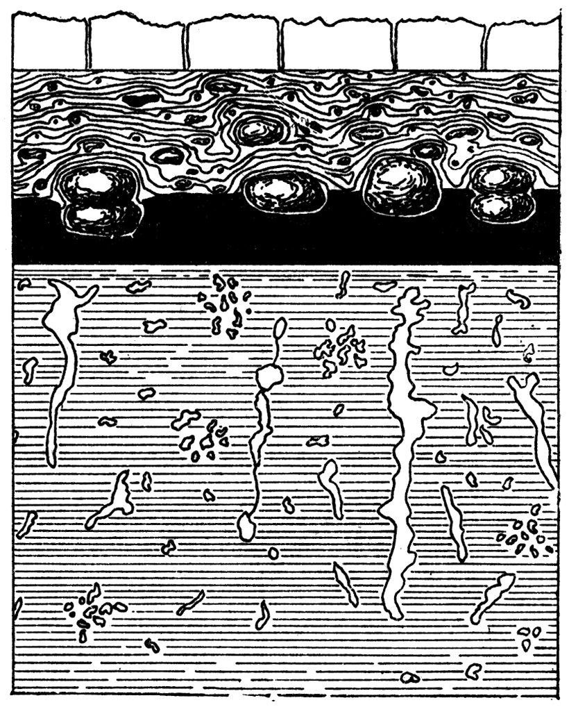
Figure 4—Section at Fort Scott, showing calcareous concretions in the shale adjacent to the Fort Scott coal.
Section at Fort Scott
Between the last mentioned limestone and the celebrated "rusty coal" of Fort Scott lies a heavy body of clay shales varying from 55 to 60 feet in thickness. At places between the state line and Fort Scott there are large exposures of it, and wherever so exposed it is concretionary in structure. In the bed of the river at Fort Scott there is a thin layer of limestone in the shale about 30 feet from the top. Here also, as seen in the railroad cut near the "plaza," is a peculiar structure. For some feet below its contact with the "rusty coal" small masses of limestone containing fossils are found ip it. In places they look as though thrown in at random, then again they seem to pass down through it for several feet in vertical layers. See figure 4, illustrating this peculiar structure.
The "rusty coal," which lies above the shale varies from 13 to 20 inches in thickness, and is mined at the foot of the hills, generally by stripping, from the state line until it passes out of sight by dipping under the higher geologic strata three miles west of Fort Scott. Over almost the entire eastern part of Bourbon county it has been mined continuously since the early settlement of the country, and it was the main source of fuel supply in early days to the Kansas City, Fort Scott & Memphis railroad. It is known in; the markets as the "Fort Scott red coal."
Above this coal is a very dark bituminous shale 3 feet in thickness and in places very firm. Large spheroidal and sometimes compound spheroidal concretions a foot or more in diameter lie at its base, partly in the coal and partly in the slaty shale, (see figure 4). These concretions are generally somewhat flattened and are found at the doors of many residences in Fort Scott, where they are utilized as hitching posts, prepared simply by drilling a hole in one of their flattened surfaces, and fastening a ring therein. Many small ball like concretions, as well as irregularly shaped bodies, are to be found in this shale. They formed originally around some portion of a coal plant, the shell of a mollusk, a crustacean of the shrimp family, or tooth or dermal plate of a fish. They are of all dimensions, from half an inch or less to an inch in diameter, the irregular fornis sometimes reaching six inches in length, but never thicker than the rounded forms. The predominating form which constituted the nuclei was the shell of the little brachiopod Discina nitida. While concretions similar to those which are found in this shale and the shale first above it are also found elsewhere, yet in no other strata of the region are they to be found in such lavish profusion. This shale is of great lateral extent and is noted for its persistent lithologic characteristics, being very dark and abounding in these nodular forms.
The Oswego Limestone
Immediately above this interesting shale bed lies the first important limestone of our section. It consists of a single stratum which is 4 1/2 feet thick, the vertical seams in which cut it into large blocks. These blocks are flat at their base, although they do not lie directly on the shales, for a few inches of argillaceous limestone comes between. This little seam grades from a pure buff clay to a firm rock structure, the firmer portions on some little exposure being easily split up into very thin horizontal sections. The upper portions of the blocks are rounded, giving the surface where some time exposed a rough appearance. Where recently exposed this rough surface is leveled up by hard calciferous clays, the effect of which is to take away the rough appearance of the upper surface. The local name given to the limestone is the "cement rock," from the fact that the Fort Scott hydraulic cement is made from it. At the cement mill, north of the Marmaton, on the Kansas City, Springfield & Memphis railway, it is quarried extensively and burned by the underlying coal. On long exposure the limestone breaks into angular fragments of all dimensions, and it weathers buff, although originally of a light gray color. It is noted for its large crinoid remains—the calcareous columns of these plant-like animals reaching a diameter of 1 1/4 inches. They occur all the way through it, but more frequently in the clays immediately below. Exceedingly large varieties of Meekella striato-costata, Productus punctatus, Athyris subtilita, and other organic remains are to be found in it. A coral mentioned in the system of limestones above this has an existence here (Chetetes milliporaceous), also another coral Syringopora.
Between the "cement" limestone and the system intimately associated with it above, is a stratum of clay and bituminous shales. The latter form the greater part, and at their middle lies a thin coal vein, nowhere over an inch thick along the Marmaton where seen, and frequently in the same region altogether wanting. At the summit of this shale is a yellow day streak varying from 4 inches to a foot which yields a minute form of the characteristic coal fossil Chonetes mesoloba, also many of the dorsal valves of Spirifer planoconvexus. The concretions found so abundant in the bituminous shales below are found in like quantities and peculiar forms, in these similar shales above.
In our upward course we have now reached one of the most remarkable limestones in our whole series. It runs from 10 to 14 feet in thickness. The lower layers are somewhat evenly bedded, with frequent vertical seams, making it easily quarried. This part of it is fairly good building stone, as can be seen in many houses made of it in Fort Scott and the neighboring country. The upper section of it, however, is unevenly bedded, and tells the story of its origin so full of interest to the paleontologist. It takes him far back into the dim and misty past, when innumerable polyp life built up their stony abodes, and left a coral reef for the citizens of Fort Scott to erect their homes upon. Vast quantities of this coral have been crystallized until scarcely a trace has been left of its original condition, but much of it is yet found with its cells as plainly visible as on the day the coral builder put his filmy parting in the honeycombed apartments which he builded so well. In geology his house is known by the name of Chaetetes milliporaceous. [According to Zittle, this is not a coral, but a mollusk of the order Bryozoa.] Everywhere skirting the hills of eastern Bourbon county this rock is to be found, and in Crawford county to the south are numerous and interesting exposures of it with its abundance of Chaetetes milliporaceous. This limestone extends east of Fort Scott into Missouri, and to the west is seen for the last time near the bed of the Marmaton three miles west and two miles south of the city. The Fort Scott, Springfield & Memphis railway rests upon it from Fort Scott to Fulton, a distance of 13 miles. At the latter place it dips below the surface, as is shown on plate II. Its general dip, like all the rocks of the country, is to the northwest, but locally its position is quite horizontal. Sometimes it even rises towards the west and again dips very rapidly, forming anticlinals and corresponding synclinals.
There are good exposures of this interesting rock at the military bridge, one mile east and one mile north of Fort Scott, and at the Missouri Pacific railway cut near the plaza in Fort Scott, where the whole series from 15 feet below the "rusty coal" up to this rock is Exposed, as partly shown in figure 4; again on the west side of the city by the cutting for the Minden branch of the Missouri Pacific railway, and again on the Missouri, Kansas & Texas railway to the southwest of the city three miles.
In the lower section of this limestone the abounding and characteristic fossil is the Spirifera martinia, specimens of which can scarcely ever be taken out of their firm matrix in good condition. The coral so abundant in this system is nevertheless found in great quantities in the next limestone above, at its very summit, but it has not "the lateral extent, as far as observed, which it has in this one. These two limestones combined, the "cement rock" and the coral-bearing rock, have been named the Oswego, or Fort Scott limestone.
Over this limestone is a heavy bed of arenaceous and somewhat micaceous shales, varying from 35 to 60 feet in thickness. At the state line it is 60 1/2 feet thick, at Fort Scott but 39, and at Rock school-house, four miles southwest of Fort Scott, it is 80 feet thick, made so probably by the rapid dip of the limestone immediately below. The dip to the west here is 25 feet in 1,500 feet.
Near the base of this shale bed and at its summit are everywhere to be seen two bituminous layers, the lower one yielding some coal in one place southwest of Fort Scott, where it is mined by stripping. Here it is an intensely black coal and lies in a bed of blue clay shale, not a particle of bituminous shale being in connection with it. This was a feature nowhere else seen in the coal deposits of Bourbon county.
Dividing this whole body of shale into nearly three equal parts there are again two other streaks of bituminous deposits, which, in a few places, yield small quantities of coal. One of these coals, the upper, is capped by a calciferous clay quite cemented in places, and largely made up of broken shells and crinoids. There are many fossils in it unbroken but so covered and cemented in the clays that clean specimens cannot well be secured from it. The prevailing types are Derbyi (hemipronites) crassus, Chonetes mesolobo; (in abundance) Athyris subtilita; Tophophyllum proliferum; Campophyllum torquim, Zeacrinus, and a small gasteropod.
Near the top of this shale at the Missouri state line, but 16 feet from the limstone above, is found 2 or 3 feet of gray limestone in thin layers from half an inch to 3 inches in thickness, which may be called, for want of a better term, shelly lime rock, on account of its laminated condition. This rock is not seen as far west as Fort Scott, but has an equivalent in a calcareous clay of a few inches, and containing fossils such in all respects as I have just above described, These shales carry sandstone in certain localities which are quite firm, but possibly not firm enough for building purposes. Such a condition is found a couple of miles west from the state line, in the road, directly east of Fort Scott.
The Pawnee Limestone
The next rock in superincumbent order to this is a limestone, of which much is exposed in Bourbon county. It is in its total thickness where seen 35 feet, but thickened according to the records of a well at Redfield to 52 feet. In many places where lying at the surface of the country it is a, tough, ferruginous rock, somewhat brecciated in appearance. Great boulders of it cover the country in places and lie partially imbedded in the soils. The lower portions of it cap the hills from the state line to some little distance west of Fort Scott, where it comes down to the common level of the country and begins to show its full thickness before disappearing from view. The Joplin branch of the Gulf railroad is laid upon it from near the junction south of Fort Scott to Farlington in Crawford county. quantities of it have been crushed on Pawnee creek, 10 miles southwest of Fort Scott, by the Missouri, Kansas & Texas railway for ballast.
On the tributaries of the Marmaton, near the station of that name on the Missouri Pacific railway, are some fine exposures of this rock, but on the Marmaton itself two miles to the southwest of the station is to be seen one of the finest of these exposures. The river here cuts through it to its base upon the bituminous shales, leaving a bold overhanging cliff of 35 feet where the following section is exposed. Heavy layers on top and quantities of our coral—Chetetes milliporaceous. From the top of this rock 25 feet down there are several clay partings, and in those partings are pure veins of gypsum one-sixteenth to one-eighth of an inch in thickness. Below this the layers are somewhat evenly bedded.
It will be noticed that the coral common to this and the two members of the Fort Scott system is found in greatest abundance at the close of each limestone-forming period. The coral builders increased in numbers as the culminating points of those ancient reefs were reached. It will also be noticed that seemingly this coral began in the cement rock, reached its climax in the upper Oswego rock, and finally became extinct at the close of the period when the rock under consideration was finished.
In the neighborhood of the cliff already mentioned the Pawnee rock yields in good condition, some few species of fossils, among which are Spirifer martinia; Athyris subtilita; Spiriferina kentuckienses; a ramose coral and columns of crinoidea. The Pawnee limestone disappears below the water of the Marmatoua mile and a half west of this fine exposure, but at once rises again, and just west of Redfield station, less tban a mile farther on, it rises to the height of 20 feet above the river, and almost to the level of the railroad grade. Again it dips rapidly and soon disappears below the valley, so that at Bandera, a mile west of Redfield, it is only reached in the bottom of a well 20 feet deep. The Redfield anticlinal may have been partially formed by the excessive coral building, if the record of the well digger is to be relied upon, as he reports 52 feet of this rock at Redfield. The accompanying plate IV shows the entire strata so far as described.
The lateral extent of this rock is tolerably great. It extends to the southwest to beyond the Neosho river, and to the northeast to beyond the state line. Professor Haworth in chapter II has named it the Pawnee limestone. [Swallow probably refers to this same limestone, and gives it the same name.]
The Pleasanton Shales
Next in order above the Pawnee limestone we find 3 feet of clay shales underlying 6 to 10 inches of coal, which in turn is capped by a very dark, hard, silicious limestone 18 inches thick. Resting upon this lies a heavy deposit of arenaceous shales and sandstones. We could nowhere measure their entire thickness, but at Bandera, one mile west of Redfield, they are at least 100 feet thick. They contain the celebrated Bandera, Gilfillan, and other quarries from whence flagging has been shipped to many of the states of the Union. Forty feet at least above the black silicious rock these flaggings begin at Bandera and continue up for 18 feet; then heavy sandstones and arenaceous shales 30 feet farther to the limestone above. Sixty-four feet of these shales are exposed less than a mile east of Redfield on the bank of the river in the lowest trough of the synclinal of the Pawnee limestone. The bed of the Marmaton here rests on the black rock which covers the coal seam.
The attention of the reader is here called to the fact that less than two miles away from Bandera these shales have almost entirely changed their nature. Here, instead of sandstones they are drab and blue argillaceous yet somewhat arenaceous shales. This would show how the nature of our shales may change in a short lateral distance, and accounts at once for the lack of persistency in our sandstones.
In the southern part of Bourbon county flagging of the same nature is found in these shales, on the divide between the Drywood and Pawnee creeks. In the quarries flagging is taken out in slabs from 2 to 10 inches thick; and are what might be termed an argillaceous sandstone. The stone can be cut in any reasonable size, is quite firm and durable, and much of it as true to a uniform thickness as if put under a planing machine. The ripple and rill markings, with tracks of mollusk and crustaceans, are sometimes beautifully preserved on the surface of the slabs. Only fragmentary remains of the flora however are to be seen, the remains of animal life being nowhere found.
By the erosive forces of the past thin lenticular. silicious, calciferous, and cherty layers in these shales were the sources in many places of the common gravels of the roadside and the farm. Occasionally among these gravels petrified wood occurs. In lateral extent this deposit extends to the southern limit of the county, and to the north trends away in a northeasterly direction, passing into Linn county.
Proceeding on upward in the geologic horizon we reach above this rich commercial deposit of sandstone another system of limestone about eight feet in thickness. At the top it is a loose rock, then a heavy bed, then in thin lamina, and at the base a conglomeritic or perhaps fucoidal rock. Two and a half miles west of Redfield it lies 27 feet above low-water mark in the Marmaton; but a mile and a half farther west It forms the bed and ford in the river, where an excellent exposure is to be seen. In it are to be found well preserved fossils, such as Rhynchonella uta; Spirifer martinia; Reizia mormoni, and Spirifer plano-convexus. Of the lateral extent of the rock we know but little, but from that little are inclined to think it is not very extensive.
The next deposit in the upward order is a heavy shale bed, which was not measured exactly, but judging from the railroad profile, and basing our calculations on the general dip, cannot be far short of 150 feet. In its small outcrops it was found to be a clay but somewhat sandy shale, having here and there in it lenticular if not persistent layers of limestones and sandstones. Not knowing the limestones to be continuous for any great distance we therefore treat the whole as one system of shales. Fourteen feet above the last mentioned limestone there is a layer 2 1/2 feet thick of thinly laminated limestone, which underlies the village of Uniontown. One mile west of Uniontown is a shallow cut on the railroad on which there has been exposed a thin layer of sandstone, and just below it was found 9 inches of hard blue limestone. We will note here that in this shale in the lower thin limestone deposit we found the last specimen observed of the characteristic coal fossil, Chonetes mesoloba, which fact has been used to determine the location of the division line of the Coal Measures. The whole of these shales lying between the Pawnee limestone and the Erie limestone have been named the Pleasanton shales by Professor Haworth in chapter II.
The Erie Limestone
We have now reached a very interesting triple system of limestones which cap the hills in the western part of Bourbon county. They come first into view in the summits of the mounds south of Uniontown, and at the water tank on the railroad, three miles west of Uniontown and 23 from the state line, their base is seen in the railroad cut. Here the road leaves the valley of the Marmaton and passing a little to the west of north rapidly rises over these limestone systems until it reaches the sandy shales above at Bronson.
In detail these limestones are as follows: Beginning at the bottom of the series there is first a dark limestone 16 inches thick in two layers, and above it 3 feet of drab clay shale. Upon this lies 22 feet of unevenly and very heavily-bedded limestone, projecting from the sides of the ravines like unto turreted walls. Immediately above this is 7 feet of Clay shale, then again 3 feet of evenlybedded limestone in two layers, above which lies 4 feet of clay and bituminous shales. Again we come to 16 feet of limestone—the lower portion somewhat evenly bedded, the middle heavily bedded and near to the top brecciated, with few vertical seams—then the top section a somewhat silicious limestone, diagonally laminated in places, like unto some of our sandstones, all standing out in many localities in bold relief along the ravines. Above this is 9 feet of somewhat argillaceous shale, and on these shale we again find a limestone 1 1/2 feet thick, in two layers also evenly bedded. Above this again there is 3 feet of bituminous shale, and superincumbent on this is our third limestone 25 feet in thickness. The lower 20 feet of this last is a somewhat evenly-bedded white limestone with an occasional chert concretion buried in it, but the upper 5 feet is a very cherty rock, around the cherts of which there is much chalky matter. This chert forms a coarse gravel overlying the hills in the immediate neighborhood of its outcrop.
To understand matters here an explanation of the course of the Marmaton is necessary. Leaving Uniontown, the river heads towards the southwest until it enters Allen county, then it deflects rapidly towards the north to its sources northeast of Moran in Allen county. The railway, as we have stated, leaves it passing to the north towards Bronson station, up a small tributary while yet in Bourbon county. The county line is situated on the divide between this tributary and the headwaters of the Marmaton itself. Our triple limestone underlies all this divide, but rapidly dips toward the Marmaton on the west slope, and forms the bed of that stream for some distance. The valley of the river here was given direction by the eroding away of the yielding sandy shales which come next in geological sequence.
Passing from Bronson west we cross the Marmaton after entering Allen county, three miles from Bronson and two from Moran. The limestone does not appear on the railroad although on a down grade some little until the river is reached, but on an abandoned railway grade three or four miles to the south of Bronson a cropping of the two upper systems is to be seen, the lower of which is found near the bed of the river. Following this, towards the north here, it rises rapidly from the water for three-fourths of a mile, then dips and disappears, below the hills. Passing over the Marmaton to its west bank, and up the stream two miles from this last mentioned outcrop, we came to the farm of Mr. McGlaughlin, section 8, township 25 north, range 21 east, where a well had been newly dug close by the river. We found here the upper one of our triple system not far from the surface of the valley. It was known by its fossils and could not easily be mistaken. In fact sandstone quarries were immediately above it. Here also it had its cherty nature and well preserved organic remains.
We stop a moment to call attention to plate IV, on which this series of rocks is represented as it appears, and to the peculiar fact that below each system, and separated by a few feet of shale, is a twin series of even-bedded limestone. But it must be noted also that the even-bedded rocks are generally at the base of every system in the entire section. We also cannot pass over the many species of fine fossils found in the white limestone, or upper one of this triple system. At least 25 species were taken from it, among which were six Productidae, four Spiriferidae, two Terebratulidae, a Nautilus, a Pleurotomaria, an aviculopecten, an Edmondia, a Macrodon, and Bryozoans.
The Thayer Shales
Above the triple limestone the Thayer shales come next, and are at least 100 feet thick, but at no place could satisfactory measurements be taken with.the instruments at hand. On Mr. McGlaughlin's place the lower sections of this shale bed yielded a good quality of sandstone for building, althcugh not in heavy layers. At its summit rests a bituminous shale bed 4 feet thick, but no coal was reported from it.
Iola Limestone
At Moran the highest point on the railroad was reached. The town is on the divide between the tributaries of the Missouri and the Arkansas rivers, and it is said that the waters falling on the east end of the depot seek the Missouri outlet to the Mississippi and those on the west the Arkansas. The town is built immediately on the eastern outcrop of what is known as the Iola "marble." This limestone, for such it is, was easily traced from Moran to the place whence it derives its name, a distance of 13 miles. At Moran 20 feet of it was found in wells. In localities between these stations the surface erosions in creek beds have left but a few feet of it, such as on the farm of Mr. Parke, where but 6 feet of it remains. The westward dip in the 13 miles is about 170 feet, or 13 feet to the mile. As this limestone is described at length by Mr. Adams in chapter I, and by Professor Haworth in succeeding chapters, nothing further need be added here.
The Carlyle Limestone
Above the Iola limestone a monument standing south of Iola on Elm creek, in the shape of a circular mound, will now tell us what comes next in the upward geologic scale. At its base upon the Iola rock rests 15 feet of blue shales, buff limestones, and calcareous shales, quite fossiliferous, containing Nautilus occidentales, Nautilus ferratus (?), Retzia mormoni, etc. Above this are 53 feet of arenaceous and micaceous clay shales, and capping the mound is 6 feet of unevenly-bedded limestone, adapted for rough mason work. Much of it has been removed by the quarrymen. This rock with its numerous fossils was a bonanza to me some four years ago when I first visited it. All the common fossils in the lists already mentioned were found here. This limestone has already been named the Carlyle limestone. Westward from Iola the line of our section carries us to Yates Center. Between these two points limestone is observable at but two places. The first is on the hilltops west of the Neosho river where a limestone system of moderate proportions is found which quite evidently is the Carlyle limestone. Still farther west, about half way between Piqua and Yates Center, either the same or a second limestone is found on the west side of —— creek. It was not yet definitely determined whether this is another exposure of the Carlyle limestone, but quite possibly it is. From here to Yates Center the surface rises quite rapidly, and the roadbed passes onto a high, sandy plateau which is the southwestern extension of the sandstone area in the environs of Burlington. To the west of Yates Center a few miles without any perceptible change in the topographic features the Burlington limestone is reached, which takes us to the end of our section.
Plate IV—A Geologic Section principally along the Missouri Pacific railway from the state line east of Fort Scott to Yates Center.
By John Bennett; to accompany Chapter IV.
Scale: Vertical, 1 inch equals 500 feet; horizontal, 1 inch equals 5 miles.
The limestones are represented by the conventional masonry.
The shales and sandstones are left bare.
The contours are taken from the Missouri Pacific railway track and from the United States Geological Survey Topographic sheets.
Available as an Acrobat PDF, 1.4 MB.
Prev Page—Chapter III || Next Page—Chapter V
Kansas Geological Survey, Geology
Placed on web June 1, 2017; originally published 1896.
Comments to webadmin@kgs.ku.edu
The URL for this page is http://www.kgs.ku.edu/Publications/Bulletins/Vol1/chapt4.html