![]()
Prev Page--Chapter I || Next Page--Chapter III
Chapter II--A Geologic Section from Baxter Springs to the Nebraska State Line
by Erasmus Haworth and John Bennett
[The first part of the chapter to Kansas City is by Professor Haworth, the remainder by Mr. Bennett.]
| The Mississippian Limestone |
| The Cherokee Shales |
| The Oswego Limestones |
| The Pawnee Limestone |
| The Pleasanton Shales |
| The Erie Limestone |
| The Iola Limestone |
| The Lane Shales |
| The Garnett Limestone |
| The Kansas City Section |
| Section at Soldiers' Home. Fig. 4 |
| Section at Atchison. Fig. 5 |
| Section three miles above Doniphan station and two miles south of Brenner station. Fig. 6 |
| Over the Divide |
| Section at Iowa Point and along on the bluff east of it. Fig. 7 |
The Mississippian Limestone
Baxter Springs rests upon the Mississippian, or Sub-Carboniferous ore-bearing series. This series is of undetermined thickness. Jenney [Lead and zinc deposits of the Mississippi valley. Trans. Am. Inst. Mining Eng., 1893, p. 55] has estimated it at about 300 feet. A deep well at Girard penetrated to a depth of 350 feet and seems not to have gone through it; one at Cherryvale penetrated it to a depth of 220 feet without going through it; the artesian well at Fort Scott went nearly 250 feet into it apparently without going through it. An accurate record of the deep well at Paola has not been published and perhaps never can be obtained in reliable form. The well represented in the drawings for this section, plate II, entered the Mississippian only about 20 feet, and the one at Kansas City a less distance. Five wells have been drilled at Pittsburgh, each of which perhaps passed entirely through the Mississippian formation, but no careful record was kept of any of them so that they throw no light upon the subject. The record of the deep well at Leavenworth shows no cherty limestone which to the south characterizes this series, but in its stead gives 300 feet of "hard white sandstone." This "sandstone" possibly is a cherty limestone. The suggestion is made because the cherty limestone is known to exist at Kansas City, and continuously from there to the south line of the state. One can hardly realize how so persistent a characteristic would change so abruptly. Further, at the great depth at which the "sandstone" was reached it would be a comparatively easy matter for the driller to mistake the chert grains produced by the "churn drill" for grains of sand. This thought is strengthened by the fact that the Mississippian series is preeminently a limestone series wherever known throughout the whole Mississippi valley. If the well record is in error as indicated we should consider the limestone series 300 feet thick at Leavenworth.
The upper surface of the Mississippian was greatly eroded during pre Coal, Measure time, as has already been shown in chapter I in the description of the section along the south line of the state. The surface dips gradually to the north, as is plainly shown in plate II, which was drawn to an exact scale, the information being gathered mainly from the records of the deep wells along the lines. The outline map, plate XXXI, shows that this section trends only slightly diagonally to the boundary line between the Mississippian and the Coal Measures, and therefore the dip would not be nearly so great as in directions at right angles with the boundary. As it is we have a dip of 333 feet from Baxter Springs to Girard, a distance of 35 miles, or 9.5 feet to the mile; a dip of 433 feet to Fort Scott, 62 miles, which gives 7 feet to the mile; a dip of 635 feet to Pleasanton, 87 miles, or 7.3 feet to the mile; a dip of 975 feet to Paola, or 9 feet to the mile; and one of but 800 feet to Kansas City, or 5 feet to the mile. It will thus be seen that the upper surface of the Mississippian has great irregularities which cannot be attributed to surface erosion, but rather to great undulations which are essential properties of the whole system. The great synclinal at Paola corresponds exactly with the position of the higher limestones, although the Cherokee shales are so thickened here that it would seem there can be no relation between the Mississippian limestones and those above the shales. From Kansas City to Leavenworth the direction is changed to one almost at right angles with the boundary between the Coal Measures and the Mississippian, so that we would expect to have almost the maximum dip. In a distance of 22 miles there is a dip of 390 feet, or 18.2 feet to the mile, which is nearly equal to the westerly dip of the surface of the same series from Galena to Cherryvale, which has been shown to be about 21 feet to the mile.
The Cherokee Shales
Immediately above the Mississippian are the Cherokee shales and sandstones, the lowermost portion of the Coal Measures. Less than a mile to the west of Baxter Springs is a series of sandstone covered, hills from 50 to 75 feet high, the main body of which is principally shale, but which here and there has considerable sandstone interbedded with it. Such hills are irregular in their position, indicating a lack of regularity in the protecting sandstone covering. One circular hill about six miles to the west is particularly prominent, as it is entirely surrounded by a broad valley of erosion with the hill nearly 150 feet high standing alone in the center. The sandstone on the summit of this bill mayor may not be the equivalent of that nearer Baxter Springs. Passing northward towards Columbus the sandstone and shale alternate with such frequency that one is entirely unable to trace the former any considerable distance. That near Baxter Springs may with question be correlated with the sandstone on top of the hills east of Columbus, and on which Columbus rests. The section from Baxter Springs to Columbus, if represented in great detail, would well illustrate the utter futility of using sandstones within the Cherokee shales as important stratigraphic factors; for, not even one of them below the Columbus sandstones, numerous as they are, can be traced very far until it gradually changes into arenaceous shales, and finally into shales of the ordinary type.
At the altitude of Columbus, or about 200 feet above the Mississippian, we find a heavy sandstone deposit which is, tolerably persistent towards the east for seven or eight miles, forming the uppermost portion of the highlands and hills to the east, almost to Crestline, a station eight miles east of Columbus on the St. Louis & San Francisco railway. This system of hills is well represented In the section along the south line of the state, plate I, as are also the various coals occurring in the Cherokee shales below the Columbus sandstones.
Passing northward from Columbus nothing of special interest is found until the Weir City-Pittsburgh coal is reached, about four miles north of Columbus. The roofing for the coal is shale, so that no topographic features mark the outcropping, and the weathering has produced so heavy a soil covering that the outcropping can only occasionally be seen. This coal is the heaviest and most important of any in the state. Its southeastern limit is a sinuous line trending northeast to southwest approximately parallel to the boundary between the Coal Measures and Mississippian. In the early days of mining the stripping process was principally employed. This located a number of mining villages along the line of outcropping, which, in turn, attracted the different railroads. Both these causes, in connection with the desirability of shallow shafts when shafting became necessary in the mining operation, have contributed to building the principal mining towns along this northeast and southwest line. The coal extends to the northwest much farther than mining operations have progressed, but the limit of workable coal is soon reached, as is shown by the well at Girard and many other prospecting drill-holes which have been made from time to time. The belt of workable coal seems to be a strip from five to ten miles wide reaching from beyond Mulberry on the northeast almost to Hallowell on the southwest. The exact definition of the area can only be determined by the most extensive prospecting with the drill, or by shafting, a process so expensive that this Survey could not begin it. Such prospecting has been done to a considerable extent by the different mining companies and landowners, sufficient to justify the above statement of limitations, but not sufficient for giving details along the borders.
The coal averages about 40 inches thick where mined, but over considerable areas within the mining district it is only from 24 to 36 inches in thickness, while in other places it considerably exceeds 40 inches. On the whole it is a remarkably uniform coal deposit, both in thickness and quality. Few coal beds are known in America with equal areal extent which are as uniform in quality and quantity as this.
The coal beds dip to the west and northwest, quite irregularly over small areas, but approximating the dip of the surface of the Mississippian for long distances. In some places the dip for a short distance is as great as three or four degrees, or 275 to 365 feet to the mile. But such steep inclinations are usually followed by lesser ones, or by actual reversals, so, that the general average is brought down to about 20 to 21 feet to the mile.
The mining operations have revealed an important condition which perhaps is always concealed from view at the surface, namely, the slight fissuring and faulting of the strata. The so-called "horsebacks" of the miner are variable in character. One type consists of a fissure formed in the coal and shales, both above and below, long after the coal was formed, which has since been filled with clay from the walls of the fissure in the overlying shales, or by the "creeping" of the clay beneath. Such fissures have been formed from one to five or more feet wide, either with or without vertical displacement. When displacements occur they usually are from 6 to 12 inches, but occasionally reach two or three feet. In some cases small fragments of coal have been found imbedded within the clay filling, as though it had fallen in during the filling process. Also the line of fracture is rarely straight through the coal, but the irregularities on one side generally correspond quite well with those on the other. Many of the fissures are only partially filled with the clay. One was noticed at Weir City which extended unfilled upwards into the roof for 10 or 15 feet, as could plainly be seen while standing in the driveway of the mine. There can, therefore, be no doubt but that the fissuring and faulting was done long after the solidification of the coal, possibly during the period of the production of similar fissures and faults in the lead and zinc mining districts to the southeast. [Jenney: Lead and zinc deposits of the Mississippi valley, Trans. Am. Inst, Mining Eng., 1893, p. 55.]
The Cherokee shales have a few thin, irregular limestone beds within them. Only one of them has sufficient thickness or lateral extent, as developed at the surface, to be of any importance stratigraphically. This one lies 75 feet below the upper limits of the shales, and is from two to five feet thick. According to the reports obtained from Mr. W. E. Turkington, of Cherokee, Kas., a gentleman of wide experience in prospecting with the diamond drill, it is varied in its occurrence. He reports that in many wells, especially those to the northwest, it is not found. At Oswego it is about three feet thick. It is visible in a number of different places to the northeast of Oswego, is plainly to be seen in a ravine half a mile to the west of Cherokee, and should be about 20 feet under the surface in the town. But Mr. Turkington reports that it is not, nor is it met with to the south, as he has determined by many drilled wells. In the drawing, plate II, it is represented as first appearing to the south of Cherokee. This was done in order to place it at the proper height vertically. In the vicinity of Fort Scott two or more small limestone formations occur near the same vertical position, but there is great uncertainty about correlating it with either of them; for it may well be questioned whether so thin a limestone system would have so great a lateral extent. Yet it should be noticed that in the other wells to the north, even as far as Kansas City, more or less limestone is found at about the same geological horizon, indicating that at this particular period more or less limestone was formed almost all over the Coal Measure area.
The total thickness of the Cherokee shales along the east line of the state may be given at 450 feet, although they are not entirely uniform. At Girard the drill record shows them to be 446 feet; at Fort Scott they are a little less than 425 feet; at Pleasanton they are full 440 feet; at Paola they have thickened to nearly 750 feet, if we may credit the record of the city well, the most reliable of any record available; at Olathe their thickness is unknown. The well represented in plate II evidently did not reach the Cherokee shales at all. At Kansas City they have a thickness of 420 feet, and at Leavenworth they are full 540 feet.
The Oswego Limestones
First above the Cherokee shales lie two limestone systems so close together that they may well count as one. They occur prominently at Oswego, and have been called the Oswego limestone. From Oswego their outcropping extends northeast, passing about two miles north of Cherokee, half way between Girard and Pittsburgh, and capping the high hills between Pittsburgh and Englevale, from which they pass to beyond the state line. To the northwest of the line of outcropping they cover nearly all the surface for a distance of 8 or 10 miles, the highest hills only being capped with a limestone occupying a higher position, while the lowest valleys may lie partially or wholly within the Cherokee shales. In this way they extend northward to Fulton, beyond which they pass below the surface to be seen no more along the line of this section. The character of the Oswego limestone as seen in the environs of Oswego has already been given by Adams in chapter I of this Report. They maintain this character with wonderful persistency in all directions. At Girard the lower one is 18 feet thick and the upper one 14 feet thick, and are separated by only four feet of black bituminous shale. At Fort Scott they are exposed over several square miles of surface. Here the lower one is a little over five feet thick and constitutes the "cement" rock from which the Fort Scott hydraulic cement is so extensively manufactured. Above the "cement" rock the shale is seven feet thick, and includes a thin seam of coal of three or four inches in thickness. Above this comes the upper Oswego system which is 10 feet thick. Immediately below the cement rock the shale is likewise very black and bituminous for a distance of 11 feet, immediately below which is the Fort Scott "red" coal with an average of about 13 or 14 inches in thickness at this place. The Oswego limestones are therefore associated with the two beds of jet-black shale, the one below and the other between the two. These shales have such marked characteristics that they are of great assistance in recognizing the limestone series. They also have great lateral extent, reaching all the way from Girard to Fulton without any perceptible change in their characteristics. Mr. Bennett has described them in considerable detail along with the Fort Scott coal and the two limestone systems as they occur at Fort Scott in his description of a section from Fort Scott to Yates Center given in chapter IV of this Report.
Regarding the terms by which these limestones should be designated it may be said that although the name "Oswego" limestones has been used it would be equally convenient to call them the Fort Scott limestone. Should one choose to use the latter term rather than the former, one should be careful not to include the upper limestone, a heavy system which is well developed around Fort Scott, capping the hills on all sides.
The Oswego limestones, although perfectly conformable with each other are rarely found in an exact horizontal position. A glance at plate II will show this better than it can be described by words. There is a great anticlinal ridge between Pittsburgh and Fort Scott with its axis trending about south 70 degrees east. In extreme cases the limestone dips either north or south two degrees or more. South of Englevale about a mile they dip north fully 150 feet to the mile for a distance of half a mile, beyond which on either side the inclination is greatly reduced. Another similar instance was noticed on the south side of the ridge about four miles east of Girard. Here along the headwaters of one branch of Cow creek an exposure was found where the limestone dipped southerly at the rate of over 100 feet to the mile. It is probable the southeast dip of the limestone is the principal cause for the absence of a marked escarpment at the border or outcropping of the limestone. At Fort Scott the rocks are dipping north, but three miles north, just beyond the cement factory, they begin rising to the north at a sharp angle. This is plainly noticed along the railroad, for the roadbed rests directly upon the upper limestone for nearly a mile, throughout the whole of which distance there is a relatively heavy grade.
First above the Oswego limestone is a bed of shales, arenaceous in places, which varies in thickness along this line from 25 to 40 feet. At Fort Scott it measures nearly 40 feet, while five miles to the north it is not more than 25 feet thick In a few places it assumes a jet-black color and contains many small concretions with small fossil shells serving as nuclei, just as those between the Oswego limestones. This is particularly noticeable at Prescott. The well and pool by the old mill have passed through the limestone, which was quite thick here, and have revealed the black shale filled with concretions. One might easily be misled here, for it would be natural to mistake this limestone with the associated shales for the Oswego limestone. Coal is also found in these shales in some localities, but only in small quantities, and therefore not of sufficient extent to be of any commercial importance.
The Pawnee Limestone
Above the shales just mentioned is a tolerably heavy limes one system which is first observed along this section a little south of Farlington. Its exact limits could not be located along the railroad. but only a few miles north of Girard to the east and west of the railroad prominent escarpments locate its limits exactly. At Farlington it is very prominent, and is easily traced all the way to beyond Fort Scott. In character it is massive rather than laminated. Along the hilltops it weathers into large blocks rather than small fragments. Its thickness is difficult to estimate on account of its being worn to a thin edge, but it reaches 15 feet in some places. According to Mr. Bennett, in chapter IV, a few miles to the west of Fort Scott it thickens to fully 30 feet.
This limestone has been named the Pawnee limestone by Swallow [Swallow: Prel. Rep. Kansas Geol. Survey, p. 24; Lawrence, 1866] on account of its great development around Pawnee, a station on the Missouri Pacific railroad to the south of Fort Scott. As the name was well chosen, and corresponds with the method adopted by this Survey of giving local geographic names to the different geologic horizons, it will be adopted here. In the vicinity of Fort Scott the Pawnee limestone caps all the hills. Passing northward to Prescott it can be seen on hills all the way on either side of the Memphis railroad. At places the track rounds a hill point with the limestone only a few rods away, while beyond the valley may widen to miles each side of the track About five miles to the north of Fort Scott the limestone comes down to within 25 feet of the Oswego limestone, but beyond it rises slightly to a height of 40 feet or more. Just south of Hammond, a small, flat-topped, circular mound, capped with the Pawnee limestone, is, a prominent feature in the landscape, while to the southeast and to the northwest rows of hills of some height are capped with the same rock At Prescott it lies at the surface, while farther north it passes underground and is seen no more, excepting in the shafts below the coal at Pleasanton and Boicourt, and in the records of the drilled wells at Pleasanton, Paola, and other points to the north.
The Pleasanton Shales
Above the Pawnee limestone lies a heavy bed of shale which is of great stratigraphic importance. It contains within it one or more small limestone systems of little importance. Such an one is the limestone northeast of Pleasanton along the branch, the eight-foot one mentioned by Bennett on the Fort Scott-Yates Center section, and the one near the surface just above the Mound City coal, which seems to be the same as the one northeast of Pleasanton. On account of the heavy development of these shales at and around Pleasanton it is proposed to call them the Pleasanton shales. They have been an important factor in producing the topography so characteristic of the zone reaching from La Cygne away to the southwest to beyond the Neosho river, and in fact by way of Cherryvale and Mound Valley to the south line of the state. Could one stand on a high prominence near Fort Scott and use a proper telescope he could observe a chain of hills and bluffs throughout this whole distance. Beyond the Neosho river the row becomes divided into two or more branches, but nearer Pleasanton they are united into one. The Pleasanton shales constitute the great bulk of these hills and the limestones above cap them and protect them from erosion. The thickness of the Pleasanton shales differs greatly. At Boicourt they are more than 225 feet thick, with an equal thickness to the southwest; but to the north they rapidly become thinner as far as Paola, beyond which they again thicken to nearly 200 feet at Kansas City.
In places the Pleasanton shales carry large quantities of sandstone, sometimes in broad, even, thin layers, producing the best of flagging stone, sometimes in more massive form. Excellent examples of the former are found near Bandera and Gilfillen west of Fort Scott, the quarries of which produce what is known in the market as the Fort Scott flags. Near Farlington is another place where flagging stone of excellent quality are extensively quarried from beds contained within the Pleasanton shales. Other examples also might be mentioned, particularly the flagging stone west of the Neosho river quarried so extensively by Mr. Robinett who has introduced them to the city of Parsons and supplies such great quantities for making walks. The massive variety of sandstone is well illustrated at Boicourt by the heavy beds which lie at the very summit of the shales immediately under the next succeeding limestone. Here the layers are four or more feet thick and were once quarried for dimension stone.
The Pleasanton shales are also noted as coal-producers. The Pleasanton coal, the Boicourt coal, the La Cygne coal, and the Mound City coal all come from them. The Pleasanton, Boicourt, and La Cygne coals lie almost at the base of the shale beds, but the Mound City coal is nearly 100 feet higher. To the south of Pleasanton, almost all the way to Fort Scott, coal is mined irregularly every few miles on each side of the railroad. Some of these mines seem to be located below the Pawnee limestone, possibly below the Oswego, in which case they would correspond to the Fort Scott coal. But others of them are higher and may correspond to the Pleasanton coal. As but few of such banks were visited, positive statements regarding them cannot be made.
It has been decided to let the upper surface of the Pleasanton shales be the upper limitation of the lower Coal Measures. The paleontologic evidence favors this, while other considerations are given in chapter IX for locating the division of the Coal Measures at this particular place.
The Erie Limestone
Above the Pleasanton shales a series of limestone systems is met with which consists of five or six systems at La Cygne, a smaller number south at Boicourt, and still smaller at Pleasanton. At the latter place there is but one limestone capping the hill, or possibly two, with almost no shale between. This limestone also forms the top of a long row of hills reaching westward toward Mound City. At Boicourt, the high hill west of the railroad furnishing the following section, beginning at the top of the hill and passing downwards:
| No. 1--20 feet limestone. |
| No. 2--6 feet shale. |
| No. 3--6 feet limestone. |
| No. 4--6 feet shale. |
| No. 5--4 feet limestone. |
| No. 6--4 feet shale. |
| No. 7--5 feet limestone. |
| No. 8--11 feet shale. |
| No. 9--10 feet sandstone. |
| No. 10-94 feet shale to road grade. |
The same shale continues to the bed of the river. From the best information we could gather it seems that the shale continues downward a hundred feet or more, making the total thickness of the Pleasanton shales from 200 to 225 feet. It will thus be seen that four limestone systems are here found. The lower one possesses all the characteristics, both lithologic and paleontologic, of the one at Pleasanton, and unquestionably should be correlated with it. Of those above the first two are thin, with the lower one probably belonging to the bottom one. The fourth one is the most nearly distinct.
The high bluffs and hills north of La Cygne furnish another good section. The limestones are here dipping rapidly to the north. The Memphis railroad cuts through them to obtain a crossing over the Osage river, so that portions of the rocks are laid bare in the cut. The following section is here exposed, the hill on the east side being higher than the one on the west. Beginning at the top of the hill and passing downward we have:
| No. 1--25 feet limestone. |
| No. 2--20 feet shale. |
| No. 3--20 feet limestone. |
| No. 4--13 feet shale. |
| No. 5--4 feet limestone. |
| No. 6--8 feet shale. |
| No. 7--3 feet limestone. |
| No. 8--8 feet shale. |
| No. 9--2 feet limestone. |
| No. 10--7 feet shale. |
| No. 11--7 feet limestone. |
| No. 12--11 feet of shale to railroad level with river bed 46 feet below. |
Here also the lowest limestone system corresponds with the bot, tom one at Boicourt and Pleasanton, so much so that one need have no hesitation in correlating it with them, although it must dip rapidly from Boicourt to reach its position here.
By comparing these sections with Mr. Bennett's section from Fort Scott to Yates Center and considering topographic features to the southwest, as above outlined, it would seem we are here dealing with the limestones which form the heavy outcropping near Uniontown which has been called the Erie limestone farther to the west. They can be traced northward all the way to Kansas City, at which place the lowermost one corresponds to No. 78 of Broadhead [Missouri Geol. Rep., 1872, p. 83] which he calls the Bethany Falls limestone.
Iola Limestone
Here at La Cygne we have another limestone lying above the Erie limestone and which seems to be the Iola limestone. At Iola 100 feet of shale lie between it and the Erie, but here there are scarcely more than 25 feet. Further, instead of having only three systems below there are five close together, as though they were related, but some of them are so thin they may not extend far away. The uppermost rock at La Cygne possesses all the characteristics of the Iola limestone, compact, solid, crystalized almost into a marble, and unusually free from fossils. In order to throw light upon this correlation a journey was made west from La Cygne until the Garnett limestone was reached. By counting southward from this point to Iola and eastward to La Cygne the same conclusion is reached, so the matter may be looked upon as settled that the uppermost limestone system in the vicinity of Mound City, Boicourt and, La Cygne is the Iola system. Immediately on the high hill at Boicourt it is not found, but it is reached, only a short distance to the west. At the bluff north from the river near La Cygne the same grouping of limestone systems is noticed. Here, however, they dip to the south, or rise to the north towards Fontana. The Osage river is, therefore, following a synclinal valley at this place. The railroad from the bridge near La Cygne gradually climbs the hill occupying four or five miles in making the ascent to Fontana. In many places along the line the grading has laid the hillside sufficiently bare to furnish good sections. It is noted that the massive limestone is plainly visible almost all the way with the lower systems in their proper places relatively. To the south and west of Fontana the Iola limestone appears everywhere at or near the surface, constituting the great mass of limestone so abundant in that vicinity. It gradually dips towards the northwest to Osawatomie and to the north to Paola. Fontana is therefore on the summit of an anticlinal ridge the axis of which trends about north 70 degrees west, gradually dipping below the surface. The Iola limestone lies near the surface all the way to Paola, at which place it covers the lesser hills of the main upland. It is found in a number of places within the city limits, and is the first limestone system below the one covering the highest hilltops in and around Paola. It is here greatly reduced in thickness, not being more than 15 feet thick in most localities. Just how much its original thickness has been reduced by surface erosion cannot well be determined. To the north, towards Olathe, it gradually becomes more prominent. On many of the lesser hills to the east of the Memphis railroad it is very prominent. In some places four or five miles east of Paola it caps prominent, flat-topped mounds and rows of hills. At Hillsdale it is the cap-rock on the hilltop just south of Bull creek, plainly visible near the wagon bridge. It rises all the way from Paola to Olathe, at which place it is so thickened that along the head waters of Cedar creek, from two to four miles west of Olathe, it is full 50 feet thick. From Olathe it passes on to the north and constitutes the heaviest limestone in the bluffs of Kansas City numbered 98 by Broadhead. [Broadhead, loc. cit., p. 107.]
The Lane Shales
Above the Iola limestone along the line of this section a shale bed appears which, in the vicinity of Osawatomie and Paola, is from 75 to 100 feet thick. Along the south bluffs of the Pottawatomie river it is generally about 75 feet thick; between Osawatomie and Paola at one place it measured 95 feet; while in the hills northeast of Paola it is from 75 feet downwards as more northern points are reached. It forms the main mass of hills each side of the Memphis railroad from Paloa to Olathe, but it gradually grows thinner, as the Iola limestone rises, until in the vicinity of Olathe it is less than 25 feet thick. West of Olathe along the bluffs of Cedar creek it seems to thin out so that the Iola limestone and the one above almost come together, and are in places not more than 10 or 15 feet apart. But to the southwest beyond Osawatomie, they gradually thicken to much over a hundred feet. They separate the Iola limestone from the limestone system containing the famous quarries at Lane, and the Garnett limestone in and around Garnett, and therefore should be correlated with the great shale bed on which Colony rests, and which furnishes so much sandstone in the vicinity of Neosho Falls, Burlington and Yates Center. The name Lane shales is proposed for this shale bed, on account of their being so well developed at the little town of Lane, a village made somewhat famous in Kansas on account of the extensive quarries near by, and also to emphasize the fact that the Lane "marble" and the Iola "marble" belong to two different limestone systems.
The Garnett Limestone
Beginning at the summit of the highest hills southeast of Paola, an important limestone system is first met along this section which is very prominent to the southwest, and which has already been named the Burlington, or Garnett limestone. [Haworth and Kirk: Kansas Univ. Quar., vol. 2, p. 110.] In most places it is recognizable as two distinct systems about 10 or 15 feet apart, but from Paola to Olathe it usually is seen as but one. It caps all of the highest hills between these two places, and for miles around. As has just been shown, it is slightly nonconformable with the Iola limestone, due to the thinning out of the Lane shales to the northeast. Immediately under the town of Olathe it is only 15 feet thick, but a few miles west it thickens to nearly 50 feet. This is the same system which a mile southwest of Greeley thickens so suddenly locally from a few feet to almost 50. From Olathe it dips slightly in almost every direction excepting the east. It reaches Ottawa and beyond to the southwest, where it is in two well-marked systems, and Eudora to the northwest. It is quite possible, in fact probable, that around Paola and Olathe it is in two systems with so thin a parting of shale that it has been misinterpreted. Its most noted feature, and the one which will give it the widest reputation, is the fact of its containing the famous "marble" quarries at Lane. From Olathe it passes northward to Kansas City, as is shown in plate II.
The general highlands forming the environs of Paola and the broad plateau of Olathe pass northward unchanged to the bluffs of the Kansas river between Kansas City and Eudora. The different rock systems, then, along the river bluffs are practically the same as those described from Pleasanton northward. The borings at Paola: and Olathe confirm this view, as is shown in plate II, which, should be referred to constantly while reading this chapter.
The Kansas City Section
[The remainder of this chapter is by Mr. Bennett.]
A comparison between the stratification at Kansas City, as now seen in the bluffs where good exposures are made by natural or artificial means, and the description given by Broadhead [Broadhead: Missouri Geol. Rep., part 2, p. 107, 1872] shows that his section is correct in the main excepting near the summit of the bluffs, where good exposures did not exist at the time his report was prepared. The complete section is as follows, beginning at the top, which is almost identical with the Argentine section, figure 2:
| Section at Kansas City |
|---|
| 1st--6 to 10 feet arenaceous limestone. |
| 2d--6 feet sandy shale, which reaches to Broadhead's section. |
| 3d--30 feet gray, bluish gray and flesh-colored limestone, the Iola limestone. |
| 4th--25 feet blue and olive-colored shales. |
| 5th--5 feet heavy-bedded limestone. |
| 6th--Thin seam of clay, 4 inches. |
| 7th--15 inches blue limestone. |
| 8th--2 feet bituminous and blue clay shales. |
| 9th--18 inches in one bed of limestone. |
| 10th--16 inches blue clay shales. |
| 11th--16 inches blue limestone largely composed of comminuted shells. |
| 12th--11 feet: 5 feet 8 inches blue clay shales and 5 feet 4 inches buff and drab nodular shales. |
| 13th--9 feet fine-grained, greenish gray, even-bedded limestone. |
| 14th--7 feet clay shales. |
| 15th--3 feet irregularly-bedded limestone. |
| 16th--18 feet oolitic and gray limestone. |
| 17th--13 feet shale. |
| 18th--1 foot agrillaceous limestone made of comminuted shells. |
| 19th--10 inches drab day shales. |
| 20th--5 inches argillaceous limestone. |
| 21st--2 feet drab clay shales; 6 inches buff shales, and 6 inches blue shales. |
| 22d--1 foot argillaceous limestone. |
| 23d--1 foot buff and 3 feet of blue shales. |
| 24th--12 feet deep-blue limestone and black chert in the upper 4 feet. From this down it is an argillaceous limestone and blue in lower strata. |
| 25th--4 feet blue clay shale. |
| 26th--7 1/2 feet heavy limestone, in two layers. |
| 27th--10 inches blue shale. |
| 28th--5 feet even-bedded limestone. |
| 29th--2 inches of clay. |
| 30th--3 inches limestone. |
| 31st--3 inches buff shale. |
| 32d--1 foot buff clay rock. |
| 33d--10 inches yellow ochre shale. |
| 34th--2 feet drab shale. |
| 35th--H feet bituminous shale. |
| 36th--3 feet clay shale. |
| 37th--2 feet nodular buff shale. |
| 38th--18 to 20 feet heavy-bedded limestone (Bethany Falls of Broadhead). |
| 39th--5 feet drab, blue and bituminous shales. |
| 40th--1 1/2 feet even-bedded limestone. |
| Making a total of about 225 feet. |
Figure 2--Argentine section.
In the above section it can be seen that there are at least eight limestone systems some of which have been correlated with those described in previous chapters. In the descending order they are as follows:
| 1st--The arenaceous limestone--10 feet. |
| 2d--The Iola limestone, top rock of Broadhead and heaviest bed--30 feet. |
| 3d--Large fossil and heavy-bedded limestone--5 feet. |
| 4th--Fine-grained building-rock--9 feet. |
| 5th--Oolitic limestone--21 feet. |
| 6th--Black, cherty limestone--12 feet |
| 7th--Heavy-bedded and clay parted limestone--12 1/2 feet. |
| 8th--Bethany Falls of Broadhead--20 feet. |
These are persistent systems and we will have occasion to speak of them again in the Kansas river section, Chapter VI of this Report. It will be seen that they represent fully 119 feet of the section, and that the separating shales, etc., sum up 106 feet of which 94.6 feet are clay and bituminous shales, and 12 feet thin limestone layers, giving a preponderance to the limestone, all told, of 35 feet in the entire 226 feet of the section. Before going further a brief description of the fossils found in these systems might be of interest.
The arenaceous or uppermost system has a few of the common Coal Measures species--Athyris subtilita being plentiful.
The Iola limestone, or top rock, yields some well preserved fossils, such as Spirifer cumeratus; Spiriferina kentuckieneis; Productus longispinus; Productus costatus; Productus punctatus; Productus nebrascensis; Terebratula bovidens; Athyris subtilita; Myalina swallovi; Bryozoans, and others.
In the large fossil heavy-bedded system which comes next two species of the Productidae, punctatus and costatus are very large and numerous in certain localities. In a thin clay seam not far from the base of this system lies the rare little Conularia crustula, and the bituminous shales below have many bruised specimens of the characteristic Coal Measure fossil Pleurotomaria sphaerulata.
The fine-grained limestone which comes next in many places can be distinguished by its abundance of Campophyllum torquium. It also has Lophophyllum proliferum; Fistulipora nodulifera and several species of the Brachiopoda.
Next in descending order comes that wonderful Oolitic bed, useful in building and noted for its many well preserved fossils. Representatives of the seven sub-kingdoms of the animal kingdom are found in it. The Protozoans by Fusulina, the Coelenterata by its tabulate and rugose forms, the Echinodermata by Echinoidea and Crinoidea, the Mollusca by many species of the Polyzoa, Brachipoda, Lamellibranchiata, Gasteropoda, Pteropoda and Cephalopoda, the Arthropoda by the Trilobita, and the Vertebrata by fish teeth. Over 70 species in all have come under our notice from this one system.
Below the Oolite limestone is the black chert system which has in it numerous rare and well preserved fossils. Many of the Gasteropoda in this rock have been silicified instead of remaining calcified as is common in limestones. In a bluish-gray layer immediately below the one in which the chert predominates fine specimens of Nautilus ponderosus exist. Just above it and forming part of it seem to be remains of plants, such as cordiates, and to these are attached the genus Spirorbis. There are also associated with these specimens which seem to be charred wood, all of which give evidence of an estuary in the great western sea which then lay outside of the continent, and from which continent the streams descended towards the west. In this deposit many specimens of the genera Naticopsis, Loxonema and Turritella are found. Among the Lamellibranchiata, Allorisma subcuniata and others are represented. Of the Trilobita, Phillipsia major has been taken from this stratum. It also contains an Orthocerata.
The two remaining systems are not so rich in fossils, and those present are the common species of the region. [For a further description of the Kansas City rocks the reader is referred to the Kansas river section, chapter VI of this Report.]
Continuing the section from Kansas City along on the eastern border of the state, and up the Missouri river, and going from the old water-works in Kansas City, Mo., along the bluff to the Hannibal railroad bridge, the first thing noticeable is the dip to the north. The same dip is observable from Argentine to Quindaro, yet the last mentioned line is on the axis of a very perceptible anticlinal, as is shown in plate II.
At the mouth of the Kansas river in Wyandotte the black cherty limestone is found but little above the water's edge; but in the northwestern part of the city this rock is seen considerably above the bed of Jersey creek, while at Quindaro, four miles up the Missouri river, its position is at least 10 feet higher above the water than at the west end of the iron bridge at the mouth of the Kansas river. This same cherty limestone is high above the water of the Kansas river in the Muncie bluffs, three miles west of the Missouri line. All the other limestone and shale systems above this are found in proper position, both at Wyandotte and Quindaro.
Along the Missouri river, above Kansas City, little can be seen of the first limestone above the Iola limestone, as it appears at Kansas City, and which is separated from the latter by six feet of shale at Argentine and Edwardsville.
The fossils of the rocks of the above sections are the same as found elsewhere in them (see chapter XV on paleontology). We must not forget to note, however, that some of the finest and most perfect of the Pinnidae were taken from the bed of Jersey creek, in the neighborhood of Thirteenth street in Wyandotte, from the first strata that underlie the black cherty limestone. Pinna peracuta a foot long were found here in 1889, when this limestone was being quarried for the foundations of residences that were going up in that neighborhood then.
In a creek east of Quindaro, but heading up towards that village, all of the limestone systems, except the lower beds of Kansas City, Mo., are to be seen, and in their relative positions. The upper, or 20-feet stratum, has been quarried very extensively here in years gone by. Where this creek passes under the Missouri Pacific railway the black chert rock is in places just above the railroad track.
A little above Newman station the gray limestone (No. 4 of our Kansas City section) and its associated thin beds, both above and below it, have been here exposed in a quarry. At this place it has retained its usual thickness of eight or nine feet, and all its lithologic and paleontologic characteristics. Its almost peculiar fossil--Campophyllum torquium--was here, but not in great abundance as elsewhere in this limestone.
At a small creek to the west of this a short distance, and about two miles east of Pomeroy, all the beds from the Iola limestone of Kansas City down through the gray limestone have been exposed very nicely by the creek erosions. This spot of ground in the native forest is quite romantic. Just above the railroad bridge a wagon road bridge spans the creek, and in the section, as given below, from this bridge to the top of the hill two beautiful little waterfalls occur in the course of the short stream. The upper and larger of the two occurs in connection with the Iola limestone, over which the water falls into a large amphitheater-like basin, formed by the excavations of the shales which underlie it. The creek is dry except after a freshet. This entire fall is over 50 feet. The second fall is much smaller, and occurs in connection with the limestone immediately below the heavy fossil rock of the Kansas City section (No. 96 of Broadhead).
The buff and green shales of the 13-foot stratum in the above section has small calcareous nodules imbedded in them.
The foot of limestone below the two feet of bituminous shales, etc., is immediately overlaid by many fossils, Productus prattenianus and Bryozoans abound. The oolitic stratum is here decidedly brecciated and corresponds with the cement rock of southwest Wyandotte in many ways, being the equivalent without doubt. This system, which is beautifully oolitic in places, assumes in other places an argillaceous character.
Near this point there is a very fine spring far up in the side of the bluff which supplies the tank, known as Barker's on the Missouri Pacific railway. The water seems to be in connection with the Iola limestone.
At Pomeroy, two miles beyond this, and 10 miles from Kansas City, Kas., some quarrying has been done. Here, for the first time in ascending the river, we have an exposure of the Garnett limestone systems. One of them, and that the lower almost without doubt, showing 20 feet. It is only seen in the hilltops about Pomeroy, for to the west it is cut off by erosion, until Connor is reached. Just above the 26 feet of limestone, in the above section, in the clay shales, are found many plates of Eupachycrinus tuberculatus, and it is the only place, so far as known, that the Coelenterate, Michilinia eugeneae, has been found. In the lower part of these shales are also found Zeacrinus macrospinus, Zeacrinus acanthophorus, Lophophyllum proliferum, and Spirifer cameratus.
Before reaching Connor, 2 1/2 miles farther up the river, the Iola limestone is seen just above the railroad bridge, and at Connor station it disappears below the valley soils. A small cropping of the Garnett limestone is seen here in the top of the hills, some 85 feet to the summit above the railroad bridge. And just above it is a foot or so of shale, which in turn is overlaid by a thin stratum of limestone.
Above Connor, one mile, there is a small exposure of the limestone, the top of which can only be seen, and is eight feet higher than the railroad grade. This is perhaps our No. 1 of Kansas City--Broadhead's No. 100 (?)--which is not a persistent limestone. At the top of the hill in Kansas City, Mo., it is found 8 to 10 feet thick, and is separated from our No. 2 by six feet of clay shales. At Argentine it is a siliceous limestone 11 feet 3 inches thick and six feet above No. 2 as at Kansas City. At Edwardsville, 12 miles up the river on the north side, it retains this thickness and lithologic characteristics, and is separated from the underlying limestone by the same thickness of shale as at Argentine. So far as our observation extended, it was not seen around Kansas City, Kas., or Quindaro. Up the river, towards Pomeroy, the hills are high enough to contain it, but it was not seen. At Pomeroy the thin layer observable above, our No. 2, was too high for it. The lower rock as seen exposed, in section one mile above Connor, would be in about position for it, but does not partake of its siliceous nature. At Ross the siliceous or semi-oolitic limestone would seem to be its equivalent; but the position of the rock here is evidently too high. In giving the sections at Kansas City, Broadhead evidently overlooked it altogether, unless it is his No. 100, which stratum varies greatly according to his report. [Missouri Geolog. Surv., 1872, part II, p. 107.] One mile above Connor there is a thin oolitic ledge 56 feet above the railroad bridge which contains many fossils of Myalina subquadrata, a fossil, found in the semi-oolitic of Ross, but, not sO much in the limestone itself as in a clay streak immediately above it. The Oolite of the Connor section also carries Loxonema ——, Phillipsia major, Aviculopecten occidentalis, Productus nebrascensis, Spirifer cameratus, Edmondia ——, Monoptera ——, etc.
Proceeding up the river to Ross station there is a small exposure which was recently made, the railroad company having cut into the side of the bluff in order to get their tracks away from the encroachments of the river. Here a siliceous and somewhat oolitic stratum is close by the track. From the ditch up six feet of it is seen, and above it is six inches of clay in which there were numerous well preserved Myalina subquadrata, approaching the type kansensis, and Myalina recurvirostris. Above this clay was one foot of limestone. All of the limestones contained well preserved fossils, in addition, of the following types: Bellerophon crassus, Macrocheilus ——, Loxonema ——, and Polyphenopsis ——.
Two miles above this, at the rock crusher, the Garnett limestone of the Pomeroy section comes down within 20 feet of the railroad track. Here it is but 14 feet thick, and is separated by a 20-foot slope from another system above 13 feet thick, from which large quantities of stone have been crushed for railroad ballast. Both of these systems are somewhat barren of fossils.
One mile farther on, at the penitentiary pump-house, the upper one of these two systems is eroded away and the lower one thickens here to 16.5 feet and is but eight feet above the railroad track, which distance is occupied by drab clay shales.
Farther on, at Leavenworth Junction, this lower limestone is just above the track.
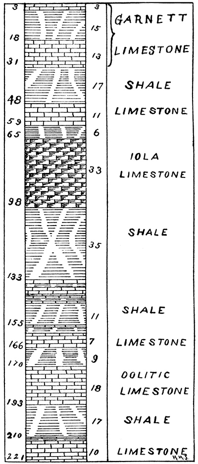
Going on up to the Soldiers' Home, and passing up the roadway from the station towards the buildings on the top of the hill, the little creek and a quarry or two which have been opened help to fix the location of the limestone. On the top of the hill is a ferruginous brecciated limestone 2.5 feet thick which has been quarried, somewhat. Then descending there is a slope of 58 feet 8 inches from the top of this limestone to the top of the upper of the two systems seen at the crusher farther down the river. The upper system has been somewhat extensively quarried here, and is from 11 to 13 feet thick. Next below it, and separated by five feet of brown, dark and bituminous shales; lies an even-bedded--sometimes in one, again in two layers--drab limestone, which has been quarried here. In the clays immediately below this there is an abundance of Derbya (Hemipronites) crassus, in good preservation. Below this is a 10-foot slope before the top of the, second limestone Is reached. The top of this latter system only is seen here and but 14 feet above the railroad track at the depot.
The upper of these two limestone systems here contains Spirifer lineatus, Athyris subtilita, Archaeocidaris spines, Productus prattenianus, and Fusulina cylendrica. The thin, even-bedded layer contains Pinna ——, Chaenomya leavenworthensis, and Myalina subquadrata. Brick clays are also found in this neighborhood from which brick has been made for the buildings in the Home. There are fine springs here in connection with both limestone systems
Section at Soldiers' Home
Between the Soldiers' Home and Leavenworth the upper Garnett limestone lies in a bold cliff above the railroad track, and frequently the even-bedded layer below it comes into view.
About half a mile down the river from the union depot in Leavenworth a good section of this rock with its accompanying thin layers above and below is to be seen as follows. Beginning at the top there is:
| 1--Arenaceous limestone, 1 foot five inches. | |
| 2--Drab shales, 11 inches. | |
| 3--Limestone. | 1 foot 2 inches. |
| 4--Clay parting. | |
| 5--Limestone. | |
| 6--Argillaceous limestone, 2 feet. | |
| 7--Gray limestone, 12 feet. | |
| 8--Dark bituminous and clay shales, 4 feet 6 inches. | |
| 9--Fucoidal and fossiliferous limestone, 2 feet. | |
| 10--Slope, 4 feet to railroad grade. | |
In comparing the above section with Meek and Hayden's section at Leavenworth landing; made in the summer of 1858, there is a very strong agreement, even to the locating of the fossil Derbya (Orthisma) crassa, found 80 abundantly in the thin limestone first below the upper Garnett rock. [Pro. Acad. Nat. Sci., Philadelphia, vol, 11, p. 8.] Other fossils mentioned by Meek and Hayden were also found.
Swallow gives a general section of the rocks of eastern Kansas [Prel. Rep. Kansas Geol. Survey, pp. 9-29; Lawrence, 1866], and in what he calls the "well-rock series," mention is made of those occurring at Leavenworth, but evidently when he p.laces coalsNo. 176 of his section-which are found in the Lawrence shales, below the Garnett limestone, he considers the Oread and Garnett as equivalent, which we now know, by closer observation than he could give them, are not. The Oread limestones are above and the Garnett limestones below the Lawrence shales. According to the correlation of this Survey, the heavy limestone near the base of the hills at Leavenworth corresponds to the Garnett and these on the hilltops at the Reservation to the Oread limestone. Between them, however, are two, if not more, thin limestone systems, one of which at least occurs in the Lawrence shales, in the vicinity of Lawrence. They seem to thicken northward, so that they are very much heavier around Leavenworth.
From the Union depot northward in Leavenworth to a creek on the south end of Military Reservation, two miles away, the railroad track lies on a bench formed by the upper Garnett limestone. The last seen of this limestone, before it dips below the river, is on this creek, and the west abutment of the Rock Island railroad bridge which spans the Missouri river here, is built upon it. Above it along the bench already spoken of, between the Union depot and the south end of the reservation, are heavy beds of arenaceous shales with many thin, broken layers of sandstone dipping in all directions in them, but mainly dipping where exposed to the south.
At the west end of the Rock Island bridge along that road is a cut exposing the ferruginous brecciated limestone, first seen at the Soliders' Home, which is here largely made up of communited shells. This rock is about six feet thick and crops out all along the bluff for a short distance towards the south and west and for a mile and a half to the north, on the Reservation, except where a small creek cuts it off for a short distance. It has been quarried extensively along the, outcropping edges for the heavy walls of the military prison.
The fossils of the above brecciated limestone are Chonetes verneuiliana, Orthis carbonaria, Productus longispinus, Lophophyllum proliferum, and Crinoid columns.
The section at the quarry worked by military prisoners, about a mile and a half above the Fort, shows this ferruginous rock to be 10 feet thick; and in addition to the above fossils of it and its associated shales and thin limestones, some distance above it, there are the following: Athyris subtilita, Spirifer plano-convexus, Derbya crasus, Euomphalus rugosus, Productus nebrascensis, Productus pertenuis, a small Pleurotomaria ——, Loxonema (?) ——, Phillipsia scitula, Rhombopora lepidodendroides, Retzia mormoni, Myalina recurvirostris, Spiriferina kentuckiensis, Astartella ——, Pleurotomaria sphaerulata, etc.
Two miles up the bluff from Fort Leavenworth there is found at about 42 feet above the railroad tracks a limestone some eight feet thick, which is to be seen all along the bluff in tumbled-down masses. Yet after being cut off by Salt creek a little farther along it was not again to be found in the bluff north of Kickapoo. The brecciated limestone of Fort Leavenworth section is, however, seen along and just above the railroad track until Kickapoo station is reached, where it becomes the foundation for the depot building; and two miles above Kickapoo it finally disappears beneath the valley.
Two miles above Kickapoo measurements were taken up a small creek, at the point where the brecciated limestone was last seen at the valley level, until a height of 227 feet was reached, and here the top of a heavy ledge came in sight. The water in the little creek has cut in many places to the shales, in situ., and in two places toward the top of the hill benches were observed which usually predicate a firm ledge either of limestone or sandstone, but nothing could be seen in either bench where the creek passes over them except loose limestone fragments. The limestone of the hilltop, however, proved to be the same as that found at the quarry opened by the military prisoners in the high ridge on the western part of the Reservation at Fort Leavenworth. It is the equivalent of Broadhead's No. 150 in Missouri, and, without question, of the Oread limestone of the Kansas river section (see chapter V1). On the Reservation its surface is far above that of the country in Missouri across the river. In Missouri it is not found until a point much higher up the river is reached. On the north end of the high ridge of the Reservation there seems to be a cropping of limestone about 12 feet below this heavy rock, which may be the equivalent of the lower Oread limestone, and also the thin, even bed, which is but five feet below the heavy rock at Atchison. Professor Knerr gives the limestone in his Atchison section (chapter VIII), which I failed to see, and which he makes to lie yet below the even bed some few feet, unless the little exposure seen immediately above the coal mine, two miles down from Atchison, were it. In taking measurements on the side of a bluff often there is danger of error on account of portions of the limestone having moved downward more or less by the wearing away of the underlying shales. Therefore the separation at the Reservation might not have been as much as 12 feet. The Oread limestones at Lawrence, and west of there, are 20 feet apart. On the Missouri side of the river, before No. 150 of Broadhead is reached, in the upward survey, two limestone systems come in below this heavy limestone which are separated by about 20 and 50 feet of shales, etc., respectively. The benches two miles above Kickapoo may be formed by these thin systems, which in Missouri nowhere reach a thickness greater than seven feet.
The fossils of this limestone here are: Spirifer cameratus, Athyris subtilita, Allorisma subcuniata, Allorisma granosa, and others.
At Oak Mill station,. a mile and a half above the last mentioned section, the Oread limestone has been quarried somewhat in the tops of the hills. It is here a light gray in color and 15 feet of it was exposed by the quarrymen. It is, however, thicker here than this. The fossils in it were: Chonetes granulifera--a shell found more abundantly as we ascend geologically--Spirifer kentuckiensis, Zeacrinus macrospinus, Zeacrinus acanthophorus, Archaeocidaris spines, Orthis carbonaria, Cyathaxonia distorta, etc.
Going on to a point one and a half miles above Oak Mills the sand rock of the section three miles down the river is here seen at the water's edge, and the shales immediately above it for 20 or more feet contain many fine fossils. These shales are the equivalent of Broadhead's No. 125 of western Missouri, where they are also filled with the same fossils. The fossils are: Myalina subquadrata, Myalina recurvirostris, Bellerophon bicarinatus, Nucula ventricosa, Astartella ——, Lophophyllum proliferum, Athyris subtilita, Bellerophon carbonaria, Schizodus ——, Productus americanus, Productus nebrascensis, Edmondia ——, Crinoid columns, Pleurotomaria broadheadi, and three other Pleurotomarias, Euomphalus rugosus, Derbya crassa, Polyphemopsis nitidula, Leda (Nucula) bellistriata, Chonetes granulifera, Turritella ——, Zeacrinus macrospinus, Zeacrinus acanthophorus, Orthis carbonaria, Spirifer plano-convexus, etc.
It is worthy of note here that few of our shales carry fossils, except where there are thin layers of carbonaceous matter in them; yet here we have a seemingly mixed arenaceous and carbonaceous clay shale charged with perfect specimens of Molluscan exuvia, among which Lamellibranchs and Gasteropods predominate. There is a blue day shale in Kansas City, Mo., lying below the Iola limestone, which contains many fine Crinoidia and Molluscan remains; but the same shale in other places fails almost entirely to yield any fossils. A few other of the bituminous shales of Kansas City yield three or four species of fossils. This fact is noted in describing the Kansas City and neighboring rocks.
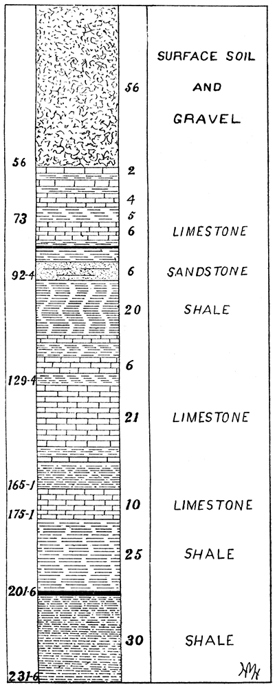
From the last mentioned point, for about six miles up, and along the Missouri river, the bluffs are low close to the side of the stream and consequently nothing was seen of our heavy top rock, or any other stratum, until the coal mine two miles below Atchison was reached. There is an 11-inch vein of coal worked here by drifting into the side of the bluff which overhangs the river valley. The coal seam is 14 feet above the railroad track, and 16 feet above this coal about 2 1/2 feet of limestone appears. Some distance above this limestone the perpendicular escarpment seen through the underbrush would indicate that our heavy limestone was there, were it not to be seen a little farther on up the river. One mile down from Atchison union depot and at intermediate points, quarries are worked, which give good opportunities to see the thickness, nature, etc., of the rocks passed. The quarry farthest down the river shows 21 feet of the heavy gray or Oread limestone (No. 150, Broadhead) and the same system as that found in the high ridge of the Fort Leavenworth Reservation. Above it here are six feet of blue and drab shales, then 5 feet 8 inches of even-bedded limestone of splintery fracture. About 5 feet below the Oread limestone here there is a bed of blue and bituminous shales, then an even-bedded layer of limestone from 2 to 2 1/2 feet thick. Here the base of the Oread limestone is 48 feet above the railroad grade, and at places arenaceous shales are exposed in this slope. The fossils of the Oread limestone are few here and of the common species. A quarter of a mile nearer the city is the Waggener quarry, where the Oread limestone is 22 feet thick. The first rock above, one-fourth of a mile away, which we have said was 5 feet 8 inches thick, is here but 8 inches thick at the south end of the quarry and thins out to nothing before the north end of the exposure is reached. Above this there are 20 feet of blue and drab shales, and then 3 feet of even-bedded limestone. Then above this 48 feet of slope, until a limestone 6 to 8 feet thick is reached. This we will provisionally call the Sea Urchin limestone on account of the quantities of Archaeocidaris spines which lie immediately above it in the clays. This would indicate that probably it is in the geologic horizon of the Topeka limestone. Above this again is a slope of 12 feet; then a thin limestone, from 1 to 2 feet. Above this Professor Knerr, of Midland College, Atchison, says that in the high hills of the neighborhood of Atchison two other systems or parts of one system are found. First above the last-mentioned rock are 2 feet of soft, bituminous shales, then 2 feet of limestone, then 2 feet of clay shales, and lastly 2 or more feet of limestone.
At the union depot in Atchison the Oread limestone is 21 feet thick, and its base 35 feet 9 inches above the railroad. Below it are first five feet six inches bituminous and blue shales, then the even-bedded limestone two feet three inches thick, and lastly the blue and drab shales to railroad grade. The Oread limestone here is somewhat oolitic near the top, but this may be the result of coalescence with the limestones above it. It also contains some chert in places, but this a characteristic of this great limestone bed wherever found.
Section at Atchison (Fig. 3, page 66.)
The fossils of the Oread limestone in and around Atchison are Fusulina cylindrica, Productus costatus, Retzia mormoni, Spirifer cameratus, Fenestella ——, Spirifer plano-convexus, Allorisma subcuneata, and Crinoida. The even-bedded limestone just below it abounds in Chonetes granulifera and also contains Productus nebrascensis, Productus costatus, Derbya crassa, Myalina subquadrata, etc.
Figure 3--Section at Atchison.
From Atchison to St. Joseph, Mo., the general trend of the Missouri river is northeast and southwest. Going up the river, therefore, from Atchison the strata crops out on an almost horizontal plane, on account of the generally uniform northwest dip. From Atchison, therefore, to Doniphan station, which is almost due north, the rocks dip but little and the Oread limestone at the latter place is just above the railroad track. Along the bluffs, therefore, until Deer creek is reached, where this marked limestone is cut off by the valley of that and Independence creeks at their confluence in the northeastern part of Atchison county, it is almost in a horizontal position, as seen everywhere along the bluffs.
After reaching Independence creek our section instead of going northeast along the river leaves the Missouri here and runs up the valley of Rock creek in a northerly direction, towards Troy Junction in Doniphan county. Leaving Doniphan station, on the Burlington & Missouri River railroad, the grade rapidly rises until Troy Junction is reached, but the rock stratum seems to rise with it. A mile above Doniphan station the Oread limestone is still to be seen in the bed of the creek, and not much below the level of the track. The base of it only is in sight, resting as usual on its slaty, bituminous, and clay shales, below which again is seen the even-bedded limestone. These bituminous shales here contain many small concretions; and a little below the even-bedded stratum, or first limestone below the Oread, are found in great abundance, Derbya crassa. Here also Chonetes granulifera, Myalina recurvirostris, and Myalina subquadrata, are found quite plenty.
Section near Doniphan
Two miles farther on up the grade, and three miles from Doniphan station, was found the first exposure where measurements could be taken; yet the ,benches formed by the Oread limestone could be seen for nearly two miles up the valley, above where last section was taken. Here a bluff was capped by a 15-foot system of limestone, immediately below which is 11 feet of buff and drab shales, then three feet of decaying limestone, then 50 feet of arenaceous shales, and 26 feet more of slope, bringing it down to the railroad grade. This upper limestone may be the equivalent of that which Professor Knerr reports as existing in the hilltops around Atchison. Three miles farther up the creek it comes about to the level of the rapidly ascending railroad grade, and is last seen in a west branch of Rock creek a mile or so above Brenner station.
Over the Divide
After leaving the point where the limestone last mentioned disappears the railroad grade raises rapidly to the summit of the divide at Troy Junction. This divide extends from southwest to northeast across Doniphan county and rests no doubt on a great anticlinal which gave contour in the early ages to the country and the course of the Missouri river. The river in first cutting its way from the northwest struck this and bent away to the east end of it before crossing it. After crossing it, the course of the river was to the south by what is now St. Joseph, Mo.; then it deflected back to the southwest towards the site of the city of Atchison. This gives Doniphan county a very extensive frontage on the river, being its boundary on the north, the east and part of the south. This divide was much added to by glacial drift, the deposit being of great depth on it, and above this till and gravel were deposited joint clays, of the Champlain Period, increasing its altitude. On the south side of this divide wells have been dug to a depth of 100 feet and more, and then ending where water was found among the loose sand and gravels. There was no stratified rock; boulders of granite and limestone alone being found, proving conclusively the drift origin of the upper deposits of this high divide.
After leaving Troy Junction the railroad heads in a northwesterly direction down one of the tributaries of Wolf river. The down grade is so great here that two miles before Fanning is reached the stratified rocks again come into view, yet not much exposed until that station is reached. Seventy-three feet above the railroad tracks the base of Broadhead's No. 186 is found here, and some little distance down the hillside loose limestone was found indicating that there was another system at this horizon.
North of Fanning a mile and three-quarters and one-half mile from Highland station, section 28, township 2 south, range 20, in a farmyard there is a good exposure of the heavy limestone of last section. It is here 13 feet thick. Below it is 4 feet of buff shales, then an even bed of limestone 2 feet thick; and below this 6 feet of drab shales, below which again is 1 1/2 feet of limestone, then a slope across a pasture lot of 20 feet to the railroad grade.
A mile and a half above Highland station and about directly west of Eagle Springs, is a quarry in the limestone close to the railroad tracks and but 9 1/2 feet above them, having also its first thin stratum in place below. Here it presents the usual characteristics as at Highland station, and a few fossils were taken from it here. There is a thick, uneven layer at the bottom, where are found a greater number of fossils. At this point it is a blue drab and in part crumbling limestone. The organic remains are Rhynconella uta, Lophophyllum proliferum, Fusulina cylindrica, Athyris subtila, Chaetetes ——, etc.
Northwest from this, near the railroad, in a barnyard, in section 7, township 2, range 20, this same heavy ledge is again exposed, and the bottom of the thin limestone here is about on a level with the railroad grade.
Farther on one mile, on section 6, at the point where the Missouri river was again reached, the same limestone lies just above the track. A little farther on, three-quarters of a mile from Iowa Point depot, on the Burlington & Missouri River railroad, a good exposure of this rock was found at the water's edge, and it was here 15 feet thick. The current of the Missouri river sets in here against it, and it forms a barrier to the usual rapid inroad of that stream. A good section was here taken of what was exposed of the lower thin system of limestones in the bluffs and overlying this heavy limestone system.
The 13-foot system here (No. 186, Broadhead; see Rep. Mo. 1872, pt. 2, p. 133,) contains fossils already noticed in it at Eagle Springs station. Above it was a slope of 28 feet, then 5 feet of limestone, somewhat argillaceous and parted in the middle by a heavy clay seam, then 11 feet of clay shales, except near the top, where they were bituminous, then 1 foot 6 inches of limestones with calciferous shales above it for some distance before a heavy joint clay deposit was reached, which joint clay extended to the top of the bluff.
The calciferous shales and top limestone contain Chonetes granulifera, Bryazoans, Fistulipora nodulifera, Rhombopora lepidodendroides, Productus nebrascensis, Spirifer cameratus, Terebratula bovidens, Athyris subtilita, Archeodaris spines, and Crinoid columns.
The 5-foot limestone contains: Zeacrinus macrospinus, Zeacrinus acanthophorus, Athyris subtilita, Retzia mormoni, Spirifer cameratus, Productus costatus, Productus prattenianus, and Chonetes granulifera.
On the face of the hill and in the heavy rock were found; in addition, Productus semireticulatus, Orthis robusta, Cyathaxonia distorta, Chaetetes ——, Lophophyllum infundibulum (?), Fusulina cylindrica, Rhynchonella uta, and Naticopsis wheeleri.
A few rods east of the depot at Iowa Point there is a good exposure of the thin systems which lie above the heavy limestone. This rock, which was exposed along the levee when the place was first settled, is now under a cultivated field on the river bottom land. The river bank is now nearly a mile away from the old landing of the early days.
Section at Iowa Point
From Iowa Point to White Cloud, and in fact to the Nebraska line, very little is seen except the vast hills of joint clay, and these the most extensive of any found along the Missouri river in Kansas. At White Cloud are two thin seams of limestone, one just above the valley and close to the railroad track, 2 feet thick, in two layers, and an even-bedded layer, close to the water's edge, 16 inches thick, which were the equivalents of upper layers at Iowa Point. Above White Cloud, for a mile or more along the bluffs, there were above these limestones somewhat heavy beds of drab clays, in which were thin seams of sandstone. The glacial drift lies on these shales, and above all are immense bluffs of joint clays rising from 200 to 300 feet.
As can be seen, the line of our section left the Missouri river at Doniphan station, striking it again just below Iowa Point. A few observations, however, were made on the east side of the county, and also north of Troy, the county seat.
First, going down Mosquito creek directly north of Troy, to the Missouri river. About a mile from the town the first limestone is seen. On the top of the exposure two thin layers were visible, separated by about 2 feet of shales, then a little lower a 10-foot ledge of limestone (No. 186 of Broadhead), then a couple of miles or so farther down two other thin systems of limestone, 2 and 4 feet thick respectively. The 4-font ledge was but 10 feet above the water in the Missouri river, and 10 feet above that the 2-foot ledge, with shales above the latter.
Going on the downward grade of the Grand Island railroad, from Troy to St. Joseph, Mo., there are several exposures. One-half mile from Troy east is the heavy top rock of Brenner (No. 186, Broadhead). Five feet or so of it only could be seen. At Blair station the thin limestones below it are visible, West of Wathena one mile the heavy gray Oread limestone of Atchison appears in the railroad cut. At Wathena, a village on the river bluffs, the Oread rock is 110 1/2 feet above the railroad grade at the depot. In the quarry here but 15 feet of it were exposed. It has all the lithologic and paleontologic characteristics here; small quantitles of chert, and not many fossils, although various forms were found, and some few fossils in good preservation. This limestone is also present everywhere along the Missouri river in the bluffs from Atchison to Wathena and up to the point opposite Amazonia in Missouri. At Amazonia the river bends rapidly to the west, and this limestone is soon lost sight of in the general northwesterly dip, To determine the exact extent of its outcrop in Doniphan county, a more detailed survey must be had. At Amazonia, in Andrew county in Missouri, this limestone is well exposed. A mile and a half west of Amazonia station, on the Kansas City, St. Joseph & Council Bluffs railroad, there is immediately above this heavy limestone and separated by about 2 feet of shale, a somewhat oolitic stratum, 14 1/2 feet thick, which is the equivalent of the rock that pinches out entirely at the Waggener quarry at Atchison, and which lies there 4 feet above the heavy limestone deposit. But this is the peculiarity of some of the limestones, especially those of arenaceous and oolitic structure. They disappear and come in again in their proper place. For instance, the rock at the top of the smelter quarry at Argentine and the very top rock at Kansas City, Mo. (No. 1 of Kansas river section), appears but at few places. At Edwardsville, in Wyandotte county, it is in its proper place, but at Pomeroy, in the same county, it is not seen, nor at Quindaro, while at Connor there is a small outcrop of it, and also another at Ross, in Leavenworth county.
All the thinner systems also are subject to this want of persistency, although not in so marked a degree; but the heavy systems, and especially the gray limestone, are of a very great lateral extent and nearly of uniform thickness.
A few general remarks may be made here on the section from Kansas City to the Nebraska line. After leaving the Kansas City systems of limestones, the two heavy deposits, as seen in figure 3, outcropping at the Soldiers' Home and south of there are undoubtedly the equivalent of the Garnett systems, only that the lower of the two is not as thin as the same at Eudora, and agrees with it more as it appears at Olathe in point of thickness, and the characteristic fossil, Syntrialasma hemiplicata was not seen in it. The lower, however, we are now persuaded, is the same as the Plattsburg system of Broadhead--his No. 108--and the upper, his No. 112.
The ferruginous brecciated limestone of the lower quarries of Fort Leavenworth may be the continuation of the thin limestone system in the- Lawrence shales, seen at the horizon of that town. The upper Oread and the heavy limestone of Atchison must also be considered as equivalents.
Plate II--A Geologic Section extending near the east side of the state along the Kansas City, Fort Scott & Memphis railway from Baxter Springs to Kansas City, and from Kansas City along the west bank of the Missouri river to the north side of the state.
By Haworth and Bennett; to accompany Chapter II.
Scale: Vertical, 1 inch equals 500 feet; horizontal, 1 inch equals 5 miles.
The limestones are represented by the conventional masonry.
The shales and sandstones are left bare.
The surface contours are taken partly from railroad levels and partly from the United States Geological Survey Topographic sheets.
Available as an Acrobat PDF, 4.3 MB.
Prev Page--Chapter I || Next Page--Chapter III
Kansas Geological Survey, Geology
Placed on web June 1, 2017; originally published 1896.
Comments to webadmin@kgs.ku.edu
The URL for this page is http://www.kgs.ku.edu/Publications/Bulletins/Vol1/chapt2.html