Kansas Geological Survey, Technical Series 20, originally published in 2006
Originally published in 2006 as Kansas Geological Survey Technical Series 20. This is, in general, the original text as published. The information has not been updated. An Acrobat PDF file containing the complete report is available (26.4 MB); plates available separately. Cover image is Big Basin in Clark County, Kansas.
Development of tailored ground-water-management plans for the Ogallala portion of the High Plains aquifer in western Kansas calls for a more accurate assessment of the water table and bedrock-surface-elevation data used to calculate saturated thickness. Until this most recent effort, bedrock-surface elevation beneath the Ogallala aquifer in western Kansas was known only from a map based on data collected up through about 1980. Since then, new data have become available for the thousands of wells that have been drilled for water and hydrocarbons in western Kansas and in the adjacent townships of Nebraska, Colorado, and Oklahoma. Out of more than 40,000 records examined, a total of 22,535 data points were selected for inclusion in the bedrock-surface-elevation database for this project. Depth-to-bedrock information in Kansas was determined from interpretation of driller and gamma-ray logs or was provided from the WIZARD database. Data also were included from the surrounding states that border the Kansas Ogallala region. The data were entered into an ArcGIS geographic-information system from spreadsheets. A land-surface digital-elevation model was used to estimate a surface elevation and with depth-to-bedrock data, to estimate bedrock-surface elevation for each well location. Bedrock-surface elevations were plotted and manually contoured to produce the latest version (2004) of the bedrock-surface-configuration map.
Overall, bedrock-surface elevation across the Ogallala region is approximately 1 ft (0.3 m) lower than the previous map version, which is well within the error of the data used to create the updated map. Locally, the magnitude of the change in the bedrock-surface configuration is greatest in southwest Kansas, and the size of the areas where the change is greatest is larger in this region of the state than elsewhere. A visual comparison of the two map versions clearly shows that the increase in data used to produce the updated map has resulted in a concomitant increase in the level of topographic detail that can be shown.
A significant part of the process of producing the final updated bedrock map (Plate 1 A and 1B, envelope) involved investigation of the Crooked Creek-Fowler and Bear Creek faults that appear on earlier bedrock-surface-elevation maps. These features have previously been interpreted as continuous-fault zones associated with dissolution of evaporites in the Flower-pot Shale rather than dissolution fronts characterized by sinkholes, coalesced subsidence basins, and local faulting with minor displacement. The top of the Blaine Formation was chosen as a structural-mapping horizon to evaluate shallow geologic structure, and comparisons were made to the better-understood Hutchinson Salt Member dissolution zone in central Kansas. Results of the investigation suggest that the dissolution-front interpretation is more likely than the continuous-fault interpretation. Consequently, the fault traces on the bedrock were removed from the updated map, and the bedrock-surface-elevation data were re-contoured to reflect the dissolution-front hypothesis.
The updated map also provides insight into the Cenozoic drainage development of western Kansas in response to uplift of the Rocky Mountains to the west, isostatic rebound attributed to erosion of significant sediment thickness on the western Great Plains, and Quaternary climatically driven cycles of erosion, deposition, and stability. Pre-Ogallala drainage that included the ancestral Arkansas River entered Kansas from Colorado and exited the state approximately where the present-day Cimarron River enters Oklahoma. A southward-flowing tributary drainage followed the axis of the Scott-Finney depression to the main stem in southern Finney County. An incised paleovalley extending from eastern Gray, Ford, and Edwards counties seems to represent a post-Ogallala segment of the eastward-flowing ancestral Arkansas River drainage.
State and local water agencies are developing tailored management plans in response to continued water-level declines in the Ogallala portion of the High Plains aquifer in western Kansas. Success of these tailored management plans will depend on an accurate characterization of the remaining saturated thickness of the aquifer over the entire western Kansas Ogallala region. Aquifer saturated thickness is calculated as the difference between the water-table and bedrock-surface elevation. If the aquifer saturated thickness and the intensity of pumping are known, estimated usable lifetime of the aquifer for irrigation can be calculated. Aquifer subunits can also be delineated and prioritized from the usable lifetime and other data.
Aquifer saturated thickness is updated annually from depth-to-water measurements taken in a network of irrigation, stock, and observation wells distributed across the Ogallala aquifer. However, until this most recent effort, bedrock-surface elevation beneath the Ogallala aquifer in western Kansas was known only from a map produced in the mid-1980's by the U.S. Geological Survey (USGS) based on depth-to-bedrock data collected up through about 1980. A brief history of efforts to map the bedrock-surface elevation beneath the Ogallala is provided in this report.
With current management emphasis on aquifer subunits, detailed information on topography of the bedrock surface beneath the Ogallala is critical to produce a more accurate portrayal of the variation in ground-water availability. The increased level of detail in the updated map of bedrock-surface elevation is achievable because of the subsurface geologic data from the thousands of boreholes drilled for water and hydrocarbons throughout the Ogallala region in the 1980-2004 period.
The new map is a product of projects undertaken by the Kansas Geological Survey (KGS): the "Enhancement of the Bedrock Surface Elevation Beneath the Ogallala Aquifer," funded by the GIS Policy Board, and the "Update of the Bedrock Surface Elevation Map in Southwest Kansas Groundwater Management District 3," funded by Southwest Kansas Groundwater Management District 3 (GMD 3). Geographic Information System (GIS) Policy Board funding supported mapping of the entire western Kansas Ogallala region using driller logs from the WWC-5 water-well records submitted to the Kansas Department of Health and Environment (KDHE) from 1975 up through February 2004, the test-hole logs in the county geologic bulletins published generally in the 1930's and 1970's, and data from the USGS and agencies of neighboring states. Funding from GMD 3 was provided to increase the level of detail by including test-hole logs from water-well contractors and gamma-ray logs of wells drilled for oil and gas.
This report documents the process by which the updated bedrock-surface-elevation map was created and presents a paleo geomorphic interpretation of the bedrock surface. Also included is a section evaluating two alternative explanations for the Bear Creek and Crooked Creek-Fowler zones in the subsurface of southwest Kansas. This additional section of the report is germane to the updated map because of the impact these disturbed zones have on mapping of the bedrock-surface topography.
The authors want to especially recognize the contributions that were made to our research by Stephanie Lindsay. Stephanie assisted with data collection, sorting, entry into spreadsheets, and overall data management. Our work would not have been completed in a timely manner without her support and effort.
We wish also to express our gratitude to Henkle Drilling and Supply. Bruce Reichmuth allowed us to peruse Henkle's massive collection of driller logs and provided us with office space in which to do our work in Garden City. We also wish to recognize the contributions that Ed Gutentag made to our research.
The authors would like to recognize the contributions made by our colleagues to improve the quality of this paper. Discussions with Lynn Watney concerning salt-dissolution tectonics were helpful in formulating our ideas about the shallow geologic structures in western Kansas. Subsurface data on the elevation of the Blaine Formation top and thickness were provided by Melissa Moore. Mark Schoneweis provided assistance with several of the figures that appear in the manuscript. Lynn Watney and Dan Merriam reviewed an early draft of this paper and provided helpful comments. Marios Sophocleous, Bill Johnson, and Wayne Bossert reviewed the manuscript, and we greatly acknowledge their contributions to this most recent draft.
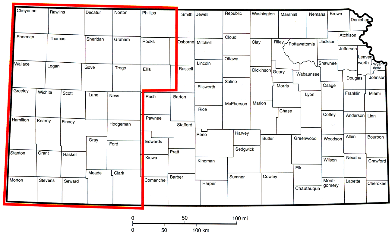
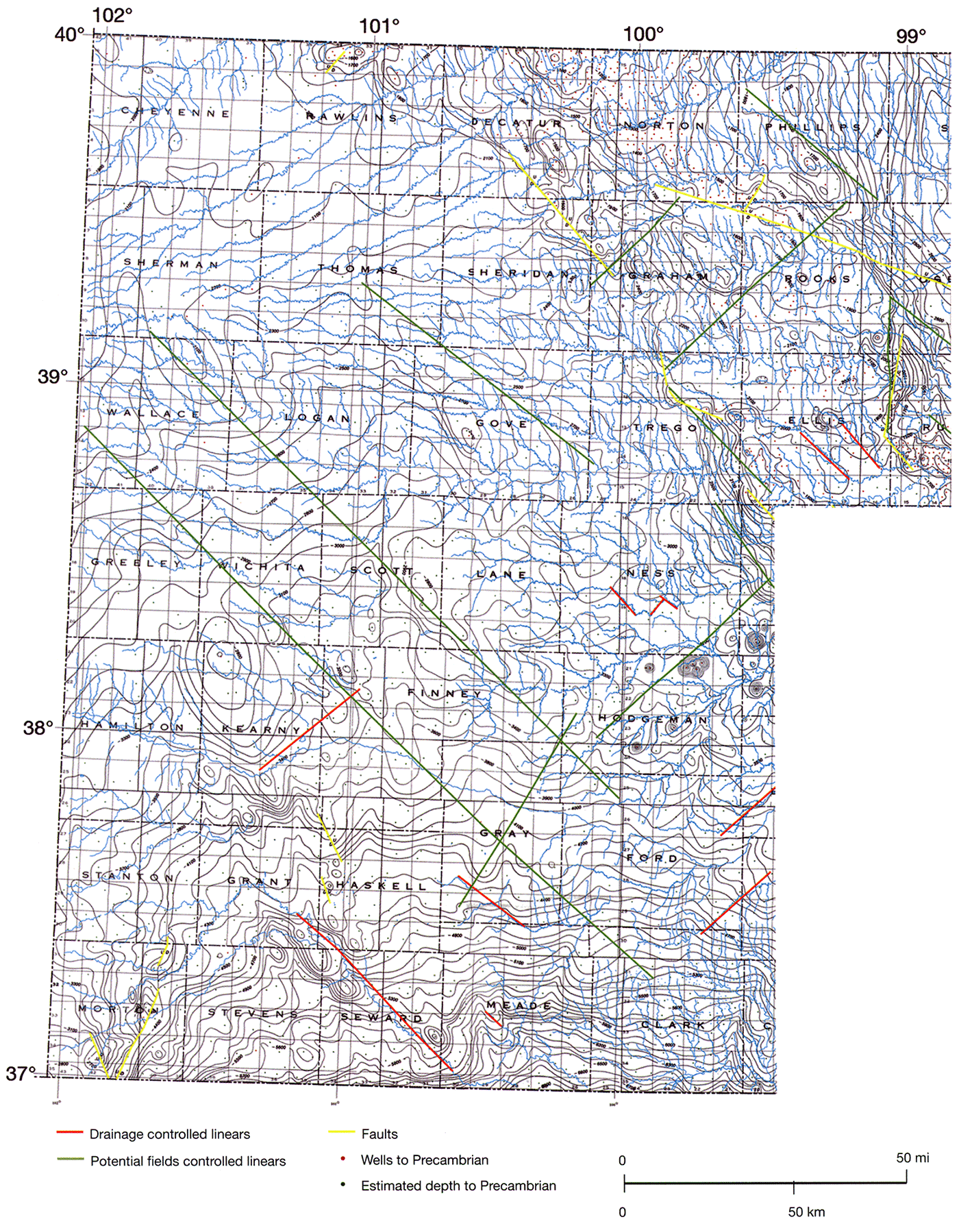
The project area includes portions or all of the counties in the western third of Kansas (fig. 1). Mapping of the bedrock-surface elevation was extended by two townships northward into Nebraska and southward into Oklahoma, and by two ranges westward into Colorado to ensure continuity of mapping across state boundaries.
Figure 1—Extent of the study area in western Kansas and adjacent parts of Oklahoma, Nebraska, and Colorado.
The Ogallala aquifer framework (table 1) consists of a heterogeneous assemblage of unconsolidated-to-cemented, Miocene-Pliocene deposits of gravel, sand, silt, clay, freshwater limestone, marl, and volcanic ash overlain by dominantly finer-grained, undifferentiated Quaternary eolian and fluvial sediments (Smith, 1940; Frye et al., 1956; Merriam, 1963; Gutentag, 1981). Cemented layers within the Ogallala Formation and undifferentiated Quaternary consist primarily of caliche and cemented sandstones. Silcrete-cemented layers occur in the lower part of the Ogallala.
What is known of the stratigraphy of the Cenozoic deposits in western Kansas comes from study of scattered surface exposures across western Kansas and mostly as part of the county-scale investigations conducted by the Kansas Geological Survey (KGS) and the U.S. Geological Survey (USGS) from the 1940's to the 1970's. Classification has depended largely on the dating of preserved fossil material and volcanic ash beds and recognition of unconformities (Bayne, 1976). Some authors have extended this classification into the subsurface using the lithology of the deposits as the defining characteristic (see for example Fader et al., 1964). However, because of the paucity of dateable material retrieved during test-hole drilling, results are untested and may be unreliable.
In northern Kansas, the Ogallala is subdivided into three members, from oldest to youngest: the Valentine, the Ash Hollow, and Kimball (Frye et al., 1956; table 1). Boundaries between the members are indistinct and recognized on the basis of preserved fossil seeds.
Table 1—Stratigraphic column of surface and shallow-subsurface geologic units in the study area (after Zeller, 1968).
| System | Series | Group | Formation | Member | |
|---|---|---|---|---|---|
| Neogene | Quaternary subsystem |
Holocene | Undifferentiated | ||
| Pleistocene | |||||
| Tertiary subsystem |
Miocene-Pliocene | Ogallala Formation | Kimball | ||
| Ash Hollow | |||||
| Valentine | |||||
| Cretaceous | Upper Cretaceous | Montana | Pierre Shale | ||
| Colorado | Niobrara Chalk | ||||
| Carlile Shale | |||||
| Greenhorn Limestone | |||||
| Graneros Shale | |||||
| Lower Cretaceous | Dakota Formation | ||||
| Kiowa Formation | |||||
| Cheyenne Sandstone | |||||
| Jurassic | Upper Jurassic | Morrison Formation & Dockum Group undifferentiated |
|||
| Triassic | Upper Triassic | ||||
| Permian | Guadalupian | Big Basin Formation | |||
| Day Creek Dolomite | |||||
| Whitehorse Formation |
|||||
| Leonardian | Nippewalla | Dog Creek Formation | |||
| Blaine Formation | |||||
| Flower-pot Shale | |||||
| Cedar Hills Sandstone |
|||||
| Salt Plain Formation | |||||
| Harper Sandstone | |||||
| Stone Corral Formation |
|||||
| Ninnescah Shale | |||||
| Sumner | Wellington Formation |
Upper | |||
| Hutchinson Salt | |||||
| Lower | |||||
| Wolfcampian | Chase | Nolans Limestone | Herington Limestone |
||
In southwest Kansas, the three northern Kansas members of the Ogallala Formation have not been recognized (table 2). Boundaries between units are indistinct and recognized on the basis of dateable material from preserved ash falls and vertebrate fossils. In Meade County, Frye (1942) subdivided the Tertiary deposits into a lower Pliocene-upper Miocene Laverne formation and the upper and middle Pliocene Ogallala Formation. In turn, the Ogallala Formation was subdivided into a lower unnamed member and an upper member, the Rexroad. In Ford County, Waite (1942) assigned all the Tertiary deposits to the middle and upper Pliocene Ogallala Formation. The Ogallala was further subdivided into two members following Frye (1942). In Finney and Gray counties, Latta (1944) subdivided Tertiary deposits into a lower Pliocene-upper Miocene Laverne formation and a Pliocene Ogallala Formation. Later, Byrne and McLaughlin applied Frye's (1942) classification to Tertiary deposits in Seward County. Hibbard (1953, 1958) and Hibbard and Taylor (1960) subdivided the Pliocene Ogallala into three formations, which are from oldest to youngest: the Laverne formation, the Ogallala Formation, and the Rexroad formation. In the KGS county bulletins of the other southwest Kansas counties, Tertiary deposits have been assigned to the Pliocene Ogallala Formation. More recently, Izett and Honey (1995) conducted a detailed surface-geologic investigation in the Irish Flats 7 1/2-minute quadrangle near the center of Meade County. They assigned most of the Tertiary deposits to three units, which are from oldest to youngest: the Miocene Ogallala Formation, the Pliocene Rexroad formation, and the Pliocene Stump Arroyo member of the Crooked Creek formation (table 2). The Huckleberry Ridge ash bed belongs to the upper unnamed member of the Crooked Creek and is also Pliocene in age. The Pliocene-Pleistocene boundary in the Crooked Creek is not distinct but is located between the Pleistocene Cerro Toledo B and Pliocene Huckleberry Ridge ash beds.
Table 2—Stratigraphic classification of Cenozoic deposits above the bedrock surface in southwest Kansas.
| System | Series | Grant & Stanton counties (Fader et al., 1964) |
Meade County (after Hibbard, 1953, 1958; Hibbard and Taylor, 1960) |
Irish Flats NE quadrangle Meade County (Izett and Honey, 1995) |
||||
|---|---|---|---|---|---|---|---|---|
| Neogene | Quaternary subsystem |
Holocene | Alluvium/ upland deposits |
|||||
| Pleistocene | Sanborn Group |
Vanhem formation | Basin-fill deposits | |||||
| Kingsdown formation | ||||||||
| Pearlette ash bed Lower Pleistocene |
Meade group | Crooked Creek formation |
Atwater member | Crooked Creek Formation |
Upper unnamed member Lava Creek B ash bed Cerro Toledo B ash bed Huckleberry Ridge ash bed |
|||
| Pearlette ash lentil | ||||||||
| Stump Arroyo Member |
Stump Arroyo Member |
|||||||
| Ballard formation |
Missler Member | |||||||
| Angell member | ||||||||
| Tertiary subsystem |
Upper Miocene Pliocene |
Ogallala formation | Rexroad formation | |||||
| XI Member | ||||||||
| Ogallala Formation | Rexroad formation | |||||||
| Laverne formation | ||||||||
| Ogallala Formation | ||||||||
Deposits assigned to the Quaternary are currently subdivided into the undifferentiated Pleistocene series and the undifferentiated Holocene series in northern and southwest Kansas (see for example the recent KGS-completed western Kansas county surface-geology maps at http://www.kgs.ku.edu/ General/Geology/index.html). Surface mapping units within the Quaternary deposits are defined on the basis of depositional agent, geomorphic expression, or radiocarbon age and include dune sands, loess, terrace, and alluvial deposits.
The extreme variability in lithology of the Ogallala Formation suggests a variety of depositional environments. Concerning the Ogallala's origins, Smith (1940) and later Frye (1970) concluded that Ogallala sediments were (1) deposited on a dissected, piedmont surface that was undergoing uplift along the Rocky Mountain front; (2) derived primarily from the southern and central Rocky Mountains of northern New Mexico, Colorado, and Wyoming; and (3) deposited primarily by fluvial rather than eolian processes in response to climatic and tectonic factors. Diatomaceous, freshwater limestones and marls near the bottom of the formation indicate deposition in a lacustrine environment (Frye, 1942).
In contrast, Quaternary sediments were (I) deposited on a dissected landscape undergoing the waning stages of differential uplift that began in the late Pliocene, (2) derived from local sources, and (3) deposited by fluvial and eolian processes in response to primarily climatic factors (Frye and Leonard, 1952; Trimble, 1980; and Osterkamp et al., 1987).
The bedrock surface beneath the Ogallala aquifer is underlain by northward-dipping Cretaceous and northeastward-dipping Late Permian units (table 1 and fig. 2). Late Permian units subcrop beneath the Ogallala in southwest Kansas and include, from oldest to youngest: the Whitehorse Formation, the Day Creek Dolomite, and the Big Basin Formation (Gutentag et al., 1981). Strata assigned to the Jurassic Morrison Formation or the undifferentiated Jurassic-Triassic subcrop beneath the Ogallala aquifer in parts of Morton, Stevens, and Grant counties in southwest Kansas (Gutentag et al., 1981; Macfarlane et al., 1993). Early Cretaceous units subcrop beneath the Ogallala and include, from oldest to youngest: the Cheyenne Sandstone, the Kiowa Formation, and the Dakota Formation. These units form a subcrop belt that extends across the middle of GMD3. To the north, the subcrop belt of Late Cretaceous units includes, from oldest to youngest, the Graneros Shale, the Greenhorn Limestone, the Carlile Shale, the Niobrara Chalk, and the Pierre Shale. Late Cretaceous rocks form the bedrock beneath the Ogallala in the northern part of the southwest Kansas area and all of the west-central and northwest Ogallala areas.
Figure 2—Bedrock units underlying and Holocene alluvial deposits overlying the Ogallala Formation in western Kansas.
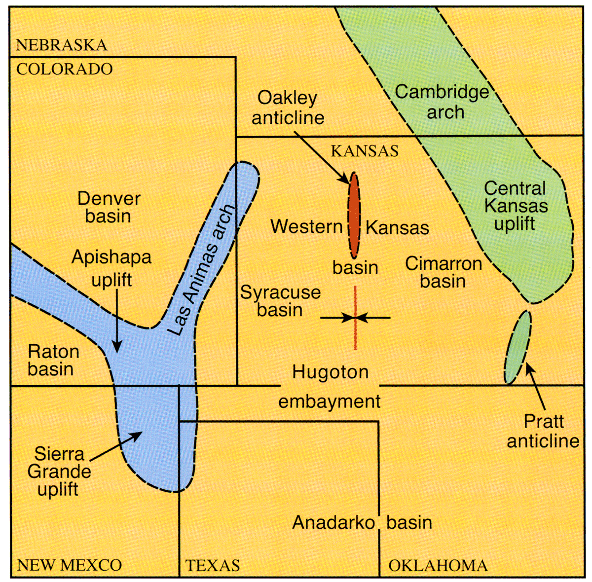
Regional geologic structures that are of significance in this report include the Western Kansas basin, the Syracuse basin, the Scott-Finney depression, the Las Animas arch, the Oakley anticline, the Hugoton embayment, and the Sierra Grande uplift (figs. 3 and 4). Geologic units that underlie the bedrock surface beneath the Ogallala dip northward and northeastward away from the Sierra Grande uplift into the Western Kansas basin. The Syracuse basin is bounded on the east by the Oakley anticline and on the west by the Las Animas arch (fig. 3; Mudge, 1967). The Scott-Finney depression is an elongate structural low that extends along the Syracuse basin east flank and may have formed as a result of post-Permian evaporite dissolution (fig. 4).
Figure 3—Major elements of the western part of the central Great Plains that were structurally active during late Paleozoic and the Mesozoic time (compiled from Merriam, 1963, and McKee et al., 1967).
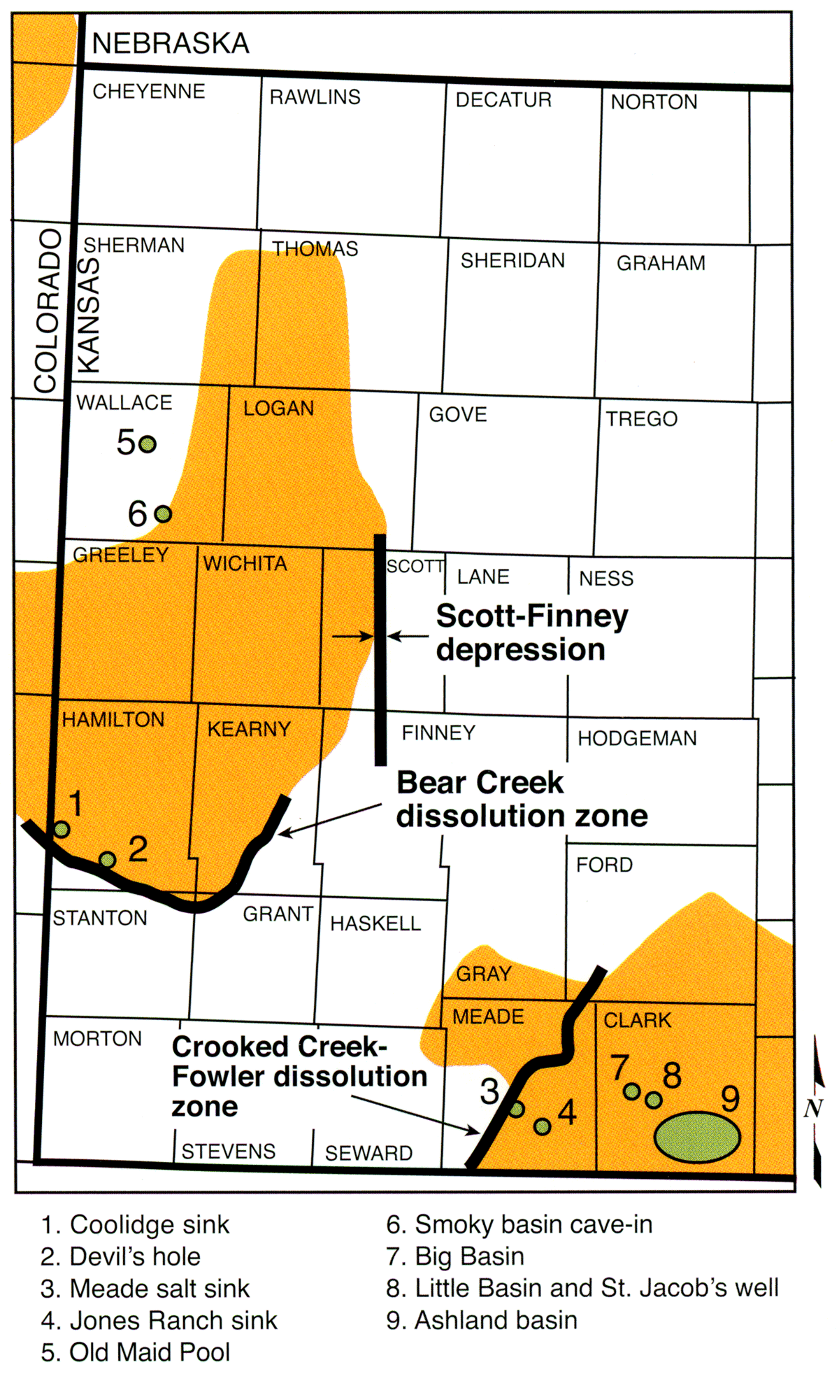
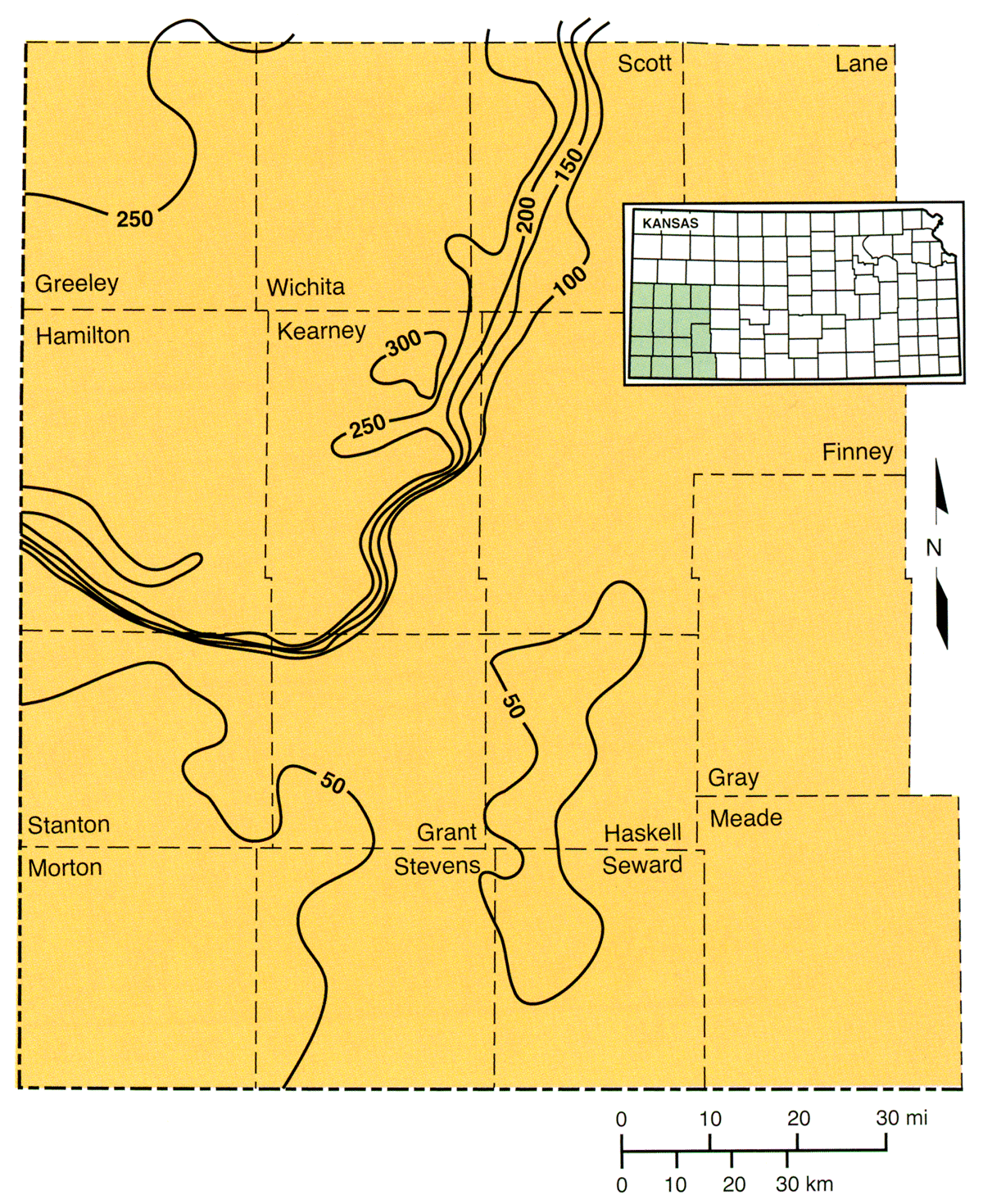
Smaller structures related to evaporite dissolution in the Permian Blaine and Flower-pot shales include the Crooked Creek-Fowler and Bear Creek fault zones and other naturally occurring, local, named and unnamed features (fig. 4). The Crooked Creek-Fowler and Bear Creek fault zones have been considered continuous faults in previous reports, including Frye (1941, 1942), Merriam (1963), Gutentag et al. (1981), and Spinazola and Dealy (1983). However, work completed for this report suggests that an alternative interpretation of the structural geology is more likely. Other naturally occurring, local structures related to evaporite dissolution occur primarily in southwest Kansas where the Ogallala aquifer rests on Permian bedrock units. Named features include the Meade salt sink and the Jones Ranch sink in Meade County; Little Basin, St. Jacob's well, Big Basin, and Ashland basin in Clark County; and Devil's hole and the Coolidge sink in Hamilton County (Merriam, 1963). Bear Creek drainage ends in a line of sinkholes associated with what has been called the Bear Creek fault in Stanton County. Smith (1940) associated the Coolidge sink with the fault.
Figure 4—Named geologic structures and karst features that have resulted from the dissolution of evaporites in the Flower-pot Shale. The approximate extent of areas where evaporites dominate within the Flower-pot are shown on the figure using color (compiled from Merriam, 1963; Rascoe and Baars, 1972; and Holdoway, 1978).
Beginning with production of the KGS "geology and groundwater resources of …"series of county bulletins in the early 1940's, periodic attempts have been made to develop and update information on the elevation of the bedrock surface beneath the High Plains aquifer in order to quantify available groundwater resources in the region of the aquifer under investigation. Through the mid-1970's, most of these bedrock-mapping projects were on the scale of at most a few counties and were based on limited test-hole drilling and reliable driller logs of boreholes drilled for water or hydrocarbons. Using the accumulated test-hole data, Merriam and Frye (1954) produced the first map of bedrock-surface elevation beneath the Cenozoic in Kansas and a suite of maps depicting variation in thickness and lithofacies within the Ogallala. In 1975, the Kansas Department of Health and Environment began requiring water-well-drilling contractors to submit records from constructed water wells to the State of Kansas on WWC-5 forms. These records include a driller's log of the borehole drilled for the completed water well, resulting in a wealth of subsurface information on the depth to bedrock from land surface.
The first regional study of the Kansas part of the High Plains aquifer that involved mapping of the bedrock-surface elevation was reported in Camp Dresser and McKee, Inc. (1979), O'Connor and McClain (1981), and Camp Dresser and McKee, Inc., Black and Veatch, and A. D. Little, Inc. (1982) for the U.S. Department of Commerce as part of a six-state study of Ogallala water resources. At about this time, results of a subregional investigation of the High Plains aquifer in southwest Kansas were reported in Gutentag et al. (1981). Elevation of the bedrock surface was mapped using the accumulated data from WWC-5 driller logs, test-hole logs of water-well contractors, test-hole logs reported in the KGS county bulletins, and the gamma-ray logs of wells drilled for hydrocarbons. In the mid-1980's, the USGS undertook a regional multi-state hydrogeologic study of the High Plains aquifer through the High Plains Regional Aquifer Systems Analysis (RASA) program. As part of the program, a new map of the elevation of the bedrock surface beneath the High Plains aquifer in Kansas was created by merging the O'Connor and McClain (1981) and the Gutentag (1981) maps and was published in Stullken and Watts (1985). A digital version of the Stullken and Watts map was produced by the USGS in 1995 and submitted to the Data Access and Support Center (DASC) as part of a GIS Policy Board-funded project to characterize extent, thickness, and overall water quality of the regional aquifers in Kansas (Hansen and Juracek, 1995). From 1998 to 2004, localized, onthe-fly, ad hoc revisions were made to the statewide elevation of the bedrock-surface map and were documented as the need for revision arose.
In this project, sources of data used to produce the 2004 bedrock-surface-elevation map (Plate 1A and 1B, envelope) included driller logs from WWC-5 records of water wells completed since 1975 and maintained at the KGS; test-hole logs from the files of Henkle Drilling and Supply Co., Garden City; test-hole logs from the KGS county bulletins; gamma-ray logs of boreholes drilled for oil and gas maintained at the KGS; records of wells in the KGS WIZARD/USGS GWSI database; and records of wells drilled in the two northernmost townships in Oklahoma from the Oklahoma Water Resources Board, the two southernmost townships in Nebraska from the Nebraska Department of Natural Resources' Data Bank, and the two easternmost ranges in Colorado from the National Water Information System (NWIS) database maintained by the USGS.
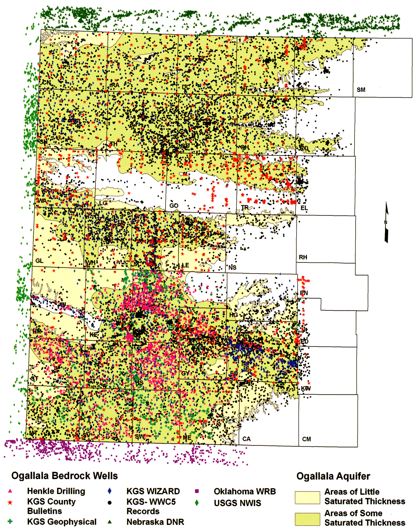
A driller's log was selected preliminarily for inclusion in the depth-to-bedrock database if it appeared from the narrative description that the borehole penetrated the bedrock surface. Out of more than 40,000 records examined, 13,662 WWC-5 driller logs, 2,670 Henkle test-hole driller logs, and 1,053 test-hole driller logs from the KGS county bulletins were added to the database. Six hundred and sixty-five gamma-ray logs were selected for subsurface correlation of the bedrock units and to provide estimates of the depth to bedrock if the top of the logged interval began within 100 ft of the surface and extended below the interval of the Permian Stone Corral Formation. Depth-to-bedrock data from 1,381 well records in the WIZARD well database also were selected. Overall, a total of 22,535 data points were selected for inclusion in the bedrock-surface-elevation database for this project (fig. 5).
Figure 5—Distribution and type of data used to map the elevation of the bedrock surface beneath the Ogallala aquifer in western Kansas. To maintain continuity of interpretation across state lines, bedrock-elevation data from Oklahoma (purple), Colorado (light green), and Nebraska (dark green) were included.
Depth-to-bedrock-from-surface estimates were made based on the description of the cuttings retrieved from the drilling of each depth interval listed on the log. Depth-to-bedrock estimates could not be made in cases where there was insufficient detail, because the cuttings descriptions were ambiguous, or the depth interval that included the bedrock surface was too large to reasonably estimate its depth. In the northwest and west-central parts of Kansas and the northern part of GMD 3, bedrock beneath the Ogallala aquifer is shale or chalk assigned to the Graneros Shale, the Greenhorn Limestone, the Carlile Shale, the Niobrara Chalk, or the Pierre Shale (fig. 2). The bedrock in driller logs from boreholes drilled in these areas is referred to on most of the logs as blue or black shale, shale, or ochre.
Further south in GMD 3, the bedrock surface is underlain by a variety of lithologies, including the Lower Cretaceous sandstone, mudstone, and shale of the Dakota, Kiowa, and Cheyenne Sandstone formations; undifferentiated Jurassic-Triassic, maroon and variegated shale, mudstone, and marl; and Permian red beds (fig. 2). Typical descriptions of the bedrock drill cuttings in the driller logs refer to cemented sandstone, sandstone, loose sandstone, soapstone, weathered shale, black or blue shale, Dakota streaks, Cheyenne streaks, or red beds depending on the geologic unit below the bedrock surface. In this part of the Ogallala region, correlated gamma-ray logs were used to identify which subcrop unit was most likely beneath the bedrock surface.
Because the subcrop pattern of geologic units below the bedrock surface is predominantly east to west in southwest Kansas, the selected gamma-ray logs were arranged in range order from north to south to trace the geologic units below the bedrock surface across this portion of the Ogallala. Boundaries between geologic units were traced using accepted log-correlation practices. Once all logs were correlated along the ranges, correlations were checked by rearranging the logs in township order and re-correlating unit boundaries.
USGS NWIS records were used in the eastern two ranges of Colorado to ensure the continuity of mapping. Out of the 588 NWIS records, 380 records did not have an associated well log. As such, well depth was used as a proxy for the depth to bedrock.
The quality of information derived from driller logs is difficult to evaluate for a variety of reasons, including (I) the efficiency with which drill cuttings are returned to the surface by the drill-rig mud pump, (2) the driller's ability to observe and interpret from the cuttings the lithologies being penetrated by the drill bit, (3) the driller's ability to translate his observations and inferences into a narrative description that can be interpreted geologically, and (4) the geoscientist's ability to interpret the information contained in the driller log. Log quality may vary as much between drillers as it does between logs produced by the same driller through time. Likewise, the ability of the geoscientist to interpret geologic information from the driller log depends on both the driller's and the geoscientist's level of experience and complexity of the geology under investigation.
In this project, quality control was evaluated by comparing the depth-to-bedrock estimates from the driller logs to those from nearby oil and gas wells with a selected gamma-ray log. As an additional check, the depth-to-bedrock picks from the driller logs were compared with depth-to-bedrock estimates from WIZARD well records. By making these comparisons, confidence was gained in the depth-to-bedrock from surface estimates.
The point-based-well and test-hole locations were converted into a Geographic Information System (GIS) data layer based on geographic coordinates for each well location. For the WWC-5, gamma-ray logs, and county bulletins records, the KGS LEO conversion program was used to convert the legal description (i.e., SW NE sec. 4, T. 3 S., R. 40 W) into geographic coordinates that represented the center of that legal description (i.e., 101.81140 W longitude, 39.82367 N latitude). Geographic locations of the other data points were already converted to latitude-longitude. The point-associated data of the legal description, geographic coordinates, county FIPS code, well depth (if known), identified depth to bedrock, data source (i.e., WWC-5), drilling company (if known), and other identification information were recorded with the GIS point-based-data layer.
The USGS National Elevation Dataset (NED) was used to estimate a surface elevation for each well location. The NED is based on the highest resolution, highest quality digital-elevation models for the conterminous United States. In the area of this project, the NED is composed of approximately 30 m x 30 m grid cells that have a land-surface-elevation value interpolated exclusively from the contour lines of equal elevation on 1:24,000-scale maps. Using GIS-overlaying techniques, land-surface elevations from the NED were assigned to the well locations and converted from meters into feet. For more information on the NED data set, please refer to http://ned.usgs.gov/.
With the land-surface elevation and depth-to-bedrock estimates assigned to each well location in the GIS database, bedrock elevations were calculated by subtracting bedrock depth from land-surface elevation.
In northwest and west-central Kansas, contour lines from the original 1995 USGS bedrock-surface map were overlain on the well locations of the point-based GIS dataset. Given that the original source data used by the USGS map could not be obtained for this project, USGS contour lines were not adjusted unless justified by the well logs. If the additional well logs suggested a difference in the USGS bedrock elevation, contours were manually adjusted to honor the bedrock elevation listed at the well point(s). Overall, the additional well logs in northwest and west-central Kansas followed the same patterns and trends in bedrock elevations as those on the 1995 USGS map.
In southwest Kansas, it was initially intended that the updated contour map should follow as closely as possible elevation contours of the 1995 USGS bedrock-surface-elevation map. In most of southwest Kansas this was not possible, because the point-bedrock-surface-elevation data were not consistent with the expected elevations from the 1995 USGS map. However, the regional topographic slope of the bedrock surface exhibited in the 1995 USGS map could be followed to show the same regional relief of the bedrock surface. To assess objectivity, a contour map was produced using a Triangulated Irregular Network (TIN) procedure in GIS and compared visually to the manually contoured map. The manually contoured map of the bedrock surface across the project area compared favorably to the contoured map produced by the GIS.
A significant part of the process of producing the final updated bedrock map involved investigation of Crooked Creek-Fowler and Bear Creek faults that appear on the 1995 USGS bedrock-surface-elevation map. All subsurface mapping used to infer origin and extent of these features was based on the very limited well control that was available in the 1970's. Since then the dramatic increase in drilling for oil and gas resources has substantially increased the data with which the interpretation of subsurface geology of the bedrock units can be constrained. Geologic interpretation of these structural zones is important, as it relates to the local interpretation of the bedrock-surface-elevation-point data. Thus, a critical part of the process of updating the bedrock map included an evaluation of geologic processes responsible for the creation of these shallow structures.
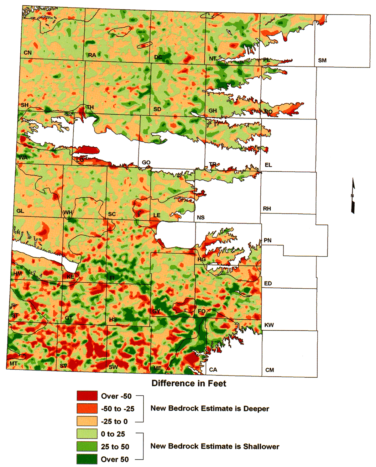
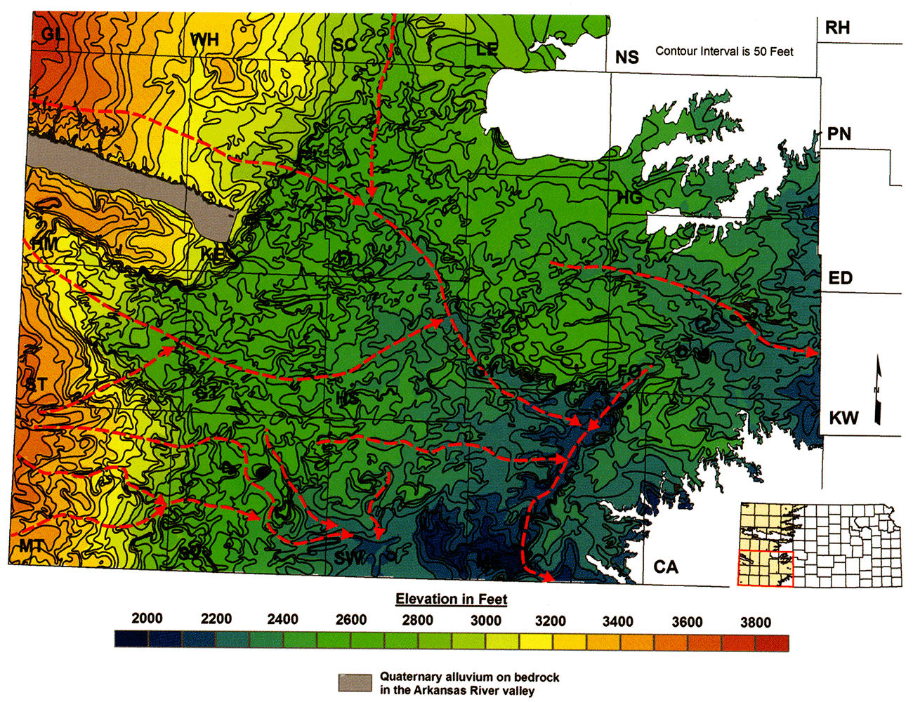
An initial version of the updated bedrock-surface-elevation map is shown in two parts, with fig. 6 showing the map for northwest and west-central Kansas and fig. 7 showing the map for southwest Kansas. The map includes traces of both the Bear Creek and the Crooked Creek-Fowler faults as shown on the 1995 USGS digital-bedrock-surface-elevation map shown in fig. 9. The initial version of the updated map was compared with the 1995 USGS digital map to assess the magnitude of regional and local changes in bedrock elevation and to check for systematic differences between the maps (figs. 8 and 9). Overall, bedrock-surface elevation across the Ogallala region is approximately 1 ft (0.3 m) lower than the 1995 USGS map version, which is well within the error of the data used in creating the updated map (fig. 10). Locally, the magnitude of the change in the configuration of the bedrock surface is greatest in southwest Kansas, and the size of the areas where the change is greatest is larger in this region of the state than elsewhere (fig. 11). A visual comparison of the two map versions clearly shows that the increase in data used to produce the updated map has resulted in a concomitant increase in the level of topographic detail that can be shown. The increase in detail is clearly shown in the nonrandom distribution of bedrock-surface-elevation differences, particularly along an incised paleochannel that trends southeastward across southern Finney, the northeast corner of Haskell, and southwestern Gray counties. Here, the updated bedrock surface is at a higher elevation (is shallower) than on the 1995 USGS map (fig. 9). Elsewhere in southwest Kansas, the updated bedrock surface is lower in elevation (deeper), for example in much of Stevens County.
Figure 6—Northern half of the initial elevation of the bedrock surface beneath the Ogallala aquifer map covering northwest and west-central Kansas.
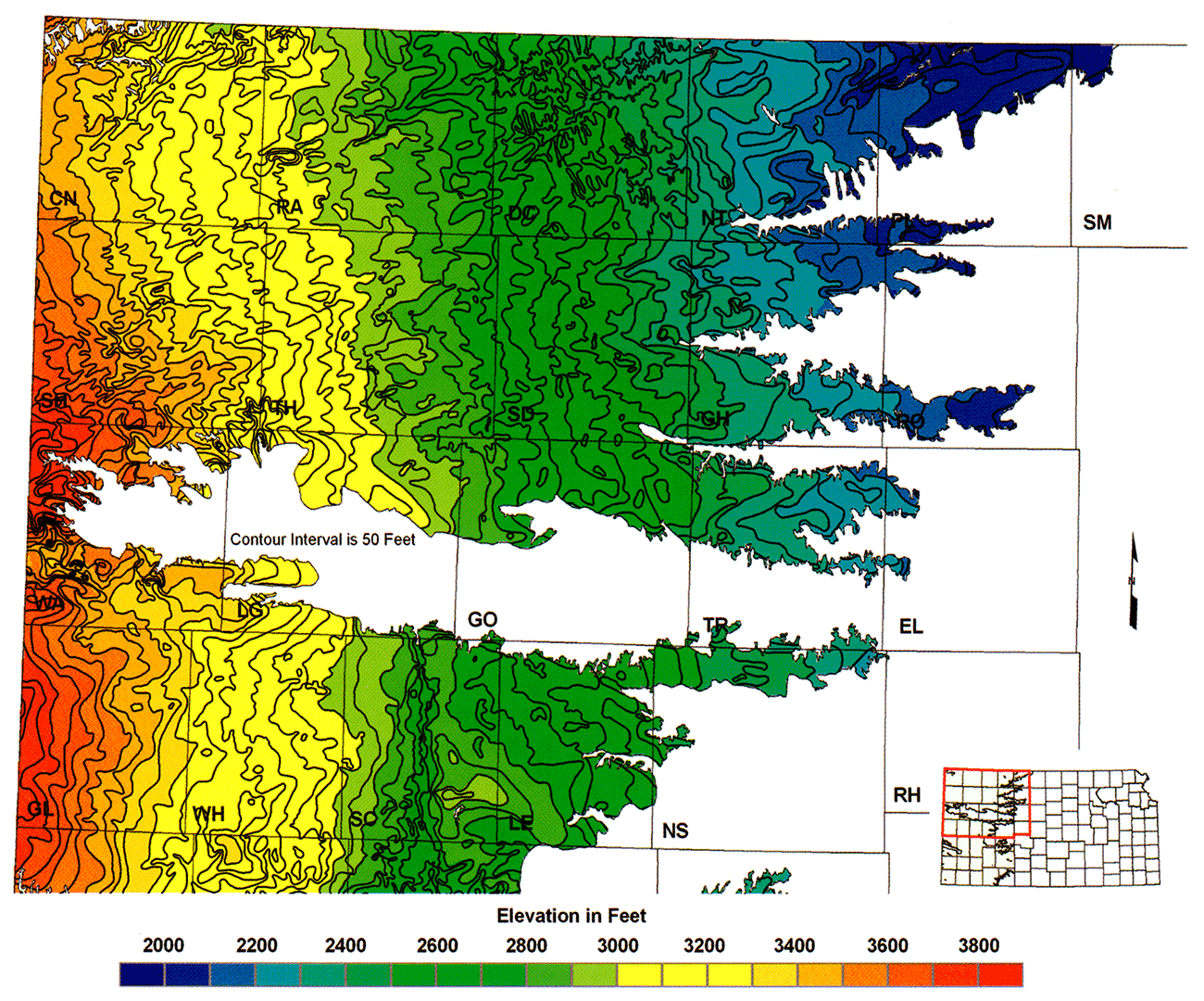
Figure 7—Southern half of the initial elevation of the bedrock surface beneath the Ogallala aquifer map covering southwest Kansas.

Figure 8—Northern half of the 1995 USGS bedrock-surface-elevation map.
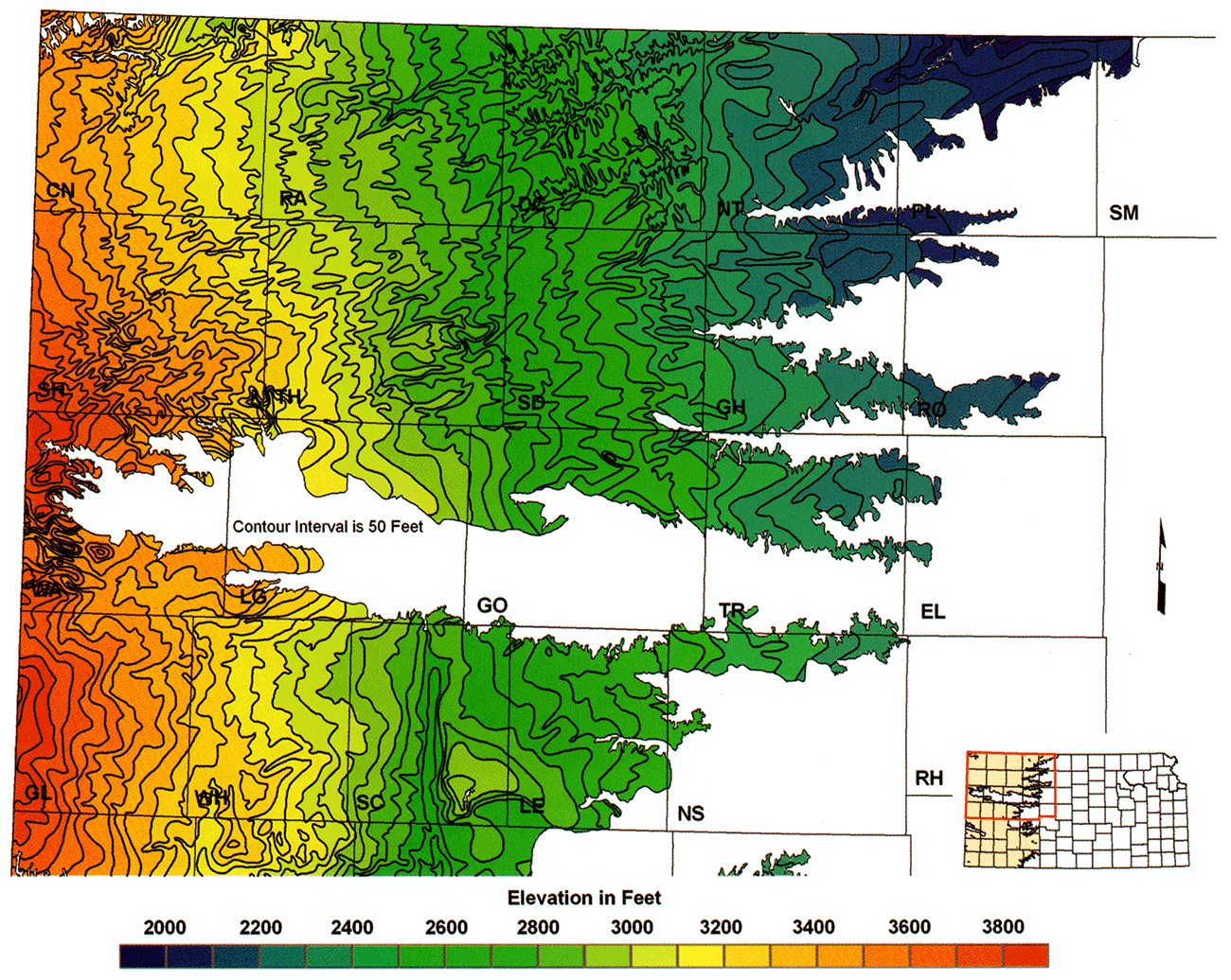
Figure 9—Southern half of the 1995 USGS bedrock-surface-elevation map.
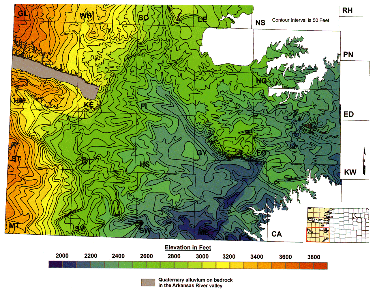
Figure 10—Histogram of the overall elevation differences between the 1995 USGS and the updated elevation of the bedrock surface beneath the Ogallala aquifer maps. The histogram shows an overall downward change in elevation of the bedrock surface of approximately 0.8 ft (0.2 m).
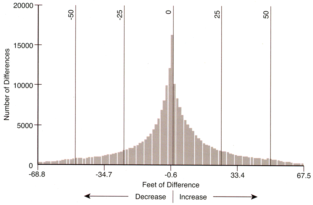
Figure 11—Spatial distribution of elevation differences across the Ogallala region between the 1995 USGS and updated elevation of the bedrock surface beneath the Ogallala aquifer maps. Areas where the bedrock-surface elevation is lower in the updated map than in the 1995 USGS map are shown in red and brown, and areas where it is higher are shown in green.
Since the turn of the 20th century, controversy has existed over the processes responsible for the shallow-subsurface geologic structure in the vicinity of Crooked Creek and the town of Fowler in Meade County. Haworth (1896) advanced the hypothesis that solution of deep-seated evaporites followed by faulting produced the structure that later became known as the Crooked Creek-Fowler fault. However, Johnson (1901) believed that deep-seated solution of evaporites, followed by subsidence of the overlaying strata, was responsible. Smith (1940) indicated that the surface expression of the structure south of Meade was more consistent with faulting of the bedrock and the overlying unconsolidated deposits, but that north of Meade, topography was more consistent with Johnson's subsidence hypothesis. Smith concluded that the controversy could only be resolved by drilling a series of test holes within the structural zone into the bedrock units where evaporite dissolution had taken place. Frye (1941, 1942) reported on the results of an extensive test-hole drilling program across the Meade basin and Crooked Creek. Most of the test holes were drilled into bedrock and down only to the top of the Permian. Test holes were located along three east-west-trending lines extending across Meade County and Crooked Creek and were spaced at distances of approximately 1-6 mi (1.6-9.6 km). On the basis of this drilling and other fieldwork, Frye mapped two, nearly en echelon, north-northeast- to south-southwest-trending, high-angle normal faults and named them the Crooked Creek and the Fowler fault.
Later subsurface mapping of the bedrock surface and the top of the Permian Blaine Formation revealed a northeastward-trending zone of collapse associated with deep-seated salt dissolution across Meade County (Gutentag et al., 1981). The continuity of this zone suggested to Gutentag that the Crooked Creek and Fowler faults were continuous. Spinazola and Dealy (1983) extended the Crooked Creek-Fowler fault northeastward along its trend and then eastward across central Ford County based on an interpretation of the bedrock-surface data and a structure-contour map of the top of the Blaine.
Unlike the controversy over origins of the disturbed zone in Meade County, there has been little controversy over Bear Creek fault. However, there is minimal surface and subsurface evidence to support its existence. In his reconnaissance of the geology of southwest Kansas, Smith (1941) wrote extensively about a northwest-southeast-trending anticline he referred to as the Syracuse flexure, instead of the Syracuse anticline, the name given the structure in Darton (1918). He noted that the structure's southern limb appeared to be steeper than the northern limb and concluded that the structure was post-Ogallala in age. Smith observed the presence of sinkholes along Bear Creek, which he attributed to deep-seated solution of evaporites in the bedrock and stated that some had formed in historic times. He also noted the rectilinear trend of Bear Creek's north branch, which he attributed to faulting. Later, on the basis of a single test hole drilled on the Hamilton-Stanton county line and its location with respect to a nearby outcrop of the Dakota Formation, Latta (1941, p. 25) concluded that significant post-Ogallala faulting had occurred in the Bear Creek valley:
"During the course of the present investigation the Cockrum sandstone [Dakota Formation] was encountered at an altitude of 3,039 feet in a test hole drilled on the Hamilton-Stanton county line. About 1 1/8 miles north of the test well the Cockrum sandstone is exposed at an altitude of 3,350 feet, more than 300 feet higher than in the test hole. It seems unlikely that this much difference in altitude can be attributed to folding and erosion alone; rather, the evidence indicates a normal fault that trends roughly northwest, and dips to the southwest. The Cretaceous strata seem to have been displaced vertically 250 to 300 feet, the downthrown side being the south side."
McLaughlin (1943) cited Latta's (1941) findings as conclusive evidence for the existence of the fault. Jewett (1951) associated the fault with the Syracuse anticline, and Merriam (1963) referred to it as the Syracuse fault. Later, Fader et al. (1964) noted that outcrops of the Dakota Formation occur at the same elevation as those of the Ogallala Formation in T. 30 S., R. 42-43 W., Stanton County, mapped the concealed trace of a fault in the surface geology across the northeast corner of Stanton County and the northwest corner of Grant County, and named the structure the Bear Creek fault. Gutentag et al. (1972) used the elevation of the top of the Day Creek Dolomite to map the concealed fault trace across Kearny County. Gutentag et al. (1981) mapped the concealed trace of the Bear Creek fault in southwest Kansas on their bedrock-surface-elevation map.
Evaporite dissolution is believed to be occurring only in the evaporite-bearing rocks of the Nippewalla Group in southwestern Kansas and not in the underlying Hutchinson Salt Member of the Wellington Formation (Holdoway, 1978; Izett and Honey, 1995). Data compilations of Mudge (1967) and Rascoe and Baars (1972) provide insight into the lithology and depositional environments represented in the Nippewalla Group in the Syracuse and other related depositional basins (figs. 4, 11). Halite and other evaporites accumulated in these restricted basins because of the periodic influx of marine water from the Anadarko basin and high rates of evaporation associated with the prevailing arid conditions (Rascoe and Baars, 1972). Since then, development of oil and gas resources in western Kansas and interest in finding an area suitable for siting a radioactive-waste repository in western Kansas have provided considerable data on the distribution of evaporites within the subsurface Nippewalla Group. Using core samples from an Atomic Energy Commission test hole and geophysical and sample logs, research on the depositional setting, petrology, and geochemistry of the Nippewalla Group in the Syracuse basin of western Kansas and eastern Colorado was conducted and reported in Holdoway (1978).
Significant evaporite thickness is present in the subsurface Blaine, Flower-pot Shale, and Cedar Hills Sandstone formation sequence of the Permian Nippewalla Group in the Syracuse basin and in a smaller region centered on eastern Meade and Clark counties (table 1; Campbell, 1963; Merriam, 1963; Rascoe and Baars, 1972). Within this sequence, Holdoway (1978) found beds of pure halite, fine- to coarse-grained halite associated with anhydrite, and red anhydritic mudstones in a core collected from this sequence in south-central Wichita County near the center of the Syracuse basin. She mapped the Blaine Formation, Flowerpot Shale, and Cedar Hills Sandstone formation thickness in the Syracuse basin and adjacent areas using the available geophysical and cuttings sample logs. Holdoway found that where evaporites dominated the sequence, the unit thickness of the Flower-pot Shale and Blaine Formation was greater than in areas where the units consisted primarily of red beds.
In southern Hamilton, northeastern Stanton, northwestern Grant, and southern Kearny counties, Flower-pot Shale thickness increases rapidly from less than 100 ft (30 m) up to more than 250 ft (76 m) over a map distance of less than 3 mi (4.8 km; Holdoway, 1978). This dramatic increase in Flower-pot Shale thickness along the southern side of the Syracuse basin is nearly coincident with the trace of the Bear Creek fault in the 1995 USGS elevation of the bedrock-surface map, also noted by Holdoway. She attributed the rapid loss of section in the Flower-pot Shale to evaporite dissolution and compaction of the overlying anhydrite-bearing strata.
No recent mapping has been done to delineate the thick evaporite sequences in the upper part of the Permian bedrock in Meade and Clark counties and nearly all of it is based on cuttings samples from oil and gas drilling up through the mid-1960's. Schumaker (1966) summarized previous subsurface work and mapped the extent of the evaporite sequence within the Flowerpot Shale based on cuttings sample logs. Schumaker's map and that of Merriam (1963) for the Nippewalla Group indicate a salt body that underlies all of Clark County, southern portions of Ford and Gray counties, extreme western portions of Kiowa and Comanche counties, eastern and northwestern Meade County, and the northeastern corner of Seward County (fig. 4). Evaporite-sequence thickness is greatest in eastern Meade and Clark counties where it exceeds 350 ft (Schumaker, 1966).
The top of the Blaine Formation was chosen as a structural mapping horizon to evaluate shallow geologic structure in the vicinity of the 1995 USGS mapped Crooked Creek-Fowler and Bear Creek faults in the subsurface resulting from evaporite dissolution. The Blaine top was chosen because it is easily recognized on gamma-ray geophysical logs of boreholes drilled for oil and gas and because depth to the Blaine top from surface is commonly reported by oil- and gas-producing companies. More important, this horizon is situated at the top of the evaporite-bearing sequence within the Nippewalla Group and thus should be sensitive to decreases in thickness of the underlying Blaine Formation and Flower-pot Shale due to evaporite dissolution or faulting.
Data were collected from the records of oil and gas wells available from the KGS web site (http://www.kgs.ku.edu/PRS/petroDB.html), placed in an Excel spreadsheet, and input into ArcGIS. After Blaine top-elevation point data were plotted, contours of equal elevation were drawn using ArcGIS software. Contour maps were produced for the areas around the Crooked Creek-Fowler and Bear Creek fault traces under the assumption that the Blaine top configuration reflects regional structure and local subsidence from underlying evaporite dissolution.
This dissolution-subsidence model of the shallow subsurface was evaluated for each of the two mapped areas by (1) visual inspection of structure maps to determine if a solution-subsidence model is plausible and (2) comparison of the southwest Kansas dissolution zones to the better-characterized central Kansas salt-dissolution zone associated with the Permian Wellington Formation and the Herington Member of the Nolans Limestone.
The Blaine top-structure map in the Crooked Creek area of southern Meade County shows that the top is higher in elevation east of K-23 than it is to the west, contrary to the gentle eastward regional dip of the underlying Stone Corral Formation in this area (figs. 12 and 13). East of the highway, the Blaine top attains an elevation of more than 2,000 ft (610 m) above sea level just north of the Cimarron River and farther north, an elevation of more than 1,950 ft (595 m) south of the town of Meade. In this area, Flower-pot Shale thickness exceeds 200 ft (61 m) due to an evaporite section within the Flower-pot Shale beneath most of Clark and eastern Meade counties (fig. 14; Schumaker, 1966).
Figure 12—Distribution of clastic- and evaporite-dominant lithofacies within the Permian Nippewalla Group in the western part of the Great Plains. Modified from Rascoe and Baars (1972).
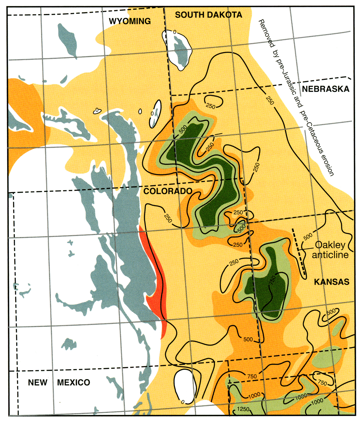
Figure 13—Elevation of the top of the Permian Blaine Formation in a part of southern Meade County in the vicinity of Crooked Creek and the Cimarron River.
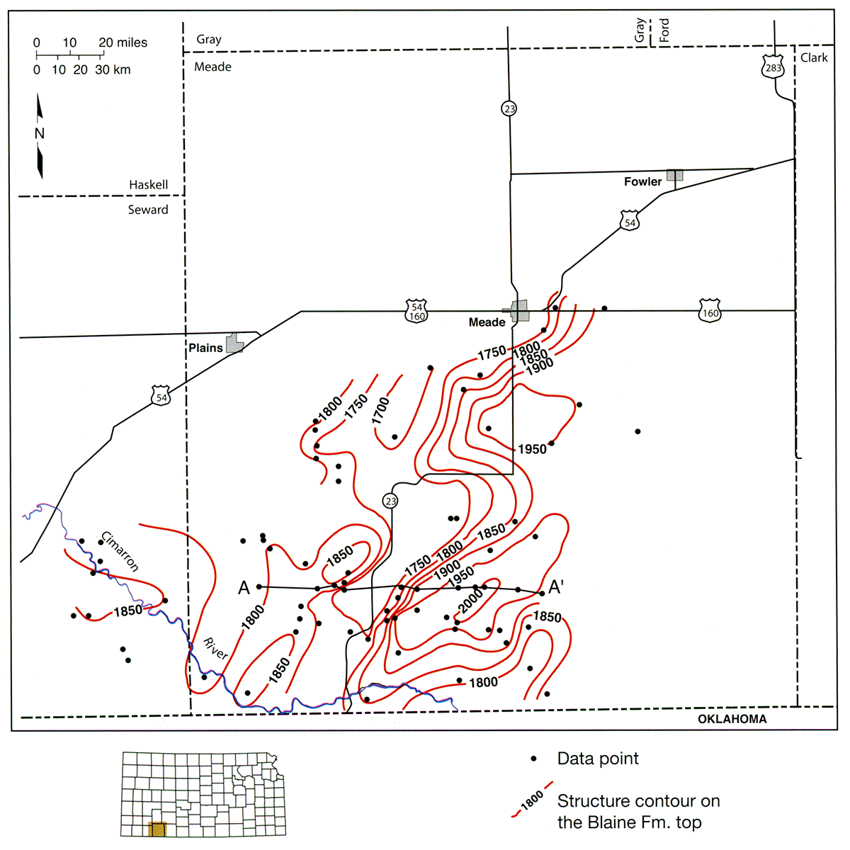
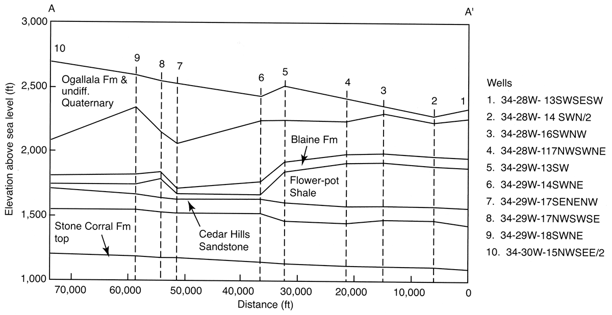
Figure 14—Shallow-subsurface geology along a line of section A-A' in fig. 13 across southern Meade County, Kansas. The cross section shows the change in Flower-pot Shale thickness across the Crooked Creek dissolution zone associated with the loss of the evaporite section.
The close spacing of the Blaine top-elevation contours in the vicinity of K-23 defines the eastern side of an asymmetric structural low where the elevation of the Blaine top is less than 1,750 ft (534 m) in central Meade County and at its lowest point less than 1,700 ft (519 m) southwest of the town of Meade (fig. 13). Maximum dip of the Blaine top is approximately 200 ft (61 m) over a lateral distance of approximately 1 mi (1.6 km) or slightly more than 2° (fig. 13). Where the Blaine top is lowest, Flower-pot Shale thickness is approximately 50 ft (15 m) and the evaporite section is missing (fig. 14).
In southwestern Meade County, two small structural domes, outlined by the 1,850-elevation contour, bound the west side of the structural low. In these areas Flower-pot Shale thickness exceeds 100 ft (30 m) due to evaporites within the unit (figs. 13 and 14).
The structure map shows the Blaine top to be at a higher elevation near the Kansas-Colorado border than in western Finney County, which is consistent with the eastward regional dip of the underlying Stone Corral Formation (figs. 15, 16). The map can be subdivided into two generally distinct areas separated by the arcuate-trace, monoclinal structure. The regional dip on the Blaine is to the northeast. Structural relief from the elevated northern side to the lower southern side of the monocline is on the order of 150 to more than 250 ft (46-76 m) over lateral distances that range from less than a mile to more than 2 mi (3.2 km) or dip angles that range from 3° to <1°. The trace of the monocline closely follows the trend along which thickness of the underlying Flower-pot Shale decreases rapidly by more than 150 ft (46 m; fig. 17).
Figure 15—Elevation of the top of the Blaine Formation in the vicinity of the mapped trace Bear Creek fault on the 1995 USGS map of the elevation of the bedrock surface beneath the Ogallala aquifer in Hamilton, Stanton, Kearny, and Grant counties in southwest Kansas. Mapping based on 8,926 points.
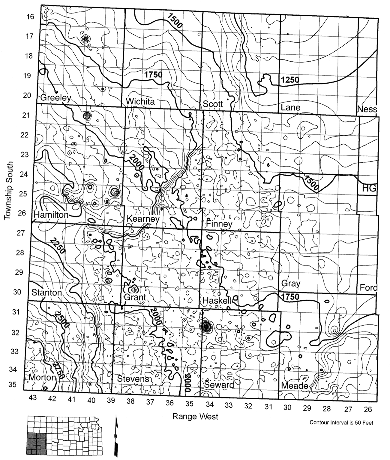
Figure 16—Elevation of the top of the Stone Corral Formation in the vicinity of the Hugoton gas field in southwest Kansas.
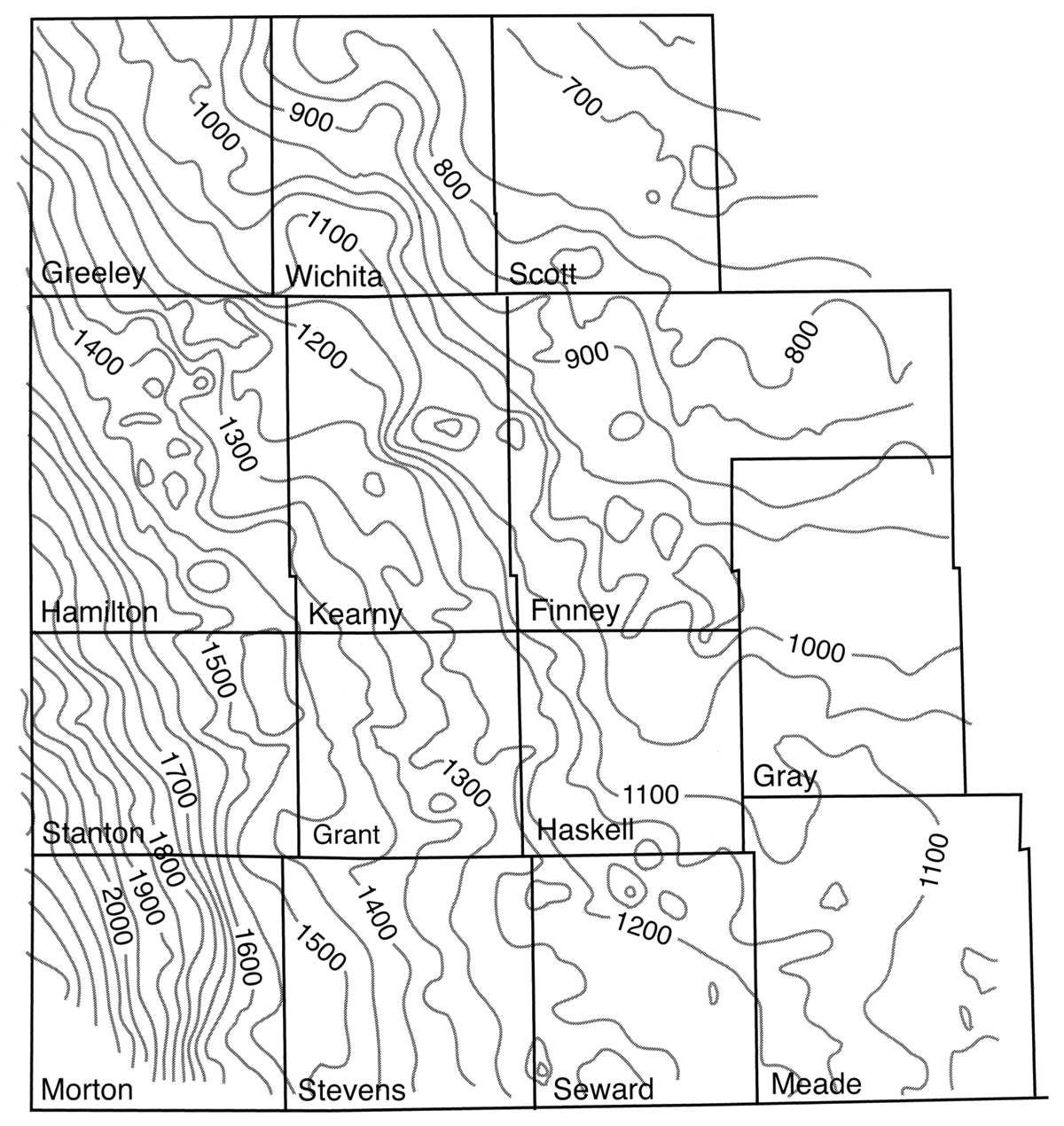
Figure 17—Thickness of the Flower-pot Shale in southwest Kansas (Holdoway, 1978).
With the exception of a few remarks in Holdoway (1978) and in Spinazola and Dealy (1983), little has been published on Permian salt dissolution in southwestern Kansas based on subsurface data. In contrast, research conducted in the central part of the state on evaporite dissolution in the Permian Sumner and uppermost Chase Groups has been considerable and provides an appropriate and relatively well-documented model of a dissolution zone in a hydrogeologic setting similar to that in southwestern Kansas. The following is a summary that has been compiled from work reported in Watney and Paul (1980), Gogel (1981), Gillespie and Hargadine (1981,1986), Sadeghipour et al. (1987), Anderson et al. (1995), and Watney et al. (2003).
Evaporite dissolution has impacted the Lower Permian Herington Limestone Member of the Nolans Limestone, the Wellington Formation, and the Ninnescah Shale and overlying Lower Cretaceous bedrock units and Cenozoic deposits. The Herington consists of dolomitic limestones and thin interbedded tan shales. The limestones tend to be vuggy where dissolution has removed gypsum and other evaporites from the rock (Mazzullo et al., 1997; Macfarlane, 2003). The Wellington consists of a lower unnamed member, the middle Hutchinson Salt Member, and an upper unnamed member. The Hutchinson salt is almost entirely of bedded salt with minor interbedded shales, anhydrite, and gypsum. The upper member of the Wellington and the overlying Ninnescah consist primarily of gray shale and siltstone with minor amounts of gypsum and anhydrite. Lower Cretaceous units consist of shales, siltstones, and sandstones that belong to the Kiowa and Dakota formations. Unconsolidated Tertiary and Quaternary deposits overlie the bedrock surface over much of this part of central Kansas, including the Equus beds, and alluvium and terrace deposits associated with the Smoky Hill, Saline, Solomon, and Arkansas river valleys.
Dip on the bedrock units is westward, and the updip edge of the Hutchinson Salt Member trends from Salina southward through Newton, Wichita, and Wellington.
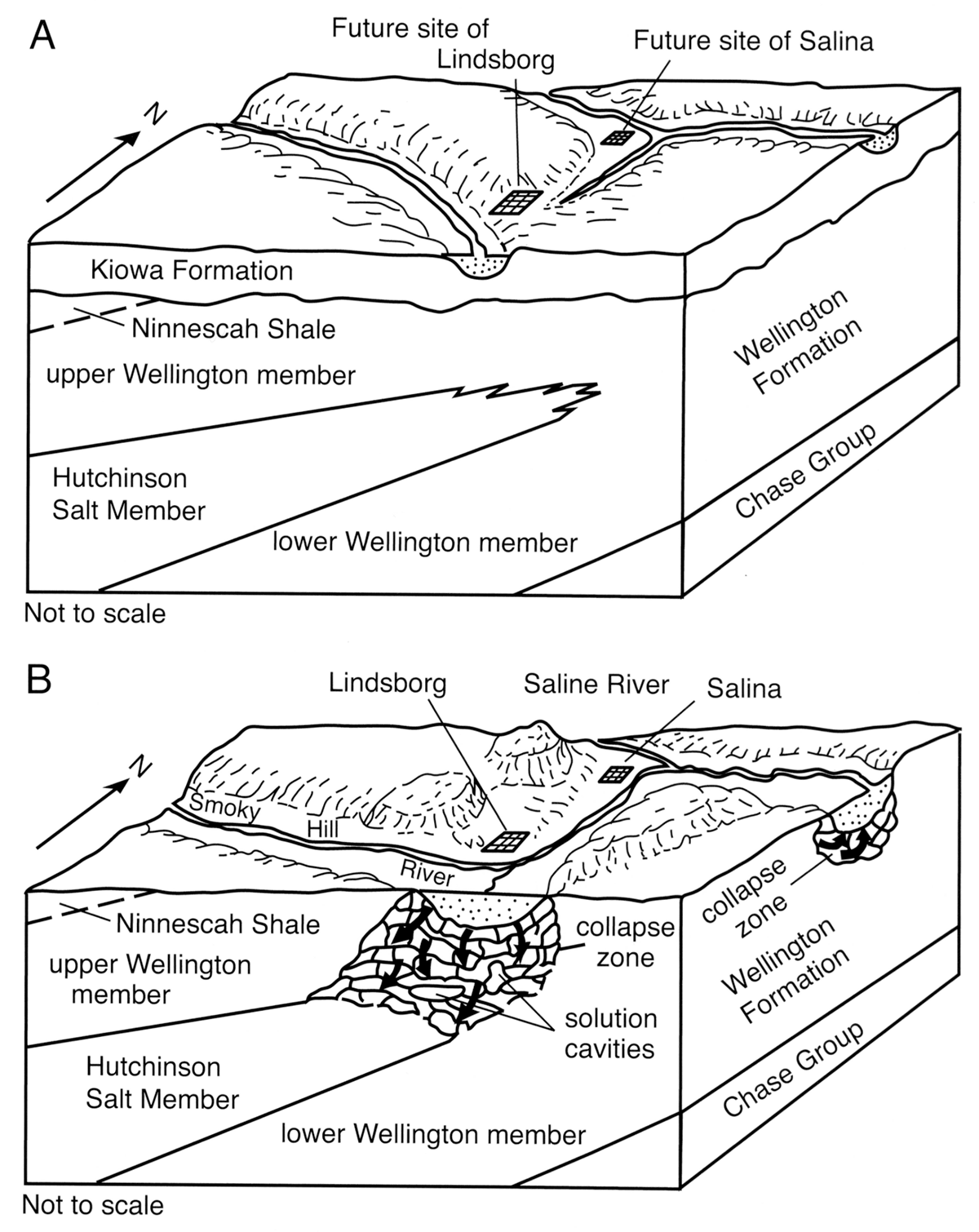
Evolution of the Smoky Hill and the Arkansas drainages is intimately tied to subsidence along the updip edges of the Permian bedrock units due to evaporite dissolution, primarily in the Hutchinson Salt Member of the Wellington Formation (fig. 18). Throughout the Cenozoic, erosion has been actively stripping off the overlying Cretaceous and Permian bedrock units, bringing the updip edge of the evaporite-bearing rocks closer to land surface and within the realm of circulating fresh ground water. Unloading associated with erosion of the overburden changed the stress field and resulted in the development of joint and fracture systems in the Permian shale and siltstone units above the evaporite deposits. These joint and fracture systems facilitated downward flow of ground water across the low-permeability shales and siltstones of the upper Wellington and Ninnescah. Recurrent deep-seated structural movement of basement blocks also may have activated new fractures. Within the shale units, volume expansion associated with the conversion of anhydrite to gypsum also would have opened up new fractures in the shales and siltstones. Thus, the shallow fresh ground-water system began to dissolve the evaporites and initiate subsidence of the overlying strata. Dissolution removed evaporites, causing fracturing of the overlying shale and siltstone units and subsidence of the land surface, all of which helped to localize the river drainage and alluvial deposition along the developing dissolution zone. Consequently, Equus beds sediments now fill a 50-mi (80.5-km)-long trench along a corridor more than 300 mi? (777 km2 ) in extent from McPherson to Wichita created by the dissolution of more than 200 ft (61 m) of halite (Lane and Miller, 1965).
Figure 18—Development of the evaporite dissolution zone at the updip edge of the Hutchinson Salt Member of the Wellington Formation in central Kansas between Cretaceous time (A) and the present (B). Taken from Gogel (1981).
With the drainage localized above the dissolution zone, fracturing and subsidence of overlying shales and siltstones accelerated due to increased flushing by local ground-water-flow systems. In some cases, overlying permeable sand and gravel deposits filled open fractures and solution channels to enhance permeability of the brecciated bedrock. These fracture fillings resulted in a more integrated network of permeable fractures that increased the flow rate of the shallow ground-water system and the intensity of the evaporite dissolution. Increased intensity of dissolution has resulted in coalescence of sinkhole and closed-depression features into subsidence basins and has further enhanced fracture and solution-channel permeability. In comparison, test drilling in the upland areas within and adjacent to the dissolution zone indicates very little evaporite dissolution.
Bear Creek and the Crooked Creek-Fowler dissolution zones and their associated dissolution fronts possess many of the same characteristics and have developed along the same lines as those associated with evaporite dissolution in central Kansas. These similarities suggest that the same geologic processes have been and continue to operate in all three dissolution zones.
In southwest Kansas, undrained depressions, sinkholes, larger-scale subsidence features, and drainage alignment characterize surface topography near the present-day dissolution-front positions. Examples of these smaller-scale features include the Coolidge sink, Jones Ranch sink, Meade salt sink, St. Jacob's well, and sinkholes associated with the Bear Creek drainage and some of the playa features (fig. 4; Merriam, 1963). Izett and Honey (1995) mapped circular depressions of various sizes presumed to be sinkholes and filled with Holocene sediment in the Irish Flats NE 7 1/2-minute quadrangle in Meade County. Some of these features, such as the Meade salt sink and the Coolidge sink, have developed in historic times (Johnson, 1901; Bass, 1931).
At the time of formation, the Meade salt sink was filled not with freshwater but with saline water. Larger-scale features include the Ashland basin, Big Basin, and Little Basin in Clark County (fig. 4), all of which have formed in areas underlain by a thick evaporite sequence in the Flower-pot Shale along or ahead of the main dissolution front. Ashland basin is a coalesced sinkhole approximately 12 mi (19 km) wide and approximately 500 ft (153 m) below the level of the surrounding plains (Schoewe, 1949). Intrusion of saline water upward into the Ogallala from the underlying Permian and eventually into the Cimarron River is an ongoing process (McMahon, 2001).
In central Kansas, the zone of collapsed Permian strata behind the advancing dissolution front is referred to as the Wellington aquifer. At the surface, undrained depressions, sinkholes, and salt seeps and springs characterize this zone. Though not well documented, some of these features have reportedly developed during historic times in central and southwest Kansas.
Lows in the bedrock surfaces near the Bear Creek and Cooked Creek dissolution fronts mimic small- and larger-scale geologic structures in the bedrock as revealed in the Blaine top-elevation map (figs. 13, 15). Behind the dissolution front in southwestern Hamilton and Stanton counties is a 12 to 15-mi (19-24-km)-wide trench in the bedrock surface that overlies a similar structural low in the Blaine top (figs. 15, 19). Within this trench, the bedrock surface is approximately 200 to 250 ft (61-76 m) lower than in surrounding areas to the north and to the south. Similarly, the Blaine top beneath the trench is approximately 200 ft (61 m) lower than in areas to the north and south of this feature. In the vicinity of the Crooked Creek-Fowler dissolution zone, a series of connected lows in the bedrock-surface configuration and structural lows in the bedrock are suggestive of coalesced subsidence basins behind an advancing dissolution front (figs. 13, 20).
Figure 19—Revised elevation of the bedrock-surface map beneath the Ogallala aquifer in portions of Hamilton, Kearny, Grant, Morton, and Stevens and all of Stanton counties in southwest Kansas. To prepare this map, bedrock-surface elevations were contoured assuming dissolution followed by subsidence of the overlying bedrock scenario.
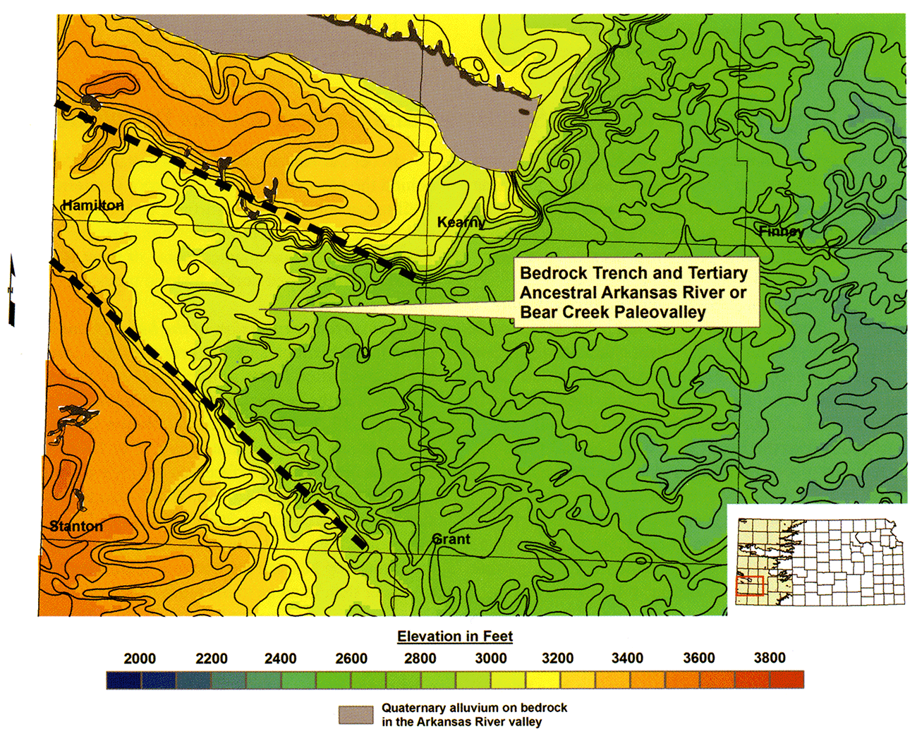
Figure 20—Revised elevation of the bedrock-surface map beneath the Ogallala aquifer in eastern Seward, eastern Finney, Gray, Ford, Meade, and Clark counties in southwest Kansas. To prepare this map, bedrock-surface elevations were contoured assuming dissolution followed by subsidence of the overlying bedrock scenario.
In areas where evaporite dissolution is occurring, the drainage network tends to accelerate the process because of increased circulation of ground water in local flow systems and increased flushing of soluble evaporites from the shallow subsurface.
The present incised Arkansas River valley is located 6 mi to 13 mi (10-21 km) north of the trench and trends west-northwest across Hamilton County in Kansas (fig. 19). The trend of the bedrock low is more northwesterly, and in Colorado the river first crosses the Bear Creek dissolution zone in eastern Prowers County, a few miles west of the Kansas state line. Proximity of the present valley to the trench suggests that this feature may have been previously occupied by an ancestral Arkansas River or alternatively, a paleovalley for an ancestral Bear Creek (Frye and Leonard, 1952). The pronounced mimicking of the bedrock-surface configuration by the shallow-subsurface geologic structure is consistent with a localized drainage flowing through a subsiding valley situated above a dissolution front. Bear Creek drainage is situated above the filled paleovalley and near the current dissolution front. Smith (1941) reported that Bear Creek ceases to be a drainage in southern Kearny County, where its flow is diverted into a basin containing a number of sinkholes near the dissolution front.
Within the Crooked Creek dissolution zone, paleodrainage may have incised a continuous channel in the bedrock surface following the linear trend of these interconnected larger-scale coalesced dissolution features to facilitate movement of surface water from the north southward into Oklahoma (fig. 20). At present, a northeast-trending reach of Crooked Creek is situated in a topographic low that is in close proximity to the dissolution front.
In central Kansas, closed depressions in the bedrock surface beneath the Arkansas and the Smoky Hill alluvial aquifers reflect the coalescence of subsidence basins. The coincidence of lows in the bedrock surface and closed structural depressions in the underlying bedrock suggests subsidence from evaporite dissolution after deposition of the Equus beds and the alluvial fill.
Development of the central Kansas dissolution front has been and continues to be a longterm process that takes place episodically and is controlled by the permeability of the fractured overburden (fig. 18). In some cases there is evidence that fracture permeability is controlled by stresses acting on pre-existing fractures and is generated from subtle episodic movement of deep-seated basement structures.
The present dissolution front along the edge of the Hutchinson Salt Member is somewhat irregular, and the salt abruptly thickens downdip and is not defined by a mappable single fault or system of faults. Data from high-resolution 2D seismic-reflection surveys taken on the west side of the city of Hutchinson show that local faulting at the top of the Hutchinson salt is correlated with a dissolution reentrant ahead of the main front. Seismic data and other high-resolution subsurface mapping indicate that the fractures are related to regional deep-seated structures. Fault displacements are in the 10-20-ft (3-6-m) range (Watney et al., 2003).
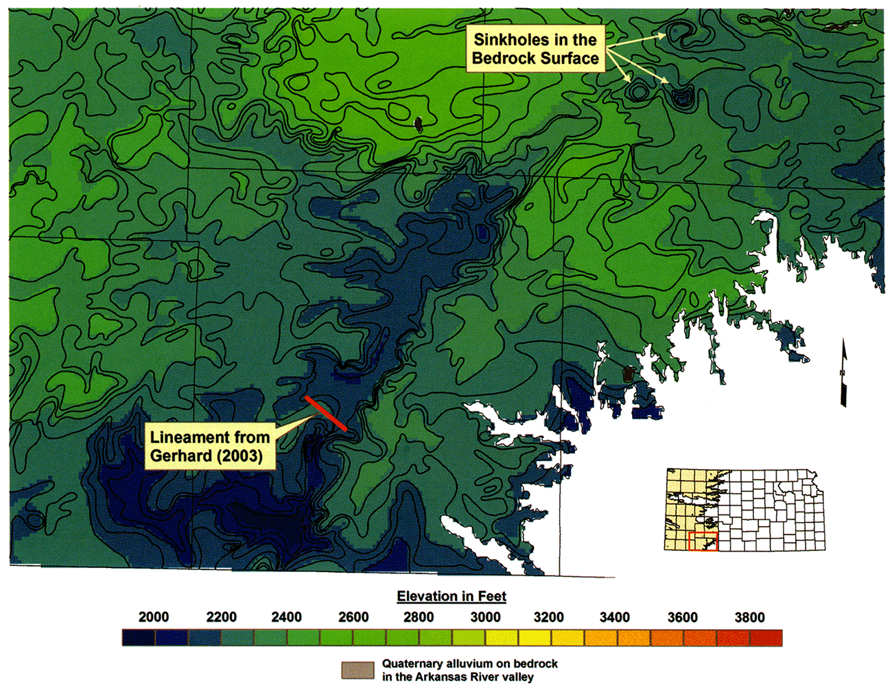
In southwest Kansas, the trend of each dissolution front is parallel to or coincident with regional lineaments identified in the Gerhard (2004) lineament map, suggesting deep-seated fracture control (fig. 21). A long northeast-trending dissolution front in Kearny County is coincident or nearly so with a northeast-trending lineament that extends across southeastern Kearny County. The northwest trend of the dissolution front in southwestern Hamilton and northern Stanton counties is parallel to the northwest trend of other western Kansas regional lineaments.
Figure 21—Cole's (1976) map of the elevation of the top of the Precambrian in Kansas.
The trace of the dissolution front in the Crooked Creek vicinity can only be generally defined on the Blaine top-elevation map due to the limited subsurface data. Thus, the Crooked Creek front is more broadly defined than the Bear Creek front. However, it is apparent that reentrants have formed where dissolution has or is taking place ahead of the front. A northwest- to southeast-trending reentrant in the salt-dissolution front and an overlying low in the bedrock surface are coincident with a short northwest-to-southeast lineament (figs. 20, 21). The northeast trend of the Crooked Creek-Fowler dissolution front is parallel to the northeast-trending segment of the Bear Creek dissolution zone (figs. 19, 20). Izett and Honey (1995) mapped a few small faults with less than 2 ft (0.6 m) of vertical displacement in Pliocene deposits in southern Meade County. To the south near the state line with Oklahoma, coincident northward-trending lows in the bedrock surface and in the Blaine top-structure map are subparallel to northeast-trending lineaments (figs. 20, 21) in the area, which suggests salt dissolution controlled by fractures.
The apparent low-dip angles on the top of the Blaine across the Bear Creek and Crooked Creek structures neither confirms nor denies the solution-subsidence or the solution-faulting model. To obtain such confirmation would require continuous data across the structures, such as from seismic reflection or at the minimum, very closely spaced test holes. Nevertheless, the absence of apparent high-dip angles or an obvious discontinuity on the Blaine top across these structures lends some support to the solution-subsidence interpretation.
The strong similarity of the southwest Kansas dissolution zones to the dissolution zone in central Kansas strongly suggests that the dissolution front is not characterized by a single fault or network of faults. Rather, evaporite dissolution occurs sporadically and nonuniformly along a front over long periods of time facilitated locally by shallow fractures resulting from reactivation of deep-seated fracture systems. The Blaine top-structure map reveals small closed lows in advance of the main dissolution front. Behind the dissolution front, deep lows in the bedrock surface and in the underlying structure can be found near the Bear Creek and the Crooked Creek dissolution zones. At the surface, sinkholes and other subsidence features, some actively developing, also occur in advance of the main front.
Based on this evaluation, the bedrock surface in the southern half of the updated bedrock map was recontoured assuming that the bedrock lows have resulted primarily from subsidence following evaporite dissolution (fig. 22). The northern part of the Crooked Creek-Fowler fault was not evaluated with the same methodology that was used to evaluate the southern part of the structure in Meade County. We believe that Spinazola and Dealy (1983) incorrectly correlated the Dakota Formation-Ogallala contact across the structure and thus interpreted a fault offset across the supposed fault trace. This extension of the fault into Ford County does not appear on the 1995 USGS map. The revised bedrock-surface configuration shows that a series of deep sinkhole features have developed in the Cretaceous bedrock where a significant evaporite thickness is present within the Nippewalla Group ahead of the dissolution front in southern Ford County (fig. 20).
Figure 22—Revised southern half of the elevation of the bedrock-surface map beneath the Ogallala aquifer.

Regional slope on the bedrock surface beneath the Ogallala in northwest, west-central, and southwest Kansas is northeasterly at 9.8 ft/mi (1.8 m/km), easterly at 13.8 ft/mi (2.6 m/km), and easterly at 9.5 ft/mi (1.8 m/km), respectively (figs. 6 and 22). In comparison, the average land-surface slope is eastward at a rate of 12.9 ft/mi (2.4 m/km) in west-central Kansas. In southwest Kansas, the average land surface slope is 15 ft/mi (2.8 m/km) west of the Scott-Finney depression and about 15 ft/mi (2.8 m/km) to the east (Smith, 1941).
Local relief on the bedrock surface in part depends on the subsurface geology and on the amount of incision into the bedrock by streams (figs. 6 and 22). In southwestern Kansas, local relief exceeds 200 ft/mi (38 m/km) where (1) bedrock escarpments occur, such as in southwestern Gray County; (2) remnant hills of bedrock resistant to erosion exist, such as in Stevens, western Rawlins, and eastern Sherman, Thomas, and Sheridan counties; (3) Permian evaporite dissolution is ongoing, such as in Meade or in southwestern Hamilton and Stanton counties; or (4) local subsidence has occurred in the immediate vicinity of sinkholes.
The significant geologic events that affected the central Great Plains bedrock surface beneath the Ogallala aquifer since Cretaceous deposition include the following (Merriam, 1963; Frye, 1970; Trimble, 1980; Gable and Hatton, 1983; Shaw, 1987; Baars et al., 1988; Dickinson et al., 1988; Osterkamp et al., 1987):
Ogallala sediments were deposited in a wide band that extended from near the Front Range in central Colorado eastward to the Flint Hills in Kansas by streams flowing from sources in the mountains to the west (Smith, 1941; Merriam and Frye, 1954; Frye et al., 1956; Frye, 1970; Pearl, 1971; Trimble, 1980). Deposition initially took place in pre-existing valley systems and eventually overtopped stream divides. Some time later, deposition waned and ceased altogether, and stream downcutting ensued in response to Pliocene differential uplift of the southern and central Rocky Mountains and the Great Plains. Tectonic uplift of the Plains initiated downcutting and erosion by an ancestral Arkansas and Platte River system, which was more intense nearer the mountain front than in areas to the east (Trimble, 1980; Tainter, 1987) and resulted in an erosion-induced isostatic adjustment that increased the total magnitude of uplift (McMillan et al., 2002; Leonard, 2002). By early Quaternary (Nebraskan time), the Arkansas River had established a course across southeastern Colorado and southwestern Kansas (Frye and Leonard, 1952; Soister, 1967; Sharps, 1969).
Quaternary stream entrenchment in the nonglaciated central Great Plains resulted from climatically induced EDS cycles (Osterkamp et al., 1987) and indirectly from continuing differential uplift of the Great Plains near the Rocky Mountain front (Trimble, 1980; McMillan et al., 2002). In southeastern Colorado, the Arkansas River eroded below the High Plains surface by more than 1,475 ft (450 m) along the mountain front and approximately 575 ft (175 m) near the Kansas-Colorado border leaving a series of Pliocene and Quaternary terraces that are graded to former river levels (Sharps, 1969; Leonard, 2002). This pattern of progressively younger graded terrace levels with decreasing elevation in the basin is repeated for other drainages farther east in the Smoky Hill and Saline River drainages in Kansas (Frye, 1945; Leonard and Berry, 1961). Drainage capture and the downstream effects of glaciation also have played a significant role in the evolution of the drainages in the Kansas River basin (Bayne and Fent, 1963).
Bedrock-surface configuration beneath the Ogallala in western Kansas apparently reveals two major paleodrainage basins separated by an east- to west-trending bedrock high coincident with the present Smoky Hill River near the Colorado border in northwest Wallace County (figs. 6, 22). North of the Smoky Hill River, only Ogallala sediments overlie the bedrock surface (Frye et al., 1956). Thus, bedrock-surface configuration shows pre-Ogallala paleodrainage to be southwest to northeast following the slope of the bedrock surface and parallel to or coincident with the modern drainage. The reconstructed major Pleistocene paleodrainages of Frye and Leonard (1952) and Pearl (1971) indicate post-Ogallala headward extension of drainages from the east into northwest Kansas and eastern Colorado, followed by integration into the present drainage pattern through stream capture. Merriam (1963), Fader et al. (1964), and Pearl (1971) promoted the belief that most of the early Quaternary drainage was nearly coincident with the pre-Ogallala drainage.
South of the Smoky Hill River, the bedrock surface is overlain by Ogallala sediments over most of the region and elsewhere by Quaternary or undifferentiated Cenozoic sediments. The presence of sediments of differing age indicates that bedrock surface age is not pre-Ogallala everywhere but rather has been sculpted by both pre- and post-Ogallala erosional episodes (Frye, 1942; Merriam, 1963; Fader et al., 1964). Impacts of Permian evaporite dissolution and subsidence on drainage development also have served to focus pre- and post-Ogallala erosion episodes and sediment deposition in subsidence areas along pre-existing fracture systems.
In southern Kansas, the bedrock-surface map generally shows that the pre-Ogallala drainage was from west-central Kansas and southeastern Colorado southward into Oklahoma (fig. 23). Closer inspection reveals an east-west-trending drainage divide across northern Morton, Stevens, and western Seward counties. A southern drainage entered Kansas from southeastern Baca County, Colorado, and a northern drainage entered the state from Prowers County, Colorado, via the ancestral Bear Creek or Arkansas River paleovalley. The southern drainage seems to end in a series of bedrock lows in southern Seward County that may have been sites for one or more paleolakes. Frye (1942) described surface exposures of freshwater limestone nearby in Meade County in the lower part of the Pliocene Laverne formation, just above the Permian bedrock surface.
Figure 23—Major paleodrainages incised into underlying Cretaceous through Permian bedrock in southwest Kansas shown as red dashed lines with an arrow superimposed on the elevation of the bedrock-surface map. On the basis of the age of the overlying Cenozoic deposits, some of these paleovalley systems existed prior to Ogallala deposition, and some are younger.
Portions of the northern paleodrainage may have existed prior to Ogallala deposition and during the early Pleistocene (Waite, 1947; Frye and Leonard, 1952). The west end of the northwest-trending Bear Creek dissolution zone crosses the Arkansas River a few miles west of the Kansas-Colorado border, and in Kansas the bedrock surface is covered by Ogallala sediments, which are overlain by Quaternary deposits (Fader et al., 1964). Intersection of the dissolution zone with the Arkansas River valley in Colorado suggests that perhaps a reach of the ancestral Arkansas River or an ancestral tributary may have followed the low in the bedrock surface created by evaporite dissolution prior to Ogallala deposition. Frye and Leonard (1952) also suggested that the bedrock low above the dissolution zone could have been a Nebraskan drainage. Alternatively, the bedrock low could have been the paleovalley for an ancestral Bear Creek. A reach of the present day North Bear Creek follows the trend of this paleovalley before ending near the dissolution front.
In southeastern Colorado, Sharps (1969) used the distribution of the high-terrace gravels in southeastern Colorado from Fowler to the Kansas state line to map the lateral migrations of the Arkansas River through the Quaternary. The Nebraskan-age Arkansas River crossed the Kansas state line in T. 22 S., approximately 7 mi (11 km) north of the present channel where it crosses the state line. In northern Hamilton County, a broad low in the bedrock surface just west of the Scott-Finney depression in T. 22 S., R. 36 W.; T. 23 S., R. 37 W.; and T. 24 S., R. 37 W., may be an expression of the ancestral Arkansas River valley that existed during the early Quaternary (fig. 19, 23).
The bedrock-surface-configuration map shows a major tributary that joined the ancestral Arkansas River from the north following the north-south axis of the Scott-Finney depression in T. 25 S., R. 33 W., southern Finney County (fig. 23). Both Ogallala and Quaternary sediments directly overlie the bedrock surface within the depression (Waite, 1947). From a juncture in southern Finney County, the paleodrainage trends southeastward along the foot of the Greenhorn escarpment across southern Finney, the northeastern corner of Haskell, southwestern Gray, and northern Meade counties. In northern Meade County, the bedrock-surface-configuration map reveals a northeast- to southwest-trending deep elongate bedrock low atop the Crooked Creek dissolution zone (figs. 19,n23). This elongate bedrock low may have been the paleovalley for another reach of the ancestral Arkansas River. Frye and Leonard (1952) believed this part of the drainage existed during Nebraskan and Kansan time. However, Frye (1942) reported Pliocene Laverne and Ogallala sediments resting on the Permian bedrock surface in this paleovalley. Occurrence of both Pliocene and Quaternary sediment fills suggests that the paleovalley also existed prior to Ogallala deposition.
If the bedrock trench associated with the Bear Creek dissolution zone was carved by an ancestral Arkansas River, it is tempting to speculate as to what caused the somewhat dramatic northward shift in the pre-Ogallala drainage from its position south to a position north of the present-day Arkansas River valley during the glacial period (pre-Illinoian). One possible explanation is differential uplift of the Colorado piedmont. During the late Eocene and later during the Pliocene, differential uplift most likely accompanied shallow emplacement of a basalt intrusion at Two Buttes and the Pliocene eruption of basalt flows in southeastern Colorado and northeastern New Mexico (McLaughlin, 1954; Davis et al., 1996; Stroud, 1997). Igneous intrusive activity and volcanism would have caused an upward doming of the overlying strata resulting in local differential uplift. The extruded volcanic flows most certainly increased the elevation of the land surface where they were deposited.
In southeastern Colorado, Mesa de Maya rises more than 300 ft (91 m) above the surrounding plains. The mesa is capped by a basaltic flow, which overlies the Ogallala Formation. The increased elevation of the land surface from doming and flow deposition would have increased surface gradients and the erosive power of streams tributary to both the Arkansas and Cimarron rivers. In the case of the Arkansas, increased erosive power of the streams might have brought more sediment into the river valley where it would most likely have been deposited in an alluvial fan (Sharps, 1969). This might have contributed to the northward migration of the Arkansas River to a new course to maintain its profile across the Colorado piedmont into Kansas.
Northward of these more through-going paleodrainages, an apparent bedrock paleovalley occurs a few miles south of and sub-parallel to the present Arkansas River across northern Gray County and east-southeast across Ford County (fig. 22). The paleovalley is incised into Upper Cretaceous bedrock units. Waite (1942) considered the mapped deposits that fill this valley as Ogallala, but Frye and Leonard (1952) assigned them to the Quaternary.
A bedrock-surface-elevation map is essential to making assessments of ground-water availability in the Ogallala portion of the High Plains aquifer in Kansas. The updated map (Plate 1A and 1B, envelope) shows the relief of the bedrock surface in much greater detail than the 1995 USGS digital map. Consequently, the improved map will provide State water agencies and Groundwater Management districts with a more accurate assessment of saturated thickness than is currently defined for this aquifer system. This ability to make a more detailed assessment is a critical first step in the process of formulating subaquifer units and their respective tailored management plans. Because the map is digital and a documented digital database was used to develop it, future improvements can be made easily by adding to the existing database and adjusting the contouring where warranted. Periodic updating of the map would further enhance the currency of saturated-thickness determinations.
The updated map also provides new data to evaluate old and to formulate new ideas concerning the geology of western Kansas. In the course of updating the bedrock map, an evaluation of the Crooked Creek and Bear Creek fault zones was conducted to determine if the continuous-fault hypothesis of Haworth (1897) and Latta (1941) or the dissolution-zone hypothesis of Johnson (1901) provided a more likely explanation for the observed subsurface and surface geology. Based on a comparison of these zones with the research that has been done on the natural dissolution of the Permian Hutchinson Salt Member and the subsequent subsidence of the overlying units, Johnson's dissolution-zone explanation is a better fit to the observed geology than the continuous-fault interpretation. Consequently, the traces that were referred to as the Crooked Creek-Fowler and Bear Creek faults have been removed, and adjustments have been made to account for the dissolution-zone hypothesis. The updated map also provides a more detailed delineation of pre-Ogallala paleovalley systems and thus more insight into the Cenozoic drainage development of western Kansas in response to uplift of the Rocky Mountains to the west and to climate.
Anderson, N. L., Knapp, R. W., Steeples, D. W., and Miller, R. D., 1995, Plastic deformation and dissolution of the Hutchinson Salt Member in Kansas; in, Geophysical Atlas of Selected Oil and Gas Fields in Kansas, N. L. Anderson, ed.: Kansas Geological Survey, Bulletin 237, p. 66-70. [available online]
Baars, D. L., Bartleson, B. L., Chapin, C. E., Curtis, B. F., De Voto, R. H., Everett, J. R., Johnson, R. C., Molenaar, C. M., Peterson, F., Schenk, C. J., Love, J. D., Merin, I. S., Rose, P. R., Ryder, R. T., Waechter, N. B., and Woodward, L. A., 1988, Basins of the Rocky Mountain region; in, Sedimentary Cover-North American Craton, L. L. Sloss, ed.: The Geology of North America, Geological Society of America, D-2, p. 109-220.
Bass, N., 1931, Recent subsidence in Hamilton County, Kansas: American Association of Petroleum Geologists, Bulletin 15, p. 201-205.
Bayne, C. K., ed., 1976, Stratigraphy and faunal sequence, Meade County, Kansas: Kansas Geological Survey, Guidebook Series 1, 85 p. [available online]
Bayne, C. K., and Fent, O. S., 1963, The drainage history of the upper Kansas River basin: Transactions of the Kansas Academy of Science, v. 66, no. 3, p. 363-377.
Camp Dresser and McKee, Inc., 1979, Interim report, six-state High Plains-Ogallala aquifer area study: Kansas Water Office for the U.S. Department of Commerce, 142 p.
Camp Dresser and McKee, Inc., Black and Veatch, and A. D. Little, Inc., 1982, Six-state High Plains-Ogallala aquifer regional resources study-summary: Kansas Water Office for the U.S. Department of Commerce.
Campbell, C. L., 1963, Upper Permian evaporites of western Kansas between the Blaine Formation and Stone Corral Formation: M.S. thesis, University of Kansas, 73 p.
Cole, V. B., 1976, Configuration of the top of the Precambrian rocks in Kansas: Kansas Geological Survey, Map Series M-7, 1 sheet. [available online]
Darton, N. H., 1918, The structure of parts of the Great Plains; in, Contributions to Economic Geology, 1918, Part II, Mineral Fuels, D. White G. H. Ashley, and M. R. Campbell: U.S. Geological Survey, Bulletin 691-A, p. 1-26. [available online]
Davis, L. L., Smith, D., McDowell, F. W., Walker, N. W., and Borg, L. E., 1996, Eocene potassic magmatism at Two Buttes, Colorado, with implications for Cenozoic tectonics and magma generation in the western United States: Geological Society of America, Bulletin, v. 108, no. 12, p. 1,567-1,579.
Dickinson, W. R., Klute, M. A., Hayes, M. J., Janecke, S. U., Lundin, E. R., McKittrick, M. A., and Olivares, M. D., 1988, Paleogeographic and paleotectonic setting of Laramide sedimentary basins in the central Rocky Mountain region: Geological Society of America, Bulletin, v. 100, p. 1,023-1,039.
Fader, S. W., Gutentag, E. D., Lobmeyer, D. H., and Meyer, W. R., 1964, Geohydrology of Grant and Stanton counties, Kansas: Kansas Geological Survey, Bulletin 168, 147 p. [available online]
Frye, J. C., 1942, Geology and ground-water resources of Meade County, Kansas: Kansas Geological Survey, Bulletin 45, 152 p. [available online]
Frye, J. C., 1945, Valley erosion since Pliocene "algal limestone" deposition in central Kansas: Kansas Geological Survey, Bulletin 60, part 3, p. 85-100. [available online]
Frye, J. C., 1970, The Ogallala Formation a review: Proceedings of the Ogallala Aquifer Symposium, Texas Tech University, Lubbock, 242 p.
Frye, J. C., and Leonard, A. B., 1952, Pleistocene geology of the Kansas: Kansas Geological Survey, Bulletin 99, 230 p. [available online]
Frye, J. C., Leonard, A. B, and Swineford, A., 1956, Stratigraphy of the Ogallala Formation (Neogene) of northern Kansas: Kansas Geological Survey, Bulletin 118, 92 p. [available online]
Gable, D. J., and Hatton, T., 1983, Maps of vertical crustal movements in the conterminous United States over the last 10 million years: U.S. Geological Survey, Miscellaneous Investigations Series Map I-1315, 2 sheets. [available online]
Gerhard, L. C., 2004, A new look at an old petroleum province; in, Current Research in Earth Sciences: Kansas Geological Survey, Bulletin 250, part 1 [available online]
Gillespie, J. B., and Hargadine, G. D., 1981, Saline ground-water discharge to the Smoky Hill River between Salina and Abilene, central Kansas: U.S. Geological Survey, Water Resources Investigations 81-43, 71 p. [available online]
Gillespie, J. B., and Hargadine, G. D., 1986, Geohydrology of the Wellington alluvial aquifer system and evaluation of possible locations for relief wells to decrease saline ground-water discharge to the Smoky Hill and Solomon rivers, central Kansas: U.S. Geological Survey, Water Resources Investigations 86-4110, 31 p. [available online]
Gogel, T., 1981, Discharge of saltwater from Permian rocks to major stream-aquifer systems in central Kansas: Kansas Geological Survey, Chemical Quality Series 9, 60 p. [available online]
Gutentag, E. D., Lobmeyer, D. H., McGovern, H. E., and Long, W. A., 1972, Ground water in Kearny County, Kansas: U.S. Geological Survey, Hydrologic Atlas HA-416, 2 sheets. [available online]
Gutentag, E. D., Lobmeyer, D. H., and Slagle, S. E., 1981, Geohydrology of southwestern Kansas: Kansas Geological Survey, Irrigation Series 7, 73 p. [available online]
Hansen, Christi, and Juracek, Kyle, 1995, High Plains aquifer, altitude of the base of the High Plains aquifer in Kansas: U.S. Geological Survey, distributed from the Kansas Geospatial Community Commons (KGCC) of the Kansas GIS Policy Board and the Data Access & Support Center (DASC) at http://www.kansasgis.org
Haworth, E., 1896, Local deformation strata in Meade County, Kansas, and adjoining territory (preliminary): American Journal of Science, ser. 4, v. 2, p. 368-373.
Hibbard, C. W., 1953, The insectivores of the Rexroad fauna, upper Pliocene of Kansas: Journal of Paleontology, v. 27, no. 1, p. 21-32.
Hibbard, C. W., 1958, New stratigraphic names for early Pleistocene deposits in southwestern Kansas: American Joumal of Science, v. 256, no. I, p.54-59.
Hibbard, C. W., and Taylor, D. W., 1960, Two late Pleistocene faunas from southwestern Kansas: Michigan University Museum of Paleontology Contribution, v. 16, no. 1,223 p.
Holdoway, K., 1978, Deposition of evaporites and red beds of the Nippewalla Group, Permian, western Kansas: Kansas Geological Survey, Bulletin 215, 43 p. [available online]
Izett, G. A., and Honey, J. G., 1995, Geologic map of the Irish Flats NE quadrangle, Meade County, Kansas: U.S. Geological Survey, Miscellaneous Investigation Series Map I-2498, 1:24,000, 1 sheet. [available online]
Jewett, J. M., 1951, Geologic structures in Kansas: Kansas Geological Survey, Bulletin 90, pt. 6, p. 105-172. [available online]
Johnson, W. D., 1901, The High Plains and their utilization: U.S. Geological Survey, 21st Annual Report, part 4, p. 609-741. [available online]
Lane, C. W., and Miller, D. E., 1965, Geohydrology of Sedgwick County, Kansas: Kansas Geological Survey, Bulletin 176, 100 p. [available online]
Latta, B. F., 1941, Geology and ground-water resources of Stanton County, Kansas: Kansas Geological Survey, Bulletin 37, 119 p. [available online]
Latta, B. F., 1944, Geology and ground-water resources of Finney and Gray counties, Kansas: Kansas Geological Survey, Bulletin 55, 272 p. [available online]
Leonard, A. R, and Berry, D. W., 1961, Geology and ground-water resources of southern Ellis County and parts of Trego and Rush counties, Kansas: Kansas Geological Survey, Bulletin 149, 156 p. [available online]
Leonard, E. M., 2002, Geomorphic and tectonic forcing of late Cenozoic warping of the Colorado piedmont: Geology, v. 30, no. 7, p. 595- 598.
Macfarlane, P. A., 2003, The hydrogeology of Crystal Spring with and delineation of its source water assessment area: Kansas Geological Survey, Open-file Report 2003-35, 156 p. [available online]
Macfarlane, P. A., Combes, J., Turbek, S., and Kirshen, D., 1993, Shallow subsurface bedrock geology and hydrostratigraphy of southwestern Kansas: Kansas Geological Survey, Open-file Report 93-1a, 13 p., 18 maps, 1 :500,000 scale. [available online]
Mazzullo, S. J., Teal, C. S, and Burtnett, C. A., 1997, Outcrop stratigraphy and depositional facies of the Chase Group (Permian, Wolfcampian) in Kansas and southeastern Nebraska: Kansas Geological Survey, Technical Series 6, 210 p.
McKee, E. D., Oriel, S. S., et al., 1967, Paleotectonic investigations of the Permian System of the United States: U.S. Geological Survey, Professional Paper 515, 271 p. [available online]
McLaughlin, T. G., 1943, Geology and ground-water resources of Hamilton and Keamy counties, Kansas: Kansas Geological Survey, Bulletin 49, 220 p. [available online]
McLaughlin, T. G., 1954, Geology and ground-water resources of Baca County, Colorado: U.S. Geological Survey, Water Supply Paper 1256, 232 p. [available online]
McMahon, P. B., 2003, Vertical gradients in water chemistry in the central High Plains aquifer, southwestern Kansas and Oklahoma panhandle, 1999: U.S. Geological Survey, Water Resources Investigations Report 2001-4028,47 p. [available online]
McMillan, M. E., Angevine, C. L., and Heller, P. L., 2002, Postdepositional tilt of the Miocene-Pliocene Ogallala Group on the westem Great Plains-evidence of late Cenozoic uplift of the Rocky Mountains: Geology, v. 30, no. 1, p. 63-66.
Merriam, D. F., 1963, The geologic history of Kansas: Kansas Geological Survey, Bulletin 162, 317 p. [available online]
Merriam, D. F., and Frye, J. C., 1954, Additional studies of the Cenozoic of western Kansas: Kansas Geological Survey, Bulletin 109, pt. 4, p.49-64. [available online]
Mudge, M. R., 1967, Central midcontinent region; in, Paleotectonic Investigations of the Permian System in the United States, E. D. McKee and S. S. Oriel, eds.: U.S. Geological Survey, Professional Paper 515, p. 97-123. [available online]
O'Connor, H. G., and McClain T. J., 1981, Geologic and hydrologic characteristics of the Ogallala and peripheral aquifers in western Kansas: Kansas Geological Survey, Open-file Report 81-10, 51 p.
Osterkamp, W. R., Fenton, M. M., Gustavson, T. C., Hadley, R. F., Holliday, V., Morrison, R. B., and Toy, T. J., 1987, Great Plains; in, Geomorphic Systems of North America, W. L. Graf, ed.: Geological Society of America, Centennial Special Volume 2, p. 163-210.
Pearl, R. H., 1971, Pliocene drainage history of east-central Colorado and northwestem Kansas: The Mountain Geologist, v. 8, no. 1, p. 25-30.
Rascoe, B., Jr., and Baars, D. L., 1972, The Permian System; in, Geologic Atlas of Rocky Mountain Region: Rocky Mountain Association of Geologists, p. 143-165.
Sadeghipour, J., Macfarlane, P. A., McElwee, C. D., and Kemblowski, M. W., 1987, Saltwater intrusion into alluvial aquifers and evaluation of field methods and ground-water modeling techniques: Kansas Geological Survey, Open-file Report 87-6, 207 p.
Schoewe, W. H., 1949, The geography of Kansas, pt. 2, physical geography: Transactions of the Kansas Academy of Science, v. 52, no. 3, p. 261-333.
Schumaker, R. D., 1966, Regional study of Kansas Permian evaporite formations: M.S. thesis, Wichita State University, 87 p.
Sharps, J. A., 1969, Lateral migrations of the Arkansas River during the Quaternary—Fowler, Colorado, to the Colorado-Kansas state line: U.S. Geological Survey, Professional Paper 650-C, p. C66-C70. [available online]
Shaw, C. A., 1987, Balanced paleogeographic reconstructions of the northwestern Gulf of Mexico margin and its west-central North American source area since 65 Ma: M.A. thesis, University of Colorado, Boulder, 79 p.
Smith, H. T. U., 1940, Geologic studies in southwestern Kansas: Kansas Geological Survey, Bulletin 34, 212 p. [available online]
Soister, P. E., 1967, Relation of Nussbaum Alluvium (Pleistocene) to the Ogallala Formation (Pliocene) and to the Platte-Arkansas divide, southern Denver basin, Colorado: U.S. Geological Survey, Professional Paper 575-D, p. D39-D46. [available online]
Spinazola, J. M., and Dealy, M. T., 1983, Hydrology of the Ogallala aquifer in Ford County, Kansas: U.S. Geological Survey, Water Resources Investigation 83-4226, 58 p. [available online]
Stroud, J. R., 1997, The geochronology of the Raton-Clayton volcanic field, with implications for volcanic history and landscape evolution: M.S. thesis, New Mexico Institute of Mining and Technology, Socorro, 116 p.
Stullken, L. E., Watts, K. R., and Lindgren, R. J., 1985, Geohydrology of the High Plains aquifer, westem Kansas: U.S. Geological Survey, Open-file Report 85-4198, 86 p. [available online]
Tainter, P. A., 1984, Stratigraphic and paleo structural controls on hydrocarbon migration in the Cretaceous D and J sandstones of the Denver basin; in, 1984 Symposium-Hydrocarbon Source Rocks of the Greater Rocky Mountain Region, J. Woodward, F. I. Meissner, and J. L. Clayton, eds.: Rocky Mountain Association of Geologists, p. 339-354.
Trimble, D. E., 1980, Cenozoic tectonic history of the Great Plains contrasted with that of the southern Rocky Mountains—a synthesis: The Mountain Geologist, v. 17, no. 3, p. 59-69.
Waite, H. A., 1942, Geology and ground-water resources of Ford County: Kansas Geological Survey, Bulletin 43, 250 p. [available online]
Waite, H. A., 1947, Geology and ground-water resources of Scott County, Kansas: Kansas Geological Survey, Bulletin 66, 216 p. [available online]
Watney, W. L., and Paul, S., 1980, Maps and cross sections of the Lower Permian Hutchinson salt in Kansas: Kansas Geological Survey, Open-file Report 80-7, 11 p.
Watney, W. L., Nissen, S. E., Bhattacharya, S., and Young, D., 2003, Evaluation of the role of evaporite karst in the Hutchinson, Kansas, gas explosions, January 17 and 18, 2001; in, Evaporite Karst and Engineering/Environmental Problems in the United States, K. S. Johnson and J. T. Neal, eds.: Oklahoma Geological Survey, Circular 109, p. 119-147.
Kansas Geological Survey
Placed on web April 15, 2019.
Comments to webadmin@kgs.ku.edu
The URL for this page is http://www.kgs.ku.edu/Publications/Bulletins/TS20/index.html