Kansas Geological Survey, Subsurface Geology Series 8, originally published in 1986
[Originally published in 1986 as Kansas Geological Survey Subsurface Geology Series 8. This is, in general, the original text as published. The information has not been updated. An Acrobat PDF file containing the main report is available (1.7 MB). Maps are in separate files.]
Knowledge of subsurface geology is essential to successfull exploration efforts. This study interprets a structurally complex area in central Kansas, where both major northeast- and northwest-trending tectonic discontinuities are present.
We have constructed structural contour maps on top of six prominent stratigraphic units, using information from a total of 3,800 wells for control. The advantage of contouring upon multiple horizons lies in the fact that the development of the structures can be followed and documented through time. Additionally, this method allows better three-dimensional definition of structures.
Correlation of structures mapped in the study area with known oil and gas fields is excellent. Because many of these structures occur along major tectonic zones that continue over long distances, productive trends can be followed into the deeper parts of largely unexplored basins (i.e., Salina basin). This will be of value to exploration efforts for hydrocarbon and mineral resources.
Contour maps upon multiple horizons within a 125 by 60 mi (190 by 90 km) area of central Kansas reveal that the present-day structural configuration has resulted from repeated reactivation of Precambrian trends. Three major tectonic trends are defined. The Nemaha and Peace Creek tectonic zones identify the Paleozoic reactivated margins of the northeast-southwest-trending Keweenawan Central North American rift system (CNARS). The northwest-southeast-trending Fall River tectonic zone (FRITZ) parallels the Churchill accretionary terrane boundary. Structures were subjected to repeated movement during the Paleozoic, culminating with the Pennsylvanian Ouachita orogeny. Vertical tectonism involving a substantial component of strike-slip motion played an important role in the formation of observed structures.
This study has benefited greatly from the help of numerous persons, too many to mention formally. The tedious task of picking useful well data was accomplished primarily by Karin Willoughby, Denise Brinkmeyer, and Peter Carttar. We would like to thank the staff of the Automated Cartography Laboratory of the Kansas Geological Survey for providing various base maps and plots.
Helpful discussions with various staff members, notably K. David Newell and Frank W. Wilson, are greatly appreciated. The final product was reviewed by Dr. Steven Paul Phipps (University of Pennsylvania), John Ramondetta (Cities Service), and Dr. W. Lynn Watney (Kansas Geological Survey). Outstanding drafting, scribing, and layout were completed by Renate Hensiek, Patricia M. Acker, and Jennifer Sims.
To assess the mineral potential of the Central North American rift system (CNARS) in Kansas, an understanding of the structural setting is essential. The association of ore deposits with rift structures is well established (Ensign and others, 1968). Deep-seated faults provide pathways for magmatic fluids to penetrate the crust (Wagner, 1954; Brookins, 1970) and can channel basin-derived fluids in preferred directions. The demonstrated reactivation of basement structures throughout geologic time forces consideration of the sediments and basement rocks as potential host rocks. Examination of cores and cuttings from scattered locations across Kansas confirms the ubiquitous presence of trace amounts of metals.
Traditional subsurface studies in the Midcontinent have concentrated upon individual structures. Regional studies based upon a limited number of selected data points show few faults and other structures but delineate the prevailing structural trends (Merriam and others, 1958; Merriam, 1960; Cole, 1962; Watney, 1978).
We constructed a series of structural contour maps emphasizing regional tectonics to delineate and to evaluate areas that may be favorable for the concentration of minerals and hydrocarbons. The maps were drawn using Paleozoic rock units that are readily recognized in the subsurface (Lansing Group, Mississippian carbonates, Chattanooga [Kinderhook] Shale, Viola Limestone, Simpson Group, and Arbuckle Group).
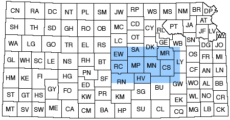
The region of study (fig. 1) encompasses approximately 7,500 mi2 (19,500 km2). To achieve an optimum number of well-control points, a goal of using at least one well per square mile, or section, was established. Of these 7,500 possible locations, only 3,794 wells actually were used. This was primarily because of the lack of drilling in various parts of the region. In areas where many wells exist, such as oil fields, the data were examined for consistency and only a few of the deepest wells were chosen. Although this limits the intricate analysis of minor structures that may be of importance in any further tectonic studies, regional structures are well defined.
Figure 1--Index map showing location of study area with respect to Kansas.
Cursory examination of the existing well records shows that the Mississippian carbonate rocks are an important target for hydrocarbon exploration. Therefore, to arrive at an internally consistent dataset, only those wells that penetrate these rocks were considered. Thus, several thousand wells that do not reach the Mississippian were not used in this study.
A series of six maps was constructed to demonstrate the development of structures in three dimensions. The horizons were chosen based upon an examination of available data, ease of identification, potential economic interest, and knowledge concerning the timing of regional tectonic movements. The units, with the number of control points for each, are
The maps were constructed using readily available data as sources. These include
Inconsistencies within the dataset represent either true structures or misidentified calls. Approximately 10% of all wells showed errors on the completion cards for one or more reported tops.
The formation tops were entered into a computer data base specifically designed for this project. This greatly aided well editing and base-map construction. Each well entry also included a descriptive and latitude-longitude location, an elevation, and a unique code number.
Well locations were plotted on 152 USGS 7 1/2-min quadrangle maps. The uncertainty in the location varied between wells but was estimated to be less than 350 ft. To facilitate the construction of a base map, the well locations, expressed in a descriptive legal format, were modified to standard latitude-longitude notation by digitizing the various quadrangle sheets. These location data were then entered into the computer data base.
Base maps showing well locations and tops were constructed and plotted directly from this information. A mathematical algorithm to interpolate and to draw contour lines between points was not used because of structural complexity within the study area. Although useful in relatively undisturbed areas, the computer-mapping program could not interpret extensively faulted areas.
Computer programs to generate isopach values and to isolate various portions of the data base proved useful in the analysis of complexly deformed areas. Block diagrams were constructed using the SURFACE II computer-graphics system.
The maps were constructed to gain insight into the structural history of the Precambrian basement and its influence on the overlying Paleozoic rocks. Because of sparse well control, a map of the structural configuration of the basement was not made. Although a sufficient number of wells penetrate the top of the Arbuckle, no extrapolation was attempted from the lowest recorded depth to the basement, as with previous maps (Cole, 1976).
Many subsurface structural maps of Kansas were drawn using contour intervals of 100 ft (30 m) or more. Although useful in regional reconnaissance mapping, these intervals are ill-suited for detailed structural analysis. Individual oil-field maps, which are typically contoured on a 10-ft (3-m) interval, are limited in areal coverage. A contour interval of 25 ft (8 m) offers a compromise between reconnaissance mapping, which may exclude many important structures, and detailed but cluttered maps showing each individual closure.
The role of faulting in the tectonic deformation of Kansas is controversial and not well understood. Detailed structural interpretations of individual oil fields indicate that faulting was a primary trapping mechanism (Thomas, 1927; Hiestand, 1933; Bunte and Fortier, 1941; Smith and Anders, 1951). Regional mapping suggests that faulting was an important process modifying the crust of central Kansas.
The early tectonic grain of the study area was dominated by northwest-trending structures. This basic pattern was established in the Proterozoic during the accretionary history of the Midcontinent. Initial structures were modified by Keweenawan-age rifting. Both terranes were characterized by extensive fault systems.
Because the rigid basement complex has been buried by only a thin layer of sedimentary rocks, stresses transmitted through the basement in response to subsequent Phanerozoic orogenies would tend to deform the overlying rocks in a brittle manner. Deformation would be concentrated along older zones of weakness (Sykes,1978).
Evidence of faulting in surface Paleozoic and younger rocks in Nemaha, Riley, Pottawatomie, Wabaunsee, and Chase counties is conclusive (Chelikowsky, 1970; Seyrafian, 1977; DuBois, 1978; Wilson, 1979). This faulting resulted from repeated tectonic disturbances that reactivated existing structures (Willoughby and Berendsen, 1978). Some faults remain active, as evidenced by present-day microseismicity (Wilson, 1979).
Well-defined linear trends are seen on satellite imagery (McCauley, 1978), in the alignment of streams and rivers (Berendsen and others, 1978), and even in the shape and location of many oil fields (Paul and others, 1982). Aeromagnetic and gravity maps show similar trends (Yarger, 1983; Yarger and others, 1981, 1985). Studies show that regional discontinuities in the physical and chemical properties of ground water occur (Berendsen and Hathaway, 1981; Denne and Hathaway, 1983; Macfarlane and Hathaway, in preparation). Although controversial, our interpretation is that some of these discontinuities may be caused by faults that act as barriers to the movement and mixing of water within aquifers. It is our opinion that the faults detailed on the maps are probably a conservative representation of the number of faults occurring in the study area.
In summary, brittle deformation played an important role in the tectonic development of Kansas. Preexisting basement structures were reactivated throughout the Phanerozoic. The resulting movements are recorded in the overlying sedimentary sequence. Some surface linear trends are subtle expressions of these basement structures.
An important conclusion reached from this study is that the structural complexity of each mapped interval increases with depth. The youngest Precambrian rocks directly beneath the Cambrian-Ordovician section are 1,100 m.y. old (Bickford and others, 1981). The unconformity between the Phanerozoic and Precambrian rocks represents approximately 600 m.y. for which there is no geologic record. Therefore, the structure of the Precambrian basement must be considerably more complex than the Arbuckle surface.
Faults mapped in the subsurface of Kansas are high-angle normal or reverse faults that parallel the established Precambrian structural trends. Listric faults and growth faults did not play an important role in the structural development of the area. Low-angle thrust faults that sole into a basal decollement are inconsistent with the basement-involved Paleozoic deformational style, although some Precambrian rift-related faults may flatten into a decollement zone at great depths (Serpa and others, 1984).
The only sure way to identify a fault in the subsurface is by drilling through the fault plane. In only a few documented instances has a borehole penetrated a fault. All other faults are to some extent inferred.
Linear zones of steep dip and strips along which map contours are consistently offset may imply faulting. Recognition of these features within more than one stratigraphic level was considered necessary. Compound offset between stratigraphic intervals was found to be a useful criterion in the delineation of faults. We assumed that a fault present in a mapped unit must cut the underlying older rocks as well. No minimum displacement criterium was used to define faults.
Faults were commonly extended into folds of minimum displacement. Some of the faults that have minor displacement likely are not as long as portrayed and may terminate in folds.
Precambrian basement rock types have been mapped and dated adequately (Bickford and others, 1981). However, our knowledge of structural elements extant prior to the Phanerozoic is limited. An understanding of these structures is important, for the framework of the Midcontinent has been greatly influenced by their later reactivation.
The best-understood Precambrian structural element is the Central North American rift system (CNARS; Ocola and Meyer, 1973). The structures within the rift system can be inferred from outcrops in the Lake Superior region and from geophysical data (Hamblin, 1965; Green, 1979; Serpa and others, 1984).
Intrarift basins in Kansas are filled by considerable thicknesses of Precambrian clastic sediments (Scott, 1966). The clastic influx was accommodated by a large amount of penecontemporaneous motion on bounding-fault systems.
The trend of the Central Kansas uplift-Cambridge arch-Chadron arch parallels a probable accretionary Proterozoic boundary. Elements associated with this boundary have influenced the later structural development of the region. An earlier positive structure preceding the Central Kansas uplift may have acted as a buttress and influenced the position of the CNARS.
First-order structural elements in the study area are the Central Kansas uplift, Nemaha uplift, Salina basin, Forest City basin, and Cherokee basin.
The development of regional tectonic features present at the end of the Precambrian has been adequately summarized by many authors (Merriam, 1963; Adler and others, 1971; Rascoe and Adler, 1983). As a result of tectonism associated with the Ouachita orogeny in post-Mississippian, pre-Desmoinesian Pennsylvanian time, a major structural change took place in Kansas. Thus, discussing the tectonic framework in terms of pre-Mississippian and post-Mississippian structural elements is convenient.
The ancestral Central Kansas uplift was an early Paleozoic precursor to the uplift formed at the end of the Mississippian. It is part of a major northwest-southeast-trending structural zone that probably originated in the Proterozoic. The zone includes the Chautauqua arch to the southeast and the Cambridge arch and Chadron arch to the northwest.
The North Kansas basin (Merriam, 1963) formed near the end of the Ordovician and existed until the Mississippian. This basin contained two distinct depocenters separated by a low divide (Nemaha uplift; Lee, 1939). These depocenters predated the present Salina and Forest City basins.
The occurrence of iron oolites of Middle Ordovician age in Nemaha and Marshall counties along the west side of the Nemaha uplift implies that the uplift was at least in some areas a positive feature during that time (Berendsen and Speczik, in preparation). Similar areas that were subaerially exposed during the Cambrian-Ordovician occur in the study area.
The Nemaha and the Central Kansas uplifts attained their present structural configuration in post-Mississippian, pre-Desmoinesian (Pennsylvanian) time (Merriam, 1963).
Post-Mississippian structures east of the Nemaha uplift include the Cherokee basin to the southeast, separated from the Forest City basin to the northeast by the Bourbon arch (Merriam, 1963). This arch forms a low divide between the two basins and had various degrees of influence on sedimentation until the Late Pennsylvanian (Harris, 1984).
The structural development of the area can largely be discussed in terms of repeated adjustments of structures concentrated along three major, through-going tectonic zones (fig. 2). These are the north-northeast-trending Nemaha and Peace Creek tectonic zones and the northwest-trending Fall River tectonic zone (FRITZ). The Pennsylvanian structural grain parallels these two prominent, preexisting basement trends.
Figure 2--Major tectonic elements of study area.
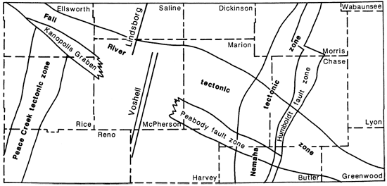
Structures oriented northeast-southwest parallel the 1,100-m.y.-old Central North American rift system. The Peace Creek and the Nemaha tectonic zones are considered to be related to the development of the CNARS.
The Nemaha tectonic zone incorporates all structures along the Nemaha uplift from southern Nebraska into Oklahoma. The Humboldt fault zone (HFZ) is mapped as a zone of closely spaced faults which flanks the complexly folded and faulted Nemaha uplift on the east side. Phipps (1983) reports that the Humboldt fault reverses throw along strike, which may suggest strike-slip faulting. Multiple anticlinal culminations and depressions along the axis of the Nemaha uplift further imply the wrench nature of the zone. This reactivated fold-fault system probably marks the eastern boundary of CNARS.
The Peace Creek tectonic zone forms the western boundary of the CNARS. Vertical displacement along the zone is not as great as that along the Humboldt fault zone. It seems to be truncated or at least to be disrupted by the FRITZ. A northern extension of the Peace Creek zone into the Salina basin may be displaced left-laterally to the west.
The Fall River tectonic zone (FRITZ) is recognized in the study area as an alignment of several northwest-trending structures, including the Kanopolis graben, the Peabody fault system, the Cottonwood fault, and the Fall River fault. Koester (1935) previously recognized a series of pre-Mississippian structural highs, the Wilson-Burns element, along the same trend.
Most structures previously recognized in the study area have been described comprehensively (Jewett, 1951; Merriam, 1963). Because the configuration of the structures has been deduced from drilling, they generally include the more important oil and gas reservoirs. The structures are identified in fig. 3.
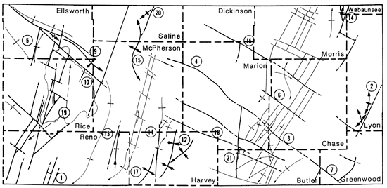
Figure 3--Structures recognized from previous studies (bold lines) are 1) Alma anticline, 2) Bluff City anticline, 3) Brownville syncline, 4) Burns dome, 5) Cedar Creek syncline, 6) Conway syncline, 7) El Dorado anticline, 8) Ellsworth anticline, 9) Ellsworth-Kanopolis anticline, 10) Elmdale dome, 11) Geneseo uplift, 12) Halstead-Graber structural trend, 13) Humboldt fault, 14) Rush rib, 15) Russell rib, 16) Voshell anticline, and 17) Walnut syncline.
This structure incorporates a series of folds, many faulted on the east side, approximately 9 mi east and parallel to the Nemaha uplift in Wabaunsee County (Smith and Anders, 1951; Merriam, 1963). The trend extends from near Council Grove in Morris County northeastward to at least Tarkio, Missouri (Paul and others, 1982). The southern terminus of this structure is the John Creek anticline.
This structure occurs in the south-central part of the area, approximately 12 mi west of the Nemaha uplift, and extends from southwestern Marion County to southwestern Harper County or farther (Barwick, 1928).
Although a single through-going structure is not recognized in the study area, the Florence-Urschel fold and the Elbing anticline comprise part of this structure.
Elbing anticline--The structure containing the Elbing oil pool in Butler and Marion counties was described by Thomas (1927). This structure is bounded on the west side by the north-trending Whitewater fault. Other northeast- and northwest-trending faults also influenced the localization of the oil.
Florence-Urschel fold--This is an anticlinal structure in Marion County that contains the oil pool by the same name (Barwick, 1928). The structure map shows that this fold is lobate with subsidiary anticlines and is probably better termed a dome.
The syncline east of the Nemaha uplift extending from southeastern Nebraska into northern Kansas was named by Dr. G. L. Smith of Iowa (Condra, 1927). Condra and others (1931) later extended it into southeastern Pottawatomie County. Jewett (1951) considers it to be a part of a synclinal area flanking the Nemaha uplift and extending across the state. Although a syncline extending to near Council Grove in northeastern Morris County is recognized, our data do not suggest a continuation south of Council Grove. To the south in Butler County, the Walnut syncline may be structurally equivalent.
This antiformal fold along the Nemaha uplift south of the Cedar Creek syncline was named by Prosser and Beede (1904).
The apex of Burns dome seems to be faulted on all four sides by northwest- and northeast-trending faults. At deeper structural levels within the lower Paleozoic sediments, a branching structure of subsidiary synclines and anticlines having a north-northeast trend is preserved above the basement.
Koester (1935) observed that this dome forms part of a series of structural highs extending in a northwesterly direction to eastern Russell County.
The Cedar Creek syncline (Prosser and Beede, 1904) is a structurally complex, graben-like feature astride the Nemaha uplift. The syncline is bounded on the north by the Elmdale dome and on the south by the Burns dome. The long axis of the syncline trends north-northeast.
Because of its location on the Nemaha uplift, the nature of this structure is problematic. Simple vertical uplift, as advocated by Fath (1921), does not account for its origin.
Post-Mississippian structural relief from the top of the Elmdale dome to the lowest part of the Cedar Creek syncline is 2,100 ft (640 m). The syncline shows 800 ft (245 m) of relief on the Lansing and is expressed at the surface as a 200-ft (60-m) depression near Wonsevu (Prosser and Beede, 1904). The structure is faulted on all sides, and additional data suggest that it is complexly faulted internally (Blair and Berendsen, 1985).
This feature was described by Koester (1935) as a major northeast-trending synclinal fold lying between the Voshell anticline and the Central Kansas uplift. It is considered to be a lobe of the Sedgwick basin.
The Diamond Creek province, which also includes the "Cottonwood province" (Prosser and Beede, 1904), was the first part of the Nemaha uplift to be recognized in Kansas. These two areas encompass the Elmdale dome, the Cedar Creek syncline, and the Burns dome. The terms predate the name "Nemaha uplift," and although they are no longer in use, they should have preempted the present terminology.
The El Dorado anticline is a sinuous anticlinal culmination on the Nemaha uplift (Fath, 1921), bounded on the east by the Humboldt fault and the Walnut syncline. Many prolific oil pools are located atop this structure. The anticline contains many subordinate folds, the Lincoln syncline and Chelsea dome being but two.
Chelsea dome--This feature (Fath, 1921) is a minor domal culmination on the northern flank of the El Dorado anticline. Located at the edge of the study area and extending to the south, it is not readily recognizable on the maps.
Lincoln syncline--This structural depression marks the northern and northwestern boundary of the Chelsea dome (Fath, 1921). Sparse control near the southern edge of the study area precludes clear definition of this feature. A prominent north-northeast-trending syncline extending to Burns dome may be a continuation of this structure. Alternatively, a northwest-trending scissors fault may limit the northern extension of the Lincoln syncline.
Ramsey syncline--The small synclinal fold separating the Chelsea dome from the Robinson dome to the southwest is located in sec. 2, T. 25 S., R. 5 E. (Fath, 1921), just south of the study area. Because Jewett (1951) incorrectly lists it as occurring in sec. 2, T. 24 S., R. 5 E., it is mentioned here.
The Ellsworth anticline was originally named to include a north-northeast-trending, relatively steep fold in west-central Rice County (Koester, 1935). It is here recognized as a linear trend of individual anticlinal, axial culminations bound on the west by a high-angle fault.
The Ellsworth-Kanopolis anticline, with an axis nearly normal to the Ellsworth anticline (Lee, 1939), intersects the trend of the latter on the north. A prominent northwest-trending fault zone separates the two features.
This trend of domal culminations, originally named by Lee (1939), flanks the Kanopolis graben on the north and intersects the Ellsworth anticline of Koester (1935) at a high angle.
The south limb of this structure is bounded by a major northwest-trending fault extending from near Langley to Wilson, Kansas (Cole, 1976). These structures represent a trend of pre-Mississippian folding and faulting which is traced from the Burns dome in the southeast.
This domal structure occurs along the crest of the Nemaha uplift southwest of the town of Elmdale in Chase County (Prosser and Beede, 1904). It displays a sigmoidal shape with subsidiary minor anticlinal and synclinal closures and is characterized by extensive erosion of pre-Pennsylvanian sediments and basement rock over the apex of the dome. The positive expression of this structure on the surface implies post-Permian movement (Berendsen and Blair, 1985).
The Elmdale dome is flanked to the east by the Humboldt fault zone, which in this vicinity has a maximum total throw of 1,100 ft (335 m) down to the east. Rocks dip gently west off the crest with some minor folding. A well-developed fault system occurs in pre-Mississippian rocks. Northwest-trending cross faults parallel to the older structural grain (Jewett, 1951) mark the approximate northern and southern boundaries of the dome. The structure is located just north of the intersection of the Fall River tectonic zone and the Nemaha uplift.
This structure was described in detail by Clark and others (1948) as the semi-detached eastern lobe of the Central Kansas uplift. Several major oil fields, including the Wherry, Welch-Bornholdt, Odessa, and Geneseo-Edwards, as well as the important Lyons gas field, occur along anticlinal culminations superimposed upon this broader structure. The accompanying maps show that the uplift is faulted on three sides. To the north, the pronounced northwest-trending Kanopolis graben terminates the uplift. An east-side-down normal fault recognizable in pre-Pennsylvanian sediments limits the eastern extension. The west side of the structure is bounded by a down-to-the-east fault showing displacement of Ordovician sediments. This fault is a component of the northeast-trending Peace Creek tectonic zone.
Lee (1939) gave this name to a number of northeast-trending anticlines in McPherson and Harvey counties. The maps indicate that the southern part of the structure, containing the Halstead and Sperling pools, is faulted on the west side by a north-trending fault. The structure exhibits several anticlinal culminations east of the west-side-down fault, which has a maximum displacement of 500 ft (150 m). Prominent synclines occur to the east and west of the Halstead-Sperling part of the trend. The Graber oil pools occur along northerly trending anticlinal structures that are offset to the east 3-4 mi.
This northeast-trending fault system extends from Nebraska into Kansas along the east side of the Nemaha uplift. It was first named by Condra (1927) and later discussed in more detail by Condra and Reed (1943). The trace of the fault is continuous to at least Sumner County, Kansas (Cole, 1976) and continues southward into Oklahoma (Burchett and others, 1983).
Studies now show that the Humboldt fault consists of a series of fault blocks stepped down to the east (Koons, 1956; Bruton, 1958; Seyrafian, 1977; DuBois, 1978; Willoughby and Berendsen, 1978; Blair and Berendsen, 1985). Some of these studies indicate that the fault is actually a zone made up of anastomosing faults.
Because of its complex nature this structure should more properly be referred to as the "Humboldt fault zone."
This feature is a structural high on top of the Central Kansas uplift and was described by Koester (1935) as extending from southeastern Barton County in a northwesterly direction through Ellis and Trego counties into Graham County. The southeastern extension probably can be correlated with a structural high, from which Simpson-age sediments are missing, that projects as a nose into southwestern Rice County.
This structural high, parallel to and genetically related to the Rush rib, was described by Koester (1935) as extending from southwestern Ellsworth County through Russell and Ellis counties into Rooks County. In Ellsworth County the approximate location of the Russell rib is marked by the erosional edge of Simpson rocks. A structural high is mapped on Arbuckle rocks.
The Voshell anticline has been a prolific oil-producing structure that was described in detail by Hiestand (1933) and Bunte and Fortier (1941). It was originally thought to be a north-northeast-trending, south-southwest-plunging anticlinal fold bounded on its west side by a high-angle reverse fault that shows as much as 400-ft (125-m) displacement.
The accompanying maps indicate that the structure is actually a horst, with the eastern-bounding fault being partially discontinuous in post-Ordovician rocks and showing a maximum displacement of 150 ft (45 m). The Burton pool at the southern end of the trend is faulted only on the east in pre-Mississippian rocks. Hiestand (1933) recognized an en echelon arrangement of the bounding faults and related cross fracturing. This alignment more closely represents a relay pattern of faults with offsets along northwest-trending cross faults.
The Voshell anticline coincides with the linear trend of gravity and magnetic highs associated with the Midcontinent Geophysical Anomaly (MGA).
This pronounced syncline bordering the El Dorado anticline to the east was named by Fath (1921). The structure shows approximately 1,600 ft (500 m) of relief on the Precambrian surface and is even expressed in the surface rocks. The structure is not well defined on the map as deep well control is lacking.
Note that our data do not support the usual interpretation of substantial drag folding along the trace of the Humboldt fault east of the Nemaha uplift, nor the creation of major synclinal structures paralleling the fault plane. Rather, units to the east of the fault continue to dip west upon contact with the fault.
Koester (1935) recognized that a tectonic zone represented by a line of pre-Mississippian warping could be traced from Burns dome in Butler County through the Peabody, Ritz-Canton, and McPherson oil fields and two high areas of "siliceous lime" (Arbuckle) to the Russell-Ellsworth County line. One such high area occurs in north-central Ellsworth County and is characterized by the erosion of most pre- Pennsylvanian sediments except for the Arbuckle limestones.
We recognize the Wilson-Burns element as an integral structure of the Fall River tectonic zone that extends across the study area and beyond.
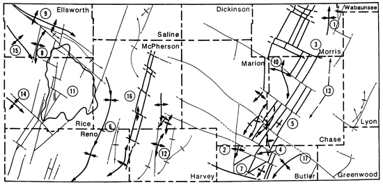
The regional scope of this project enabled the identification of a number of large structures, some unknown, others previously recognized but not named. These include faults and folds as well as larger structural trends. To facilitate discussion, we here propose names for the more important features (fig. 4).
Figure 4--Structures recognized in this study (bold lines) are 1) Abbyville structure, 2) Bradfield fault, 3) Cedar Creek fault, 4) Cottonwood fault, 5) Ellsworth fault, 6) Elmdale fault, 7) Fall River fault, 8) Kanopolis graben, 9) Black Wolf fault, 10) Crawford fault, 11) Halstead fault, 12) Heston syncline, 13) Hutchinson fault, 14) John Creek fault, 15) Lindsborg anticline, 16) Lost Springs trend, 17) Patterson syncline, 18) Peabody fault system, 19) Peace Creek tectonic zone, 20) Salina fault, and 21) Whitewater fault.
The Abbyville structure is located in T. 23 and 24 S., R. 8 W., and consists of two parallel, northeast-trending faulted anticlines. The structure was recognized by Cole (1976) as a sharp, northeast-elongated, domal closure on the basement. Mississippian and Kinderhook-age rocks have been removed over the crest of the western-most anticline. The structural system extends south of the map area.
The faults were active at least through Lansing time and have maximum throws on the order of 150-300 ft (45-90 m).
The northeast-trending Bradfield fault borders an oil field by the same name in T. 22 S., R. 10 E., and extends to at least T. 19 S., R. 11 E. The fault was active prior to Lansing time. It reverses throw along strike. The southern part of the fault is downthrown to the east, with a maximum throw of 150 ft (45 m). North of the hinge point, the foot wall is on the west and has a displacement of 75 ft (25 m).
The northwest-trending Cedar Creek fault bisects the Cedar Creek syncline, separating several individual fault blocks. In the central trough of the syncline north of the fault, pre-Pennsylvanian rocks are approximately 1,000 ft (305 m) lower than in the bounding blocks to the west, south, and east. This fault probably is continuous in the basement with the Cottonwood fault to the west and the Fall River fault to the east.
The fault has a northwesterly trend and extends from T. 18 S., R. 1 W., in northeast McPherson County to T. 21 S., R. 5 E., in southeast Marion County, where it terminates against the northeast-trending Florence-Urschel fold. However, the fault is believed to continue as a basement structure farther to the southeast and can be recognized as the Cedar Creek fault described above. This feature can be recognized in pre-Mississippian rocks, with only a small segment active in Mississippian time. Displacement along the fault varies, and the south block always has a relative down motion.
This northeast-trending normal fault extends through T. 16 S. to T. 17 S., R. 9 W., and flanks the Ellsworth anticline (Koester, 1935). Maximum throw is 200 ft (60 m) down to the west. The fault is terminated to the north by the Black Wolf fault of the Kanopolis graben system. The latest movement on this fault took place prior to the end of Lansing time.
The northwest-trending Elmdale fault in Chase County separates the Cedar Creek syncline to the south from the Elmdale dome to the north. Lack of data prevents an accurate estimate of the maximum throw on the fault, but it is believed to be well in excess of 1,000 ft (305 m). As a result of post-Mississippian erosional processes, Mississippian rocks south of the fault are in contact with basement rocks north of the fault.
The southeast extension of the Cottonwood-Cedar Creek fault system in northeast Butler and western Greenwood counties is referred to as the Fall River fault, because of its alignment with the river. At the boundary of the two counties, a northeast-trending scissors fault terminates against the Fall River fault. West of this point, the movement on the fault is down to the south, with a maximum displacement of Arbuckle rocks of 50 ft (15 m). To the east the movement is in the opposite direction, but shows a similar displacement. Except for a small segment near the boundary of the study area, the fault does not seem to have been active past Viola time.
The Fall River tectonic zone (FRITZ) incorporates the Wilson-Burns element of Koester (1935) and is considered to be of regional significance. The northwest-southeast-trending zone is expressed discontinuously across the study area (150 mi, 240 km). It is up to 25 mi (40 km) wide. Starting in the northwest some integral structural elements of the zone are the Ellsworth-Kanopolis anticline, Kanopolis graben, Black Wolf fault, Cottonwood fault, Peabody fault system, Cedar Creek fault, Fall River fault, Cedar Creek syncline, and Burns dome (figs. 3 and 4). A number of small domal and anticlinal culminations in Arbuckle rocks (the "siliceous lime" of Koester, 1935) occur along this trend. Additionally, at least one small area of Precambrian quartzite is subcropping below the Simpson in sec. 22, T. 19 S., R. 2 E. (Bickford and others, 1984; Cole and Ebanks, 1979) and may be related to this trend.
This deep trough, located in Ellsworth, Rice, and McPherson counties, extends from T. 16 S., R. 9 W., southeastward towards the town of McPherson. It separates the Ellsworth anticline and the Geneseo uplift from the Ellsworth-Kanopolis anticline on the north. The graben is approximately 5 mi (8 km) wide at the junction with the Conway syncline and narrows to a point toward the northwest. It is bounded by two high-angle normal faults (Black Wolf, Crawford) and is broken by a cross fault into two separate "stairstep" blocks.
The graben corresponds with the hilly upland terrain south of the Smoky Hill River. The present-day river valley is apparently not related to the subsurface structural geology.
Black Wolf Fault (9)--This fault appears on the Precambrian surface map (Cole, 1976), extending from T. 14 S., R. 11 W., to T. 17 S., R. 6 W. It bounds the Kanopolis graben on the north and curves to a more northwest trend near its junction with the Crawford fault and Ellsworth anticline at the western end of the graben.
The eastern part remained active at least through Lansing time. The latest movement on the western extension of the fault is difficult to document because of post-Mississippian erosion. The maximum throw is 500 ft (150 m) on Arbuckle rocks and varies along strike.
Crawford Fault (10)--The Crawford fault extends from the intersection of the Ellsworth anticline with the Black Wolf fault along the flank of the Geneseo uplift and is the southern-bounding fault of the Kanopolis graben. It extends into western McPherson County where it is terminated by the Salina fault.
Throw ranges from 50 to 300 ft (15-90 m) along strike. The fault can be documented in Mississippian rocks, but Lansing rocks are drape-folded over the fault.
This fault borders the Halstead-Sperling anticline on the west and appears on the Kansas basement map (Cole, 1976). The structure is located entirely in west-central Harvey County. It has a maximum offset exceeding 400 ft (125 m) at the top of the Mississippian. Displacement is down to the west. The Halstead fault remained at least active through Lansing time, when the maximum throw was reduced to 100 ft (30 m).
This syncline, at the northern margin of the Sedgwick basin, occurs in central Harvey County east of the Halstead-Graber anticlinal trend. Its axis trends north-northeast and terminates against the Peabody fault system. The syncline probably merges with the Patterson syncline south of the intervening anticlinal trend. The structure bifurcates near the southern junction with the Sedgwick basin, with the eastern lobe extending into eastern Harvey County.
Located in eastern Reno and southern McPherson counties, this fold-fault system flanks the Conway syncline. Displacement is down to the east, with a maximum throw of 75 ft (25 m). The structure is expressed as an anticlinal nose in post-Viola time, indicating that displacement along the fault was minimal. A small, closed basin occurs east of this structure.
The John Creek fault system is the southern part of a linear trend of faulted anticlinal closures (Alma anticline) east of the Nemaha uplift in eastern Morris and southern Wabaunsee counties.
The John Creek structure is bounded on the east by a sinuous, high-angle reverse fault having a maximum throw of 150 ft (45 m). Several productive anticlinal closures occur along the trace of the fault. The fault remained active through Lansing time. The southern end of the structure is intersected by a northwest-trending scissors fault in pre-Chattanooga rocks.
The north-northeast-trending Lindsborg anticline extends at least from Salina in central Saline County into McPherson County. Many individual culminations occur along the anticlinal axis. The axis bends sharply to the southeast within the Fall River tectonic zone. The anticline is abruptly truncated by the Voshell fault. From T. 16 S., R. 3 W., northward, the structure is bounded on the east by a fault having an east-side-down displacement of 175 ft (55 m). The fault cuts Pennsylvanian rocks.
Several discontinuous northwest-trending fault segments make up the Lost Springs structural trend. The trend extends across the study area from central Dickinson County through Marion, Morris, and Chase counties, to at least northern Greenwood County. It is a basement structure similar to the Fall River tectonic zone, which it parallels.
The western fault segment is a scissors fault. The pivot point, in T. 17 S., R. 4 E., can be seen at the Arbuckle level. The lack of data prohibits accurate mapping of the western part of this scissors fault, but it is believed to have a minimal down-to-the-south throw of 50 ft (15 m). The eastern part cuts the west flank of the Nemaha uplift and is well documented in pre-Pennsylvanian rocks. The fault cannot be traced continuously eastward across the northern limb of the Elmdale dome.
A probable extension of the fault is identified on the east flank of the Elmdale dome and extends across the Humboldt fault system. This portion of the fault is shown on the basement contour map of Cole (1976). Displacement exceeds 900 ft (275 m) and offset on Lansing rocks is as much as 350 ft (100 m). Erosional patterns, developed as a result of post-Mississippian reactivation of the Nemaha uplift, were strongly influenced by the fault.
The southeast extension of this fault trend is seen in northern Greenwood County, where an unnamed fault having a maximum down-to-the-south throw of 125 ft (40 m) terminates the Bradfield fault. This segment was active in pre-Mississippian time.
This synclinal fold occupies the area between the Voshell anticline and the Halstead-Graber trend and continues southward into the Sedgwick basin. At the map border, it merges with the Heston syncline.
The Peabody fault system extends from southeast McPherson County into north-central Butler County. It trends northwest and consists of two sets of faults 3-6 mi (5-10 km) apart. The system is interrupted by north- and northeast-trending cross faults.
The bounding faults are in places aligned to form a low graben; in other locations, the fault blocks are arranged in a "stairstep" fashion. The Burns dome on the Nemaha uplift, located at the intersection of this system with the Humboldt fault zone, is the only uplifted block along the trend.
The two southern fault segments, extending from T. 22 S., R. 3 E., to T. 21 S., R. 1 W., have an opposite sense of displacement, which implies that they formed over a continuous scissors fault in the basement. We regard the Peabody fault system as the extension of the Kanopolis graben. The trend forms the southern boundary of the Fall River tectonic zone.
A north-northeast-trending disturbed zone, approximately 9 mi (15 km) wide, occurs within the eastern flank of the Central Kansas uplift. Individual faults identified within this zone comprise a complex set of anastomosing structures. Northwest-trending cross faults also occur. The Ellsworth anticline (Koester, 1935) and attendant fault are part of the same structural trend.
The flank of the Central Kansas uplift east of the Peace Creek system (Geneseo uplift) is relatively undeformed. It is dominated by subsidiary structures aligned north-northeast and north-northwest. West of the Peace Creek tectonic zone, the structural grain of the Central Kansas uplift is aligned dominantly northwest.
The system contains many subsidiary anticlines and synclines. Normal, high-angle reverse, and scissors faults are common. The zone is characterized by horsts, grabens, and a series of "stairstep"-arranged fault blocks, similar to those within the Humboldt fault system, and most having a displacement down to the east. The occurrence of both stratigraphically and structurally controlled oil and gas fields parallel to the trend proves the influence of these structures upon sediment deposition and hydrocarbon migration.
The trend, although it may continue to the north in the basement, is interrupted by the Fall River tectonic zone. The system continues to the south beyond the boundary of the area, as evidenced by the alignment along strike of similar structures in the basement (Cole, 1976).
The en echelon alignment of minor anticlinal folds and faults (Newell, in preparation) as well as faults that reverse throw along strike suggest that this system formed in a wrench tectonic environment.
This major north- northeast-trending fault extends from T. 20 S., R. 6 W., to at least T. 15 S., R. 4 W. It is shown on the basement-contour map as a synclinal reentrant extending into Nebraska (Cole, 1976).
North of the junction with the Kanopolis graben, throw is down to the west and varies from 0 ft at the intersection to 200 ft (0-60 m) at the northern map edge in pre-Pennsylvanian units. To the south displacement is reversed and ranges up to 100 ft (30 m). In the northern-most segment flanking the Lindsborg anticline, the fault cuts Lansing rocks.
The Abbeyville structure to the south may lie on the same linear basement trend as the Salina fault.
The Whitewater fault is a north-trending normal fault extending from T. 20 S. to T. 24 S., R. 4 E., in Marion and Butler counties. The fault flanks the Nemaha uplift on the west. It intersects the Cottonwood fault in Arbuckle rocks north of the Covert-Sellers oil field. A short north-trending fault segment in T. 17 S., R. 4 E., is related to the same basement trend. To the south, the structure terminates against an unnamed northwest-trending fault which may be related to the Lincoln syncline.
The fault becomes discontinuous in younger units and is absent in the Lansing. The trend converges upon the Humboldt fault zone at a low angle. The throw along the fault varies because it borders blocks of differing elevation within the Nemaha uplift. Maximum offset in the Lower Ordovician units is 200 ft (60 m).
Pre-Pennsylvanian movement along the fault is shown by individual small areas of erosion of Mississippian carbonate rocks east of the fault trace. Producing oil fields (Covert-Sellers, Peabody, Speir A., Elbing) are associated with these areas.
Many of the structures defined by contour mapping may also be recognized using indirect methods. Some subsurface structures may be seen on aerial photographs or satellite imagery or may be deduced from an orientation study of river and stream valleys. Distinct trends of oil and gas fields may be useful in defining new exploration targets. Finally, some structures are visible on gravity and magnetic maps of the area.
Subsurface structures are often expressed at the surface. Berendsen and others (1978) noted the pronounced linearity of major stream and river valleys in eastern Kansas. The valleys show two distinct preferred orientations: north-northeast and northwest. These directions also define the structural grain in the state.
In many instances, these stream and river valleys can be demonstrated to be associated with major faults or fault zones. The Black Wolf fault follows the trace of the Smoky Hill River. The Cottonwood and Fall River faults parallel their namesake rivers, and other faults of the Fall River tectonic zone parallel and underlie major stream valleys. Similar examples of structurally influenced stream valleys include Turkey Creek, which lies along the Voshell trend; the Whitewater River, which follows the fault by the same name; and Cedar Creek, which parallels the fault bounding the south end of the Cedar Creek syncline.
Not all river valleys are associated with fault trends in the subsurface. The Neosho River, which has a very linear channel, does not seem to be associated with any major fault system within the map area.
Subsurface structures may also be expressed on the surface as slope breaks and as boundaries between rugged and subdued terrain. Topography west of the Humboldt fault in the vicinity of the Elmdale dome is much rougher than that east of the fault. To the west, structure also is expressed by an increase in the dip of surface rock exposures. Northward from here, the west side of the Nemaha uplift is characterized by a boundary between relatively flat and hummocky terrain. Similarly the Crawford fault, which bounds the south side of the Kanopolis graben, defines a ridge south of and parallel to the Smoky Hill River valley.
Surface faults are associated with the various tectonic zones. Faulting along the Nemaha tectonic zone in northern Kansas is well documented (Chelikowsky, 1970; DuBois, 1978; Seyrafian, 1977). Similarly, a zone of en echelon faults crop out north of the town of Elmdale on the flank of the Elmdale dome (J. McCauley, personal communication, 1985) in Chase County.
The two prevalent structural trends in Kansas, northwest and north-northeast, were established in the Precambrian. The location of many oil fields can be related directly to reactivated basement structures. Because these basement trends are continuous, first-order structural elements of the continent (e.g., CNARS), they can be used to delineate new exploration targets, as in the deeper parts of the Salina basin and, perhaps, within the rift itself. The timing of motion on these structures would, of course, place certain limits on the migration of hydrocarbons into their respective traps.
The Nemaha uplift and associated structures were among the first in Kansas to produce major amounts of oil and gas. This northeast-trending zone of faults and folds was recognized very early as having been developed along a preexisting Precambrian zone of weakness (Fath, 1920, 1921). The Voshell anticline and other structures having similar northeast trends formed over basement structures as well.
Fields over the Central Kansas uplift are aligned along pronounced northwest trends. The string of oil fields (Click, Crawford, and Odessa) south of the Kanopolis graben, and the Stoltenberg and Kraft-Prusa oil fields over the Rush rib, are good examples of these trends (map 7).
The aeromagnetic and Bouguer gravity maps of Kansas (Yarger and others, 1981, 1985) display trends and signatures that correlate with observed basement terranes and structures (fig. 5). These trends may be further enhanced using various filtering techniques. These techniques, as well as possible interpretations of some of the linear trends and signatures, are discussed by Yarger (1983).
Figure 5--Annotated aeromagnetic map of Kansas; study area outlined.
A magnetic quiet zone, corresponding to the clastic rocks of the late Precambrian Rice Formation (Scott, 1966), surrounds the sinuous magnetic high of the Midcontinent Geophysical Anomaly. This quiet zone is sharply defined, implying that the associated rift basins are fault bounded.
We believe that northeast-trending magnetic linears which cross the eastern flank of the Central Kansas uplift are associated with the Peace Creek tectonic zone. If these linears actually represent basement faults, then the Peace Creek system must be regarded as a major tectonic zone defining the western edge of the Rice basin. An area of distinct linears in the Salina basin parallel to and northwest of the Peace Creek zone may represent a similar fault zone bounding the Rice basin on the west.
The sinuous gravity and magnetic highs associated with the mafic intrusive and extrusive rocks of the rift underlie the Lindsborg and Voshell anticlines. This relationship implies that the mafic magmas of the rift were emplaced along fault-bounded blocks which were subsequently reactivated to form the Lindsborg and Voshell structures. The geophysical anomaly is offset left-laterally 7 mi (11 km) between the anticlines along the Fall River tectonic zone.
The Fall River tectonic zone continues to the northwest and southeast outside the map area. It is expressed as an alignment of topographic and geophysical linear trends extending from the Platte River in western Nebraska through Kansas and northeastern Oklahoma into Arkansas. The structural zone marks the northern boundary of a magnetic low in Butler and Greenwood counties. The southern part of the Precambrian Rice basin is partially defined by this system. The Peace Creek tectonic zone is truncated by the FRITZ.
The Nemaha tectonic zone and the Humboldt fault system are not well defined by geophysical expressions within the map area. The approximate eastern boundary of the southern lobe of the magnetic low in Butler and Greenwood counties corresponds to the Humboldt fault zone.
A relatively intense magnetic high is located in southern Morris County. The anomaly is associated with the Elmdale dome and occurs at a major, left-lateral offset of the Humboldt fault system. It apparently represents a large basement structure that influenced the position of the younger Humboldt fault zone.
The present structural configuration of Kansas is the product of repeated reactivation of earlier tectonic trends. This complicated regional structure has generally been dealt with in a simplified manner. Detailed analyses of many structures suggest that they resulted from the complex interaction of forces compounded over long periods of time.
Kansas has been far removed from any active plate margin throughout the Phanerozoic. However, at least one Paleozoic orogenic event, the Carboniferous Ouachita orogeny, had a profound effect on the tectonic development of the state. During this orogeny, many important geologic structures were formed by vertical and lateral basement faulting.
The en echelon alignment of faults and folds in rocks above the basement may imply a wrench motion at depth (Wilcox and others, 1973). This relationship between structures has been noted many times throughout Kansas (Fath, 1921; Foley, 1926; Hiestand, 1933; Jewett, 1951; DuBois, 1978; Blair and Berendsen, 1985). Most of the folds and faults display an alignment implying formation in a left-lateral stress field. Other structures common to wrench systems are anticlinal culminations and depressions; pull-apart basins; antithetic fault systems; and propeller and scissors faults, along which throw is reversed. Examples of each are evident throughout the map area.
Fath (1920, 1921) was among the first to appreciate the importance of both lateral movement and basement reactivation in the structural development of Kansas. Fath hypothesized that left-lateral movement along ancient zones of weakness in the basement was responsible for the formation of certain Paleozoic structures. He concluded that this was the case for narrow bands of en echelon faults cropping out in north-central Oklahoma. However, Fath did not draw the same conclusion for the "buried granite ridge"--the structure now known as the Nemaha uplift. There he favored vertical uplift along a preexisting Precambrian shear zone. Lack of an extensive data base of wells prevented Fath from mapping the uplift accurately.
Detailed mapping of structures located within the Nemaha tectonic zone suggests that deformation involved a significant component of lateral motion. The Cedar Creek syncline is an illustrative example.
The Cedar Creek syncline, located at the intersection of the Nemaha and Fall River tectonic zones, is a major, downdropped block displacing the Humboldt fault. The geometry of the structure does not follow from a simple vertical uplift of the ridge, as advocated by Fath (1920, 1921). Left-lateral motion must be invoked.
Precambrian left-lateral motion along the Fall River tectonic zone offset the geophysical anomalies at the junction of the Voshell and Lindsborg anticlines. A Precambrian precursor to the Humboldt fault must have similarly been displaced (figs. 6a and b).
Figure 6--Schematic tectonics of Cedar Creek syncline illustrating wrench motions. a) Initiation of structures in Proterozoic. b) Post-rift left-lateral motion on Fall River tectonic zone. c) Oblique wrench motion on Humboldt fault during Carboniferous Ouachita orogeny.
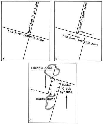
Detailed analysis shows that subsequent motion along the Humboldt fault zone during the Carboniferous Ouachita orogeny created a deep, faulted, rhomboidal-shaped basin at this location. Such structures, called pull-apart basins, are indicative of wrench environments (Crowell, 1984). An accompanying compressional component of movement accounts also for the synchronous folding of the Elmdale and Burns domes (fig. 6c). The total lateral displacement of the structure is not known but must be on the order of a few kilometers.
We believe that similar structures occur elsewhere in Kansas, as for example in Butler and Pottawatomie counties. One may expect them to be present in the subsurface flanking the trend of the Central North American rift system northward into Minnesota.
Younger faults exposed at the surface also indicate lateral tectonism. A series of en echelon faults on top of the Elmdale dome in Chase County are associated with the Lost Springs fault trend. Their alignment suggests formation in a right-lateral wrench zone. The faults must be Permian or younger and may be related to the interaction of the Permian Marathon orogeny or the Late Cretaceous-Early Tertiary Laramide orogeny on the older Nemaha uplift.
The three major tectonic zones (FRITZ, Nemaha, and Peace Creek) are related to important Precambrian-basement discontinuities. The Nemaha and Peace Creek tectonic zones represent the reactivated eastern and western boundaries of the CNARS. The FRITZ parallels a Precambrian structural trend that may be related to plate accretion along the margin of the Churchill province (about 1,800-1,600 m.y.).
Although FRITZ coincides with the major, transcontinental transform fault proposed by Kinsland (1985), a different interpretation of the structure is favored. We believe that there have been only 7 mi (11 km) of left-lateral motion along the structure.
This study shows the value of using a large data base to interpret the structural geology of an area previously considered to be relatively undeformed. The resulting six structural contour maps add to our understanding of the tectonic development of Kansas and suggest the complexity to be expected in neighboring areas.
We recognize three major tectonic zones that correspond closely to Precambrian-basement structures and/or terrane boundaries. The northeast-trending Nemaha tectonic zone is a complexly deformed, fold-fault system incorporating high-angle normal, reverse, and strike-slip faults; basement-cored, faulted, domal culminations and anticlines; and deep, faulted, pull-apart grabens. The tectonic zone is the reactivated eastern boundary of the 1,100m.y.-old Central North American rift system (CNARS).
The Peace Creek tectonic zone, containing similar structures, is located along the eastern flank of the Central Kansas uplift. This structural system is the reactivated western boundary of CNARS.
The Fall River tectonic zone is a major, northwest-trending system of folds and faults that intersects the previously defined structures. This zone parallels the southern boundary of the Proterozoic Churchill accretionary terrane.
These zones and the structures contained within them were deformed throughout the Phanerozoic, with the major motion occurring at the end of the Mississippian. They are considered to be foreland expressions of the Pennsylvanian Ouachita orogeny to the south.
Major structures, including high-angle normal and reverse faults, scissors and propeller faults, anticlinal culminations and depressions, pull-apart basins, and the en echelon arrangement of faults found throughout the study area, document that a wrench style of deformation was prevalent during the Carboniferous.
Using the approach employed here, we were able to better identify and to map many individual structures, such as the Humboldt fault zone. Some of the more important structures first identified here include the Kanopolis graben, the Lindsborg anticline, the Whitewater and Salina faults, and the Peabody fault system.
The multidisciplinary approach of this study has proved very successful. Recent advances in geophysical and remote-sensing techniques make it possible to delineate trends that have been correlated with actual structures. Studies of this kind allow us to gain a better understanding of the tectonic processes operative throughout time and should be of value in the continuing search for hydrocarbon and mineral resources.
Adler, F. J., Caplan, W. M., and others, 1971, Future petroleum provinces of the Midcontinent region; in, Future Petroleum Provinces of the United States--Their Geology and Potential: American Association of Petroleum Geologists, Memoir 15, v. 2, p. 985-1,120
Barwick, J. S., 1928, The Salina basin of north-central Kansas (with discussion): American Association of Petroleum Geologists, Bulletin, v. 12, no. 2, p. 177-199
Berendsen, P., Wilson, F. W., Yarger, H., and Steeples, D. W., 1978, New data on major basement fractures in the tectonic development of eastern Kansas; in, Proceedings of the Third International Conference on Basement Tectonics, D. W. O'Leary and J. L. Earle, eds.: Basement Tectonics Committee, Denver, p. 227-240
Berendsen, P., and Hathaway, L. R., 1981, Uranium in unconsolidated aquifers of western Kansas: Kansas Geological Survey, Mineral Resource Series 9, 43 p. [available online]
Berendsen, P., and Blair, K. P., 1985, Basement control on the tectonic development of Kansas (abs.): Kansas Academy of Science, Annual Meeting 117, p. 6
Berendsen, P., and Speczik, S., in preparation, Simpson-age (Middle Ordovician) rocks associated with the Nemaha uplift, northeast Kansas
Bickford, M. E., Harrower, K. L., Hoppe, W. J., Nelson, B. K., Nusbaum, R. L., and Thomas, J. J., 1981, Rb-Sr and U-Pb geochronology and distribution of rock types; in, The Precambrian Basement of Missouri and Kansas: Geological Society of America, Bulletin, part 1, v. 92, p. 323-341
Bickford, M. E., Van Schmus, W. R., Yarger, H. L., Hickman, K. D., and Cole, V. B., 1984, Geologic map of the Precambrian surface including terranes, ages, faults, and linears: unpublished map, scale 1:500,000
Blair, K. P., and Berendsen, P., 1985, Structures associated with strike-slip faulting in Kansas (abs.): Kansas Academy of Science, Annual Meeting 117, p. 8
Brookins, D. G., 1970, Factors governing the emplacement of Riley County, Kansas, kimberlites: Kansas Geological Survey, Bulletin 199, part 4, 17 p. [available online]
Bruton, R. L., 1958, The geology of the fault area in southeast Riley County, Kansas: M.S. thesis, Kansas State University, 44 p.
Bunte, A. S., and Fortier, L. R., 1941, Nikkel Pool, McPherson and Harvey counties, Kansas; in, Stratigraphic-type Oil Fields: American Association of Petroleum Geologists, p. 105-117
Burchett, R. R., Luza, K. V., Van Eck, O. J., Wilson, F. W., 1983, Seismicity and tectonic relationships of the Nemaha uplift and the Midcontinent Geophysical Anomaly: U.S. Nuclear Regulatory Commission, NUREG/CR-3117, 33 p.
Chelikowsky, J. R., 1970, Structural geology of the Manhattan, Kansas, area: Kansas Geological Survey, Bulletin 204, part 4, 13 p. [available online]
Clark, S. K., Arnett, C. L., and Royds, J. S., 1948, Geneseo uplift, Rice, Ellsworth, and McPherson counties, Kansas; in, Structure of Typical American Oil Fields: American Association of Petroleum Geologists, v. 3, p. 225-248
Cole, V. B., 1962, Configuration on top of Precambrian basement rocks in Kansas: Kansas Geological Survey, Oil and Gas Investigations 26 [available online]
Cole, V. B., 1976, Configuration of the top of Precambrian rocks in Kansas: Kansas Geological Survey, Map M-7, scale 1:500,000 [available online]
Cole, V. B., and Ebanks, W. J., Jr., 1979, List of Kansas wells drilled into Precambrian rocks: Kansas Geological Survey, Subsurface Geology Series 3, 107 p.
Condra, G. E., 1927, The stratigraphy of the Pennsylvanian System in Nebraska: Nebraska Geological Survey, Bulletin 1, 291 p.
Condra, G. E., and Reed, E. C., 1943, The geologic section of Nebraska: Nebraska Geological Survey, Bulletin 6, 2nd series, p. 1-82
Condra, G. E., Upp, J., and others, 1931, Correlation of the Big Blue Series in Nebraska: Nebraska Geological Survey, Bulletin 6, 74 p.
Crowell, J. C., 1984, Origin of Late Cenozoic basins in southern California; in, Wrench-fault Tectonics, A. G. Sylvester, comp.: American Association of Petroleum Geologists, Reprint Series, no. 28, p. 195-209
Denne, J. E., and Hathaway, L. R., 1983, Nitrogen speciation and the potential for trihalomethane formation in ground water from glacial buried-valley aquifers in northeastern Kansas (abs.): Geological Society of America, Abstracts with Programs, v. 15, no. 6., p. 556
DuBois, S. M., 1978, The origin of surface lineaments in Nemaha County, Kansas: M.S. thesis, University of Kansas, 37 p.
Ensign, C. O., Jr., White, W. S., Wright, J. C., Patrick, J. L., Leone, R. J., Hathaway, D. J., Trammell, J. W., Fritts, J. J., and Wright, T. L., 1968, Copper deposits in the Nonesuch Shale, White Pine, Michigan; in, Ore Deposits of the United States, 1933-1967, The Graton-Sales Volume, J. D. Ridge, ed.: American Institute of Mining, Metallurgical, and Petroleum Engineers, New York, p. 460-488
Fath, A. E., 1920, The origin of the faults, anticlines, and buried "granite ridge" of the northern part of the Midcontinent oil and gas field: U.S. Geological Survey, Professional Paper, no. 128, p. 75-84 [available online]
Fath, A. E., 1921, Geology of the El Dorado oil and gas field, Butler County, Kansas: Kansas Geological Survey, Bulletin 7, 188 p. [available online]
Foley, L. L., 1926, The origin of the faults in Creek and Osage counties, Oklahoma: American Association of Petroleum Geologists, Bulletin, v. 10., no. 3, p. 293-303
Green, J. C., 1979, Field trip guidebook for the Keweenawan (upper Precambrian) North Shore Volcanic Group, Minnesota: Minnesota Geological Survey, University of Minnesota, Guidebook Series, no. 11, 22 p.
Hamblin, W. K., 1965, Basement control of Keweenawan and Cambrian sedimentation in Lake Superior region: American Association of Petroleum Geologists, Bulletin, v. 49, no. 7, p. 950-958
Harris, J. W., 1984, Stratigraphy and depositional environments of the Krebs Formation, Lower Cherokee Group (Middle Pennsylvanian), in southeastern Kansas: M.S. thesis, University of Kansas, 139 p.
Hiestand, T. C., 1933, Voshell field, McPherson County, Kansas: American Association of Petroleum Geologists, Bulletin, v. 17, no. 2, p. 169-191
Jewett, J. M., 1951, Geologic structures in Kansas: Kansas Geological Survey, Bulletin 90, part 6, p. 105-172 [available online]
Kinsland, G. L., 1985, The North American transcontinental transform fault—a case where megaregional geophysical investigations influence Kansas exploration strategies (abs.); in, Symposium on Geophysics in Kansas, a 25-year Update: Kansas Geological Survey, University of Kansas, Div. of Continuing Education, Program with Abstracts, p. 6
Koester, E. A., 1935, Geology of Central Kansas uplift: American Association of Exploration Geologists, Bulletin, v. 19, no. 10, p. 1,405-1,426
Koons, D. L., 1956, Faulting as a possible origin for the formation of the Nemaha anticline: M.S. thesis, Kansas State University, 33 p.
Lee, W., 1939, Relation of thickness of Mississippian limestones in central and eastern Kansas to oil and gas deposits: Kansas Geological Survey, Bulletin 26, 42 p. [available online]
Macfarlane, P. A., and Hathaway, L. R., in press, The hydrogeology and chemical quality of ground water from the lower Paleozoic aquifers in the Tri-State region of Kansas, Missouri, and Oklahoma: Kansas Geological Survey, Ground-water Series 9 [available online]
McCauley, J. R., 1978, LANDSAT lineaments of eastern Kansas: Kansas Geological Survey, Map M-11, scale 1:500,000
Merriam, D. F., Winchell, R. L., and Atkinson, W. R., 1958, Preliminary regional structural contour map on top of the Lansing Group (Pennsylvanian) in Kansas: Kansas Geological Survey, Oil and Gas Investigations 19 [available online]
Merriam, D. F., 1960, Preliminary regional structural contour map on top of the Mississippian rocks in Kansas: Kansas Geological Survey, Oil and Gas Investigations 22 [available online]
Merriam, D. F., 1963, The geologic history of Kansas: Kansas Geological Survey, Bulletin 162, 317 p. [available online]
Newell, K. D., in prep., Pre-Pennsylvanian and pre-Chattanooga Shale unconformity subcrop maps, Salina and northern Sedgwick basins, Kansas
Ocola, L. C., and Meyer, R. P., 1973, Central North American rift system 1, Structure of the axial zone from seismic and gravimetric data: Journal of Geophysical Research, v. 78, no. 23, p. 5,173-5,194
Paul, S. E., Chang, L., and Burt, S., 1982, Oil and gas fields in Kansas: Kansas Geological Survey, Map M-17, scale 1:500,000
Phipps, S. P., 1983, Structural style of ancestral rocky deformation (Pennsylvanian-Permian), Midcontinent region, USA (abs.): Geological Society of America, v. 15, no. 6, p. 661
Prosser, C. S., and Beede, J. W., 1904, Description of the Cottonwood Falls quadrangle (Kansas): U.S. Geological Survey, Geologic Atlas Folio Series, no. 109, 6 p. [available online]
Rascoe, B., Jr., and Adler, F. J., 1983, Permian-Carboniferous hydrocarbon accumulations, Midcontinent, USA: American Association of Petroleum Geologists, Bulletin, v. 67, no. 6, p. 979-1,001
Scott, R. W., 1966, New Precambrian formation in Kansas: American Association of Petroleum Geologists, Bulletin, v. 50, no. 2, p. 380-384
Serpa, L., Setzer, T., Farmer, H., Brown, L., Oliver, J., Kaufman, S., Sharp, J., and Steeples, D. W., 1984, Structure of the Keweenawan rift from COCORP surveys across the Midcontinent Geophysical Anomaly in northeastern Kansas: Tectonics, v. 3, no. 3, p. 367-384
Seyrafian, A., 1977, The Humboldt fault, Pottawatomie County, Kansas: M.S. thesis, University of Kansas, 44 p.
Smith, R. K., and Anders, E. L., Jr., 1951, The geology of the Davis Ranch oil pool, Wabaunsee County, Kansas: Kansas Geological Survey, Bulletin 90, part 2, p. 13-52 [available online]
Sykes, L. R., 1978, Intraplate seismicity, reactivation of preexisting zones of weakness, alkaline magmatism, and other tectonism postdating continental fragmentation: Reviews of Geophysics and Space Physics, v. 16, no. 4, p. 621-688
Thomas, C. R., 1927, Flank production of the Nemaha Mountains (Granite ridge), Kansas: American Association of Petroleum Geologists, Bulletin, v. 11, no. 10, p. 919-931
Wagner, H. C., 1954, The geology of the Fredonia quadrangle, Kansas: U.S. Geological Survey, Geologic Quadrangle Map GQ-49, scale 1:63,360 [available online]
Watney, W. L., 1978, Structural contour map, base of Kansas City Group (Upper Pennsylvanian), eastern Kansas: Kansas Geological Survey, Map M-10, scale 1:500,000
Wilcox, R. E., Harding, T. P., and Seeley, D. R., 1973, Basic wrench tectonics: American Association of Petroleum Geologists, Bulletin, v. 57, no. 1, p. 74-96
Willoughby, K. L., and Berendsen, P., 1978, Structure and stratigraphy of Mississippian and older rocks along the Nemaha ridge in east-central Kansas (abs.): Geological Society of America, v. 10, no. 1, p. 27
Wilson, F. W., 1979, A study of the regional tectonics and seismicity of eastern Kansas--summary of project activities and results to the end of the second year, or September 30, 1978: U.S. Nuclear Regulatory Commission report, NUREG/CR-0666, 68 p.
Yarger, H., Robertson, R., Martin, J., Ng, K., Sooby, R., and Wentland, R., 1981, Aeromagnetic map of Kansas: Kansas Geological Survey, Map M-16, scale 1:500,000
Yarger, H., 1983, Regional interpretation of Kansas aeromagnetic data: Kansas Geological Survey, Geophysics Series 1, 35 p. [available online]
Yarger, H., Lam, C., Sooby, R., Lee, C., Martin, A., Ng, K., Robertson, R., Zhao, Y., Adkins-Heljeson, D., and Steeples, D., 1985, Bouguer gravity map of Kansas: Kansas Geological Survey, Open-file 85-14 Map, scale 1:500,000
Kansas Geological Survey
Comments to webadmin@kgs.ku.edu
Web version updated May 3, 2010. Original publication date 1986.
URL=http://www.kgs.ku.edu/Publications/Bulletins/Sub8/index.html