Kansas Geological Survey, Bulletin 204, part 4, originally published in 1972
Originally published in 1972 as Kansas Geological Survey Bulletin 204, part 4. This is, in general, the original text as published. The information has not been updated.
The major structural features within the Manhattan area, the Salina basin, Abilene anticline, Irving syncline, Nemaha anticline, and Forest City basin, lie beneath a westward dipping cover of Pennsylvanian and Permian rocks, the Prairie Plains homocline. Imposed upon these major structural elements is an array of kimberlite plugs, minor folds and thrusts, and high-angle faults. The thrusts, minor folds, and kimberlite plugs seem to be the result of reactivated strike-slip movement along an old fault zone buried beneath the Permian and Pennsylvanian sediments in the Abilene anticline area; the high-angle faults are apparently the result of reactivated vertical movements of a buried fault zone in the Nemaha anticline area. The regional joints appear to have been an important controlling factor in determining the trend of the high-angle faults and the emplacement of the kimberlite plugs.
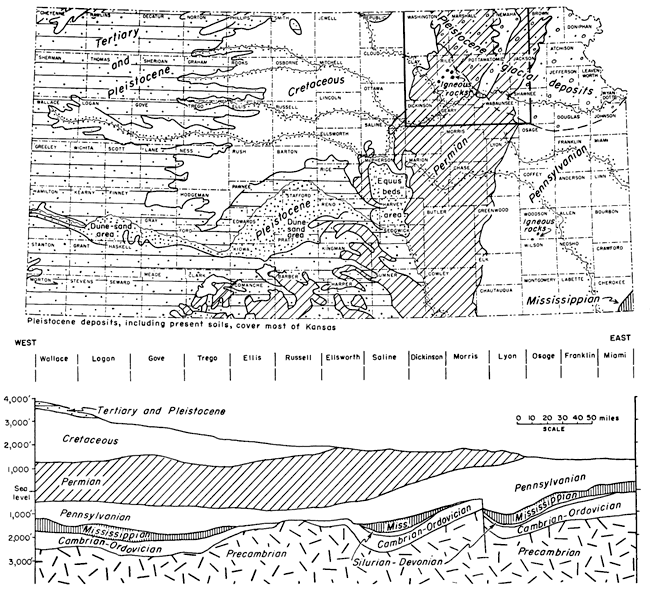
The subsurface structural geology of Kansas is in marked contrast to that of the surface. On the surface, sediments ranging in age from Mississippian in extreme southeastern Kansas through Permian in the Manhattan area form bands of outcrops radiating outward to the north and northeast from the Arbuckle mountains of Oklahoma. This fan-like array of outcrops (the Prairie Plains homocline) has a westward regional dip of about 14 feet per mile. West of Manhattan the Permian sediments are overlain successively and unconformably by Cretaceous, Tertiary, and Quaternary sediments. Thus, the surficial rocks are arranged as a series of younger plates stacked stair-step on top of each other from the Mississippian in the cast to the Quaternary in the west (Fig. 1).
Figure 1--Generalized geologic map of Kansas. Manhattan area shown in heavy outline. The gentle west-dipping structure revealed by the Pennsylvanian and Permian outcrops is the Prairie Plains homocline.
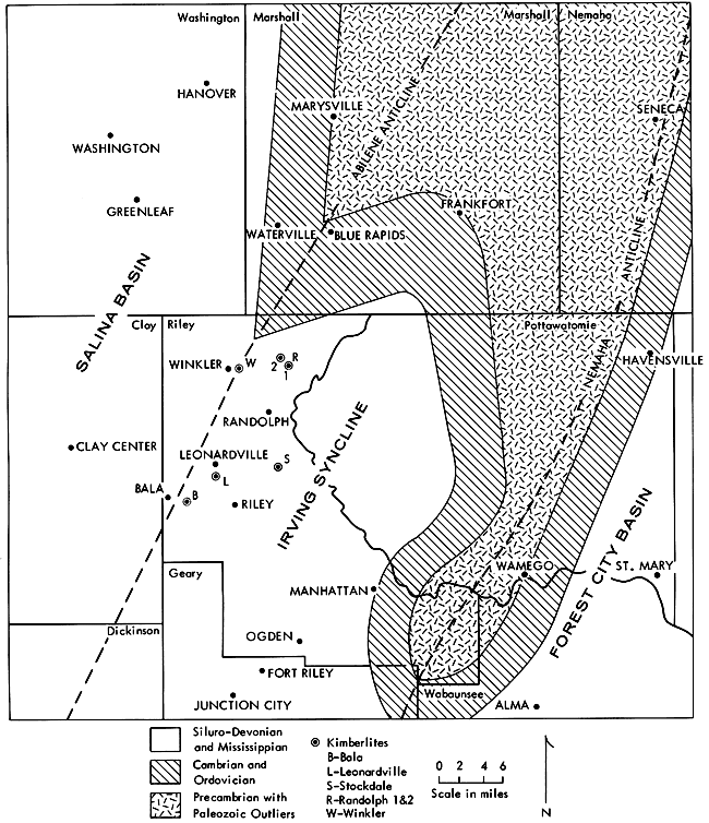
In sharp contrast to the relatively simple structure of surficial layers is the series of well-defined subsurface basins and anticlines lying below a major unconformity which developed in late Mississippian and early Pennsylvanian times. Listed in order from west to east across the Manhattan area, these structural features include the Salina basin, Abilene anticline, Irving syncline, Nemaha anticline, and Forest City basin. Manhattan lies in the area of the Irving syncline (Fig. 2).
Figure 2--Generalized subsurface structural geology of Manhattan, Kansas, area. Map shows location of kimberlite intrusives and the major structural elements underlying Pennsylvanian and Permian sediments.
Tectonically, the development of the surface and subsurface structures of the Manhattan area may be divided into three separate time periods: (1) pre-Mississippian, (2) late Mississippiaii and early Pennsylvanian, and (3) post-early Pennsylvanian. The post-early Pennsylvanian sediments generally mask the earlier formed structures except where the effects of differential compaction over buried topography and reactivated buried faults are translated to the surface. Some of the faults have been activated intermittently into recent times as is indicated by modern earthquakes along the east front of the Nemaha anticline.
Whereas the pre-Mississippian structural grain trends from northwest to southeast across the state (Ellis-Chautauqua arch segment of the Transcontinental arch), subsequent structures formed during the late Mississippian and early Pennsylvanian cut the older grain at right angles, and trend northeast-southwest. In fact, practically all of the major structures like the Abilene and Nemaha anticlines that postdate the early Mississippian are transverse to the more ancient structural grain. It is quite probable that all of these cross-cutting structures are related to reactivated buried faults along which both vertical and horizontal movements occurred. Such assumed movements combined with differential compaction would not only account for the trend of the Abilene and Nemaha anticlines but would also serve to explain ( 1) deflections in the regional joint pattern, (2) emplacement of kimberlite plugs and their relationship to certain minor folds and thrusts, and (3) the origin of high-angle faults.
This paper is based to a large degree upon structural geology research performed by graduate students under the writer's supervision. Graduate theses titles appear in the references.
The regional joint pattern in the Manhattan area (Fig. 3) consists principally of two major sets trending nearly at right angles to each other. The northerly trending set generally parallels the regional strike, the westerly trending set, the regional dip. At any given site other joints with different trends may occur, but such joints do not persist regionally. In some places the strike set butts against the dip set; however, in other locations the reverse is true. Thus, for the area as a whole, neither set dominates. Most of the joints dip vertically, but in thick shale sections some may be inclined. Except for master joints which cut across all of the layers in an outcrop, both the spacing and orientation of minor joints may vary from layer to layer.
Figure 3--Structural geology of Manhattan, Kansas, area (modified after Neff, 1949; Nelson, 1952). Map shows trend of regional joints. Note deflection in regional trend between north and south portions of map and local deflection over the Abilene anticline.
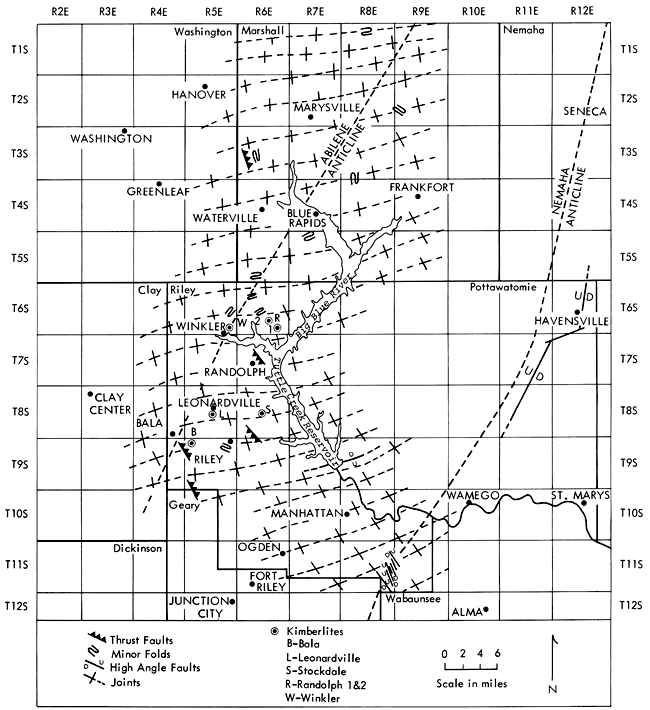
There are significant regional as well as more local deflections from straight-line trends. The northerly trending strike set of joints swing in a broad arc from a N 35° W direction in the south to a N 5° W direction in the north. The westerly trending dip set maintains a general 90-degree transverse relationship to the broad arc and changes in direction accordingly. However, in a zone extending from the town of Riley through the area of the kimberlite plugs and northward to Marysville there is a localized deflection of the westerly dip set that seems to be associated with the Abilene anticline. The strike of the joints ranges from N 75° E in the western part of the area to N 85° E over the mid-portion to N 55° E farther to the east (Fig. 3). On the basis of joint plane deflections, the Abilene anticlinal axis is probably located along a trend different from the conventional location shown in Figure 3. It would fit the joint pattern better if it were located 5 miles to the west of a line from Marysville to Riley. This line would connect points along the east-west set of joints where the maximum amount of deflection occurs. It is possible that the deflection is somehow related tectonically to the kimberlite plugs which occur in this general area. Speculation regarding the genetic relationship will be explored later.
The relationship between drainage and the regional joint system is revealed by the rather pronounced angular pattern of upland drainage, particularly where joint development is good; and also by the sine-shaped curve of Tuttle Creek Reservoir (Big Blue Valley). The northeast-trending portion of the curve approximately parallels the regional dip set of joints. The northwest-trending portions of the curve parallel the regional strike set of joints (Fig. 3).
Another peculiarity in local drainage as noted from a study of topographic maps is the asymmetrical shape of watersheds of some upland streams. The asymmetry is probably a reflection of the westerly regional dip of the rock layers. West-flowing tributaries in such watersheds are longer than their east-flowing counterparts.
Near Randolph (Fig. 3) the bedrock width of Tuttle Creek Reservoir at lake level is narrower than either the upstream or downstream portions of the valley. Speculation regarding the reason for this anomaly should consider the possibility of stream flow reversal by glacial ice of that portion of the Big Blue River valley north of Randolph. Evidence supporting such a possibility is the fact that the Black Vermillion River (cove near Frankfort, Fig. 3) appears very much "choked" with glacio-fluvial deposits (Walters, 1954) and is undoubtedly a misfit stream. It appears to occupy an earlier buried Pleistocene valley investigated by Frye and Walters in 1950. Borehole data on the elevation of the bedrock floor along the axis of the buried valley as well as along the axis of the Big Blue River valley to Randolph are needed to determine whether a north and easterly flowing drainage system existed prior to glaciation. It does not appear that there is any structural control other than joints and the possible reversal of drainage in the upper Big Blue River valley to account for the sine-shaped curve of the reservoir valley.
Six kimberlite plugs, Bala, Leonardville, Stockdale, Winkler, Randolph No. 1, and Randolph No. 2 (Fig. 3), are associated with that segment of the Abilene anticline where the regional joint pattern shows a marked deflection in trend, as previously described. The plugs, where exposed, are brecciated masses filled with fragments of country rock and appear as small elliptical outcrops averaging around 100 by 50 feet (Fig. 4). They appear to be elongate transverse to the trend of the Abilene anticline. The kimberlite composition implies an upper-mantle source for the magma. Fractures transverse to the anticline appear to have controlled the emplacement.
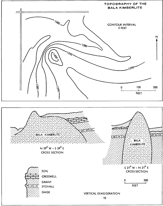
Figure 4--Topography of the Bala kimberlite (modified after Dryer, 1947). The elliptical outcrop shape of the Bala plug is probably typical of all kimberlites in the region. Note that elongation is parallel to the northwest set of joints.
Categorically, fractures are restricted to only two types, tension or shear. If shears are assumed to be the guiding influence, the shape of the intrusive bodies would be either (1) dike-like, if simple open shears cutting across the sialic crust were developed, or (2) curved arc-like bodies with crosswise flow structures, if closed compressional shears were developed along curved major shears as shown in Figure 5, Mammoth Embayment, California. In this case, however, it is very doubtful that kimberlites could be emplaced. Tight compression would preclude passageways through the sialic crust for the emplacement. The magma generated would be sialic in composition, and would be spontaneously emplaced along the same fracture along which it was generated, presumably through frictional heat.
Figure 5--Contrast in modes of magmatic emplacement into fractures under various tectonic conditions (Chelikowsky, 1940; 1951).
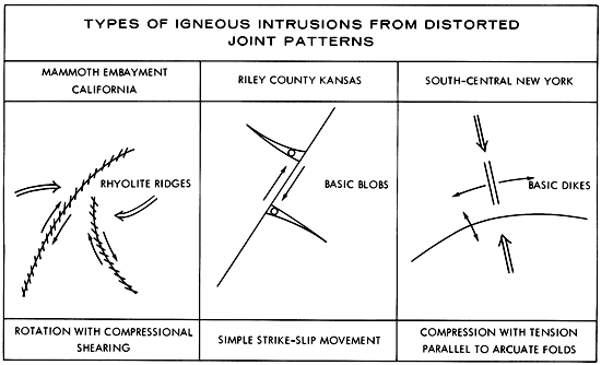
It would appear that neither of the above situations involving emplacement along shears is applicable to the origin of the plugs because they do not satisfactorily explain the shape of the bodies. Thus the remaining alternative, emplacement in open tension fractures, must afford the correct clue. In New York State (Parker, 1942), tension cracks opened up and remained open as illustrated in Figure 5, South Central New York, to produce long straight-walled dikes of kimberlite. Some have been traced along their outcrops for more than half a mile. Their width at depth as well as on the surface appears to remain remarkably uniform based upon observations of vertical exposures and the subsurface examination of one of the dikes in a salt mine. This straight-wall type of intrusion does not conform to the situation in Riley County. A more plausible explanation postulates emplacement in gash-type tension fractures as shown in Figure 5, Riley County. Such tension cracks develop transverse to strike-slip faults. Evidence for strike-slip movement is apparently revealed by the joint pattern deflections over the Abilene anticline. If a buried shear zone of strike-slip faults parallel to the Abilene axis were reactivated, the southward movement of easterly blocks would differentially drag the joint pattern of the overlying sediments to produce the observed deflections. The increase in the amount of deflection from Marshall County southward into Riley County, where the maximum is reached in the area of the kimberlites, would seem to indicate that the amount of strike slippage increases southward toward the deepest portion of the Irving syncline. At the time of faulting, gash fractures or pre-existing joints transverse to the fault would be opened suddenly because of frictional drag to permit an explosive injection of kimberlite capable of considerable shattering of country rock. This would produce a brecciated mass of rock fragments and magma. The "slamming shut" of fractures or gashes upon release of frictional drag along the fault would further impel the magma upward to form blob-like masses, greatly expanded in plastic formations and pinched off as thin threads in the stronger, more brittle formations. Fluttering action of the walls of the fractures due to minor frictional "hang-ups" along the fault would cause a pumping action that would serve to churn the magma before its final "slammed-shut" emplacement. In many respects the attendant features of the plugs have all the earmarks of typical cryptovolcanic structures. This is especially true of the Winkler plug. Here the kimberlite does not crop out, but its presence was verified by a 100-foot bore hole (Brookins, 1970a).
Thrust faults and minor folds appear in the same general Abilene anticlinal area (Fig. 3) as the kimberlite plugs. Both the faults and the folds are of relatively small magnitude. The thrusts are low-angle displacements, usually less than 5 feet, in which the heave may be double the amount of throw. The folds are generally small plunging structures comparable in magnitude to the thrusts. Those located just west of the town of Riley in the area of the municipal sanitary landfill on U.S. Highway 77 are a good example. They cover an area of a few thousand square feet, with some dips as high as 10 degrees. Sharply plunging folds and thrusts can be produced experimentally in overlying layers by strike-slip movement of a buried fault. The analogy is applicable to the Abilene anticline area and may be the explanation for the presence of these structures.
Some of the folds and thrusts in proximity to the kimberlite plugs may have been formed by the release of energy stored in the country rock when the intrusives were emplaced. The faulting and folding exposed in the Rock Island railroad cut southwest of the Bala plug may be an example of this type of deformation. The large horizontal girth of the Bala plug (Fig. 4) is seemingly the result of emplacement in the relatively plastic Gage and Grant shales which total more than 40 feet in thickness. Only the Stovall, a cherty limestone 1 foot thick at the base of the 10-foot Grant shale, could have offered non-plastic resistance to emplacement. Such resistance would be ineffectual because of the thinness of the unit. Flowage of the plastic shale toward the direction of erosional relief probably produced the deformation. The thin, brittle Stovall limestone was flexed and faulted by the drag effect of the plastic flow. Many of the thrusts and small folds throughout the Abilene anticline area may be an expression of erosional relief regardless of the cause of compression--strike-slip movement of a buried fault or magmatic emplacement.
Three high-angle fault areas appear to be associated with the Nemaha anticline: (1) eastern Pottawatomie County, (2) southeastern Riley County, and (3) the spillway outlet area of Tuttle Creek Reservoir. The fault involving the greatest amount of displacement occurs along the south-flowing Vermillion River (Fig. 3) in eastern Pottawatomie County. It can be traced for more than 12 miles south of Havensville, in northeastern Pottawatomie County, principally by outcroppings of zones of silicification in the Vermillion River valley. The west side has been displaced upward relative to the east side. At a location 1 mile north of Havensville, the older Brownville limestone occurs in juxtaposition with the Long Creek limestone, representing a stratigraphic throw of 170 feet (Fig. 6). Two miles south of Havensville, the older Tarkio limestone occurs at the level of the Brownville limestone, a stratigraphic throw of 150 feet. The fault is on the east flank of the Nemaha anticline and is parallel to its axis. The Vermillion River valley appears to be entrenched in the fault zone.
Figure 6--High-angle faults of southeastern Riley and eastern Pottawatomie counties. A, Cross section extends from the center of the eastern half of the NW sec. 32, T. 6 S., R. 12 E., to the center of the southern boundary of the SE of the section (modified after Ratcliff, 1957). B, Cross section extends from the SW corner sec. 25, T. 11 S., R. 8 E., to the NE corner of sec. 7, T. 11 S., R. 9 E. (modified after Bruton, 1957). A larger version of this figure is available.
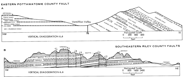
In southeastern Riley County a parallel series of seven northwest-trending faults occurs in an area no greater than 1.5 square miles (Figs. 3 and 6). Some of the faults are spaced less than a thousand feet apart. All are doubly hinged, and are generally less than 2 miles in length. The displacements vary from 0 at each end to as much as 30 feet in the central section. The four faults in the eastern area of the zone show a relative upward displacement of east walls. Two of the three to the west show upward displacements of west walls.
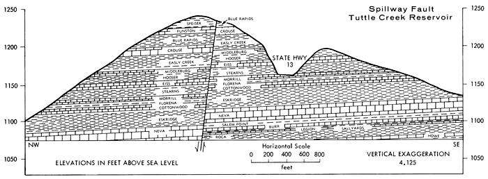
The fault at the spillway outlet of Tuttle Creek Reservoir may be traced eastward from the spillway in a N 80° E direction for about 1.8 miles to a tributary of Cedar Creek. Westward from the spillway the fault pursues a more nearly east-west trend across the reservoir into the first cove 1 mile north of the dam on the west side of the reservoir. It continues westward from the cove across the west shore drive for possibly another mile. The fault may be seen in the rock cut east of the observation point at the west end of the spillway flood gates (Fig. 7). The maximum displacement appears to be nearly 25 feet, with the south wall moved up relative to the north wall.
Figure 7--Fault exposed in the rock-cut wall of the east side of the spillway, Tuttle Creek Reservoir. A larger version of this figure is available.
In all three of the high-angle fault areas, faulting appears not to have produced new fractures but rather to have taken advantage of fractures already in existence, namely joints. This is particularly apparent in southeastern Riley County where the joints are quite conspicuous, as are the fault displacements. These faults generally parallel the northerly strike set of joints, although they may jog locally parallel to the dip set before again resuming their normal trend. The faults may branch around a joint block to produce a local horst or graben. This situation also occurs along the spillway fault in an outcrop along the aforementioned tributary of Cedar Creek and on the bluffs to the south. Here a graben-like joint block is clearly exposed. The eastern Pottawatomie County fault cannot be traced as accurately as those in the other two areas because of the general glacial and fluvial cover in the Vermillion River valley. Although the fault as shown on the regional map (Fig. 3) appears to strike diagonally across the joint system, it actually zigzags locally to follow the joint pattern. A major offset paralleling the westerly set of joints occurs near Havensville.
If the joints in the surficial rocks of the Manhattan area were developed prior to faulting, then all of the high-angle faults of the area must be the result of the vertical reactivation of buried faults.
The surface structures of the Manhattan area seem to be a reflection of subsurface features translated to the surface by differential compaction or are features that resulted from the reactivation of buried faults. The Abilene anticline deflections in the regional joint pattern appear to be the result of right-lateral strike slippage with the greatest amount of movement down and into the deepest portion of the Irving syncline, the site of the kimberlite plugs. The implied genetic relationships of strike-slip movement to produce the intrusives seems reasonable, but the cause for the movement is a matter of speculation. That the high-angle faults in southeastern Riley County and eastern Pottawatomie County took advantage of an already existing fracture pattern (joints) is rather obvious. But, the relative difference in the time of strike-slip faulting and high-angle faulting is not known. However, numerous earthquake tremors in the area of the Nemaha anticline have been recorded in recent times, and the Nemaha area is the principal location of the high-angle faults.
Joint control of streams is quite apparent, and some of the upland streams seem to reflect regional dip as asymmetrical watersheds. The sine-shaped curve of Tuttle Creek Reservoir fits the regional joint pattern, and does not appear to be controlled by local flexures. Whether that part of Tuttle Creek Reservoir north of Randolph was part of a north-flowing preglacial drainage system remains to be proved.
Baehr, W. M., 1954, An investigation of the relationships between rock structure and drainage in the southern half of the Junction City, Kansas, Quadrangle: Unpub. M.S. thesis, Kansas State Univ., 68 p.
Brookins, D. G., 1970a, Kimberlite at Winkler Crater, Kansas: Geol. Soc. America Bull., v. 81, no. 2, p. 541-546.
Brookins, D. G., 1970b, The kimberlites of Riley County, Kansas: Kansas Geol. Survey, Bull. 200, 32 p. [available online]
Bruton, R. L., 1958, The geology of the fault area in southeast Riley County, Kansas: Unpub. M.S. thesis, Kansas State Univ., 44 p.
Byrne, F. E., Parish, K. L., and Crumpton, C. F., 1956, Igneous intrusions in Riley County, Kansas: Am. Assoc. Petroleum Geologists, Bull., v. 40, p. 377-387.
Chelikowsky, J. R., 1940, Tectonics of the rhyolite in the Mammoth Embayment of California: Jour. Geol., no. 4, p. 421-435.
Chelikowsky, J. R., 1951, Note on the evidence for strike slip faulting in the basement complex of the Abilene anticline of Riley County, Kansas: Abstract of paper presented at annual meeting, Am. Assoc. Petroleum Geologists, St. Louis, Apr. 23-26.
Chelikowsky, J. R., and Nelson, P. D., 1951, Preliminary note on evidence for strike slip faulting in the Abilene anticline area of Kansas: Paper read at 83rd Annual Meeting, Kansas Acad. Sci., Univ. Kansas, Lawrence, Kansas.
Cook, K. L., 1955, Magnetic surveys over serpentine masses, Riley County, Kansas: Mining Eng., v. 7, p. 481-488.
Dreyer, R. M., 1947, Magnetic survey of the Bala intrusive, Riley County, Kansas: Kansas Geol. Survey, Bull. 70, p. 21-28. [available online]
Frye, J. C., and Walters, K. L., 1950, Subsurface reconnaissance of glacial deposits in northeastern Kansas: Kansas Geol. Survey, Bull. 86, pt. 6, p. 143-158. [available online]
Jewett, J. M., 1941, The geology of Riley and Geary counties, Kansas: Kansas Geol. Survey, Bull. 39, 164 p. [available online]
Jewett, J. M., 1951, Geologic structures in Kansas: Kansas Geol. Survey, Bull. 90, pt. 6, p. 108-172. [available online]
König, Michael, 1971, A magnetic profile across the Nemaha anticline in Pottawatomie and western Jackson counties, Kansas: Unpub. M.S. thesis, Kansas State Univ.
Koons, D. L., 1956, Faulting as a possible origin for the formation of the Nemaha anticline: Unpub. M.S. thesis, Kansas State Univ., 33 p.
Lee, Wallace, 1943, The stratigraphy and structural development of the Forest City Basin in Kansas: Kansas Geol. Survey, Bull. 51, 142 p. [available online]
Lee, Wallace, 1956, Stratigraphy and structural development of the Salina Basin area: Kansas Geol. Survey, Bull. 121, 167 p. [available online]
Merriam, D. F., 1963, The geologic history of Kansas: Kansas Geol. Survey, Bull. 162, 317 p. [available online]
Mudge, M. R., and Barton, R. H., 1959, Geology of Wabaunsee County, Kansas: U.S. Geol. Survey, Bull. 1068, p. 1-210. [available online]
Mudge, M. R., Walters, C. P., and Skoog, R. E., 1959, Geology and material resources of Nemaha County, Kansas: U.S. Geol. Survey, Bull. 1060-D, p. 179-254. [available online]
Neff, A. W., 1949, A study of the fracture patterns of Riley County, Kansas: Unpub. M.S. thesis, Kansas State Univ., 47 p.
Nelson, P. D., 1952, The reflection of the basement complex in the surface structures of the Marshall-Riley County area of Kansas: Unpub. M.S. thesis, Kansas State Univ., 73 p.
Parker, J.M., III, 1942, Regional systematic jointing in slightly deformed sedimentary rocks: Geol. Soc. America, v. 53, p. 381-408.
Ratcliff, G. A., 1957, Surface structure on the east flank of the Nemaha anticline in northeast Pottawatomie County, Kansas: Unpub. M.S. thesis, Kansas State Univ., 33 p.
Rieb, S. L., 1954, Structural geology of the Nemaha Ridge in Kansas: Unpub. M.S. thesis, Kansas State Univ., 40 p.
Scott, G. R., Foster, F. W., and Crumpton, C. F., 1959, Geology and material resources of Pottawatomie County, Kansas: U.S. Geol. Survey, Bull. 1060-C, p. 97-178. [available online]
Shenkel, C. W., 1959, Geology of the Abilene anticline in Kansas: Guidebook Twenty-fourth Field Conf., Kansas Geol. Society, Oct. 1959, p. 114-128.
Taylor, W. K., 1950, Study of structural relationship of the Riley County, Kansas, intrusions to the Abilene anticline: Unpub. M.S. thesis, Kansas State Univ., 25 p.
Walters, K. L., 1954, Geology and ground-water resources of Marshall County, Kansas: Kansas Geol. Survey, Bull. 106, 116 p. [available online]
Walters, K. L., and Bayne, C. K., 1959, Geology and ground-water resources of Clay County, Kansas: Kansas Geol. Survey, Bull. 136, 106 p. [available online]
Kansas Geological Survey, Geology
Placed on web Oct. 31, 2008; originally published in Oct. 1972.
Comments to webadmin@kgs.ku.edu
The URL for this page is http://www.kgs.ku.edu/Publications/Bulletins/204_4/index.html